Harmonized World Soil Database v 1.2

This is the result of a collaboration between the FAO with IIASA, ISRIC-World Soil Information, Institute of Soil Science, Chinese Academy of Sciences (ISSCAS), and the Joint Research Centre of the European Commission (JRC)
The Harmonized World Soil Database is a 30 arc-second raster database with over 15 000 different soil mapping units that combines existing regional and national updates of soil information worldwide (SOTER, ESD, Soil Map of China, WISE) with the information contained within the 1:5 000 000 scale FAO-UNESCO Soil Map of the World (FAO, 1971-1981).
The resulting raster database consists of 21600 rows and 43200 columns, which are linked to harmonized soil property data. The use of a standardized structure allows for the linkage of the attribute data with the raster map to display or query the composition in terms of soil units and the characterization of selected soil parameters (organic Carbon, pH, water storage capacity, soil depth, cation exchange capacity of the soil and the clay fraction, total exchangeable nutrients, lime and gypsum contents, sodium exchange percentage, salinity, textural class and granulometry).
Download : Download viewer & data (only soil types) | Download database (.mdb) | HWSD Raster | Technical Report and Instructions
A selection of the data is downloadable and available here :
Global Terrain Slope and Aspect Data
The data include an elevation map describing median elevation in each grid cell, eight slope maps, and five aspect maps describing distributions (i.e. pixel counts) of the respective slope or aspect classes calculated for 3 arc-sec data and accumulated to 30 arc-sec and 5 min latitude/longitude grid cells respectively. A detailed description including technical details is provided in the documentation file.
The data is saved in RAR archives. More information about the RAR archive format, may be found elsewhere on the net.
Grid cell size: 5 minutes: | |
LAND MASK | |
Number of 3 arc second grid cells that belong to the land mask and fall into 5 minutes grid cells | |
ELEVATION |
|
Median elevation (meters) | |
SLOPES (view median slope) | Slope class |
0 % ≤ slope ≤ 0.5 % | |
0.5 % ≤ slope ≤ 2 % | |
2 % ≤ slope ≤ 5 % | |
5 % ≤ slope ≤ 10 % | |
10 % ≤ slope ≤ 15 % | |
15 % ≤ slope ≤ 30 % | |
30 % ≤ slope ≤ 45 % | |
Slope > 45 % | |
ASPECT (view dominant aspect) | Aspect class |
North: 0˚< aspect ≤45˚ or | |
East: 45˚ < aspect ≤ 135˚ | |
South: 135˚ < aspect ≤ 225˚ | |
West: 225˚ < aspect ≤ 315˚ | |
Undefined: Slope aspect undefined; this value is used for grids where slope gradient is undefined or slope gradient is less than 2%. | |
Grid cell size: 30 arc-seconds: | |
LAND MASK | |
Number of 3 arc second grid cells that belong to the land mask and fall into 30 arcsecond grid cells | |
ELEVATION |
|
Median elevation (meters) | |
SLOPES | Slope class |
0 % ≤ slope ≤ 0.5 % | |
0.5 % ≤ slope ≤ 2 % | |
2 % ≤ slope ≤ 5 % | |
% ≤ slope ≤ 10 % | |
10 % ≤ slope ≤ 15 % | |
15 % ≤ slope ≤ 30 % | |
30 % ≤ slope ≤ 45 % | |
Slope > 45 % | |
ASPECT | Aspect class |
North: 0˚< aspect ≤45˚ or 315˚< aspect ≤360˚ | |
East: 45˚ < aspect ≤ 135˚ | |
South: 135˚ < aspect ≤ 225˚ | |
West: 225˚ < aspect ≤ 315˚ | |
Undefined: Slope aspect undefined; this value is used for grids where slope gradient is undefined or slope gradient is less than 2%. | |
Data Citation:
Fischer, G., F. Nachtergaele, S. Prieler, H.T. van Velthuizen, L. Verelst, D. Wiberg, 2008. Global Agro-ecological Zones Assessment for Agriculture (GAEZ 2008). IIASA, Laxenburg, Austria and FAO, Rome, Italy.
Global Terrain Slope and Aspect Data
Data source
The NASA Shuttle Radar Topographic Mission (SRTM) has provided digital elevation data (DEMs) for over 80% of the globe. The SRTM data is publicly available as 3 arc second (approximately 90 meters resolution at the equator) DEMs (CGIAR-CSI, 2006).
For latitudes over 60 degrees north elevation data from GTOPO30 (USGS, 2002) with a resolution of 30 arc-seconds (depending on latitude this is approximately a 1 by 1 km cell size) were used.
References
CGIAR-CSI (2006): NASA Shuttle Radar Topographic Mission (SRTM). The SRTM data is available as 3 arc second (approx. 90m resolution) DEMs. The dataset is available for download at: http://srtm.csi.cgiar.org/
USGS (2002): GTOPO30 – Global 30 arc second elevation data. U.S. Geological Survey, National Mapping Division, EROS Data Center; for download available at: https://lta.cr.usgs.gov/GTOPO30
Processing Steps
Under an agreement with the National Aeronautics and Space Administration (NASA) and the Department of Defense's National Geospatial Intelligence Agency (NGA), the U.S. Geological Survey (USGS) is now distributing elevation data from the Shuttle Radar Topography Mission (SRTM). The SRTM is a joint project between NASA and NGA to map the Earth’s land surface in three dimensions at a level of detail unprecedented for such a large area. Flown aboard the NASA Space Shuttle Endeavour February 11-22, 2000, the SRTM successfully collected data from over 80 percent of the Earth’s land surface, for most of the area between 60º N. and 56º S. latitude.
The data currently being distributed by NASA/USGS (finished product) contains “no-data” holes where water or heavy shadow prevented the quantification of elevation. These are generally small holes, which nevertheless render the data less useful, especially in fields of hydrological modelling. Dr. Andrew Jarvis of the CIAT Land Use project, in collaboration with Dr. Robert Hijmans and Dr. Andy Nelson, have further processed the original DEMs to fill in these no-data voids. This involved the production of vector contours, and the re-interpolation of these derived contours back into a raster DEM. These interpolated DEM values were then used to fill in the original no-data holes within the SRTM data.
The DEM files have been mosaiced into a seamless global coverage, and are available for download as 5˚ x 5˚ tiles, in geographic coordinate system - WGS84 datum. The available data cover a raster of 24 rows by 72 columns of 5˚ x 5˚ latitude/longitude tiles, from north 60 degree latitude to 56 degree south.
These processed SRTM data, with a resolution of 3 arc second (approximately 90m at the equator), i.e. 6000 rows by 6000 columns for each 5˚ x 5˚ tile, have been used for calculating: (i) terrain slope gradients for each 3 arc-sec grid cell; (ii) aspect of terrain slopes for each 3 arc-sec grid cell; (iii) terrain slope class by 3 arc-sec grid cell; and (iv) aspect class of terrain slope by 3 arc-sec grid cell. Products (iii) and (iv) were then aggregated to provide distributions of slope gradient and slope aspect classes by 30 arc-sec grid cell and for a 5’x5’ latitude/longitude grid used in global AEZ.
The computer algorithm used to calculate slope gradient and slope aspect operates on sub-grids of 3 by 3 grid cells, say grid cells A to I:
A B C
D E F
G H I
SRTM data are stored in 5˚x5˚ tiles*. When E falls on a border row or column (i.e., rows or columns 1 or 6000 of a tile) the required values falling outside the current tile are filled in from the neighboring tiles.
To calculate terrain slope for grid cell E, the algorithm proceeds as follows:
1.) If the altitude value at E is ‘no data’ then both slope gradient and slope aspect are set to ‘no data’.
2.) Replace any ‘no data’ values in A to D and F to I by the altitude value at E.
Let Px, Py and Pz denote respectively coordinates of grid point P in x direction (i.e. longitude in our case), y direction (i.e. latitude in our application), and z in vertical direction (i.e., altitude), then calculate partial derivatives (dz/dx) and (dz/dy) from:
(dz/dx) = - ((Az-Cz) + 2∙ (Dz-Fz) + (Gz-Iz)) / (8∙size_x)
(dz/dy) = ((Az-Gz) + 2∙ (Bz-Hz) + (Cz-Iz)) / (8∙size_y)
When working with a grid in latitude and longitude, then size_y is constant for all grid cells. However, size_x depends on latitude and is calculated separately for each row of a tile.
The slope gradient (in degrees) at E is
slgE = arctan![]()
and in percent is given by
slpE = 100 ![]()
The slope aspect, i.e. the orientation of the slope gradient, starting from north (0 degrees) and going clock-wise, is calculated using the variables from above, as follows:
aspE = arctan ![]()
The above expression can be evaluated for (dz/dy) ≠ 0. Otherwise aspE = 45˚ (for (dz/dx) < 0) or aspE = 270˚ (for (dz/dx) > 0)
3.) To produce distributions of slope gradients and aspects for grids at 30 arc-sec or 5 min latitude/longitude, slope gradients are groups into 9 classes:
C1: 0 % ≤ slope ≤ 0.5 %
C2: 0.5 % ≤ slope ≤ 2 %
C3: 2 % ≤ slope ≤ 5 %
C4: 5 % ≤ slope ≤ 10 %
C5: 10 % ≤ slope ≤ 15 %
C6: 15 % ≤ slope ≤ 30 %
C7: 30 % ≤ slope ≤ 45 %
C8: Slope > 45 %
C9: Slope gradient undefined (i.e., outside land mask)
Slope aspects are classified in 5 classes:
N: 0˚ < aspect ≤ 45˚ or 315˚ < aspect ≤ 360˚
E: 45˚ < aspect ≤ 135˚
S: 135˚ < aspect ≤ 225˚
W: 225˚ < aspect ≤ 315˚
U: Slope aspect undefined; this value is used for grids where slope gradient is undefined or slope gradient is less than 2 %.
Detailed data description
Data Format:
The data are provided as ASCII files in a grid format. They consist of header information containing a set of keywords, followed by cell values in row-major order. The file format is
NCOLS xxx
NROWS xxx
XLLCENTER xxx | xllcorner xxx>
YLLCENTER xxx | yllcorner xxx>
CELLSIZE xxx
NODATA_VALUE xxx
row 1
row 2
.
row n
where xxx is a number. Row 1 of the data is at the top of the grid, row 2 is just under row 1 and so on. The end of each row of data from the grid is terminated with a carriage return in the file. The grid is defined in the header information with the following keywords:
NCOLS: number of columns
NROWS: number of rows
XLLCENTER: x-coordinate of lower left centre
YLLCENTER: y-coordinate of lower left centre
CELLSIZE: grid cell size
NODATA_VALUE: The value assigned to nodata information
Geographical details
Spatial coverage: Global
Grid cell size: 5 minutes and 30 arc seconds
Projection:
Geographic coordinate system (Longitude, latitude)
Units: Decimal degrees
Datum: WGS84
Data content
The data comprise one elevation map describing median elevation in each grid cell, eight slope and four aspect maps describing percentage distributions of the respective slope or aspect classes. The sum of all classes for slopes and aspects respectively is 100 percentages.
Units:
Elevation data: | meters |
Slope and aspect classes: | percentage * 1000 |
Land mask:
In addition a land mask has been provided. The land mask shows the number of 3 arc second grid cells in the SRTM data that fall into a 5 minutes or 30 arc second grid cell. Along coastlines 5 minutes or 30 arcsecond grid cells usually only contain a fraction of the higher resolution 3 arc second grid cells, which were used for the slope and aspect calculations. In the 5 minutes and 30 arc second grids the slopes and aspect distributions always sum up to 100 percent. Thus if the real percentage distribution of a particular 5 minutes or 30 arc second is required it can be calculated using the land mask.
Table 1. Description of file names of the IIASA-LUC Global Terrain Slopes and Aspect Database.
FILE NAMES |
| Description |
grid cell size: | grid cell size: |
|
LAND MASK |
|
|
GloLand_5min | GloLand_30as | Number of 3 arc second grid cells that belong to the land mask and fall into respective 5 minutes or 30 arc second grid cells |
ELEVATION |
|
|
GloElev_5min | GloElev_30as | Median elevation (meters) |
SLOPES |
| Slope class |
GloSlopesCl1_5min | GloSlopesCl1_30as | 0 % ≤ slope ≤ 0.5 % |
GloSlopesCl2_5min | GloSlopesCl2_30as | 0.5 % ≤ slope ≤ 2 % |
GloSlopesCl3_5min | GloSlopesCl3_30as | 2 % ≤ slope ≤ 5 % |
GloSlopesCl4_5min | GloSlopesCl4_30as | 5 % ≤ slope ≤ 10 % |
GloSlopesCl5_5min | GloSlopesCl5_30as | 10 % ≤ slope ≤ 15 % |
GloSlopesCl6_5min | GloSlopesCl6_30as | 15 % ≤ slope ≤ 30 % |
GloSlopesCl7_5min | GloSlopesCl7_30as | 30 % ≤ slope ≤ 45 % |
GloSlopesCl8_5min | GloSlopesCl8_30as | Slope > 45 % |
ASPECT |
| Aspect class |
GloAspectClN_5min | GloAspectClN_30as | North: 0˚< aspect ≤45˚ or 315˚< aspect ≤360˚ |
GloAspectClE_5min | GloAspectClE_30as | East: 45˚ < aspect ≤ 135˚ |
GloAspectClS_5min | GloAspectClS_30as | South: 135˚ < aspect ≤ 225˚ |
GloAspectClW_5min | GloAspectClW_30as | West: 225˚ < aspect ≤ 315˚ |
GloAspectClU_5min | GloAspectClU_30as | Undefined: Slope aspect undefined; this value is used for grids where slope gradient is undefined or slope gradient is less than 2%. |
*For the globe the computer program processes 36 million sub-grids, in total 32.4 billion sub-grids are considered.
Data Citation
IIASA/FAO, 2010. Global Agro-ecological Zones (GAEZ v3.0). IIASA, Laxenburg, Austria and FAO, Rome, Italy.
Land Use and Land Cover
The data is presented as a percentage share of the total grid-cell extent for a 5' latitude by 5' longitude grid-cell.
Note that the data files are in ascii format. The best way to save them to your computer is to click on the link with the right mouse button and select "Save Link As..." or "Save Target As...". More information on the data format is on the data format page.
DATA FILES | MAP | |
rain-fed cultivated land | ||
irrigated cultivated land, according to GMIA 4.0 | ||
total cultivated land | ||
forest land, calibrated to FRA2000 land statistics | ||
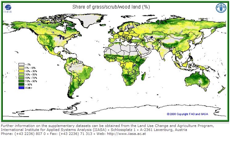
grass/scrub/woodland | ||
built-up land (residential and infrastructure) | ||
barren/very sparsely vegetated land | ||
mapped water bodies |
|
Data Citation:
Fischer, G., F. Nachtergaele, S. Prieler, H.T. van Velthuizen, L. Verelst, D. Wiberg, 2008. Global Agro-ecological Zones Assessment for Agriculture (GAEZ 2008). IIASA, Laxenburg, Austria and FAO, Rome, Italy.
Land Use and Land Cover
View map of dominant land cover pattern
Six geographic datasets were used for the compilation of an inventory of seven major land cover/land use categories at 5’ resolution. The datasets used are:
- GLC2000 land cover database at 30 arc-sec (https://ec.europa.eu/jrc/en/scientific-tool/global-land-cover), using regional and global legends;
- an IFPRI global land cover categorization providing 17 land cover classes at 30 arc-sec. (IFPRI, 2002), based on a reinterpretation of the Global Land Cover Characteristics Database (GLCC ver. 2.0), EROS Data Centre (EDC, 2000);
- FAO’s Global Forest Resources Assessment 2000 (FAO, 2001) at 30 arc-sec. resolution;
- digital Global Map of Irrigated Areas (GMIA) version 4.0 of (FAO/University of Frankfurt) at 5’ by 5’ latitude/longitude resolution, providing by grid-cell the percentage land area equipped with irrigation infrastructure;
- IUCN-WCMC protected areas inventory at 30-arc-seconds (http://www.unep-wcmc.org/wdpa/index.htm), and
- a spatial population density inventory (30-arc seconds) for year 2000 developed by FAO-SDRN, based on spatial data of LANDSCAN 2003, with calibration to UN 2000 population figures.
An iterative calculation procedure has been implemented to estimate land cover class weights, consistent with aggregate FAO land statistics and spatial land cover patterns obtained from (the above mentioned) remotely sensed data, allowing the quantification of major land use/land cover shares in individual 5’ by 5’ latitude/longitude grid cells. The estimated class weights define for each land cover class the presence of respectively cultivated land and forest. Starting values of class weights used in the iterative procedure were obtained by cross-country regression of statistical data of cultivated and forest land against land cover class distributions obtained from GIS, aggregated to national level. The percentage of urban/built-up land in a grid-cell was estimated based on presence of respective land cover classes as well as regression equations relating built-up land with number of people and population density. Remaining areas were allocated to:
- grassland and other vegetated areas (excluding cultivated land and forest);
- barren or very sparsely vegetated areas, and
- water bodies
according to indicated land cover classes. Barren or very sparsely vegetated areas (class (ii) above) were delineated from (i) using the respective land cover information in GLC 2000 and a minimum bio-productivity threshold.
The resulting seven land use land cover categories shares are:
- Rain-fed cultivated land;
- Irrigated cultivated land;
- Forest;
- Pastures and other vegetated land;
- Barren and very sparsely vegetated land;
- Water; and
- Urban land and land required for housing and infrastructure.
Data Citation:
Fischer, G., F. Nachtergaele, S. Prieler, H.T. van Velthuizen, L. Verelst, D. Wiberg, 2008. Global Agro-ecological Zones Assessment for Agriculture (GAEZ 2008). IIASA, Laxenburg, Austria and FAO, Rome, Italy.
Soil Qualities for Crop Production
Note that the data files are in ascii format. The best way to save them to your computer is to click on the link with the right mouse button and select "Save Link As..." or "Save Target As...". More information on the data format is on the data format page.
DATA FILES | MAPS | |
Nutrient availability | ||
Nutrient retention capacity | ||
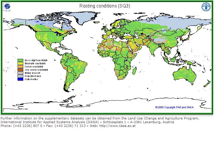
Rooting conditions | ||
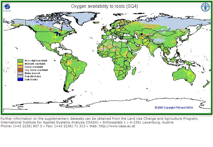
Oxygen availability to roots | ||
Excess salts. | ||
Toxicity | ||
Workability (constraining field management) |
Note that the classes used in the Soil Quality evaluation are:
1: No or slight limitations
2: Moderate limitations
3: Sever limitations
4: Very severe limitations
5: Mainly non-soil
6: Permafrost area
7: Water bodies
Remember that classes are qualitative not quantitative. Only classes 1 to 4 are corresponding to an assessment of soil limitations for plant growth. Class 1 is generally rated between 80 and 100% of the growth potential, class 2 between 60 and 80%, class 3 between 40 and 60%, and class 4 less than 40%.
For further information please consult the following link
Data Citation:
Fischer, G., F. Nachtergaele, S. Prieler, H.T. van Velthuizen, L. Verelst, D. Wiberg, 2008. Global Agro-ecological Zones Assessment for Agriculture (GAEZ 2008). IIASA, Laxenburg, Austria and FAO, Rome, Italy.
Soil Qualities for Crop Production
On the basis of soil parameters provided by HWSD seven key soil qualities important for crop production have been derived, namely: nutrient availability, nutrient retention capacity, rooting conditions, oxygen availability to roots, excess salts, toxicities, and workability. Soil qualities are related to the agricultural use of the soil and more specifically to specific crop requirements and tolerances. For the illustration of soil qualities, maize was selected as reference crop because of its global importance and wide geographical distribution.
Soil qualities and related soil characteristics
Soil Qualities | Soil Characteristics | |
SQ1 | Nutrient availability | Soil texture, soil organic carbon, soil pH, total exchangeable bases |
SQ2 | Nutrient retention capacity | Soil Organic carbon, Soil texture, base saturation, cation exchange capacity of soil and of clay fraction |
SQ3 | Rooting conditions | Soil textures, bulk density, coarse fragments, vertic soil properties and soil phases affecting root penetration and soil depth and soil volume |
SQ4 | Oxygen availability to roots | Soil drainage and soil phases affecting soil drainage |
SQ5 | Excess salts. | Soil salinity, soil sodicity and soil phases influencing salt conditions |
SQ6 | Toxicity | Calcium carbonate and gypsum |
SQ7 | Workability (constraining field management) | Soil texture, effective soil depth/volume, and soil phases constraining soil management (soil depth, rock outcrop, stoniness, gravel/concretions and hardpans) |
Soil qualities have been estimated for the sequence 1 soils in each grid cell with as reference crop maize. The derived maps for the individual soil qualities represent therefore the qualities of ‘main soils’ only.
Details of estimation procedures for the individual soil qualities from soil characteristics in HWSD are:
Nutrient availability (SQ1)
This soil quality is decisive for successful low level input farming and to some extent also for intermediate input levels. Diagnostics related to nutrient availability are manifold. Important soil characteristics of the topsoil (0-30 cm) are: Texture/Structure, Organic Carbon (OC), pH and Total Exchangeable Bases (TEB). For the subsoil (30-100 cm), the most important characteristics considered are: Texture/Structure, pH and TEB.
The soil characteristics relevant to soil nutrient availability are to some extent correlated. For this reason, the most limiting soil characteristic is combined in the evaluation with the average of the remaining less limiting soil characteristics to represent soil quality SQ1.
Nutrient retention capacity (SQ2)
Nutrient retention capacity is of particular importance for the effectiveness of fertilizer applications and is therefore of special relevance for intermediate and high input level cropping conditions.
Nutrient retention capacity refers to the capacity of the soil to retain added nutrients against losses caused by leaching. Plant nutrients are held in the soil on the exchange sites provided by the clay fraction, organic matter and the clay-humus complex. Losses vary with the intensity of leaching which is determined by the rate of drainage of soil moisture through the soil profile. Soil texture affects nutrient retention capacity in two ways, through its effects on available exchange sites on the clay minerals and by soil permeability.
The soil characteristics used for topsoil are respectively: Organic Carbon (OC), Soil Texture (Text), Base Saturation (BS), Cation Exchange Capacity of soil (CECsoil), pH, and Cation Exchange Capacity of clay fraction (CECclay). Soil pH serves as indicator for aluminum toxicity and for micro-nutrient deficiencies.
The most limitingof these soil characteristic is combined with the average of the remaining less limiting soil characteristics to estimate nutrient retention capacity SQ2.
Rooting conditions (SQ3)
Rooting conditions include effective soil depth (cm) and effective soil volume (vol. %) related to presence of gravel and stoniness. Rooting conditions may be affected by the presence of a soil phase either limiting the effective rooting depth or decreasing the effective volume accessible for root penetration. Rooting conditions address various relations between soil conditions of the rooting zone and crop growth. The following factors are considered in the evaluation:
- Adequacy of foothold, i.e., sufficient soil depth for the crop for anchoring;
- available soil volume and penetrability of the soil for roots to extract nutrients;
- space for root and tuber crops for expansion and economic yield in the soil; and
- absence of shrinking and swelling properties (vertic) affecting root and tuber crops.
Soil depth/volume limitations affect root penetration and may constrain yield formation (roots and tubers). Relevant soil properties considered are: soil depth, soil texture/structure, vertic properties, gelic properties, petric properties and presence of coarse fragments. This soil quality is estimated by multiplying of the soil depth limitation with the most limiting soil or soil phase property
Soil phases that relevant for rooting conditions vary somewhat with source of soil map and soil classification used. In the HWSD these are:
- FAO 74 soil phases: stony, lithic, petric, petrocalcic, petrogypsic, petroferric, fragipan and duripan.
- FAO 90 soil phases: rudic, lithic, pertroferric, placic, skeletic, fragipan and duripan.
- ESB soil phases and other soil depth/volume related characteristics: stony, lithic, petrocalcic, petroferric, fragipan and duripan, and presence of gravel or concretions, obstacles to roots (6 classes), and impermeable layers (4 classes).
Oxygen availability (SQ4)
Oxygen availability in soils is largely defined by drainage characteristics of soils. The determination of soil drainage classes is based on procedures developed at FAO (FAO 1995). These procedures take into account soil type, soil texture, soil phases and terrain slope.
Apart from drainage characteristics, the soil quality of oxygen availability may be influenced by soil and terrain characteristics that are defined through the occurrence of specific soil phases. These include for the FAO ‘74 classification soil phases indicating phreatic conditions, and for the FAO ’90 classification soil phases indicating respectively phreatic, anthraquic, inundic, or placic conditions.
Excess salts (SQ5)
Accumulation of salts may cause salinity. Excess of free salts referred to as soil salinity is measured as Electric Conductivity (EC in dS/m) or as saturation of the exchange complex with sodium ions, which is referred to as sodicity or sodium alkalinity and is measured as Exchangeable Sodium Percentage (ESP).
Salinity affects crops through inhibiting the uptake of water. Moderate salinity affects growth and reduces yields; high salinity levels may kill the crop. Sodicity causes sodium toxicity and affects soil structure leading to massive or coarse columnar structure with low permeability. Apart from soil salinity and sodicity, conditions indicated by saline (salic) and sodic soil phases may affect crop growth and yields.
In case of simultaneous occurrence of saline (salic) and sodic soils the limitations are combined. The most limiting of the combined soil salinity and/or sodicity conditions and occurrence of saline (salic) and/or sodic soil phase is selected.
3.2.6 Toxicities (SQ.6)
Low pH leads to acidity related toxicities, e.g., aluminum, iron, manganese toxicities, and to various deficiencies, e.g., of phosphorus and molybdenum. Calcareous soils exhibit generally micronutrient deficiencies, for instance of iron, manganese, and zinc and in some cases toxicity of molybdenum. Gypsum strongly limits available soil moisture. Tolerance of crops to calcium carbonate and gypsum varies widely (FAO, 1990; Sys, 1993).
Low pH and high calcium carbonate and gypsum are mutually exclusive. Acidity related toxicities such as aluminum toxicities and micro-nutrient deficiencies are accounted for respectively in SQ1, nutrient availability, and in SQ2, nutrient retention capacity. This soil quality SQ6 is therefore only including calcium carbonate and gypsum related toxicities. The most limiting of the combination of excess calcium carbonate and gypsum in the soil, and occurrence of petrocalcic and petrogypsic soil phases is selected for the quantification of SQ6.
Workability (SQ7)
Diagnostic characteristics to indicate soil workability vary by type of management applied. Workability or ease of tillage depends on interrelated soil characteristics such as texture, structure, organic matter content, soil consistence/bulk density, the occurrence of gravel or stones in the profile or at the soil surface, and the presence of continuous hard rock at shallow depth as well as rock outcrops. Some soils are easy to work independent of moisture conditions, other soils are only manageable at an adequate moisture status, in particular for manual cultivation or light machinery. Irregular soil depth, gravel and stones in the profile and rock outcrops, might prevent the use of heavy farm machinery. The soil constraints related to soil texture and soil structure are particularly affecting low and intermediate input farming LUTs, while the constraints related to irregular soil depth and stony and rocky soil conditions are foremost affecting mechanized land preparation and harvesting operations, of high-level input mechanized farming LUTs. Workability constraints are therefore handled differently for low/intermediate and high inputs.
The workability soil quality SQ7 includes physical hindrance to cultivation, and limitations to cultivation imposed by texture/clay mineralogy. The soil quality SQ7 is derived by combining the most limiting soil/soil phase attribute with the average of the remaining attribute coditions. Soil phases considered in the quantification of SQ7 are stony, lithic, petric, petrocalcic, petroferric, fragipan and duripan (FAO ‘74), and lithic, petroferric, rudic, skeletic, duripan and fragipan (FAO’90).
Data Citation:
Fischer, G., F. Nachtergaele, S. Prieler, H.T. van Velthuizen, L. Verelst, D. Wiberg, 2008. Global Agro-ecological Zones Assessment for Agriculture (GAEZ 2008). IIASA, Laxenburg, Austria and FAO, Rome, Italy.
