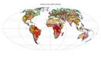
Other Global Soil Maps and Databases
- World soil resources map

Since 1995 collaborative efforts have been made between FAO, UNEP, JRC, IIASA and ISRIC World Soil Information to make regional updates of the FAO/UNESCO soil map of the world, notably under the SOTER (Soil and Terrain Database) program. A first revised global product (The Harmonized World Soil Database) was published in 2006 at a resolution of 1km. Recent efforts focus on using Digital Soil Mapping techniques (mapping soil properties continuously rather than soil associations with their related soil properties). A first revised global product made in this way may be expected soon. Other global maps (WRB, Soil Regions and Zobler) are using the original FAO/UNESCO soil map as main source of information.
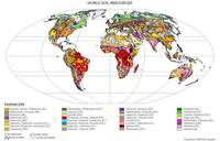
World Resource Base map
- World soil resources maps
The World Resource Base Map of World Soil Resources is available at 1:25 000 000 scale. This is the most general digital map of the World's soils, now using the international standard soil classification WRB. Available as a graphic or digital coverage.
World Soil Regions
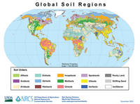
- Global Soil Regions Map
This map is based on the FAO-UNESCO Soil Map of the World but uses the USDA Soil Taxonomy.
The Zobler World Dataset (1 degree resolution)
The Zobler "World Soil File for Global Climate Modelling" shows the global distribution of soil types, including data for dominant soil units (classification of soil types), slope classes, soil texture classes and soil phases. These have been generalized from the FAO Soil Map of the World (FAO, 1974) and the Matthews Vegetation data (1984) into one-degree square latitude/longitude grid cells, using a dot grid overlay technique to determine the largest map unit of each one-degree cell. The data are only suitable for very large-area studies such as climate research with GCM.