![]()
![]()
![]()
by BRUNO RHODY
BRUNO RHODY, Dipl. Ing. (Forestry), is on the staff of the Institute for Forestry Research, Birmensdorf, Zurich, Switzerland.
The text wad revised by E. J. Gartner.
With particular reference to the Wild B8 Aviograph stereoplotter
IN FORESTRY the simplest methods are often used for compiling information from aerial photographs. The result is that photointerpretation is more stressed than photogrammetry itself, and that photo interpretation for forestry purposes has been developed into a highly specialized branch of classic photogrammetry. In discussions among foresters on the introduction of technical aids it has often been said that, during the initial period, complicated instruments and sophisticated evaluation methods should not be adopted, and, in consequence, the use of stereoplotting instruments for forestry purposes was not considered for a long time.
Due to increasingly intense forest management and the introduction of sampling methods into forest inventory, growing attention is now being attached to more accurate knowledge of the stand area and its classification. A comprehensive and accurate assessment of areas according to the standards of cadastral surveys is also being requested now by many authorities for forest areas. In such cases the simple methods of measurement, such as those used in photointerpretation, are insufficient, and the use of stereoplotting instruments becomes necessary. Use of stereoplotting instruments is particularly necessary in those countries whore completely new surveys of forests must be carried out or where accurate forest maps are required in view of difficult terrain, intensive management or complicated silvicultural conditions.
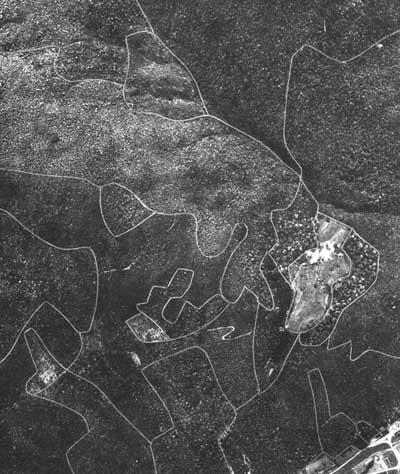
In topographic mapping from aerial photographs one is mainly concerned with plotting objects with definite outlines. In interpretation for forestry purposes, however, it is the gradation of the gray tones and the differences in structure and texture in their manifold combinations and interrelationships that are of special interest. While the topographer must see the picture in its abstract form, the interest of the forester lies in the natural aspect of the forest as seen in the photograph. A further characteristic of photointerpretation of forest areas is the difficulty of type classification within forest stands. Due to the layerwise structure of forestry stands it is often difficult to assess the distance between the main canopy and the ground. These aspects, so important for forest mapping, can hardly be assessed correctly by a surveyor or a photogrammetrist.
Experience has shown that it is constantly necessary to obtain decisions requiring professional training or consultation with the interpreters during the plotting process. It appears that it is hardly possible or efficient to separate interpretation and plotting, in particular if difficult silvicultural conditions prevail in the area under consideration. Forestry agencies would therefore be well advised to purchase their own plotting instruments and to carry out forest photointerpretation and mapping with their own staff.
In many cases forest inventory offices, larger forest services, and experiment and research stations may consider the purchase of a plotting instrument. Where new surveys of large forest areas must be made, such as in countries outside Europe or in tropical regions, the purchase of a plotting instrument is particularly important. If the agency concerned cannot make full use of the equipment, it might be possible to hire it out to other agencies from time to time when not in use.
Which stereoplotters should be recommended for purchase by forestry agencies?
A discussion of the details of plotting instruments is not the purpose of this paper: only the applications to forestry will be discussed. Under the conditions encountered in central Europe, the possible enlargement ratio from photo scale to plotting scale, is of some importance. Forest maps used in that region are usually of the relatively large scales of 1:5,000 and 1:10,000 in order to show forest conditions in sufficient detail.
On the other hand, the negative scale must be chosen as small as possible for economic reasons. In addition, low altitude photo flights are not possible for mountain forests, since the mountain slopes extend above the tree line. For intensively managed forests, the limit for interpretation is already reached at 1:20,000; smaller scales are not suitable. These considerations show that the plotter must have an enlargement ratio of 1:4 for forestry purposes. Plotters with approximate solutions, so-called third-order plotters, do not permit this enlargement from photographs to map.
A further significant factor of photointerpretation in forestry is the measurement of height. It is not only important to have direct readings of heights in meters or feet, but also the height range of the plotter must have sufficient amplitude, since even on completely flat terrain the tree heights can vary by up to 40 meters owing to stand differences. Height determination is especially important in dealing with mountain forests. In the case of the third-order plotters, the Z range is at most 25 percent of the flying height. This is not sufficient for interpretation of mountain forest areas.
Until now the question of suitability of plotters for forest type identification has not received much attention. Only good illumination and use of diapositives allow the interpretation of the subtle tone contrasts which express forest composition. For scanning such fine differences in the stands and for delineating their boundaries, clear measuring marks are needed in the plotter, These needs are only satisfied by very well-defined measuring marks which, however, should not be too small.
The accuracy requirements for forestry plotters is a much discussed subject. In principle, accuracy limits should always be determined in accordance with the problem to be investigated and the results required. For forestry purposes accuracy specifications should not be too rigid. When using approximate-solution plotters the biggest source of error is tilt.
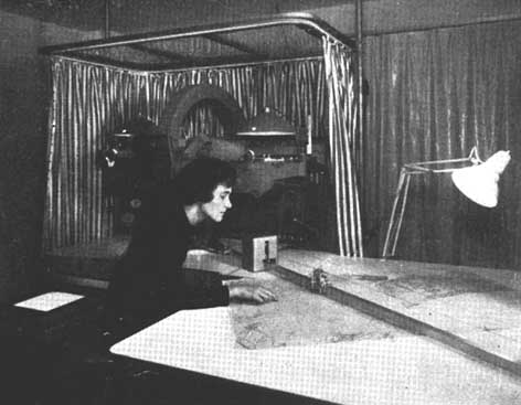
Many of the requirements for photointerpretation in forestry are met most satisfactorily by high order stereoplotters. On the other hand, approximate-solution plotters do not fulfill all these requirements, particularly if photographs of mountainous forest areas have to be interpreted. Until recently there was a gap between simple plotters and the autographs. In the past, stereoplotters could only be purchased by forestry agencies in exceptional cases because of their high price. However, the Wild Heerbrugg Company has now developed a simple stereoplotter, the B8 Aviograph, which closes this gap.
By comparison with the approximate-solution plotters, the most significant photogrammetric advantage of the B8 Aviograph lies in the exact geometrical reconstruction in the instrument of the bundles of rays as at the instant of exposure of the photographs. This makes it possible to convert exactly the central projection into an orthogonal projection, so providing for accurate plotting even of mountainous areas.
Another advantage of this plotter is that mapping can be carried out simultaneously on two scales: one at model scale, the other on a side table at the mapping scale required. A control plotting thus develops directly in front of the operator, who can immediately introduce important interpretation symbols. The pantograph plotting on the side table remains therefore as a clean map of the usually rather complicated composition of forest areas. In addition, the operator is not distracted from the plotting work, which is especially important when the operator has less experience as is often the cage when plotting is carried out by forestry agencies with their own staff.
Another convenient feature of the B8 is the freehand movement of the floating mark, and the method of control of the height setting on the tracing stand. This method of scanning is easier for beginners than that used in autographs, which must be operated by means of two handwheels and a foot disk.
Finally, the bright illumination of the pictures, the wide field of view and the great enlargement of the area being interpreted are all factors which favor the B8. Interpretation of and plotting from color photographs is another promising aspect of the B8 for its use in forestry work. This type of work cannot be carried out by projection-type plotters.
Reference has already been made to the enlargement ratio. In the B8 Aviograph the ratio from picture scale to model scale is 1:2; and from model scale to plotting scale it is 1:2.5 using the linear pantograph and side table, thus providing for an enlargement of 1:5 from pictures to plotting. In this way, forestry requirements are fully met.
Recording photointerpretation results on the photographs and their transfer to the map are important aspects of photointerpretation in forestry.
For photointerpretation of central European forests a great number of forest types and condition classes have to be distinguished. This is a result of intensive forest management. But also in other regions of the world forests are more or less differentiated due to geological, topographical or anthropogeographical influences.
The photointerpretation of a spatial model is carried out by delineating with colored ink forest types and condition classes and other important features of the area. This important preparatory work for the plotting can be done either on paper prints, or on diapositives, or - in special cases - even on the original negatives.
The advantages and disadvantages of using paper copies, film material or plates should be examined for each case. There is no dispute that interpretation on diapositives is superior to that con other material because in forest areas many details are obscured by shade. They can only be recognized (and identified) by examination of a stereopair of diapositives. Negatives also offer the advantage of possible recognition of details, but the light-shade relationships are inverted and a mental conversion is therefore necessary. This is particularly difficult if coniferous and broadleaf stands are mixed. It can also lead to errors in interpretation.
Many research and experimental projects have shown that it is of great advantage if the two operations of photointerpretation and stereoplotting can be combined to become the duty of one person only. In many forestry projects the separation of photointerpretation and plotting results in a division of work, because they are usually carried out in different places. It is therefore desirable that diapositives are ordered when specifications for an aerial photography contract are drawn up. These diapositives can be interpreted with a stereoscope if they are put on an illuminated table. The results can be marked in colored transparent ink either directly on the diapositives or on clear overlays which are forwarded to the plotting office.
When using plotting instruments for forest mapping projects the instruction manual for the operator deserves special attention because the instrument is used in this case for nontopographical purposes, and plotting is therefore not carried out by professional photogrammetrists. An explanation of the terms used in photogrammetry is therefore very important in such a manual.
For the B8, Wild has made every effort to prepare a handbook which does not assume a previous knowledge of technical literature on photogrammetry. Another helpful feature is that the mathematical computations for orientation of the model are presented in graphical form; for the B8 by convenient tables.
Since the accuracy requirements for forestry purposes are not so rigid, existing up-to-date maps can be used for the absolute orientation of the photographs. When new photography is to be taken for forestry purposes, it is important that air-visible pass points be signalized before the flight takes place. If no control points exist in a forest, it is recommended that new points be established and kept cleared. Such action will provide sufficiently accurate control points so that there is no need, later on, to establish special signals.
In many territories outside Europe, where an intensive survey is lacking, the pass points must be determined by aerial triangulation. In such cases, high-altitude photography is needed for this purpose and low-altitude photographs are to be taken for forest photointerpretation.
Finally, mention should be made of the accuracy requirements for height measurements in photointerpretation for forestry purposes (Table 1).
The maximum accuracy usually achieved for ground measurements of tree heights amounts to 10 percent for dense stands and to 2.5 percent for isolated standing trees. Consequently height accuracy of pass points should correspond to these values. If the trigonometrical points and contours on the maps conform with these requirements, they may be used for the absolute orientation. However, since there are not always enough of these points, it will be necessary to use other good map points. For example, the height accuracy specifications of the Swiss general cadastral map series at 1:10,000 and the Swiss national map series at 1:50,000 are within these tolerances. If the height errors of good map points are compared with these values, it is found that the tolerances are 1.5 meters for the topographical cadastral sheets at 1:10,000, 1.5 meters for the 1:25,000 and 2 meters for the 1:50,000 national maps. Therefore, all well-defined points in these maps can be used as height pass points for the purposes of forest mapping.
The requirements regarding positional accuracy in forest mapping depend primarily on the possibilities of identifying the boundaries of forest photointerpretation units. Difficulties in defining the exact edges of stands result from the changing width of the strip between the projection of the crown of the tree and its foot and from the structure of the forest. This indefinite strip is about 5 meters wide in the most favorable case with young and homogeneous stands, and widens with increasing age: 5 meters can therefore be accepted as the upper limit of positional accuracy for forest mapping. This value is satisfied by the general cadastral map with 3 meters' tolerance and by the 1:25,000 national map 5 meters' tolerance. The 1:50,000 national map, with its 10 meters' tolerance, however, exceeds most of the accuracy requirements for forest mapping. The 1:25,000 national map can therefore still be used as control for the absolute orientation when maps are prepared for forestry purposes.
A further peculiarity of forest stereomapping results from the use of low-altitude photography which is necessary in special cases for intensive photointerpretation.
TABLE 1. - ACCURACY REQUIREMENTS FOR TREE HEIGHT MEASUREMENTS (in relation to focal length (f), flying altitude above ground level (H), and minimum size of interpretation units)
|
Photo scales |
1:5,000 |
1:10,000 |
1:15,000 |
1:20,000 |
|
Interpretable forest units |
Single trees |
Smallest survival group |
Economic tree groups |
Stands |
|
Error, as % of height determination |
2.5 |
5 |
7.5 |
10 |
|
Maximum tree height, in meters |
40 |
40 |
40 |
40 |
|
Height error (H.E.), in meters |
1 |
2 |
3 |
4 |
|
With f = 152 mm = 6 in. | ||||
|
H, in meters |
760 |
1 520 |
2 280 |
3 040 |
|
H, in feet |
2 506 |
5 000 |
7 500 |
10 000 |
|
H.E. in ‰ of H |
1.3 |
1.3 |
1.3 |
1.3 |
|
With 210 mm 8 ¼, in. | ||||
|
H, in meters |
1 050 |
2 100 |
3 150 |
4 200 |
|
H, in feet |
3 500 |
7 000 |
10 600 |
14 000 |
|
H.E. in ‰ of H |
0.95 |
0.95 |
0.95 |
0.95 |
|
With f = 115 mm 4 ½ in. | ||||
|
H, in meters |
575 |
1 150 |
1 725 |
2 300 |
|
H, in feet |
1 900 |
3 800 |
5 800 |
7 600 |
|
H.E. in ‰ of H |
1.75 |
1.75 |
1.75 |
1.75 |
In mountainous areas it sometimes happens that the terrain height differences in one model are so large that they exceed the height range of the plotting instruments.. Such models must then be plotted in stages using different model scales. In exceptional cases it might be helpful to plot at an arbitrary scale which will call for conversion of the elevations read. For stage-by-stage work, sufficient pass points must be available in each height layer.
Since extreme height ranges are no rarity in forest mapping from large-scale photographs, investigations into the instrumental possibilities of the B8 Aviograph were undertaken together with O. Wey and R. Scholl of Wild Heerbrugg. The most unfavorable case occurs when a relative orientation is not possible in one step because of the extreme height differences in the whole model; it might happen that only a part of the model area lies within the Z range of the plotter. In this case the relative orientation can only be made by changing the base. Since in the Aviograph we have a so-called spatial base, the relative orientation is not disturbed by a change of the base. For the correction of w for example, the base can be altered until the floating mark can be set with the height drum on parts of the model which would otherwise be outside the ranges. It is important that in this case the model slope is in the direction of the base or perpendicular to it. The topographical forms are usually such that the forest stretches along both hillsides of a valley. For forest photography, the flight line should therefore follow the centerline of each wooded slope and go parallel to the valley. With this disposition, a stereomodel includes only one side of the valley.
The quickest way of achieving the relative orientation is to eliminate first the tilt and afterward the j parallax in the upper part of the model and the w parallax in the lower part of the model.
Finally, the much discussed problem of affine restitution should be mentioned since this is important in forest mapping.
When original photographs without transformation for forming an affine model are used, only approximations are possible, which lie between certain limits of error. Since the accuracies required for forestry purposes are not so high, approximations in stereomapping can most of the time satisfy the requirements.
The problem of affine restitution has been discussed in scientific journals on various occasions in recent years. These discussions have shown that the use of affine methods for restitution may be justified under certain circumstances. Mention is made here particularly of the important question of plotting with a shorter focal length (f), which causes compression of the model and can therefore bring certain advantages in plotting mountainous areas. The use of longer focal lengths for forest photography is important for intensive photointerpretation which requires as vertical a view of the area as possible.
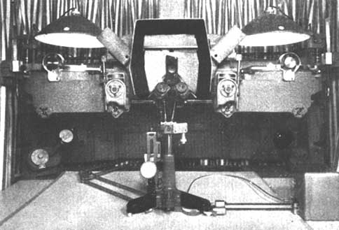
FIGURE 4. - Detailed view of the Aviograph B8.
In the case in hand, investigations were made with photographs taken with the Aviator f/4 (f = 210 millimeters). Since this focal length cannot be used in the B8, such photographs must be restituted by affinity. In restituting with a shorter focal length, the relationship of the elevation scale to the planimetry scale changes as the plotting focal length to the focal length of the photographic camera. According to the investigations by R. Finsterwalder (published in Bildmessung und Luftbildwesen, Karlsruhe, Heft 4, 31 Jahrgang), the model errors increase linearly with the factor (k), which is given by the ratio between the plotting focal length and the camera focal length. For the plotting focal length of (f) = 152 millimeters and the camera focal length of (f) = 210 millimeters with a factor (k) of 0.72, the errors in position and height caused by model deformations resulting from inclinations of the photographs would amount to 0.17 millimeter in position at a 3 degree tilt and 0.54 per thousand of (H) with a terrain height difference of 20 percent of the flight height.
The positional errors arising from affine restitution are less important from the forester's point of view and he within the required accuracies, while the height errors exceed them only in extreme cases. The investigation carried out with the B8 Aviograph with forest photographs taken with a longer focal length have shown that there can be no objection to the use of affine methods in forestry, provided the tilts are less than 5 degrees and the enlargement ratio (k) of plotting focal length to photographic focal length does not exceed the factor 1.5.
In affine plotting of models with 25 percent height differences and more, residual parallaxes are present which cannot be eliminated in the relative orientation. With very difficult orographic conditions in the model it has been found convenient to group average terrain slopes and to orient and plot the model in stages. When using affine methods for plotting from forest photographs, the use of such approximate methods cannot be avoided in extreme cases.
In summing up, it can be stated that the Aviograph is suitable for intensive forest interpretation and mapping both with normal photographic conditions within the technical ranges and when using affine methods.
|
· Four Special Fund projects are phasing out in 1965 (Chile, Honduras, Mexico, Turkey), and two new projects, in Nepal and Panama, have been approved by the Governing Council at its midyear session. The FAO Forestry and Forest Products Division will be operating 34 projects by the second half of 1965. · Fuat Adali (Turkey), formerly forestry adviser, has been appointed FAO Country Representative in Iran. · Special arrangements have been made between FAO and the governments of Sweden, Denmark, Norway, Netherlands and the Federal Republic of Germany, whereby these governments provide and finance trained but relatively junior foresters to serve for one or two years with FAO field staff. The juniors thus widen their own experience, and in turn usefully assist the work of the FAO projects. At present 30 such "associate experts" are serving with FAO. A number of United States Peace Corps personnel are also working in association with FAO forestry projects. |
![]()
![]()
![]()