![]()
![]()
![]()
R.G.M. WILLAN
R.G.M. WILLAN was Chief Conservator of Forests, Nepal, from 1962 to 1967, on an FAO operational executive assignment (United Nations Development Program).
FOR MANY YEARS the highest mountain in the world remained unconquered. During the 1920s and 1930s numerous expeditions attempted to climb the huge peak called Mount Everest by English geographers but without success; at last in 1953 the news was flashed to the world that the New Zealander Edmund Hillary and the Sherpa Tenzing Norgay had set foot on the summit.
Long before this, however, members of the various climbing expeditions in the Himalayas had become acquainted with the Sherpas who live in the high country below Everest, a people of Tibetan origin who are believed to have crossed the high passes of the Himalayas into the region now known as Khumbu about two centuries ago.
Used as they are to a hard life at high altitudes, the Sherpas offered their services as porters for the climbing expeditions and soon proved their exceptional stamina and cheerfulness under the most exacting conditions - so much so that without their help in carrying the expeditions' tents, food and equipment to the high altitude assault camps the successful conquest of Everest and other peaks would hardly have been possible. These Sherpas were recruited at Darjeeling in India, since entry by foreigners into Nepal was forbidden and all the early Everest expeditions had in fact to get permission to cross into Tibet and approach the mountain from the north. By 1951, however, with the downfall of the regime of the Rana prime ministers, Nepal was no longer a closed country, and permission was given to the expeditions to approach Everest from the south, from Khumbu the Sherpas' own homeland, which at last became known to people in the outside world. Even so, until the last few years almost the only people to visit Khumbu have been members of climbing expeditions, with a few botanists and geographers. But since 1965, with the construction of a small landing strip for light aircraft at Lukla by Sir Edmund Hillary and members of his recent expeditions, it has been possible for visitors to avoid the tedious two-week journey on foot from Katmandu and fly to Lukla in the valley of the Dudh Kosi, a day's journey from Namche Bazaar and Khumjung, the main villages of Khumbu.
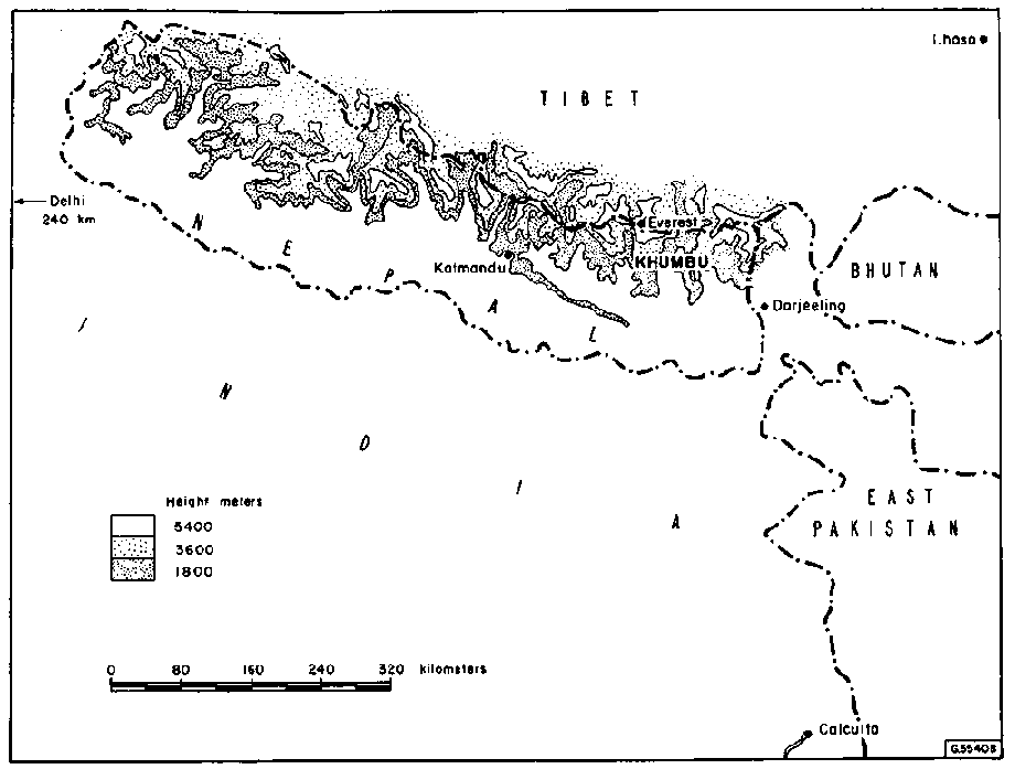
Khumbu lies below Mount Everest, called by the Sherpas Chomolongma, literally "Snow Mother of the World," and known elsewhere in Nepal as Sagarmatha. From the Khumbu glacier on Everest flows the Imja. This joins the Dudh Kosi and the Bhote Kosi, rising below other glaciers to form the Dudh Kosi which runs southward from below Namche Bazaar and eventually into the Sun Kosi southwest of Okhaldhunga. The Dudh Kosi is so called because of the milky whiteness of its water which contains lime in suspension from the limestone rocks below the mountain glaciers where it rises. The water of the Imja Khola is also milky in appearance but has a beautiful shade of green from the melting ice of the Khumbu glacier.
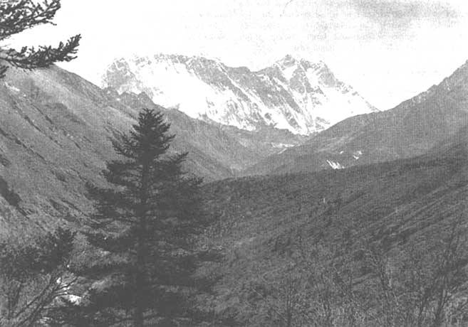
These mountain torrents have carved out the stupendous valleys which are such a feature of Khumbu and whose sides are covered with forests of pine, fir and birch up to the tree line at about 4,100 meters (13,500 feet) above sea level. Towering above these valleys are the great mountain peaks, all over 6,000 meters (20,000 feet) in height. To the east are Tramserku and Kangtega, above Thyangboche. To the west above Namche Bazaar are Numbur, Karyolung, Teng Kangpoche and Kongde Ri, while further north are Taweche and the beautiful spire of Ama Dablam, on each side of the Imja Khola. To the north is the huge Everest massif with its guardian wall of Lhotse and Nuptse.
The deep valley of the Dudh Kosi must be followed by all travelers to Khumbu, and one has to climb out of this valley to reach Namche Bazaar. From there tracks lead to the villages of Khumjung, Thame, Phorche and Pangboche, and to Thyangboche monastery, all of which lie below the great peaks at the upper limit of tree growth. The whole of this region at 3,600 to 4,500 meters (12,000 to 15,000 feet) is known as Khumbu. The region of Pharak, at 2,400 to 2,700 meters (8,000 to 9,000 feet), flanks the gorge of the Dudh Kosi, and to the southwest of this and at a generally lower altitude is the Solu region.
The main features of Khumbu are the great peaks, with their glaciers, icefalls and snowfields; below these are the glacial moraines, steep cliffs and rocky slopes, covered here and there with low alpine vegetation, and the deep forest-covered valley of the Dudh Kosi. It is on the bare upper slopes that the Sherpa villages are to be found. Above the tree line at 4,100 meters (13,500 feet) there are a few small villages which are only inhabited during the summer months, and where it is possible to grow potatoes.
Khumbu is famous throughout the world on account of the stories brought back by the Everest climbers and others of that mythical animal the "yeti" - called "the abominable snowman" by Europeans and now generally considered to be a species of bear. A few other wild animals do live in this high region, namely musk deer and bears, and also perhaps the serow and the tahr, while wolves are occasionally seen. In contrast to the few animal species, bird life is abundant and varied, ranging from the huge lammergeier or bearded vulture to the beautiful monal pheasant, the Tibetan raven, the snow cock at the highest altitude, the snow pigeon, the chough, and a great variety of small birds.
With regard to tourism, it is already clear that Khumbu will be visited by increasing numbers of tourists from now on, drawn by the stupendous scenery to one of the world's finest and so far unspoiled natural areas. The Sherpas are a :friendly and hospitable people and the spending of money by tourists would certainly help the precarious local economy, although one cannot but express the hope that Khumbu will be spared by its relative inaccessibility from the worst. aspects of modern tourism.
The main diet of the Sherpas is potatoes which, with barley, are grown in village fields walled with stone to keep out grazing animals. Barley is used for brewing beer called chang and the flour is also mixed with water or with tea to make tsampa. The Sherpas are much addicted to drinking Tibetan tea, which is made with butter and salt and is very sustaining in the cold climate of Khumbu.
Cultivation of the light powdery soil is done with a small wooden plow and roller pulled by a team of men or women, but recently some attempts have been made to use zopkio for this.1 Yaks are used as transport animals and both they and zopkio provide milk.
1Zopkio or zo, called chauris in other parts of the Nepal Himalaya, are a cross between a yak and a cow and can live at slightly lower altitudes than yaks. They also give more milk.
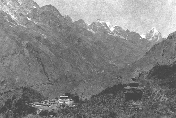
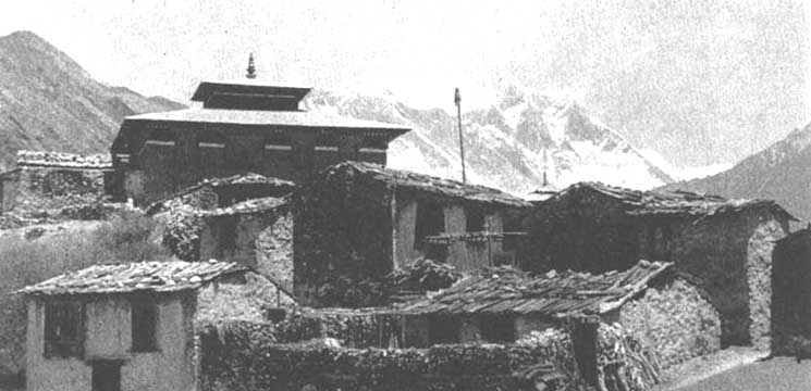
The Sherpas brought their religion, lamaistic Buddhism, from Tibet, and today there are several monasteries or gombas in Khumjung. Thyangboche, the best known, is perched on a wooded spur above the valley of the Imja Khola and facing Everest.
In addition to the Sherpas' ability to live under harsh climatic conditions at high altitudes, perhaps the most interesting feature is the strong sense of community life in Khumbu, and this is reflected in the system of control over the cutting of trees in the forests which was evolved by the Sherpas themselves, without imposition of control by any government agency. Certain members of the community were designated shingo naua, whose function was to report any person who cut trees without permission having been obtained from the village council. Fines were imposed for wrongdoing and were paid in the form of beer (chang). This self-imposed system of control has helped to protect the forests of Khumbu from haphazard and destructive cutting. The comparatively good condition of the forests is undoubtedly due to the ability of the Sherpas to prevent the destruction of a natural asset on which their whole livelihood depends. Fürer-Haimendorf, in his book The Sherpas of Nepal, says:
"Compared with the forests of lower and climatically more favored regions where peasants of Chetri, Brahman and Newar stock have in recent generations wrought enormous devastation, the forests of Khumbu are on the whole in good condition. This is mainly due to an efficient system of checks and controls developed and administered by a society which combines strong civic sense with a system of investing individuals with authority without enabling them to tyrannize their fellow-villagers."2
2 Fürer-Haimendorf, The Sherpas of Nepal, H. Murray, London. 1964.
The forests of Khumbu do not appear to have been described previously in print but they are not only extensive and of great interest but are of great importance to the Sherpas. The following is not a description of their botanical composition but an account of the forest seen during a recent journey between Lukla in the valley of the Dudh Kosi at about 2,700 meters (9,000 feet) and Pheriche, which is above the tree line at about 4,300 meters (14,000 feet).
Lukla and the nearby village of Chaunrikharkar are situated on a shelf above the Dudh Kosi, which here Bows in a deep gorge. This shelf is cultivated, and in May the barley crop was beginning to ripen, while the potato crop was well grown. On the mountainsides above and below this shelf is well-developed mixed hardwood forest, containing species of Quercus, Ulmus, Acer, Betula, Corylus, Salix, Prunus and Rhododendron with scattered Tsuga dumosa higher up, and here and there a few Pinus wallichiana. On the mountainside above Chaunrikharkar there is a grove of pure Quercus semicarpifolia. As one travels northward up the valley one passes through areas of scrub in which Rhododendron arboreum occurs, but here the forest has been destroyed in the past and many trees are now subjected to hacking and lopping, particularly the oaks. All this area appears to get more rain and to be far moister than higher up the valley in Khumbu.
Further on the path drops to the Dudh Kosi, which is crossed by a new timber bridge designed and built by Hillary's party, and here one enters the zone of kail (Pinus wallichiana), which continues on both sides of the valley right up to Namche Bazaar and further up the Dudh Kosi valley to just below Thyangboche. The pine forest contains few other species, though occasional hemlocks (Tsuga dumosa) occur, and at one place one or two firs (Abies spectabilis) are to be seen, but the Tsuga, soon disappears and fir forest replaces the pine on the upper slopes of the valley, where it merges into juniper (Juniperus indica) and birch (Betula utilis) forest at about 3,700 meters (12,000 feet).
VALUE OF THE PINE FOREST
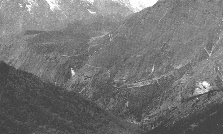
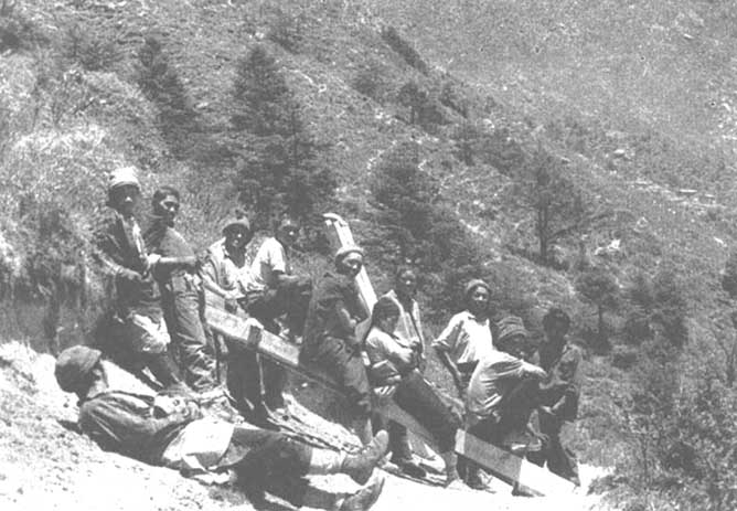
The pine forest of the Dudh Kosi valley is interesting and important, since it is extensive and constitutes a supply of good timber for the small villages in the valley and for Namche Bazaar itself. It has been used for the schools and bridges built by Hillary's party, and at the time of the author's visit pine timber for the hospital at Kunde near Khumjung was being carried up to the village from the forest where it had been cut and sawn near the junction of the Imja Khola and the Dudh Kosi below Thyangboche (Figure 6).
A noticeable feature of the Dudh Kosi pine forest is that it consists mostly of young trees and that trees of large size do not occur, even away from the path. This may perhaps be due to the fact that all the large trees have been cut in past years for building construction, or possibly that the pines are now colonizing areas which were devastated by fires some time ago.
This tree regenerates abundantly and easily if given the chance, and all along the river there are numerous patches of young growth.
At present little serious damage seems to have occurred, though here and there trees have been wastefully cut and hacked, but the worst damage to be seen is the cutting of resinous wood. out of the stems for use as torches. This is particularly noticeable just below Namche Bazaar where there is an open forest of pine clearly in a very poor state where almost every tree has been badly hacked for torchwood. Numbers of trees have been either killed or badly scorched by fires which have occurred near the village.
Namche Bazaar, at about 3,500 meters (11,500 feet), is situated in a bare and bleak spot at the head of a small valley above the Bhote Kosi; apart from a few willows there are no trees anywhere in the village. On the other side of the Bhote Kosi, however, there is a forest of fir, juniper and birch, from which the village obtains its supplies of firewood. Further up this valley tree growth continues as far as the village of Thame. Firewood was said to be very expensive at Namche Bazaar and Khumjung, no doubt because of its scarcity and the fact that it now has to be carried for long distances from forest to village.
Above the village the hillside is bare and has every appearance of being badly overgrazed by yaks and zopkio, resulting in erosion and loss of soil. However, as one tops the ridge and. begins the descent to Khumjung, the hillsides are covered with a low woodland of birch and fir obviously very much utilized for firewood and timber but still able to persist in spite of this. Khumjung itself, together with Kunde situated below the great rocky peak of Khumbui Yul Lla at about 3,780 meters (12,400 feet), lies in a bare and heavily-grazed valley, which is surrounded by this much-exploited forest of fir and birch.
From Namche Bazaar, the direct path to Thyangboche runs for some distance along a bare hillside and scattered birch trees only begin to appear where it joins the path to Khumjung and Trashinga. Below, in the deep valley of the Dudh Kosi, there are scattered pines, but on the far side of the valley are extensive forests of pine and fir. It is noticeable that part of this forest has been destroyed by fire in the past since there are many dead trees.
Continuing along the path to Trashinga village and Thyangboche, one drops down to the Dudh Kosi and here there is a well-grown pine forest, again of fairly young trees. Beyond the bridge over the torrent there is an extensive and well-developed birch forest on the north-facing slopes of the valley of the Phunki Drangka which rises in the Kangtega glacier. On the south-facing slopes of the ridge on which Thyangboche is situated there is an almost pure forest of fir. Rhododendron arboreum is common on this slope under the firs, but is replaced by Rhododendron campanulatum further up the ridge. At its summit, the ridge is rather bare of vegetation, with only scattered firs and junipers, and appears to be rather heavily grazed by chauris. The altitude at Thyangboche is about 3,800 meters (12,500 feet), which is very near the tree line, so that the surrounding forest is very exposed and the fir and juniper trees are rather short. However, on the north side of the ridge facing the valley of the Imja Khola and Everest there is well-developed birch forest containing scattered but numerous firs of good form and growth. This forest continues down into the valley near the villages of Devuche, Milinggo and Changmitang, with junipers becoming numerous until the bridge over the Imja Khola is reached, near Pangboche.
It is of interest to note that in the birch forest below the monastery there are the remains of fir stumps of much bigger diameter than any of the trees which are growing there now, and these must have been trees of considerable size. It would seem that these trees were felled and used for building the monastery some 40 years ago, or for rebuilding it after the earthquake in 1934. Clearly the felling of these trees was done in a careful and selective manner, without damaging the forest. An interesting feature is the abundance of seedlings and saplings of all the various species, such as fir, juniper, birch, Rhododendron, and others. This is a sign of considerable vigor unusual in high altitude forests, where trees frequently have a hard struggle to persist at all. Together with the capacity of Pinus wallichiana to regenerate so easily, this is a matter of the greatest significance for the Sherpas of Khumbu, since it will facilitate the introduction of simple systems of forest management and silviculture which can ensure their wood supplies for all time.
Beyond the bridge over the Imja Khola the hillside is almost bare of trees except for an occasional low juniper, but on the eastern bank of the stream the birch reappears in the form of a long strip which covers the steep bank from almost opposite Pangboche to Tsuro Og. This is the highest birch wood in Khumbu and the last tree growth in the valley. The altitude is about 4,100 meters (13,500 feet). The interesting feature of Pangboche village, which lies at about 4,000 meters (13,000 feet), is the sturdy growth of junipers within the village itself. These trees give considerable protection the cold winds and provide some branch-wood and stems for local use.
The rest of the valley of the Imja Khola is treeless and bleak. From the last birch wood up to Dingboche at 4,300 meters (14,000 feet) there is a strip of low scrub consisting of dwarf willow, Rhododendron, and occasional dwarf junipers (Juniperus recurva). The summer village of Phulung Karpo lies above this scrub, and the surrounding hillsides and the upper valley are covered with short alpine plants and grasses which provide important summer pasturage for yaks. All this part of Khumbu has an exceedingly severe climate. The soil is frozen hard from October to April and is covered by periodic snowfalls in spring and autumn. It is only during the brief summer months that it is possible to grow potatoes in the tiny walled-in fields, and for the yaks to graze on the high pastures. In the middle of May there was nightly ground frost at Thyangboche, and higher up the valley the wind was bitterly cold, even at midday. -But the weather was cloudless and the meadows were covered with Primula denticulata in full bloom, while in tile forest pale lilac Rhododendron campanulatum and a yellow-flowered kind were in flower, as on the treeless slopes above the monastery was the short, sweetly-scented Rhododendron anthopoqon.
The forest types in Khumbu appear to be typical of the eastern mountains of Nepal.
In the lower valleys one finds that there is well-developed broadleaved. forest, of which Quercus, Acer and Rhododendron are characteristic. This merges into Tsuga forest on the moister southern aspects and into Pinus on the drier north-facing slopes. Above this are forests of Abies, with EL characteristic understory of Rhododendron campanulatum and several other species. At the upper limits of the Abies forest Juniperus and Betula appear until just below the tree line Betula forms an almost pure woodland. Above this only prostrate Juniperus and dwarf Salix are to be found. These forests are, therefore, different in composition to those in the drier central and western Nepal Himalaya, where such species as Cupressus torulosa, Picea smithiana and Cedrus deodara occur. Larix griffithii does not seem to occur at all in Khumbu.
Wood and timber are obviously essential requirements for living in Khumbu. Timber, whether fir, pine or juniper, from the nearby forests is used in the construction of all Sherpa houses, which are roofed with wooden shingles. Obviously the houses have to be solidly constructed to stand the exposure and to keep out the cold at these high altitudes. Similarly the people must have an abundant and accessible supply of firewood for heating and cooking. This is obtained from the birch woods which are such a feature of Khumbu.
Newer and no less important uses of sawn timber can now be seen in the modern hospital, schools and bridges already mentioned. Without a local supply of suitable timber, such developments would not have been possible.
Three dangers to the forests of Khumbu are excessive cutting, fire and erosion.
EXCESSIVE AND WASTEFUL CUTTING
Although the position can be regarded as reasonably good at the moment, this danger is always present in any area where, through lack of knowledge, education and organization, the community is unaware of the necessity of preventing excessive and wasteful cutting, and once such abuses start and are not checked the inevitable result is cumulative destruction. This is happening to such an extent in the midlands of Nepal that all possible steps should be taken to avoid the same thing happening in Khumbu. The Forest Department can give practical assistance by drawing up a simple set of rules for the felling of trees according to basic silvicultural practices, and by designating the areas in which felling should be done under rotation. This would be real and practical forestry which the Sherpas could easily understand and practice themselves with the local council merely insisting on a few necessary protective measures, which could be enforced by locally-appointed shingo naua or forest guards.
FIRE
There are several places where trees and vegetation on steep slopes have been destroyed, either by intentional or by careless lighting of fires, The inevitable result of this will be baring of the soil and erosion.
Nothing whatsoever can be gained by burning in Khumbu, so the lighting of fires in the forests or on open hillsides should be totally prohibited by the local council, and at the same time the people should be taught the destructiveness of fires.
GRAZING AND EROSION
The Sherpas keep a considerable number of yaks and zopkio, on which to a great extent their economy depends. In summer the yaks are grazed on the high alpine pastures just below the snow line but they are too few in number to cause serious erosion. However, the zopkio are grazed in considerable numbers at lower altitudes and frequently in the forests, where the vegetation is trampled down and eaten, resulting in denudation and erosion. Since such overgrazing seems to be most prevalent round the villages, where severe erosion is noticeable, this is more a problem of animal husbandry and pasture improvement than of forestry. Such heavy grazing, however, makes the planting of trees near the villages difficult if not impossible and, if it is considered advisable and practicable to reforest bare land for production of firewood, grazing will have to be firmly controlled.
It is apparent that the Sherpas recognize the value of trees and forests, and realize that without them life in Khumbu would be well-nigh impossible. They have therefore protected the forests to a considerable extent from the abuses which have led and are still leading to their destruction and disappearance in other parts of the country.
The system of protection which has been described earlier in this article has however broken down to a large extent in recent years, and certain rules about the cutting of trees for use by the villagers are no longer enforced. As the forests are becoming more vulnerable, it is imperative that new rules for protection should now be devised and put into practice, and for this the assistance of the Government is needed.
The forest surrounding the Thyangboche monastery has been mentioned earlier. Its position accounts for its protection from haphazard cutting and hacking by local villagers, since it has been protected by the lames. The Head Lama, Rimpoche Nawang Tenzing Jangbu, accepted as a reincarnation of the lame who founded and built the monastery, is a man of exceptional charm and intelligence, and greatly interested in the preservation of the forests, the animals and birds in Khumbu. Since he is the spiritual leader of the Sherpa community and greatly respected and revered by them, his example and attitude to conservation have a considerable effect.
![]()
![]()
![]()