![]()
![]()
![]()
The methods used in this paper depend primarily upon the physical description of upwelling area and season. It was assumed that the biological zone of production was two and a half times wider than the apparent physical one. This ratio may differ in areas other than that off California; indeed that of Peru may be much wider. The radiocarbon estimates are probably good when sufficient are available. The zooplankton observations are vulnerable to excape, loss through the meshes and the irrelevant capture of algae. But the correspondence of other observations seem to justify the assumptions. The most important check is that 1 per cent of the primary production corresponds with 10 per cent of the secondary production - estimates which are independent. Lastly the estimates of third level stock off Peru are not very different from that made by Gulland (1968) for the anchoveta stock there. Despite the roughness of the methods used there appears to be a consistency in the results.
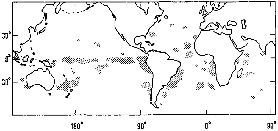
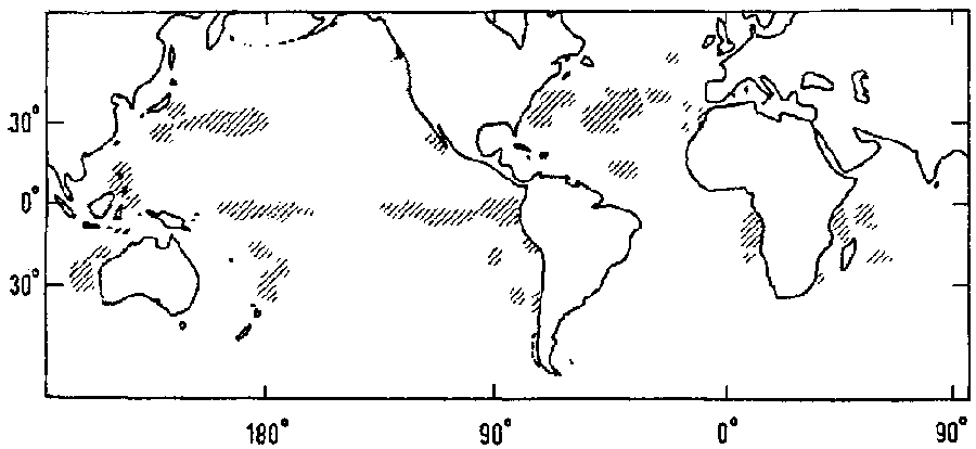
The areas of upwelling in the broad sense can be charted, but they can also be indicated indirectly. Figure 18 shows the positions of capture of sperm whales by Nantucket whalers from 1726 to 1919 (Townsend, 1935). It will be seen that the main upwelling areas, California, Peru, Benguela and Canary are indicated. That off northwest Australia is more noticeable than would be expected from other physical and biological evidence. The most striking area of capture is that along the Line in the Pacific in the South Equatorial Current. In the southern winter these areas remain as the Peru Oceanic Current divergence and that in the western ocean. The Madagascar Wedge appears on the chart (in the northern summer) and so does the divergence southeast of Ceylon. The New Guinea divergence can be seen as well as an indeterminate area between the Philippines, Borneo and the Celebes. The Canary Current extension in winter is noticeable and so are the northern divergences, particularly those in the Kuroshio extension in winter. The only anomaly on the chart is really the area in the Gulf Stream and central North Atlantic in summer; perhaps in the two areas there was a concentration of vessels coming from easterly or westerly into Nantucket. Absent are the Somali, South Arabia, Orissa and Vietnam upwellings.
Figure 18. Distribution of sperm whale catches from Nantucket 1726-1919, (Townsend, 1935);
Figure 18 (a). Northern summer
Figure 18 (b). Northern winter
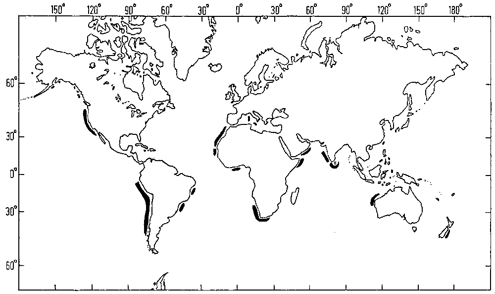
Another way of showing the world upwelling areas is in a chart Figure 19 of the phosphatic deposits (Tooms, 1967). All the main upwellings are shown even small ones like those off the Malabar coast and off the southern coast of Ceylon. The Guinea upwelling is shown and so is that off northwest Australia. The deposits off South Africa extend round the Cape of Good Hope to Cape Agulhas and beyond. It is known that upwelling can continue offshore round the Cape but it would be surprising to put it at the same level as that off the western coast of South Africa. The deposit off California suggests that the centre of upwellings is really between Cape Mendocino and Point Conception and that the present shift southward to Baja California is perhaps a climatic deviation (California, Department of Fish and Game, 1953). The equatorial system is not shown at all by this method, but the form of production cycle there has not the disbalanced nature needed to spill phosphorus on the seabed. Nothing is shown for the Indonesian area or the Caribbean, perhaps because the upwelling is less intense or nearer the steady state of the tropical ocean.
Figure 19. Distribution of phosphatic deposits (Tooms, 1967)
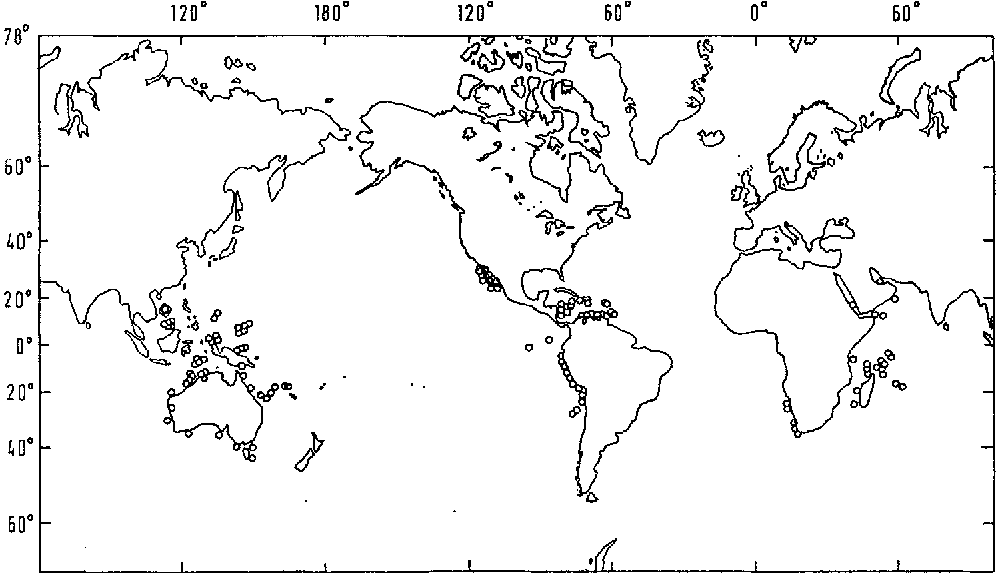
A third method of showing the upwelling areas is by charting the Guano Islands (Figure 20, adapted from Hutchinson, 1950). Islands are needed, but in Peru capes and points are used by the birds. The more important upwelling regions, Peru and Benguela, are clearly shown. The Somali and Southern Arabian ones are indicated and so are the Indonesian ones, particularly the Banda Sea, the New Guinea divergence, northwest Australia and the areas off Vietnam and Borneo. The Californian area is shown only off Baja California and in the Gulf of California although there are many islands to the north, particularly just south of Point Conception. There is no sign of guano islands in the Canary Current although islands are available. Perhaps, over a long period, the California and Canary Currents are not intense enough or are too variable to support the population of birds. A surprising point is the indication of upwelling in the Madagascar Wedge and off Venezuela. There are few guano islands in the Indian Ocean, but there are some on the south coast of Australia.
Figure 20. Distribution of guano islands (Hutchinson, 1950)
The nature of the upwelling process has been described physically, but not biologically. The vertical velocity has been estimated by a number of authors, but it has not been measured nor has it been related to biological production, save in one instance. In the Costa Rica Dome, Wyrtki (1964) has estimated the vertical velocity from a heat budget. The difference between the surface concentration of phosphate phosphorus and that below is raised by the upwelling velocity to give the daily use of phosphate. It is rather close to the daily carbon production as measured by the radiocarbon method. The surface value of phosphate is unbalanced in this sense, i.e. a greater proportion has been absorbed than regenerated and this proportion changes with distance from the line of upwelling and so phosphorus concentration declines offshore. But just as the temperate production cycle can be analyzed in its unbalanced state, so can that in an upwelling area. But the relationships between upwelling velocity, nutrient consumption, grazing and production need disentangling.
Apart from the theoretical work of Hidaka and Yoshida the study of upwelling has been in the first stage of exploration and description. There is a second stage in oceanographic research where a survey should be mounted in sufficient detail to allow a more analytical approach to be sustained. For such a survey an area can be defined by the zone of biological production in width and its homogeneous seasonal production in length (for example, one of the three areas off Western North America such as that from Point Conception to Baja Californian). Physical measurements can be taken by continuous recording, for example, of temperature, salinity and oxygen. Measurements of phosphate, nitrate, silicate, nitrite, chlorophyll and turbidity can be made continuously with Autotechnicon methods (Armstrong, Stearns and Strickland, 1967). Radiocarbon measurements are needed, together with zooplankton hauls above 200 m and below 200 m, with high speed tow nets (Beverton and Tungate, 1967). The same gear can be used for fish eggs and larvae. High resolution acoustic gear can be used for all depth strata, together with means of catching at any depth for identification.
Observations such as these could be made on a routine survey basis in a unit upwelling area as defined above. The observations must be made frequently enough in time to follow the dynamic changes, regularly perhaps two to three cruises a month. The types of ship employed should include a stern trawler equipped for research purposes, because of the need to catch fish adequately at all depths.
At the same time particular problems should be studied from other research vessels, for example, the detailed processes of the upwelling system, production and rate of upwelling, vertical migration of fish with respect to the thermocline, the dependence of fish stocks on available food, etc. It goes without saying that the fisheries in the upwelling areas must be examined fully during the period of survey. Catch and effort statistics must be adequate, fecundity estimates made and the fishing mortality estimated.
This is not a plan of campaign, but a sketch to show what is needed. A stern trawler with research facilities could cover such an area about twice a month on a coarse scale and once a month in greater detail. Such a ship is needed for its catching capacity for fish. A smaller ship could be employed at the same time on the special problems. Much of this sort of work has been done off California or off Peru already but it has not had the sustained quality that is needed. Nor has the combination of survey vessel and special problem vessel been exploited to the degree that the importance of the problem warrants.
I am grateful to a number of people for criticizing this paper, including John Gulland, Arthur Lee, Luit Boerema and Gunnar Saetersdal.
![]()
![]()
![]()