![]()
![]()
![]()
A. Caspian Sea Area
The Caspian Sea “plains” were formed to a large extent by soils deposited by the many streams that drain the north slopes of the Alborz mountains, which in many places attain heights of 12,000 feet or more. The northern slopes of these mountains are also heavily forested.
The Sefidrud is the most important of the 300 streams and rivers emptying into the Caspian Sea along the coast of Iran. According to Vladykov (1964), before the construction of the high dam at Menjil on the Sefidrud, this river was the principal spawning area for three species of Iranian sturgeon - Kara burun, Acipenser persicus, Sevruga A. stellatus, and Sheap A. nudiventris. The most important of these was the Kara burun which had its spawning grounds about 20–25 km from the Sefidrud estuary near Kissum.
Since the completion of the Shahbanu Farah dam at Menjil, two additional dams have been built on the Sefidrud. The Tarik dam, 10 m high, diverts Sefidrud water through a tunnel 16.7 km long toward Fowmen for irrigation of the Guilan plain. Sangar dam, 3 m high, below Tarik dam, controls the distribution of water in about eight irrigation canals for rice culture in the Guilan plain. It was learned that diversion for irrigation would occur only between 15 April and 15 August each year. This fact is, of course, important in choosing the location of possible sites where fish cultural stations might be built.
Rice culture is extensive in the Caspian area, and diversion of water into canals or rice fields from nearly all streams occurs as soon as they emerge from their mountain gorges. The streams are generally very steep in gradient but within the gorges where a bottomland area of any extent has developed, rice is grown in them with water from upstream diversions.
Rice fields or cultivated lands are everywhere that water could reach except in areas below the new canals of Tarik and Sangar dams. Pond fish cultural sites in the latter areas are considered prime sites. It should be kept in mind that water will flow in these canals only between 15 April and 15 August, and that at other times water will have to be pumped from the nearby streams. In the Caspian area, only one crop of rice is produced each year which is harvested in late September and early October.
Because rice fields are everywhere in this area, sites for fish ponds were selected without regard to them. However, sites were not selected in areas where citrus trees have been planted because of the high values of these lands.
The location of several suitable sites for fish cultural ponds and some of the water quality characteristics of their water supplies are given below. In many cases, these sites are also suitable for the construction of village fish ponds. Where this occurs, an asterisk (*) has been used beside the name of the location to indicate that a village fish pond of 1–5 ha could be built there.
Site No. 1 - Hashtpar*. Two km south of Hashtpar where the rice fields form a trough to the south.
At least 40 ha of ponds could be constructed west of the highway and supplied with water from an existing canal, a diversion from the Gorganrud. The calcium-magnesium hardness of the Gorganrud was 170 mg/l, total alkalinity (methylorange) 150 mg/l, temperature 19.2°C at 13:30, 1 October 1968. Water in the river at Hashtpar was somewhat turbid on this date, and the turbidity was estimated to be about 15 J.T.U. (Jackson turbidity units).
Ponds in this area could be built in two series, one on each side of the trough with the drains to a ditch in the bottom of the trough (or low area).
Site No. 2 - Near Asalem* about 10 km south of Hashtpar.
Here the grade in the rice field lands slopes towards the highway and from the mountains in a northeasterly direction. Water can be supplied from an irrigation ditch from the Nav Rud. On 1 October 1968 this stream had an estimated flow of 1 m3/sec. Its calcium-magnesium hardness was 140 mg/l, total alkalinity 150 mg/l and temperature 19°C. Water flow in the canal was estimated to be about 300 l/sec.
Site No. 3 -Shandarman River, below Shandarman, near Ziobar
This site, on undeveloped land on the right bank of the river, would probably require pumping from the river. The Shandarman River in this area had an estimated flow of clear water of about 1 m3/sec., a calcium-magnesium hardness of 190 mg/l, total alkalinity of 180 mg/l, and temperature of 19.5°C at 10:30 on 2 October 1968. It was one of the few areas in the western Caspian plains, with water nearby, not already devoted to rice culture.
Site No. 4 - Gastrudbar River
This prime site is located adjacent to the Gastrudbar River immediately below the Tarik Dam canal south of Fowmen and 2 km east from the canal bridge. About 1 km west of the river in some freshly-cleared lands is a deep ditch leading to the river which can be used for draining ponds built in the area. It is, of course, necessary to get water away from an area, as well as to get water into it. This requirement rules out many areas which are too flat for drainage of ponds which should be at least 1.5 m deep.
During the period 15 April to 15 August, when there is water flowing through the Tarik Canal, water can be supplied by gravity to ponds built here. At other times, it will be necessary to pump water from the nearby Gastrudbar River. This stream at Dowgur below Fowmen had a calcium-magnesium hardness of 160 mg/l and total alkalinity of 140 mg/l.
Disadvantages of the area are that: (i) there is no electric power line along the canal; (ii) the area has recently been cleared for rice culture, but the bunds have not yet been laid out. Probably 30 ha of ponds could be built in this area.
Site No. 5 - Pasikhan River.
Another prime site is located on the Rasht-Fowmen Highway between the new canal and the Pasikhan River on the left bank (facing downstream). A new diversion dam several metres high was under construction above the highway on 5 October 1968 when this area was visited. On that date, the calcium-magnesium hardness of Pasikhan River water was 130 mg/l, total alkalinity 120 mg/l, but in the near future the Sangar canal dam that terminates in the Pasikhan River above the new dam will introduce water of about twice this hardness.
One of the advantages of the area, besides satisfactory soil and water supply, is that the ground level here is several metres above the river bed, so there will be no problem to drain ponds. Other advantages are that water can be pumped from the Pasikhan River when water ceases to flow in the canals, and that power lines parallel the Rasht-Fowmen highway.
Probably 40 ha of ponds could be built on the west banks of the river.
Site No. 6 - Morad-chani Springs. Rezvandeh
These springs were visited on 6 October 1968. Because of the large deposits of gravel in this delta area of the Shafarud River which comes down very close to the Caspian Sea before emerging from its gorge, the springs would be more valuable for Caspian “salmon” or trout culture than warm-water fishes.
The combined flow of the three springs that arise on the north edge of the village of Rezvandeh amounted to about 60 l/sec., enough flow to operate a modest trout or “salmon” rearing station provided the ponds are built of concrete to prevent loss of water.
The stream from the Morad-chani Spring parallels the right bank of the Shafarud in its flow northward about 4 km to the Caspian Sea.
Analyses of the principal spring showed the water to be rather low in oxygen (3.3 mg/l). The carbon dioxide content was high at 23.5 mg/l, but the calcium-magnesium hardness was also high at 240 mg/l. Total alkalinity was about the same at 245 mg/l. The temperature of 17.0°C at 11:35 was too high for the incubation of salmonid eggs, but satisfactory for rearing purposes. The unfavourable gaseous conditions of the spring water can be corrected by mechanical aeration.
By trenching to pick up the flow of all springs here, it appeared that enough water could be produced to provide a flow of 20 l/sec. to each of series of concrete raceways with four ponds in each series. Concrete ponds of about 30 × 2.5 × 1.0 m are suggested.
This possible rearing site for Caspian “salmon” or trout is suggested because of its proximity to both Bandar Pahlavi and one of the Caspian Sea areas finest streams, the Shafarud.
Site No. 7 - Siahrud Site
Still another prime site is located about 18 km south of Rasht, and 5 km west of the Teheran Highway on the banks of the Siahrud immediately below the Sangar irrigation canal extending westward toward the Pasikhan from Sangar Dam. Here the Siahrud banks rise at least 6 m above the stream bed, so that warm-water fish ponds 2 m or more in depth can be drained into deep ditches leading to the river.
The flat banks in this area are covered with low bushes which would have to be cleared out before ponds are built. It is possible that this area is already Government owned.
Volume of flow of the Siahrud River on 9 October 1968 was estimated to be about 160 l/sec. (2,500 g pm).
It is believed that 50 ha of ponds could be built in this area. They could be supplied with water from the Sangar canal during the period when water is flowing through the canal (15 April to 15 August) and at other times water could be pumped from the Siahrud. The area is close to the Teheran Highway and to power lines so that electric pumps could be installed for use during periods when water does not flow in the Sangar canal.
On 9 October Siahrud River water was clear, the temperature 21.6°C at 15:20, calcium-magnesium hardness 170 mg/l and total alkalinity 180 mg/l.
Site No. 8 - Shahsavar River*. Location: 2 km east of the Shahsavar River and about 15 km west of Ghaleh-Gardan, in an area where rice fields occur on both sides of the road with the ground south of the road sloping toward the east toward Ghaleh-Gardan; north of the road the slopes were to the northeast toward the Caspian Sea.
The source of water for a pond fish cultural station, or a village fish pond, would be an irrigation canal that takes off from the Shahsavar River from a natural falls that occur at the river end of the ridge back of Ghaleh-Gardan. Here the irrigation water passes to the east in a large open ditch from the river, at first through what appeared to be a natural cavern in conglomerate limestone.
On 8 October 1968 it was estimated that about 340 l/sec. of water were passing into the canal that leads to the village and the many rice fields in the area.
A warm-water pond station of 40 ha could be built in this area, land values permitting.
Shahsavar River water temperature was 17.8°C at 13:22, the calcium-magnesium hardness 210 mg/l, and total alkalinity 180 mg/l.
Site No. 9* - Location: 14 km south of Sangar canal on the Teheran road.
A ravine in the mountains to the west of the Sefidrud expands into a flat area adjacent to the highway where some small rice fields are now located, then the valley constricts before the small stream supplying the cultivated area is crossed by the highway.
It did not appear that the area was subject to flooding from the Sefidrud. The area was viewed only briefly in passing on our return trip to Teheran, and further study will be required to determine whether the size of the drainage area will permit a lake to be built here.
Site No. 10 - Bashel and Chaee bagh area. Location: about 12 km south of Shahi on the Shahi-Shirgah road.
The Charur Irrigation Canal takes off from the Talar River 14 km south of Shahi at Bashel into the high plain areas on the right bank. Flow in the canal on 21 October 1968, was sight estimated at about 8,000–10,000 gallons per minute (gpm). The canal has control gates at its entrance, but only a temporary structure on the Talar River itself for the diversion. No specific area was chosen because almost any area that can be purchased for construction of ponds can be supplied with water and can also be drained.
It was reported that the Charur Canal supplies the city of Shahi and a garment factory, as well as the rice and cotton fields along the highways and that a permanent diversion dam was in prospect above Bashel.
Site No. 11 - Chamestan*. Location: 18 km from Suldeh on the gravel back-road from Suldeh to Amol.
The Kheshtehsar (Ahlamrud) River was crossed about 17.7 km from Suldeh. The flow of this river was estimated to be 1,500 gpm (95 l/sec.). There is a diversion at Chamestan of about 800 gpm. The gradient of the land north of the village toward the Caspian Sea is such that 40 ha of ponds or one or more large 5 ha pond could be built in the area for fishing by the village people.
The Kheshtehsar flows into the Caspian Sea about 6 km west of Mahmud-abad. At the mouth on 20 October 1968 the clear river water had a total alkalinity of 325 mg/l and a calcium-magnesium hardness of 350 mg/l when the temperature was 22.4°C at 14:40 hours. This was the hardest of the waters tested along the Caspian.
Site No. 12 - Doab
At Doab, the Doabrud (Dashtnazir) enters the Chalus River from the East. The valley is narrow and the rice fields there are generally small.
A search of the lower part of this valley for warm-water fish pond sites, yielded one area 4.9 km above the river mouth along the right bank where the slopes are toward the south and the Dasht-Nazir stream. Not more than about 30 ha of ponds could be built here.
A sample of stream water taken 2.5 km above the site, or 7.4 km above the river mouth, showed a total alkalinity of 205 mg/l and a calcium-magnesium hardness of 210.0 mg/l. An irrigation canal bordering the mountain base already transports water from the stream to the cultivated area.
Site No. 13 - Khorshid*
A 100-ha grassland flat or pasture, 13.2 km north of Neka owned by the Ministry of Natural Resources, was visited on 22 October 1968 with Mr. Bayekola and another forester from Director General Badri's office (Mazandaran) to evaluate its possibilities for fish culture.
Soils in this area are good for both cotton and rice, but this area does not have any ditches or creek beds as deep as 2–3 m into which ponds could be drained, and the water supply did not exceed 200 gpm (12.6 l/sec.) on the date of our visit.
The entire area serves as a reservoir during the spring and early summer when water enters the field from both the west and the east. Diversions from the Neka River supply this area.
Since the soil here evidently holds water well, consideration was given to the possibility of constructing bunds around the area up to about 75–100 cm in height above the present ground level for one or two village fish ponds. However, at present the summer water flow is not adequate to maintain constant water levels, and engineering surveys will be required to determine whether water levels in the supply ditches can be raised high enough to get water into ponds with water levels at least 60 cm above the present ground level. It would be necessary to increase the late flow of summer water from the present 150 gpm to at least 500 gpm (32 l/sec.). Neka River water on 22 October 1968 had a total alkalinity of 210 mg/l and total calcium-magnesium hardness of 230 mg/l.
Site No. 14 - Amol. Location: 7.8 km west of Amol on the back road (gravel) to Suldeh is a stream (volume about 1,300 gpm or 82 l/sec.) flowing through an abandoned rice field (grass land). The area lies to the southeast on the right bank of the stream above the road. The water supply would be adequate to supply ponds of a total area of approximately 30 ha. It is believed that the water source originates in a diversion from the Aleshrud River or the Heraz. It is a somewhat questionable site, and requires further investigation into the source of the water and its availability at all seasons.
B. Tabriz Area
(1) Pond Fish Cultural Station Site below Nourooz Dam
Two dams are under construction on the Zarineh Rud. A low dam for irrigation of large areas of flat lands below is located about 15 km upstream from Miyandoab. The height of this dam will be 5 m above the present water level in the stream.
A second dam 90 m high, and 1.4 km long is to be built 100 km above Nourooz dam. This is a high storage dam from which water will be supplied to the lower impoundment during low flow periods. The average discharge of the Zarineh Rud is 68.9 m3/sec. (2,432 cfs) at Pol-e-Miyandoab. On 8 November 1968 the total alkalinity of the river water at the low dam site was 210 mg/l and the calcium-magnesium hardness was 180 mg/l.
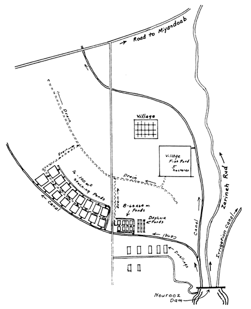
Approximately 3.6 km below the dam site and to the left of the brick dwellings now under construction, the ground slopes gradually into the flats. Here is a desirable site for a warm-water pond station to be supplied with water from the left irrigation canal. Two canals, one on each side of the dam are to be built. A map of the layout of the probable location of the irrigation canals was sought in the office of the Ministry of Water and Power in Tabriz, but Eng. Kafai stated that none had been prepared to date. He was requested to furnish the Ministry of Natural Resources with a layout map of the canals when it does become available. He was also of the opinion that the open lands in the area could be obtained at low cost. He also suggested looking for pond sites in the area between the head of Nourooz Dam and Koresh-Kabir Dam where he reported clay soils. A sketch (Fig. 1) is attached that shows the suggested location of a pond station for use in supplying fish for stocking village or commercial fish ponds in the area.
There are other possible sites for building ponds beyond the village. A fish pond of 5 ha or more might be built near it when the elevations in relation to the irrigation canals are known.
(2) Public Fishing Lake Site - Minah Village
This village is located about 11.7 km from the Tabriz-Ahar highway on the road to Heris.
A small stream with a flow of about 19 l/sec. (300 gpm) on 9 November 1968, flowed by the village which is located on the side and top of the hill on the right bank of the stream.
The proposed dam site would be located at the village where the expanded, fairly level valley above constricts. The hills to the east are low, and the height of the dam will be limited by their height. It is estimated that a dam of about 8 m in height could be built here creating a lake of 250 acres (100 ha or more). A low area exists on the east side that may require fills at two or three points. A sketch (Fig. 2) is attached showing the approximate location of the dam and the fills if they are necessary. These low area fills could be rip-rapped to serve as spillways, particularly the low area closest to the village.
The soil in this area appears satisfactory for the construction of pond banks.
(3) Maghsoodlu Lake Site No. 1
Location 3.4 km east of Minah and 3.3 km west of Maghsoodlu on the Heris road.
(Not to scale)
Fig. 1 - Suggested Layout of Ponds below Nourooz Dam
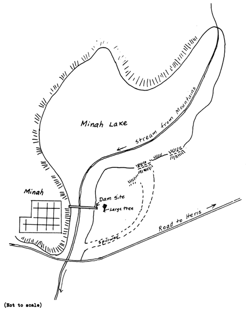
Fig. 2 - Sketch of Minah Lake
A deep ravine with a low gradient extends northward toward the mountains in an ideal place for a low cost public fishing lake about 1.5 – 2.0 km long and about 90 m in width. On 9 November 1968 a small stream of only 30 gpm flowed down this ravine. Its water had a total alkalinity of 270 mg/l and calcium-magnesium hardness of 350 mg/l.
The loam here contains a high percentage of sand, and while some sand in the soil makes a strong fill material, it is possible that the soil at this site may be too sandy. On the other hand, the distance across this ravine at the Heris road is short, so that a good clay core at the base or the use of inter-locking sheet piling driven across the base of the dam may be useful and not too expensive to install to prevent seepage at the base. The road to Heris might be relocated to cross the dam fill which would be approximately 12 m in height. The spillway area would be over a rip-rapped portion of the dam itself, or preferably through a cut over the west hill.
Aside from the questionable soil, the site is ideal for a low cost “sky” pond. It is suggested that if it is feasible to build this dam from an engineering standpoint, then the lake could be stocked at the rate of 1,250 bluegills and 125 large mouth black base per hectare to provide fishing for the nearby villages.
(4) Maghsoodlu Lake Site No. 2
Maghsoodlu is located 7.6 km west of Heris on a hillside and hilltop on the right bank of a small stream with a flow of about 200 gpm.
This appears to be a prime lake site. Location of the dam (Fig. 3) would probably be just above the village where the valley constricts below an expanded valley that appears to be quite level for at least 0.5 km. Northeastward, toward the mountains, an arm of the lake would extend a long distance. From the northwest, a small stream flows through a steeper ravine from the mountains, but before it reaches the expanded part of the valley that would constitute the main part of the lake, the water is diverted and carried high along the west hillside into the village. Some lands in the valley floor above the village are under cultivation.
A dam could be built to almost any height, for the hills rise to more than 40 m above the valley floor. A dam 12–15 m in height is suggested with a spillway over the gently sloping hillside on the left bank. Soils in this area contain much less sand than several kilometres farther west, and appear to be good for fill material.
The valley at the village did not appear to be torn by severe floods despite a large drainage area above the village.
The stream does not dry up in summer. The size of the lake area will depend upon the gradient of the valley floor, size of the drainage area above, and its annual runoff. It appeared that a lake of at least 100 acres in area would be possible here.
(5) Bari Site
The location of this site was recorded from two reference points, but unfortunately not from nearby Bari. The potential lake site is east of the highway at a point 39 km from the Tabriz-Ahar highway, or 12.6 km south of Heris. Its distance south of Bari is estimated to be about 3 km.
Over the hill to the east, in predominantely clay soils, is a large drainage area without a stream of significant flow, where it is believed that a large “sky” pond of 100 ha or more could be built.
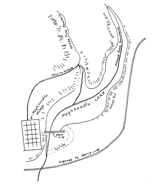
Fig. 3 - Sketch of Maghsoodlu Lake
(Not to scale)
The hillsides on both sides of the valley slope rather gently to the low lands. The gradient in the valley floor also appears to be quite gentle, and the hills rise to such height, that a dam of any height up to about 20 m could be built across this valley.
Severe flooding conditions apparently do not affect this valley as it does the neighbouring valley of the Zarna-chay. The size of the drainage area in relation to the size of the lake should be determined. Generally, this should not exceed 25:1, but in this area of low rainfall, it can no doubt be somewhat higher.
Engineering surveys are needed here to determine where a 15 m high dam would actually back water.
(6) Saray Site - Location: 8.2 km east of Saray and 14.3 km west of the junction of the Heris-Mehraban road with the road through Saray.
A 190–200 m wide flat in clay soil above the low-water bridge extends northward towards the mountains for 2 km or more. The hills are low, and the height of the dam, if built near the highway, would probably not exceed 8 m.
There is no flowing stream at this site, but clay soils exist at and above the dam site which will prevent undue loss of water.
(7) Ziri-Chay Site - Location: East of Ziri Village is a wide, grass covered flat that constricts to a narrow valley at the point where the highway crosses the stream. The hills at this point rise to a height of about 15 m above the stream. It was estimated that the stream had a flow of 2.500 gpm (about 158 l/sec.) at the bridge at Ziri. Total alkalinity of the water was 230 mg/l, calcium-magnesium hardness 200 mg/l, temperature 13.5°C, at 13:55 on 11 November 1968. It was interesting to find that the total flow of this stream originates within 2.3 km of the bridge from springs southeast of it. These springs emerge from gravel along the hillside to the south and possessed temperatures of 16°C, (60.8°F) which is favorable for rearing trout.
The surface soil at the dam site appeared good for construction of a dam, but core drillings will be necessary to determine whether there might not be gravel beneath the layer of good topsoil. The level of origin of the springs should also be determined in relation to the maximum height of water in the proposed lake.
It is estimated that a lake of about 150 acres (60 ha) or more could be built here. Height of the dam needed was estimated to be 10 m. The present highway from Sarab to Nir would be relocated to cross the top of the dam. Floods are apparently not a problem here, and the spillway could be on the dam itself.
A trout rearing station is possible at the head of the lake, should the need arise for one in this area.
(8) Jourabchay Site - Location: 6.3 km east of Nir on the Bostanabad to Ardebil Road.
A rather narrow but low-gradient valley lying in a northwest to southeast direction crosses the highway at Jourabchay. A strong stream of cloudy water with a flow of nearly 1 m3/sec. was flowing at the time of the visit. The water was relatively soft with a total alkalinity of 100 mg/l and calcium-magnesium hardness of 90 mg/l. The temperature was 12.5°C, and much of this could very well be spring water, for there was little evidence of torrential floods, such as apparently occur on the north slopes of Savalan mountain. The cloudy condition of the water was no doubt due to recent rains.
The engineering feasibility of a lake site at Jourabchay should be studied. A lake should not be built here if it means the partial destruction of a good trout stream. Stream temperatures of 12 – 14°C are much more favorable for trout growth than the 6°C found in the Basmenj Chay at Beraq on 10 November 1968 at 15:40.
Height of the hills at Jourabchay was about 20 m and the height of a dam here might be about 12 m.
C. Isfahan Area
(1) Pond Fish Culture Sites
Forest Guard Station No. 5 Site at Yazdabad
On the west side of the highway from Isfahan to Shahr Kord at Yazdabad (7–8 km from Isfahan) on the grounds of Forest Guard Station No. 5, is an open area sloping to the north-west which appears suitable for the construction of a limited number of ponds, each one acre in area. The soil is composed of dark reddish clay and small stones. On the east side of the highway is a large irrigation canal from which water is available throughout the year. The area is bounded by a woven wire fence adjoining the highway. A pipe of about 10 cm diameter with valve (apparently unused at present) is already located in this area in an advantagous place to supply a few fish ponds. It is suggested that four fish rearing ponds 64 × 64 m and about 1.5 – 2.0 m deep be built in this area. Four concrete ponds 8 × 3 × 1 m should be built at the north end of the series of ponds for sorting and holding fish. A shelter shed should also be built. With this modest layout (Fig. 4), a beginning could be made in the rearing of fish to stock warm-water village or commercial ponds in the Isfahan area.
Example of method of operation for the production of bluegill and largemouth black bass: stock 50 adult bluegill (6–9 inches long) in each of Ponds 1 and 2 in the spring. These fish will spawn throughout the summer and by October there will be young fish 4–5 cm long numbering into the hundreds of thousands. These can be graded if not uniform in size in the concrete ponds at the end of the series of ponds by means of hardware cloth baskets (2), 45 × 45 × 25 cm deep made of 2 mesh to the inch (2.5 cm) hardware cloth.
These fingerling bluegills can then be used to stock public fishing lakes or village fish ponds at the rate of 1,250 per ha. Care should be taken not to stock them before October or November in this area, because once placed in a new pond they will grow rapidly and may spawn at 7.5–9.0 cm before largemouth bass can be stocked to control their numbers.
Bluegill and bass are stocked in a 10 to 1 ratio and should be the same size, otherwise the bass will eat the bluegill. The stocking rate per acre with largemouth bass fingerlings is one tenth the number of bluegills stocked or 125 per ha.
Ponds 3 and 4 may be used for the production of large mouth bass. Stock Pond 3 with 20 female and 10 adult large-mouth bass, 10–15 inches in length per acre (per pond). Twenty of these adult fish will produce close to 100,000 fry, 50,000 of which may be seined out or trapped while still in schools for stocking in Pond 4 where they will be allowed to remain for a period of about a month. By the time they will have reached a length of 3.5–5.0 cm in length. They are then ready for stocking at a rate of 125 ha in the ponds already stocked in October or November with 1,250 bluegills per ha.
The concrete ponds can be used in the spring (March, April) for the production of daphnia for introduction into all of the ponds, but particularly in Ponds 3 and 4. Daphnia pulex or Daphnia magna are the species of Daphnia recommended for culture. D. pulex has greater tolerance to high water temperatures.
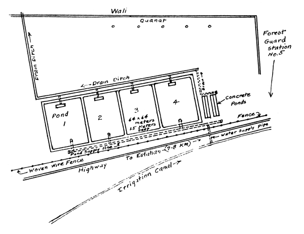
Fig. 4 - Forest Guard Station No 5 Fish Pond Site
(Not to scale)
Ponds 1, 2 and 4 should be fertilized with inorganic fertilizer as soon as filled at the rate of 50 kg of 20-20-5 (N-P-K) fertilizer per ha. If 20-20-5 fertilizer is not available, 8-8-4 or 6-8-4 may be substituted at the rate of 112.5 kg/ha (per pond). Fertilization as soon as the weather becomes warm should be weekly for 3 weeks until the water becomes green or brown with algae or diatoms. Thereafter, one should fertilize the ponds whenever a piece of white plastic on the end of a “dip stick” is visible at 45 cm. 1
Bagh Vahch Pond Station Site
At Bagh Vahch (Fig. 5), 24 km from Isfahan on the main road to Shahr Kord is an irrigation canal at the edge of the high ground. When the new irrigation diversion dam at Nekouabad village is completed, a canal will follow the base of the slopes, well above the present canal. Between the new canal and the road that passes by the village of Ochtarjan is a gentle sloping area in which the soil is a mixture of clay and small stones. This area lies southeast of the main highway and between it and Ochtorjan. It is recommended that a 80-ha area immediately adjacent to the main highway be set aside for the construction of ponds. This land is undeveloped Government owned land.
There is also ample room in the area west of Ochtarjan and adjacent to it, for the construction of a 2–4 ha public fishing pond, or commercial fish ponds.
On 23 November 1968 at Pol Kalleh, the Zayandeh Rud River water had a temperature of 7.9°C at 11:50. The calcium-magnesium hardness of the river water was 180 mg/l and the total alkalinity 160 mg/l. Water taken into the canal at Nekoubad village will have these chemical characteristics.
Gayart Pond Station Site
About 12.5 km east from the city limits of Isfahan on the highway to Nain, immediately east of Karun Katchali mountain, is an area in reddish clay and small stones that slopes gently to the east, which is suitable for fish ponds. A canal originating at the Barrage Abshar below Isfahan will flow eastward from the left bank of the Zayandeh Rud eastward to Gayart, then south along the east slopes of Karoun Katchali and Kouh Divsalam past the villages of Doulab and Dideran to the river. There is a vast undeveloped area on these slopes. The exact location of the canal planned was not known to us, but a very large layout of ponds is possible in this area, depending upon the water supply. The latter may be contaminated with dyes or other industrial wastes at times judging from the appearance of the water on a visit to the Barrage Abshar area on 27 November 1968. Water quality conditions should be investigated before any ponds are built.
(2) Village Pond Sites
The search for pond sites, at first, was greatly curtailed because of the lack of road maps. The expert was solely dependent upon an aeronautical map, but later through the Ministry of Water and Power, obtained a copy of the new irrigation scheme for the area. It is believed that this area has great possibilities for fish ponds.
Upstream on the Zayandeh Rud about 113 km west of Isfahan, the Shah Abbas Dam is about 65 percent completed. This 100 m high dam will provide storage for about 900,000,000 m3 of water per year. It will have a surface area of 5 km2. Releases of water from it will be used for the production of hydroelectric power. About 5 km below it is a low dam about 11 m in height, built it is presumed, to reduce turbulence below the high dam and to even the flow of water. Minimum flow will be 8 m3/sec.
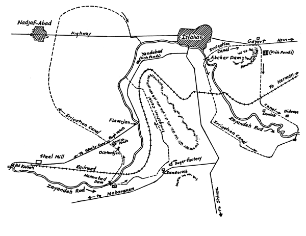
Fig. 5 - Proposed New Canals in the Isfahan Area with Location of Fish Pond Sites
(Not to scale)
The lake formed by the dam will be trout water. Rainbow trout have already been successfully introduced into the Zayandeh Rud in this area. A sample of water collected at the site of the low dam had a temperature of 8.5°C at 12:50 on 26 November 1968. The calcium-magnesium hardness was 180 mg/l and the total alkalinity 160 mg/l.
About 40 km by river above Isfahan, a diversion dam will soon be built at Nekoubad for irrigating a large area south and east of the city. It will have two main canals leading away from it, one down the left bank that diverges off in the direction of Najafabad, and the other down the right bank first in an easterly direction past the beet sugar factory, then to the north along the base of the mountains to the east of the river. The sketch (Fig. 5) shows the probable routes of the canals. The gentle slopes along the proposed canals should provide village pond sites in the Dehsorkh, Aminabad, Siah Afcha, and Bagh Koumeh areas. The soils in this area contain reddish clays mixed with small stones.
The area to the southeast of Koum Katchali mountain slopes gently away from the high ground and the character of the soil is such that ponds can be built anywhere there that water is available.
These are just a few of the areas adjacent to the proposed new canals where it will be possible to build ponds. As soon as the exact location of the canals are known, the area should be searched for additional sites.
(3) Other Possibilities for Ponds in the Isfahan Area
A concrete canal parallels the highway west of Najafabad for 39 km. There are uncultivated areas along this canal where a few public fishing ponds can be built. One such area occurs at a village near the beginning of the concrete section of the canal which originates at Damen mountain.
Near Golab village, the road to Shah Abbas dam crosses a canal which had a flow of about 125 l/sec. (2,000 gmp) a temperature of 13.5°C, total alkalinity of 170 mg/l and calcium-magnesium hardness of 180 mg/l. This stream is believed to originate from a ghanat. It was cold enough to support trout, but what temperatures prevail in mid-summer are unknown.
Another such stream parallels the paved road for a short distance 17.1 km from Shahr Kord on the road to Isfahan. It had a flow of about 1,200 gpm (76 l/sec), temperature of 16.7°C (62°F) at 12:50 and contained some small fishes. A stone lifted from the stream revealed the presence of many small mayflies (Baetidae). The total alkalinity of this water was 140 mg/l, and calcium-magnesium hardness 160 mg/l. Such a stream could undoubtedly support trout, depending upon the maximum temperatures.
In Iran, as seen from the air, streams emerge from ghanats and flow in the open for several kilometres to villages or to cultivated fields. Aerial surveys might be conducted for the location of these for later observation as to oxygen and temperature conditions. They are not subject to floods, but would require racks or self-cleaning screens to prevent stocked fish from ending up in cultivated fields.
D. Shiraz Area
(1) Dashg-Arjan Spring
Trout Rearing Station Site: This spring, at Dashg-Arjan, 70 km west from Shiraz on the Kazerun road has a total flow of about 1,500 gpm (95 l/sec.) that probably can be improved with a collection system. It has the necessary water supply for a modest trout rearing facility. The lay of the land is such that rearing ponds could be built below the highway at this point.
Where the spring water emerges from a limestone cavern, the water is used for filling water bags and by the village people of Dashg-Arjan. The spring creek flows into the great natural bowl that has a freshwater lake in it following periods of heavy rainfall. At the time of our visit, the lake was nearly dry. It was a gathering place for cranes, egrets, geese and other aquatic birds.
The water quality characteristics of the spring water at the cavern were as follows: Temperature 13.2°C (55.7°F) at 12:10, pH 7.7, free CO2 - 24 mg/l; chlorides 5.0 mg/l; calcium-magnesium hardness 290 mg/l; total alkalinity 180 mg/l; turbidity 0.0, on 15 December 1968.
(2) Chehelcheshmeh Springs: Location: Chehelcheshmeh. About 50 km west of Shiraz off the Kazerun road.
Trout Rearing Station Site.
There are two large springs at Chehelcheshmeh village and several smaller springs. Both are bubbling springs (supercharged with gases) and probably originate from the same underground source. It is estimated that the smaller spring had a flow of 400 gpm (25 l/sec.) and the larger spring 1,000 gpm (63 l/sec.). The water temperature of these springs was 12°C at 13:30 on 15 December 1968; the air temperature 15°C; pH 7.6, free CO2 - 20.0 mg/l; chloride 7.5 mg/l; calcium-magnesium hardness 350 mg/l and total alkalinity 220 mg/l. The stream immediately below the larger spring contained moss which harboured large numbers of freshwater shrimp, excellent food for fish.
Below both springs, the lay of the land and its gradient is such that concrete trout-rearing ponds could readily be built. The soil contains extensive deposits of gravel.
A rather steep gradient sloping towards the Quareh-Aghaj River is beneficial because mechanical aeration of the spring water would be required to remove excess gases in the spring water which will cause gas popeye in fry and fingerling trout if unaerated. The spring water is otherwise well suited for trout culture.
Other advantages of the site are that it is close to a good highway, and apparently, close to streams which have been suggested for trout stocking. Its proximity to the village of Chehelsheshmeh is another advantage.
The combined supply of water is sufficient for 3 double series of raceways with four ponds in each series supplied with at least 200 gpm of spring water (after aeration). Suggested dimensions of the individual ponds are 31 × 3 × 1.25 m with a capacity of 2,000 cubic feet (62.3 m3).
(3) Dariush-Kabir Dam Site
Fish cultural station Dariush-Kabir Irrigation Dam is under construction on the Kur River about 57 km above the Shiraz-Persepolis highway. When the 60 m high dam is completed, the reservoir formed will have a storage capacity of 990,000,000 m3, length of about 24 km and average width of about 9.5 km.
The main canal (Fig. 6) that leads into the vast plains below the dam is being built to transport a maximum of 44 m3/sec. of water for irrigation. A contract to build 32 km of canals was in effect. When this contract is completed, about 20 km of the main canal from the dam to the division point and a branch canal northeastward 12 km to cross beneath the Kur River bed will have been built. Water flowing in this canal in the direction of Persepolis will be siphoned under the existing river channel.
Two areas where a fish cultural station could be built were located below the Dariush-Kabir Dam. The first of these occurred about 5 km below the dam in the high plains at this point. Here the canal parallels the road and the water level will be somewhat above the plain. A second, and perhaps better area, exists a short distance above the Division Point, where a concrete structure for controlling flows into two lateral canals was under construction. The soil in both area is very good for fish ponds. At the division point, the ground water level is down about 2 m below the surface of the ground.
The Kur River swings into the line of the main canal about 6 km above the division point. Here the winding river lies deep in the plain about 10 m below the general plain level. It is presumed that the Kur River will be diverted away from this area, perhaps leaving an area where some public fishing ponds could be built. It is suggested that the Ministry of Natural Resources observe this area closely to determine what possibilities exist for earthen dams in the old river bed that would create ponds of 2 ha or more.
It would be advisable for the Ministry to reserve an area of 100 ha above the division point for the construction of a fish cultural station.
Kur River water had the following water quality characteristics:
A. Above the Fertilizer Factory: 16 December 1968, 16:00 hrs
B. Below old bridge on highway to Persepolis: 19 December 1968, 13:30 hrs
Milligram per litre
| Turbidity JTU | pH | Free CO2 | Calcium-magnesium hardness | Total alkalinity | Chlorides |
| A. 35 | 8.58 | 6.0 | 210 | 220 | 110 |
| B. 17 | 8.63 | 4.0 | 200 | 220 | 110 |
(4) Other Springs in the Shiraz Area
Enroute to Darab from Shiraz and in the neighbourhood of Darab, a few large springs were visited.
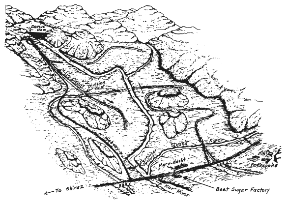
Fig. 6 - Dorudzan Irrigation Project Darius-Kabir Dam
(Not to scale)
Although it appeared that none of them could be used for fish cultural purposes, their recorded water quality characteristics are reported here:
Tazang Spring: Location: on rock-strewn mountain side 15 km east of Sarvestan.
This stream of relatively hard water emerges in a unique setting high on the mountain side with camels, sheep and goats grazing in its vicinity. The estimated flow rate was 1,200 gpm (76 l/sec.), temperature 22°C (71.6°F), pH 7.4, free CO2 22 mg/l; turbidity 0.0; chloride 127.5; total alkalinity 170 mg/l and calcium-magnesium hardness 360 mg/l.
This thermal spring flows by a circuitous route to Sarvestan where it used as the town's water supply and for irrigation of crops.
It is too warm for trout culture, and the supply is not great enough for both agricultural use and a supply for a village fish pond.
Ateshkadeh Spring at Tang-Roniz, northwest of Fasa
This large spring emerges at the base of a mountain in a gap where the downhill approach from the west gives the impression of outgoing drainage instead of incoming, as it actually is.
The warm, 18.5°C (65.3°F) springs arise in a large deep blue hole about one-fourth acre in area containing many fish. The volume of flow was sight estimated to be about 1,500 – 1,800 gpm (95–114 l/sec.). It flows eastward in the direction of Fasa, and its flow is used for the irrigation of extensive cotton fields in the area. It is too warm for trout culture, but it could be used to supply warm-water ponds built at points in the cultivated land area below the spring. Drains would lead to the stream that drains from the gap down to a point where flood waters have washed in large quantities of gravel. Probably all of this water is used at some time for irrigation. Analysis of the water as it left the spring showed a pH of 7.3; free CO2 of 20 mg/l; calcium-magnesium hardness of 410 mg/l; total alkalinity of 160 mg/l, and chloride content of 110 mg/l, on 17 December 1968.
Aghlanghez Spring above Korsia near the Ministry of Natural Resources Forage Station Bakhfarge (Darab).
A total of about 7,000 gpm (443 l/sec.), or more, of relatively hard water emerges from limestone formations in two deep spring holes, located along the base of a mountain, the uppermost of which was reported to be 6 m deep and the lower 9 m deep. The water was quite warm, with a temperature of 21.0°C (69.8°F). Immediately below the spring is privately owned cultivated land in an area where cotton appears to be the principal crop. Cattails (Typha) encircle the spring and the stream margins as it flows in a westward direction toward Korsia above which it splits into two streams to cross the highway (Darab-Fasa) at two points. The west branch flows on into the salt flats and salty soils in that direction while the east branch is used for irrigating cotton fields. Water analyses of the spring water showed a turbidity of 0.0; pH 7.5; calcium-magnesium hardness of 210 mg/l; total alkalinity of 180 mg/l; free CO2 of 20 mg/l; chloride content of 17.5 mg/l.
The land area west of Korsia is apparently too salty for agricultural use. Whether useful ponds could be built here is questionable, but perhaps it is worth a try for the spring water itself has relatively low chloride content, and the lay of the land below the highway is such that water can be led by gravity into one experimental pond, or a group of ponds. Some species of fish such as the souf, largemouth bass and the bluegill are quite tolerant of salt up to 10 percent of sea water strength (3,500 mg/l). Neuhaus (1934) observed that although the souf is originally a typical freshwater fish, the species can endure slightly brackish water up to about 6,000 mg/l for prolonged periods.1
It is suggested that a one-hectare village fish pond could be built below the highway at Korsia, leached (if necessary) for one month with a strong flow of fresh water from the spring. The inflowing water would then be reduced to that necessary to replace water lost by evaporation and seepage, before stocking with bluegill and largemouth bass at the rate of 1,250 bluegills and 125 bass per hectare. The latter species could be reared at the Ministry's Forage Station nearby where four ponds of 0.5 acre each could be built and supplied with well water.
Naghsh-Shahpur Spring - Location: About 7.7 km from Darab.
This large spring originates at the base of a mountain from a limestone formation. A figure of King Shahpur and attendants has been carved in the vertical face of the limestone mountain over the spring. It has a large flow of at least 5,000 gpm (316 l/sec.), but lies several feet below the surface of the large plains of good soil adjacent to it. To get water to these plains would require the pumping of water. The lands here are used for the growing of cotton.
Some water quality characteristics of the spring water were, on 18 December 1968, as follows: turbidity 6.0 JTU; pH 8.3; free CO2 24 mg/l; calcium-magnesium hardness 210; total alkalinity 190 mg/l; temperature 23°C (73.4°F).
(5) Forage Station Bakhfarge - Ministry of Natural Resources, near Darab.
In a visit to the station, it appeared that about four 0.5 acre ponds could be built in the area back of the station building and to the east of it. These ponds would be useful for rearing ponds for the stocking of species of fish suitable for planting in village fish ponds in the general area, or for the holding of brood stock in a place where they can be protected from poaching.
Water supply could be furnished from a well back of the station building where the Ministry has a large pump that is operated almost continuously during the spring and summer periods. The pump which delivers about 600 gpm (38 l/sec.) was idle at the time of our visit, 18 December 1968, but was started up for samples of water for chemical analyses. The analyses showed that the water has a good oxygen content (7.0 mg/l) as it emerges from the ground; pH 8.2; free CO2 12.0 mg/l; calcium-magnesium hardness 155 mg/l, total alkalinity 155 mg/l; chlorides 10.0 mg/l; and temperature of 19°C. For well water, this is very good quality.
Before building any ponds here, however, the general needs of the area for warm-water fishes should, of course, be considered.
![]()
![]()
![]()