


Geography, Climate and Social Development
Zimbabwe is a land-locked country of 39 million hectares. Zimbabwe’s natural vegetation cover is characterised by savannah woodlands interspersed with open grassed drainage lines or dambos. Impeded drainage gives rise to limited areas of open grassland. A few patches of sub-tropical forests occur in the eastern districts.
Zimbabwe has few perennial rivers and no natural lakes. Storage development is therefore dependent on run-off water accumulated during the rainy season. There are over 8,000 dams in the country with a storage capacity of about 4,900 million cubic metres. Rainfall is the major climatic factor influencing the performance of renewable natural resource sectors such as agriculture, forestry and wildlife in Zimbabwe.
Zimbabwe’s population from the 1992 Census was 10.4 million and is now estimated at almost 12 million. A declining infant mortality rate has been largely credited for the rapid increase in the country’s population over the years although the effect of the AIDS pandemic on population growth still remains to be seen. Almost 50 percent of the total population are under 15 years of age, which poses long-term challenges to biodiversity conservation. In rural areas, characterised by low investment, poverty and lack of economic alternatives, people tend to rely on natural resources for subsistence and income generation.
Land Tenure, Property Rights and Land Use Systems
Four land tenure systems are generally recognised in Zimbabwe. These are the freehold (private), state land, communal and leasehold (resettlement) tenure systems. The land tenure system in the country is extremely complex, however in a strict legal sense, there are only two tenure categories; freehold and state land. Communal and resettlement tenure systems are a subset of the state land category. The freehold tenure system is prevalent in the commercial farming sector which, consists of large scale and small-scale commercial farmers, and covers about 32 percent of the country. The communal land tenure system is applicable to 42 percent of Zimbabwe’s land area where the majority of the country’s population resides. Factors such as high population growth, a limited land base of low productivity, and a shift from subsistence to an income-based economy have contributed to a general failure of communal tenure and subsequent environmental degradation.
Macroeconomic Structure And Policies
Zimbabwe is a developing country with a per capita income of $718 USD2, based on total GDP (in nominal terms) of $85.5 billion ZD3, total population of approximately 11.9 million, and an average exchange rate of $10.00 ZD per USD in 1996 (CSO 1997). However, in real terms, the GDP per capita has declined from $271 USD in 1980 to $201 USD in 1996 largely due to high inflation and the depreciation of the Zimbabwe dollar. In local currency, real GDP per capita is largely unchanged from 1985.
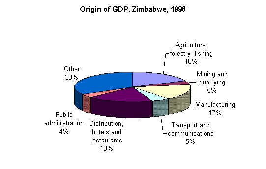
The Zimbabwe economy is heavily dependent upon the natural resource base for generating employment, income and foreign exchange. In particular, the economy is dominated by manufacturing, agriculture/forestry/fishing, tourism and mining (Figure 1). Forestry GDP mainly reflects logging of commercial pine plantations in the eastern part of the country. The consensus is that primary commercial forest production might contribute at most 2 to 3 percent of total GDP with primary agriculture accounting for 11 to 12 percent. Fishing accounts for the remainder. Tourism is captured by the GDP category of Distribution, hotels and restaurants. The category "other" includes finance and insurance, electricity and water, construction, real estate, education and health, and domestic services.
Figure 1 - Share of GDP by sector, Zimbabwe, 1996
Zimbabwe’s economy has undergone dramatic changes during the last six years due to the implementation of two successive economic reform programmes. The major policy objectives of these economic reform programmes are:
• trade and investment liberalisationWhile the first four objectives have been largely met, the last three have been more problematic due to several constraints. These include severe droughts earlier this decade, government assumption of large parastatal debts, and increased social expenditures on issues such as the AIDS pandemic and war veterans. Declining economic situations for many rural and urban poor will only serve to increase the demands on the natural resource base.
Forest Resources and Forestry in Zimbabwe
a) Land Use and Forest Cover Types
Sixty six percent of the country’s land area is under various woodland types compared to 27 percent under cultivation (Table 1). The heaviest concentrations of indigenous woodlands occur in the gazetted state forests, national parks, the Eastern Highlands and large-scale commercial farms. Forest and woodlands are classified into five cover types according to the Forestry Commission (Table 2). The total area of forest types in Table 2 does not exactly correspond to the total of natural forests, plantations and indigenous woodlands in Table 1 due to differences in terminology and measurement. Table 2 represents more recent information.
Table 1 - Land classification in Zimbabwe.
|
Land Use |
Area (000ha) |
% of total |
|
Natural forestsa |
11.60 |
0.03 |
|
Plantations |
155.60 |
0.40 |
|
Indigenous woodlands |
25,771.40 |
65.92 |
|
Grasslands |
1,893.90 |
4.85 |
|
Cultivated land |
10,738.10 |
24.47 |
|
Settlementsb |
139.10 |
0.36 |
|
Otherc |
379.40 |
0.97 |
|
Total |
39,089.40 |
100.00 |
Table 2 - Forest resource classification by crown closure and height
|
Cover class |
Canopy closure (%) |
Height (metres) |
Area (000ha.) |
% of forest area |
|
Natural forests |
80-100 |
15+ |
11.60 |
0.03 |
|
Exotic plantations |
80-100 |
<1-15+ |
155.90 |
0.40 |
|
Woodlands |
20-80 |
5-15 |
20,797.40 |
53.20 |
|
Bushlands |
20-80 |
1-5 |
974.10 |
12.72 |
|
Wooded grassland |
<20 |
1-15+ |
1,204.80 |
3.08 |
|
Total |
27,143.80 |
69.43 |
b) Exotic plantations
Zimbabwe has a well-established plantation forest resource base covering some 155,853 ha. About 90 percent of the plantations are located in the eastern districts. This area is characterised by high altitudes (700 to 2,200 metres above sea level) and high rainfall (average of 1,000 mm/annum). About 71 percent of the planted area is under softwoods (pines), 13 percent under hardwoods (eucalyptus) and 16 percent under wattle. With respect to the plantation ownership pattern, about 42 percent belong to the State, 54 percent to private companies and the remainder to small private growers who include co-operatives.
c) Indigenous forests
The area of indigenous forest is comprised of natural forests, woodlands, bushlands and wooded grasslands cover types from Table 2. Unfortunately, the Forestry Commission’s inventory work has not progressed to the stage where the areas of these forests can be matched to the cover types in Table 2.
d) Causes of forest decline
About 70 percent of the country’s total population live in communal areas and depend directly on forests for firewood, construction timber, food and fodder. The open access, common property situation in these forests lends itself to over-exploitation. The gradual erosion of cultural and ethical values tied to forests has also contributed to woodland degradation. Fires, insects, disease and browsing by wildlife are also significant factors. By far however, the opening up of forestland for agricultural expansion tied to resettlement, is the major reason for the loss of forest biodiversity. Although no accurate figures on deforestation exist due to inadequate forestry change data, it is estimated that about 70,000 ha. of Zimbabwe’s natural forests are lost each year (FAO, 1997) due mainly to agricultural expansion.
e) Economic values and wood supply in non-commercial forestry
Although a significant proportion of the country (69 percent) contains indigenous forests in the various cover type categories (Table 2), there is still no corresponding information on timber volumes by species and age class. Furthermore, the available inventory data do not classify these forests by dominant species which could help identify the various timber and non-timber products and services flowing from them.
Zimbabwe’s natural forests generate a wide range of timber and non-timber products and services. The products include fuelwood for charcoal making, sawn timber and pulpwood, building materials, wood for small artisanal crafts, fodder, fruits, honey, mushroom, insects, bark for rope, medicine, leaf litter and gum. The services include watershed conservation carbon fixation; and the provision of windbreaks, shade, soil stability and wildlife habitat. No accurate economic value has been established for these goods and services but specific studies can provide some point estimates. For example, a modified contingent valuation study (CVM) estimated the mean direct and indirect values of a range of timber and non-timber products in miombo woodlands. An average value was ZD $200/ha per year (Campbell, et al. 1991). Based on this figure (and mindful of many caveats about extrapolating the very specific Campbell et al. results), the total stock value of indigenous woodlands (21 million ha from Table 2) can be crudely estimated at ZD $4.2 billion. This figure is an order of magnitude estimate only, based on a specific study in one small area of the country. More accurate estimates of woodland values require extensive CVM research across a wider range of geographic areas and forest types.
f) Forest stocking densities
Millington and Townsend (1989) suggest the following stocking densities for the three woody biomass classes that compare well with the Forestry Commission (1997) woody cover classes:
| • Wooded grassland |
11.42t/ha |
| • Bushland |
23.36t/ha |
| • Woodland |
49.89t/ha |
These stocking levels are conservative when compared to Chidumayo (1995)'s levels of 53t/ha in western dry miombo and 72t/ha in eastern dry miombo of Zambia. However, the figures are within the general ranges of 21.16 tonnes of wood biomass per ha to 39.73 tonnes per ha for the miombo plots in Sengwa and Marondera respectively (Frost 1996). The average growing stock across all provinces was 30.2 t/ha-1 (ranging from 6.129 in Bulawayo to 37.3 in Matabeleland North).
