![]()
![]()
![]()
SCSP-SFDC/77/AEn/CP3
by
G.B. Thompson and Y.C. Tai
Fisheries Research Division
Agriculture and Fisheries Department
Hong Kong
1. Hong Kong, with its urban areas centred around Victoria Harbour and encircled by mountains, suffers from a chronic shortage of flat land. Because of this it is necessary to create land on which to build houses, factories and the infrastructure of a commercial and industrial community, by reclaiming shallow parts of the sea. This process has been evolving over the past 100 years, but the enormous increases in population and economic activity over the past 25 years have resulted in a dramatic upsurge in the scale of reclamations and associated activities. At present there are in hand and proposed some 50 reclamations. Of course, many of these are located in Victoria Harbour or in typhoon shelters, and only affect fisheries through their influences on the typhoon anchorages available for the fishing fleet. However, there are 11 current and proposed projects directly affecting fisheries. Moreover, all reclamations involve the disposal of quantities of marine sludge and other spoil, which is dumped in specially gazetted dumping areas within the restricted territorial waters.
2. The long, indented coastline of Hong Kong contains many bays and inlets which are natural areas of aggregation for over 100 fish species, mainly in the summer and autumn and especially in the eastern waters which are exposed to the influence of oceanic currents. The inshore waters represent a significant propagation, nursery and feeding ground for various commercially important food fishes, in addition to supporting a thriving marine cage culture fishery, and these environments are increasingly threatened by the escalating scale of development and reclamation.
3. Three major problems are involved here. First, there is the permanent loss of portions of the shallow inshore sea and intertidal areas, which are often rich in fauna and are thought to be major nursery grounds for commercially exploited fish species. This may have adverse effects on both offshore and inshore capture fisheries and also on marine fish cage culture, which depends on wild fry. Particular problems may be expected in:
Tolo Harbour, where an almost completely enclosed natural harbour was once bordered by gently sloping mud and shingle shores culminating in mangrove communities in the upper shore. Current developments are changing this into a much smaller harbour bordered largely by artificial shores and sea walls. No work has been done on the biological consequences of these changes, or their significance for the fishing industry, although some related research on plankton and benthos is in hand for other purposes.
Port Shelter, another shallow enclosed area suitable for mariculture, where some reclamation is expected but on a smaller scale.
Junk Bay, a bay already much affected by pollution from Victoria Harbour, and which has been proposed as a site for new industrial developments on reclaimed land.
Northeast Lantau, a largely unspoiled coast which is now expected to become a major site for industrial development and possibly a new airport, mostly on reclaimed land.
Deep Bay, where a delicate but productive mangrove ecosystem is threatened by various development, and further down the shore are oyster beds that are suffering from declining yields and growth rates.
4. Second, there is the polluting effect of the process of reclamation on the adjacent sea area. Very little is known about this, but a project on “The ecology of reclamation” has been completed by Hong Kong University.
5. Third, there is the destruction of the sea bed through activities associated with land development projects, such as marine sand dredging and spoil dumping, and the polluting effect of these activities. The effects of sand dredging have not been studied in Hong Kong, although such activities may damage fish spawning grounds or mollusc settlement areas, and accurate and up-to-date information on the distribution of spawning and nursery grounds for the main commercially valuable species of fish, and on the distribution of all exploitable stocks of sedentary shellfish is not available. An article expanding on this problem is attached (ANNEX A). There are 13 spoil dumping grounds in use in HongKong coastal waters and more are urgently required, but no investigations of their effects on fisheries have been completed: a pilot study is currently in hand.
ANNEX A
EDITORIAL*
SAND AND GRAVEL EXTRACTION
Sand and gravel extraction from the marine environment is an important growing industry, especially in the southern North Sea, the Channel and at other points around the coasts of England and Wales. The pollution implications are essentially local but may be severe on this scale because bottom conditions may be drastically altered over sizeable areas. If these include sites of critical importance in biological terms, such as fish-spawning grounds or mollusc settlement areas, then substantial damage may be done.
The implications for fisheries generally were admirably reviewed by a Working Group of the International Council for the Exploration of the Sea (ICES Cooperative Research Report No. 46, 1975). This report identified particularly the hazard to herring spawning grounds and to areas of sea bottom inhabited by sand-eels on which, in the North Sea, a large industrial fishery is based. It was concluded that concessions to extract aggregate must avoid such areas and more precise mapping of their position was recommended. If this were done serious damage to fisheries could be avoided.
* Marine Pollution Bulletin, Volume 8/Number 9/September 1977: 193
A second report on this subject from ICES (Cooperative Research Report No. 64, April 1977) gives some details of research projects on the effects of dredging for sand and gravel being carried out in the United Kingdom (Southwold-Thorpeness) and France (Baie de Seine). In the French project a deep trench has been excavated in a selected test area which is expected to become the centre of a large dredging industry. The soil is sand overlying gravel and approximately 1.2 × 10⁶ m3 of material have been removed from a dredged channel 70–150 m wide and 4–6 m deep extending over 1700 m. The principal studies so far have been of recolonization of the disturbed bottom and the dispersion and deposition of fine material washed out of the dredge. Nor surprisingly the gravel bed exposed below the removed sand (dominated by the polychaete worm Ophelia borealis) has been recolonized by quite different animals, dominated at first by hydroids and polyzoa, but then by a mixed assemblage of attached sessile animals and mobile epibenthos. In so far as the results were as might have been expected, this part of the study is of little interest. The transport and deposition of disturbed fine material was studied by radioactive labelling of sediments. In general the results confirm those of previous theoretical and field studies. Increased turbidity was measured throughout an area of 50–70 km2 around the dredger but particles larger than 40 micra were found to settle out within 1.5 km of the test site. In other words, major smothering effects on the bottom were quite local - within a radius of 1.6 km from the site. Fine silt and clay, however, remained in suspension over greater distances and “it was observed that 10% of the fines may still be held in suspension 6–12 cm from the point of origin.” Quite significantly, in contrast, in respect of the English study off the Suffolk coast it was concluded that the effects of outwashed fine material from the dredger could be disregarded because of the high natural turbidity levels of the dredging ground. This will be the general situation in the southern North Sea and in many other coastal areas where sand and gravel extraction is being pursued.
This Second Report of the ICES Working Group also gives consideration to the protection of fish nursery grounds. It is noted that in several European countries the principle of excluding dredging from the near-shore zone has been accepted for the purpose of protecting the coast and this has served also to protect shallow water nursery areas for young fish. Legislation has been enacted in the Netherlands and Belgium while in the Federal Republic of Germany a prohibited area has been established covering the whole North Sea coast. In the United Kingdom dredging is not normally allowed within 5 km on grounds of coast protection, although recent studies in the Firths of Forth and Clyde, in Scotland, claim to have shown that substantial dredging of sand would be possible without affecting the adjacent coast: thus locally-important flatfish nursery grounds in this area may be at risk unless the selection of actual exploitation areas is controlled by fishery interests. The ICES Report recommends that “the practice already adopted by some countries of prohibiting sand and gravel dredging in the coastal zone and in fish nursery areas be brought to the notice of the appropriate authorities in other member countries with a view to making it generally recognized practice.” This is rather sloppily worded and imprecise (does it include estuaries, for example, in which dredging takes place for several purposes?) and moreover fails to recognize the interest in Norway in extracting gravel from certain fjords (recorded in the ICES Report), the situation in major Scottish estuaries mentioned above, conditions in the USA where dredging of aggregate from estuaries, lagoons, etc. is commonplace and, indeed, the general worldwide problem of maintaining navigable channels in coastal waters. Moreover, the important question of extracting aggregate from nearshore banks for in-filling in coastal development projects such as airports seems to have been overlooked. The extent of coastal dredging in the United States of America and some other countries is enormous.
The ICES Report can also be criticized for failing to point out sufficiently clearly to fishery scientists that if extraction of marine aggregate is to be located so as to avoid damage to fisheries, accurate up-to-date information on the distribution of spawning and nursery grounds for the main commercially valuable species of fish and on the distribution of all exploitable stocks of sedentary shellfish, must be readily available at all times. It should not be necessary to make a new survey every time an application for a prospecting or exploitation licence is received. As has been said before, on many occasions, this information is needed as a basis for any rational policy of sea disposal of waste. If we do not know what is where, how can we protect it?
H.A. COLE
SCSP-SFDC/77/AEn/CP6
by
J.C. Guanzon
UNDP/PHI Pampanga Delta/Candaba Swamp Area Development Project1
Department of Public Works, Transportation and Communication
and
S.S. Basa
Bureau of Fisheries and Aquatic Resources
Manila, Philippines
1. INTRODUCTION
The fishpond industry in Central Luzon especially within the Pampanga River Delta Area is the economic backbone of the area and it provides means of livelihood to a greater segment of the area's population. Beset by severe and complicated operational problems, the industry is presently supported by a very precarious and degenerating economic footing and it provides a very narrow and tenuous economic base for the area. Economic performance of the industry is greatly hampered by adverse climatic behaviour and physiographic changes such as flood, sedimentation, salinity fluctuation, and pollution; by relevant unfavourable economic performances such as lack of supply and surging costs of fertilizers and feeds, seedlings, and fluctuations in market prices; and, by institutionalized practices such as traditional technology and farm management.
2. CLIMATIC SETTING IN THE PHILIPPINES
2.1 Season
There are four types of climatic setting in the country.
The first type has two pronounced seasons; dry from November to April, wet during the rest of the year;
The second type has no dry season with a very pronounced maximum rainfall from November to January;
The third type has seasons not very pronounced; relatively dry from November to April and wet during the rest of the year;
The fourth type has rainfall more or less evenly distributed throughout the year.
The climate of the project area is classified as the first type. In general terms, the climate in the Pampanga River Basin is of pre-humid type, of the tropical belt, with two distinct monsoon periods causing a distinct wet and dry period of rainfall over the area. From June to August, the southwest monsoon, combined with the South Pacific trade winds, bring heavy precipitation augmented by an irregular pattern of typhoons that may extend the rainy period to the end of October. The northeast monsoon and winds cause heavy rainfall on the eastern watershed and coast of Luzon Island and only a negligible amount of rain on the western parts and the Central Luzon Plains. Thus the dry period extends from December to April while November and May are transition months.
2.2 Annual rainfall
The average precipitation is in the order of 2 300 mm ± 10 percent along the Pampanga Delta shore and 1 800 to 2 200 mm in the Pampanga River and Guagua River Basin. It could be seen that about 75 percent of the annual precipitation is concentrated within the June to October period while during the dry months of December to April only about 10 percent of the annual precipitation occurs. The remaining 15 percent occurs between the two transition months, May and November.
2.3 Periodic typhoons
Heavy torrential rain almost always cause widespread severe floods over the country. In Central Luzon, the most destructive tropical cyclones that struck the region during the years from 1972 to 1976 were typhoons named Gloring, Isang, Narsing, Norming, Bidang and Didang. Floods that remained unabated from 2 to 15 days resulted in considerable destruction to life and property. Thousands of hectares of milkfish ponds were inundated enabling the fish stock to escape. In severe cases, additional effects are destruction of dikes, watergates and other structures.
Generally, fishpond drainage are very poor in the area, and dikes and structures are not designed and constructed to withstand adverse weather conditions. Mere rehabilitation and re-input of operational expenses, without even the thought of structural improvements are straining heavily fishpond operator's financial resources.
The natural drainage condition in the Delta area is correlated with the distribution of rainfall, land form, relief, surface soil and substratum condition, land use, etc.
The Delta area consists mainly of the delta plain, the low alluvial terraces and the low-lying area of the Candaba Swamp. All these lands suffer from lack of adequate drainage ways subjecting the major parts of the area to serve as flooding hazard during the rainy season.
Likewise, illegal construction of fishpond dikes along the different tributaries of Pampanga River have constricted the main waterways. These contributed to flooding of nearby areas considerably. Some illegal dike construction which have existed for some time are now being demolished under Presidential Decree 259. Expansion of areas for pond operation from both sides of the river banks makes the waterways narrower.
About 25 percent of the entire deltaic area are under permanent flooding condition and 12 percent are subjected to prolonged and deep flooding during the rainy season. In addition, 24 percent of the area including deep fine textured soils located on the low alluvial plain have very poor to poor natural drainage. The lower lying areas are also subjected to prolonged flooding that restrict their use only after high water recedes.
2.4 Mountains, forests and river systems
The Pampanga area is surrounded by the Sierra Madre Mountains and the Caraballo mountains. The delta area is formed by riverine depositions from the Pampanga River and several smaller streams consisting of small estuaries, brackishwater marshes and wet lands, freshwater swamps and relatively high and dry flat lands criss-crossed with water courses and channels. These maze of water courses drain into the Manila Bay and most of the delta form a single water area during floods.
The lower Pampanga River (downstream of the Sulipan bridge to the Manila Bay) is a typical channel with poor drainage capacity. Throughout this reach, it meanders to different shallow river beds. Although part of its floodwaters flow through the Bebe-San Esteban diversion channel to the Pasag River or the Guagua River, its insufficient carrying capacity causes flooding of the surrounding areas. Similar condition exists in the Pasag, Guagua, Hagonoy and Labangan rivers and other network of small streams in the area.
2.5 Extent and location
The area consists a total land area of 179 000 hectares covering 27 municipalities in the province of Bulacan, Pampanga and Bataan in Central Luzon at the northern tip of Manila. It is part of the Central Luzon plain bounded by the Sierra Madre on the east and the Zambales mountain ridge on the west. This inter-mountain area is almost completely flat of elevation, just slightly over sea level. This area can be separated into two distinct broad geomorphological units which present specific characteristics and problems: the Pampanga Delta and the Candaba Swamp.
The Pampanga Delta comprises all the submerged area and adjoining upper deltaic accumulation north of Manila Bay, extending inland towards the national highway up to Mount Arayat in the north. It is characterized by low elevation, lack of general gradient and subjected to periodical tidal intrusions. The Candaba Swamp on the other hand is a large closed synclinal depression which is affected by the seasonal occurrence of high and prolonged floods from the upper Pampanga River Basin and from the adjacent elevated watersheds draining into the Basin. Very low elevations, lack of natural drainage and a unique water regime characterized the Candaba Swamp.
2.6 Production and value
The fishpond industry within the delta which practices cultivation of brackishwater farms is the most depressed sector in the area. It can be improved to realize a net income raise following an intensification programme in the lower delta over an area of about 20 000 hectares.
With a net annual benefit of  6901 per hectare, this will be a
relative breakthrough for the production involved, and may be the cornerstone
for a modernized intensification leading to further improvements and
technological progress. About 6 000 hectares in the upper delta which would
continue to be affected by salinization could be transferred into additional
fishponds with attractive rate of return (25%) and without market constraints.
6901 per hectare, this will be a
relative breakthrough for the production involved, and may be the cornerstone
for a modernized intensification leading to further improvements and
technological progress. About 6 000 hectares in the upper delta which would
continue to be affected by salinization could be transferred into additional
fishponds with attractive rate of return (25%) and without market constraints.
The traditional system of brackishwater fish culture has existed about 400 years. The Philippines, pioneering in this system, has developed a well-designed layout; natural food production procedure and a conventional management technique. This method of fish culture proved to be very beneficial responding to the specific conditions prevailing in the country and requiring very little inputs. It is capital-extensive and labour-intensive.
The main merit of this system is its being a land and water resources with no alternative whatsoever. Whatever income that can be derived from them is justified from the national point of view. The question as to how they get the optimal income under such prevailing conditions usually arises. The average yield for the Philippines is only 680 kilograms per hectare for the year 1974 and this is of course a low yield by any standard. The research stations and some progressive and successful fish farmers have demonstrated again and again that by proper fertilization and stock management, higher yield can be obtained. There are ample economic data which proves that higher farms inputs will really pay off. There are basic reasons why the average yield remain comparitively low. Unsuitable poor soil conditions and unfavourable climatic conditions are considered the main causes. High flood conditions, typhoons and resulting freshwater intrusion have a two-fold effect contributing to the present low level of production in the area.
2.7 Management of brackishwater fisheries
The upper delta area or areas inland are beset with problems of freshwater influx especially during the rainy season which adversely affect the production of fish and fish food growth.
Most fishponds affected by freshwater during the flood season has resorted to culturing freshwater species while some practised the rice-fish culture techniques.
1 (Philippine pesos) 7.35 = US$1.00
2.7.1 Fish food crop
There are three principal systems of brackishwater management used in the area. The systems are based primarily on the type of fish food crop present, namely:
Microscopic algae or lab-lab culture which is the benthic form of microscopic algae consisting primarily of bluegreen algae and diatoms belonging to the families Cyanophyceae and Bacillariophyceae.
Filamentous green algae or lumut culture which is composed of the filamentous grass green algae belonging to the species of Chaetomorpha and Enteromorpha.
Free-floating micro-organisms or plankton culture which is a collection of micro-organisms suspended in the water.
2.7.2 Stock management
In order to consume the natural food available in the fishponds, three stocking combinations were found applicable in the area:
Category I - This involves the stocking of only one-sized group of fish. Approximately 2 000 fingerlings per hectare are stocked and harvested after a period of about 120 to 140 days.
Category II - Two-stage stocking and production are involved. Approximately 8 000 fingerlings are stocked per hectare and after sometime when the fingerlings have reached the 50-gram weight, they are transferred to the rearing pond at a stocking rate of 2 000 fingerlings per hectare. The average growing period after stocking is between 60 to 70 days.
Category III - Three-stage stocking and production are involved. Approximately 18 000 fingerlings are stocked per hectare after the fish has reached the 20-gram weight, they are then restocked at a lower density. Another restocking is done soon after the fish reached the 80-gram weight until harvest time. The average culture days is between 40 to 60. This category is a combination of three or more size-groups so that there is a periodic harvest of marketable size fish.
This method is successfully used in Taiwan, China and the same is applied in some areas in the country and in the Central Luzon provinces.
The effects of floods in the management of fishponds in the Pampanga River Basin has influenced the techniques of fishpond management in the area. Some problems are encountered but fish farm operators are somehow able to adjust their production activities depending on climatic conditions.
3. FLOOD CONTROL AND DRAINAGE
3.1 Flood damages
Flooding in the Philippines is a recurrent phenomenon and the people concern have learned to cope with it, to a certain extent.
In the Pampanga Delta/Candaba Swamp area, the floodplains are quite densely populated, and agricultural activities in general and fishery activity in particular, is ongoing whenever possible. This implies that production efficiency of the corresponding land resources is comparatively low, and flood damages to fishery and property occur periodically.
A summary of the agricultural areas affected by floods in terms of inundations and poor drainage is as follows (Figure 1, ANNEX A).
Agricultural Productive Lands Affected by Floods (Hectares)
| Planning unit (zones) | 1 | 2 | 3 | 4 | 5 | Total |
| Flood characteristics | ||||||
| Land permanently flooded | - | - | 1 650 | - | - | 1 650 |
| Prolonged flooding | - | 200 | 7 250 | 7 800 | 700 | 15 950 |
| Periodically flooded and | ||||||
| poor drainage | 800 | 16 000 | 18 000 | 13 500 | 700 | 49 000 |
| Total affected by flooding | 800 | 16 200 | 26 900 | 21 300 | 1 400 | 66 600 |
Planning unit 6 and 8 are not affected by floods. Planning unit 7, the fishpond area, is subjected to sizeable flood damage due to destruction of facilities.
3.2 Pampanga river flood control scheme
The flood control scheme of the Pampanga River Basin (Figure 2) consists of the confinement of flood flows along the main and tributary streams through floodways confined by a pair of dikes and directed towards the swamp that absorb and reduce the peak flows. To confine the flow in the Candaba Swamp, a system of dikes or levees was proposed along the banks of the Pampanga and Angat Rivers.
Most of the levees proposed are already existing. Though not of the standard and the extent desired, these levees already provide some degree of protection.
The flood control scheme deserves a detailed review, in view of the following:
The 1972 flood, and to a lesser degree, the 1974 and 1976 floods, caused tremendous losses in human lives and properties despite the completion of most of the component structures of the flood control scheme.
New development has taken place since the original flood control concept was elaborated in 1936. Some of the areas and waterways have become inhabited.
New and more reliable hydraulic data warrant reassessment of the 1936 scheme.
Currently, a continuing programme is being followed to complete the scheme and to effect accessory structures to train the stream flows, and to protect the existing ones from damages. Apparently, the scheme will prevent recurrent widespread flooding.
3.3 Proposed flood relief project for Pampanga River Basin
To reduce the flooding in the Candaba Swamp, two alternative channels were proposed:
3.2.1 The western channel of about 38 km is envisioned to link the Pampanga River nearby Candaba town to the Guagua River. The channel would be supplemented by two dikes at both banks to confine the overflowing of excess water during maximum discharge. The channel will require the construction of spillway with a gate to control the flow in the channel at critical conditions.
This channel would shorten the flood duration and reduce stage of the Candaba Swamp. The proposed construction of the channel would result to a flood-free areas ranging from 7 000 to 9 000 hectares for a period of about 60 to 80 days, thus providing an opportunity for expanding agricultural activities as well as fish production period.
3.3.2 The second alternative channel, the eastern channel would absorb the flood water drained in the upper Pampanga River and the flood water in the eastern part of the region, or most of the run-off on the slopes of Sierra Madre mountains. It would absorb around half of the total flood water that flow through the lower Pampanga River and discharge directly into the Manila Bay.
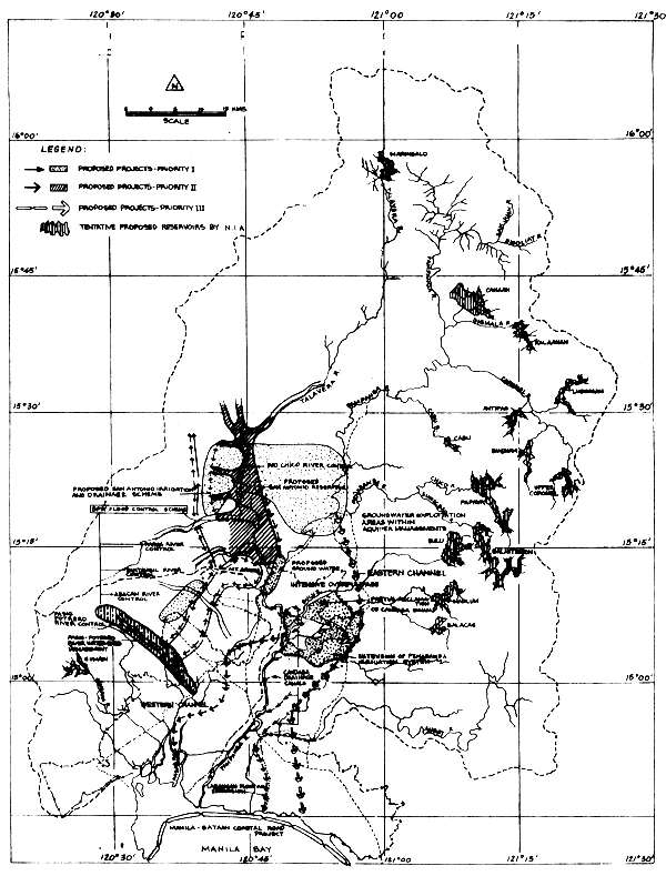
3.2.3 Another proposed project which will reduce flooding in Pampanga and Bulacan is the San Antonio irrigation and flood balancing reservoir. The project aims to collect the flows of Rio Chico River in a reservoir formed by low embankment of about 40 km long, and 1 to 9 metres high. The achievements of the San Antonio reservoir in flood control could be seen during early, off-season floods. The preliminary planned dam will incorporate a spillway which will pass flood flows from the Rio Chico River into the Pampanga River opposite the Cabiao-Candaba floodway. When the waters of the Pampanga River reach high levels, floodwaters will flow into the Candaba Swamp. Figure 3 shows the location of these proposals.
4. ENVIRONMENTAL IMPACTS OF PRESENT DEVELOPMENT
4.1 Levees, dikes and flood control projects
Levees and dikes are generally single-purpose flood protection structures built adjacent to the banks of rivers susceptible to flooding. Bank stabilization projects include such features as reduction of erosion from river banks and removal of natural growth and debris from channels to allow passage of greater flows.
4.1.1 Effects on water quality due to construction and operation
Water quality will be affected in the immediate dreding area by the action of the dredge. Increased turbidity, release of oxygen-demanding substances and heavy metals, with resulting biological ramifications, can all occur; however, a substantial return to normal conditions is expected soon after dredging has ceased.
Water quality will also be affected by the high chemical and biochemical oxygen demands associated with finely-sorted channel sediments in the project area. Resuspension of these sediments will result in temporary reduction in dissolved oxygen; however, since the oxygen requirements of estuarine organisms are basically unknown, the effects of localized dissolved oxygen reduction cannot be specifically identified. However, maintenance of the project will have no effect on the water supply of the municipalities in the study area.
4.1.2 Effects on wildlife or reduction of riparian habitat
The major effect of these dredging operations will be to kill those benthic organisms existing in the dredge sediments. These organisms will be picked up along with the dredge sediments and then burried in these sediments in the spoil disposal area. Effects on the supply of fish and benthic organisms are considered insignificant. Any effect on the recreational beach fishing, because of displacement of fish, is considered insignificant and temporary.
4.1.3 Mitigation methods for turbidity
As far as turbidity is concerned, a substantial return to normal conditions is expected soon after the dredging has stopped. Detailed data on current patterns and tidal exchange should be determined.
4.1.4 Effects of increased velocity due to channelization of flood flows
The release of water to the main water tributaries and the bay by means of cut-off channels, will circumvent some major flow bottlenecks. The designed floodway would serve to carry floods and spillover carried by the out-off and collection channel will reduce, to a large extent, potential floods originating at the east side of the project area.
4.1.5 Effect on natural drainage system
Maintaining the project will not affect existing flood-reduction or drainage characteristics of the area.
5. CONCLUSIONS AND RECOMMENDATIONS
5.1 Irrigation and drainage
5.1.1 San Antonio reservoir and irrigation scheme and drainage
The proposed San Antonio Reservoir on the site of the current San Antonio Swamp is a multi-purpose project, mainly for irrigation, flood control, possible power generation, improvement of water quality (low stream flow regulation) recreation fishing, and wildlife protection.
5.1.2 Intensification of ground water pumpage for irrigation
The overall project consists of implementation of 160 wells with a discharge rate of 300 to 350 cubic metres per hectare over a period of 5 years to ultimately serve an area of 8 000 hectares.
5.1.3 Partial reclamation and irrigation of the Candaba Swamp
This would facilitate the removal of accumulated excess surface water from a considerable portion of land during the early part of the rainy season, upon sufficient outlet and internal drains. With this, a second crop could at least be grown on a part of this area about 400 hectares on the average.
5.2 Flood control
5.2.1 Bureau of Public Works (BPW) flood control and drainage scheme
It is recommended to follow-up this scheme vigorously to realize benefits from formerly implemented structure.
5.2.2 West diversion channel
This is proposed to link the Pampanga River nearby Pasag-Candaba River to the Guagua River via a channel of about 38 km serving as alternative to the flood relief scheme of the Pampanga Candaba System.
5.2.3 East diversion channel
This is assumed to divert flood water from the Pampanga upstream from Cavino junction and intercept flood water from the Sierra Madre tributaries.
5.3 Programmes for production intensification
5.3.1 Rice intensification programme
To improve rice production considering its potentialities as well as to improve the welfare of the farmers.
5.3.2 Fisheries intensification programme
Developed fishponds in the area need intensification by proper management and operation, improvement of fish stock as well as technical aspects.
5.3.3 Erosion control and watershed management programme
Region-wide soil and land resources conservation and management programme in order to reduce erosion upstream is recommended.
6. REFERENCES
Ingle, R.M., 1952 Studies on the effect of dredging operations upon fish and shellfish. Florida Board of Conservation, Tallahassee, Tech. Ser. (5)
Palmsierna, H., 1972 The future imperative for the human environment. New York: United Nations Centre for Social and Economic Information
Planning and Project Development Office, 1976 Department of Public Works, Transportation and Communications, and Tahal Consulting Engineers, Limited, Pampanga Delta/ Candaba Swamp Area Development Project, Interim Reports I, II and III. Prepared for the United Nations Development Programme and the National Economic Development Authority.
The World Bank Group, 1972 Environmental, health and human ecologic considerations in economic development projects. Washington, D.C.: The World Bank Group
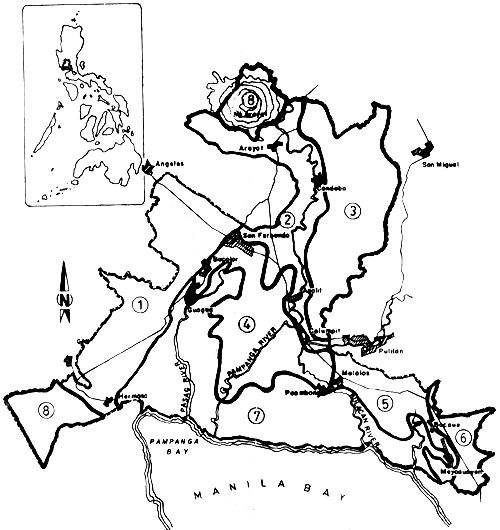
Figure 1. LOCATION MAP OF PAMPANGA DELTA-CANDABA SWAMP REHABILITATION AND DEVELOPMENT PROJECT
PRELIMINARY FRAMEWORK FOR LAND REHABILITATION AND
DEVELOPMENT
(From: Pampamga Delta/Candaba Swamp Area Development Project)
Interim Report II Volume I Text April 1976
Figure 2
MAIN FEATURES OF THE B.P.W.
FLOOD CONTROL SCHEME
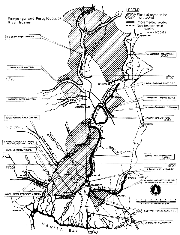
Figure 3. REGIONAL FLOOD CONTROL DEVELOPMENT PLANS AND PRIORITIES Pampanga Delta/Candaba Swamp Area Development Project
ANNEX A. SUMMARY OF LAND REHABILITATION AND DEVELOPMENT SCHEME FOR THE PAMPANGA DELTA/CANDABA SWAMP AREA DEVELOPMENT PROJECT1
| Development characteristics | Water requirements (MCM/year) | Water resources (MCM/year) | |
| Subunit 1 Angeles-Hermosa Soil Conservation and Irrigation Scheme Area: Total - 66 000 ha of which: PD/CS - 22 000 ha | Adoption of proper land use patterns according to local conditions Full-year irrigation and drainage systems Soil conservation measures | 660–750 | Reservoir 600–650 Ground water 100–150 |
| Subunit 2 Pampanga Flood Plain Irrigation and Flood Protection Scheme Area: Total - 20 000 ha of which: PD/CS - 20 000 ha | Flood control and protection Drainage systems Full-year irrigation Land use classification for rice and diversified crops according to soil suitability and capability | 225–250 | Pampanga River 130–225 Ground water 0–100 |
| Subunit 3 Candaba Lowland and Vicinity Reclamation Scheme Area Total - 65 000 of which PD/CS ha - 32 000 ha | Flood control Flood damages reduction Reclamation of inundated areas Irrigation Surface water drainage Lowering of ground water level Round-year productive land utilization Full-year paddy river and watermelons in traditional areas Permanent freshwater fishponds in lowest area | 860–1 000 | Reservoirs 750–150 Ground water 100–150 Pampanga River 0–100 |
| Subunit 4 Pampanga Delta Irrigation and Rehabilitation Scheme Area: Total - 21 000 ha of which PD/CS - 21 000 ha | River training on main and secondary channels Salinity intrusion control Quality control of water supply Soil salinity control Ground water utilization Flood retention measures to confine flooding period to minimum to achieve two short seasonal crops | 220–250 | Pampanga River 150–200 Ground water 70–100 |
| Subunit 5 Lower Angat River Development Scheme Area: Total - 40 000 ha of which PD/CS - 9 000 ha | Irrigation and drainage systems Flood relief system Salinity intrusion control Soil salinity control Upgrading water supply quality Land allocation by extension of trees and vegetables on upper areas, round-year rice and diversified crops cultivation in lowlands | Subject to Angat Development Plans | Angat River |
| Subunit 6 Urban and Industrial North Metro Manila Extension Scheme Area: Total - 6 000 ha of which PD/CS - 6 000 ha | High leveled area with undulating relief No flood problems No agricultural development; industrial and urban potential Development of local sources of water supply | ||
| Subunit 7 Permanent Salt Water Tidal Zone Area: Total - 43 000 ha of which PD/CS - 43 000 ha | Saline and brackish fish and salt farming Subject to special detailed studies | ||
| Subunit 8 Rough Mountainous Land (Not subject to development) |
1 Pampanga Delta/Candaba Swamp Area Development Project, Interim Report II,Volume 1 Text, April 1976
SCSP-SPDC/77/AEn/CP15
by
M.N. Delmendo
FAO Regional Office for Asia and the Far East
Bangkok, Thailand
1. INTRODUCTION
Floodplains are natural features of river systems in tropical and subtropical regions which are subject to yearly inundations due to monsoon rains and drying after the flood waters recede. These conditions influence the ecology of most of the riverine species found in these areas. The annual cycle of biological productivity of floodplains is associated with the migration, reproduction, and growth of freshwater species of fish such as catfishes, carps, climbing perches, snakeheads, etc. This constitutes the basis for some of the richest inland fisheries of the world (Welcomme, 1975). The floodplains during the monsoon season become a traditional communal fishing grounds. When the flood waters recede pools or lagoons of various sizes are left which become the subject of different types of exploitation.
In Bangladesh, for instance, these pools are called bheels, hoals and baors. These areas are under the control of the state revenue agency which bids or auctions to the highest bidder the seasonal fishing exploitation of such areas. The dry portion of the floodplains are used for grazing and agriculture.
In the Oúemé River floodplain in Africa, such pools dug in the floodplains are called “whedos”. These take the form of a channel which can exceed a kilometer long but not more than 4 m wide and a depth of 1.5 m. Fish are concentrated in these depressions when floodwaters recede which would otherwise escape to the river or die through the eventual drying of the floodplains. This system of flood fishery exploitation is integrated into the traditional life of the people in the Oúemé valley.
In the Philippines, the well-known floodplain located in Central Luzon, the Candaba Swamps, is under water during the monsoon period, June to November, and dry part of the year.
A unique feature of this floodplain is its ownership; most of the lands in the Candaba Swamp area are privately-owned. The land owners construct dikes to indicate their respective property boundaries. Because of the high flood water level (3–7 m high) fluctuation during the monsoon period, the entire plain is under water covering most of the property boundaries. At this stage, the floodplain is a communal fishing ground. As soon as the dikes become visible due to the recession of flood waters, the private use of the land takes over and harvesting of fish is exclusively undertaken by the land owner. When the fish have been harvested, agricultural crops are planted.
In South America, the floodplains are used almost entirely for pasture of cattle. These areas are inundated during spring by overflow of the Amazon and Orinoco River systems or by rain water. As a means of water conservation, extension dike systems of “modulos” were constructed to retain water during the dry season. The management of such areas for fish production is still under investigation.
Floodplains are evidently being managed and used for a variety of purposes, such as agriculture, fisheries and water conservation and flood control. The present methods for fish production are mostly traditional and simple which no doubt offer great possibilities for improvement and expansion, particularly for integrated agro-aquaculture production.
2. ENVIRONMENTAL CONSIDERATIONS FOR AQUACULTURE DEVELOPMENT IN FLOODPLAINS
2.1 Seasonal water level fluctuation
The annual inundation of floodplains makes these areas very productive. The soils are enriched with nutrients by their yearly flooding and the abundance of water renders the floodplains veritable grounds for fishing and extensive aquaculture production. On account of this ecological condition, the demand for other uses of floodlands besides fisheries is increasing, particularly for agricultural use. Certain areas of floodlands have already been lost due to construction of dams for irrigation, hydroelectric power generation and flood control schemes. Fisheries production in areas where such installations have been built would necessarily decrease the natural fish populations in them. The maintenance of fish production under controlled water regimes in the floodplains could be enhanced by aquaculture development.
The floodplains are under water only during certain periods of the year, from 4 to 6 months in most tropical countries. As such, the managewent of floodplains through aquaculture is one of the methods by which maximum use of the area for food production is effected. Demonstration of this technique has been successfully carried out in the Candaba Swamp area in the Philippines where agriculture and aquaculture production is alternately undertaken. A system of canals and retention dams constructed within the floodlands retains water for year-round production of fish and at the same time drains the higher portions of the land for agriculture production.
2.2 Climatic and biological cycles
Riverine fisheries production is highly influenced by the annual flood water regime. Spawning, migration and growth of natural fish populations occur mostly during the monsoon seasons when climatic conditions are predominantly rainy. As a result of this cyclic ecological condition, a sudden burst of biological productivity comes into play which constitutes the flood fisheries production in the floodplains. Extensive aquaculture activities take place by trapping the natural stock of juveniles of fish species in the floodplains, through such techniques as the dig-in depressions or “whedos” in Africa, the dike enclosures or “modulus” in South America, and property dikes in Candaba, Philippines. These activities become a matter of routine operations of people living in the floodplains as dictated by climatic conditions. There is great room for intensification of aquaculture in floodplains taking into account the biological phenomenon associated with climatic conditions obtaining in these areas. The amount of water that becomes available for fish growth in floodplains can be used to advantage by the application of aquaculture principles in the management and development of floodlands or wetlands.
3. ENGINEERING CONSIDERATIONS
3.1 Design and layout
Floodplains are generally low-lying lands that become submerged under flood conditions of river systems in which they are connected. Their submergence vary in depth depending on the topography of floodplains. Some portions may be deeply submerged, while certain areas are shallowly flooded.
Based on their topographic conditions, floodplains could be developed for aquaculture and agriculture managed either in rotation or combined operations. A typical example of aquaculture development in alternate production activities with agriculture is the type of development demonstrated in the Candaba Swamp of the Philippines.
In this particular floodplain, the main perimeter dikes serve as property line between land owners. The inner sections of the land are provided with canals and water control structures which enable the floodwater to drain out for harvesting and/or rearing fish and prepare the higher portions of the floodland to dry for agriculture production. Figure 1 shows the cross-section of the design and layout of pond/cropland in this area.
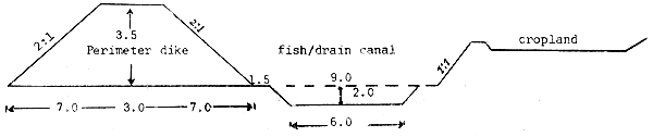
Fig. 1. Cross-section of a pond layout for rice (or water melon) - fish rotation in Candaba, Pampanga, Philippines (dimensions in m)
The dimensions of the main or perimeter dikes may vary depending on the height of water during flood periods which prevail in the area. In most instances, the main dikes are built as a road dike wide enough to facilitate passage of vehicles and high enough to prevent over topping by floods.
The canal systems constructed in floodlands follow the natural waterways in the floodland. These serve three purposes: (i) draining; (ii) retaining water for fish rearing; and (iii) for irrigation water supply. Usually, these canals are dug below the floodwater table such that water is retained in them all-year round. During the height of flood season the inner dikes become submerged such that the fish seeds reared in the fish/drain canal during the dry season disperse automatically inside the cropland area which becomes a fishpond during such period. The main or perimeter dikes are in cases constructed low so that overflooding during high floods takes place making several individual land areas into a communal fishing ground. However, as soon as the property dikes become visible when the flood waters recede, harvesting of fish becomes private. No seeding in this case is undertaken. In some areas where rice is cultivated during the dry season a small trench is dug on top of the inner dike for irrigation water supply purposes (Fig. 2). Water from the main canal is pumped as needed for rice and other crops cultivation.
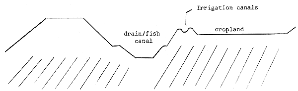
Fig. 2. Modified layout of Fig. 1
For lowlands which remain shallowly under water during the year, a modified layout is adopted such that land use could be alternatively carried out for fish/livestock/crop production.
Figure 3. Fish/livestock/crop integration
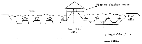
During the rainy season when the water level is high, fish is the main crop. When floodwaters recede the water concentrates in the low portions where harvesting of fish is facilitated. The elevated plots become exposed and used for vegetable production.
In some cases, water in one pond is merely transferred to the other pond for further rearing of fish during the year and devote one of the ponds for crop production during the dry period. In the subsequent year, the use of the ponds is interchanged to enable exposure and drying of the other pond which was used for fish rearing in the previous year. This technique avoids the accumulation of humus in the pond bottom.
Poultry or swine production is undertaken throughout the year. This provides adequate organic manure both for fish and crop production. The animal house is located on partition dikes between two ponds.
The above example is used in some places in Thailand where aquaculture and agriculture farming operations are integrated.
3.2 Guiding principles for aquaculture development in floodlands
Take advantage of the availability of water in floodplains and the accompanying fish seed stocks brought in by floodwaters.
Consider the physical features of the floodplains, such as topography, rainfall, and rainfall distribution, river discharge and flood levels, soil and evapo-transpiration.
Consider the optimum use of land and water available for the integrated aquaculture development of floodplains.
Consider aquaculture development in floodplains as a means of increasing overall productivity of the area.
4. MANAGEMENT OF FLOODLANDS
There are obviously many options for the development of floodlands, not only for aquaculture but for agriculture as well.
4.1 Alternate aquaculture and agriculture
Floodlands which are only partly submerged during the year can be developed and managed for alternate aquaculture and agriculture production. A typical management technique for this purpose is that which was developed in the Candaba Swamp in the Philippines. Having constructed the appropriate design and layout of ponds for this type of management, the following calendar of activities is follows:
February-May: At this time of the year, most of the land in the Candaba floodplain have been drained, fish stocks completely harvested and agricultural crop production (rice, corn or water melon) in progress. Only the drain canals retain water where fish seeds are reared for the next fish crop. The water melons and other crops are harvested during March up to May and early June.
June-October: From June to early September of each year is the time when heavy rainfall occurs. The floodplain becomes submerged and the area reverts to a fishpond. Fish seeds reared in the canals disperse in the water surface and grow with the natural fish stocks that come with floodwaters during the season. The fish seeds reared in the canals are already big and strong enough to withstand predation.
November-January: The floodwaters during this period start to recede and draining of the ponds begins for harvesting of the fish stocks. Some land owners install a big catching net to strain fish from the sluice gates. As soon as fish have been concentrated in the canals, seining is carried out for complete harvesting of fish. The canals are not completely drained to be able to stock a new batch of fish seeds for the next season.
This particular type of management is feasible in areas where heavy rainfall occurs only during certain periods of the year such as in Luzon Island, Philippines, where the rainy season lasts for about 8 months, from June to December, with peak periods in June to August or early September.
Under this type of management where semi-intensive aquaculture technique is employed, the productivity of the floodplain is increased up to 100% from natural fish production levels.
For intensive aquaculture management in this, the assurance of fish seed stocks for rearing in the drain canals is necessary. Chinese carps, milkfish and tilapia are some of the species that have been tried here. The levels of production vary depending on the skill of the operators concerned.
4.2 Integrated aquaculture/livestock/crop farming management
Lowlands that are shallowly flooded throughout the year can be developed and managed under integrated farming system. Such areas may be under water with depths ranging from 5.0 m during the peak periods of the rainy season to a low level of 0.5 m or less during the dry season.
Such lands, provided with perimeter and internal partition dikes, are utilized for fish farming during the rainy season, partly for crop production part of the year and livestock throughout the year. The pond design and layout for this type of management is shown in Figure 3.
Where the land is utilized fully for fish and livestock, the ponds are not drained unless complete harvesting of fish will be made.
In case alternate crops of fish and vegetables will be produced, the ponds are utilized interchangeably from year to year. This facilitates exposure of the pond bottom to sunlight thereby breakdown of accumulated organic materials is facilitated.
This type of management renders a lowland area unproductive which would otherwise remain marginal if only extensive aquaculture by trapping of natural fish seeds are made.
4.3 Combined aquaculture and agriculture development
Marginal lands such as the marshy lowlands in Israel unfit for agriculture production are developed mainly for water retention and fish farming. The ponds are often dug deep enough to accommodate water for irrigating the nearby croplands, such as cotton fields, and at the same time facilitate the rearing of fish during the year.
Irrigation water is obtained from the ponds by partial draining into the drainage canal where water pumps are installed to distribute the same to the croplands adjoining the fishponds. After taking water from the fishponds for irrigation, enough depth of water for fish rearing is left until the fish stocks are harvested. The drainage canal is also utilized as water storage when the ponds are drained for harvesting. The same water is returned to the ponds for subsequent fish production.
In all the above three types of floodland use and management techniques, it is very important that facilities for water supply and control be adequately provided in order to create an environment that is favorable to fish growth.
The design and construction of these facilities vary depending on the amount of water to be handled. Sluice gates of double or triple openings made of concrete are typical structures constructed for water control and supply purposes; concrete culvert pipes are also utilized in some areas while in other situations pumping of water is resorted to particularly in draining ponds located in very low areas.
5. PROBLEMS
5.1 High cost of seepage
Usually floodlands are located in the depression areas or interior deltas of river systems. As such, the fluctuation of the water table in the floodplain is regulated by the level of water in the river system. Seepage is often very high in these areas which often poses problems in the provision of the necessary water control structures. The best approach therefore is to rear fish only during the wet season when abundant water supply is available.
5.2 Water resources use policy
The development of floodplains for fish farming is dependent on the overall water resources use policy in the area and the flood control measures adopted in the river system. Aquaculture development is often neglected and taken for granted in most water resource development planning. This is mainly on account of the lack of technical know-how on aquaculture principles and the lack of supporting data on aquaculture production in floodplains.
5.3 Socio-economic
Floodplains are often used as communal fishing grounds by people dependent on this resource for livelihood. In fact, the use of these marginal areas has become traditionally integrated in the rural life of people living in floodplains.
The development of floodlands for aquaculture or agriculture production often leads to the dislocation of these rural people which lead to social and economic disorders in the area.
Any development plans intended for the use of floodplains, whether this be agriculture or aquaculture should take into consideration the social and economic implications on communities established in floodplains.
6. RECOMMENDATIONS
The use of floodplains for fish production is gradually gaining more interests worldwide. The reason is obviously on account of the rising demand for more and more food for the ever-growing population in the developing countries.
There are positive indications for better management and development of floodlands for fish production which could be carried out hand-in-hand with agriculture and animal husbandry. On the other hand, such development should not lose sight of the overall land and water resource use for the benefit of rural communities dependent on floodlands for subsistence.
There are certainly technical, social, economic and political aspects to consider in the management and development of floodplains. An overall review and examination of these aspects should be made to arrive at a rational land and water use programme, particularly in respect of the floodplains.
Many options for management and development of these areas have been presented in this paper. However, it is felt that more technical and economic data would be required to serve as basis for the formulation of national policy measures regarding floodlands development for food production in general and aquaculture in particular.
Bench mark information on natural productivity of floodplains is indeed wanting. Considering the great potentials for increasing fish production in these areas, such basic data are vital for future development plans.
Floodplains are usually considered marginal lands or wastelands for the simple reason that they are often classified as unfit for agriculture use. On the other hand, simple and traditional engineering principles applied by rural people have shown the usefulness of floodlands for extensive aquaculture as well as agriculture operations. The improvement of existing practices by the application of sound engineering principles that would facilitate optimum use of land and water resources in floodplains would render these areas more suitable for increased fish production.
7. REFERENCES
Delmendo, M.N., 1967 Lowland fishponds in the Philippines. FAO Current Affairs Bulletin
Tang, Y.A., 1976 Physical problems in fish farm construction. FAO Technical Conference on Aquaculture, Kyoto, Japan, 26 May–2 June 1976. FIR/AQ/Conf./76/R.15: 10p.
Tapiador, D.D., et al, 1977 Freshwater fisheries and aquaculture in China. A report of the FAO Fisheries (Aquaculture) Mission to China, 21 April–12 May 1976. FAO Fish. Tech. Pap., (168): 84p.
Welcomme, R.L., 1976 Extensive aquaculture practices on African floodplains. In Symposium on Aquaculture in Africa, Accra Ghana, 30 September–2 October 1975 (1976). CIFA Tech. Pap. (4), Suppl. 1: 248–52
SCSP-SFDC/77/AEn/CP28
by
A.R. Gatus and E.S. Martinez
Bureau of Fisheries and Aquatic Resources
Metro Manila, Philippines
1. INTRODUCTION
Mangrove swamps are part of public domain within the tidal flat along sea coast extending along streams reached by tidal water, partly or totally covered with vegetation called “mangrove forest”. Delineation on how far this mangrove extends cannot at the moment be defined and resolved.
The country recognizes the potential value of this mangrove resource and the need to properly allocate this area for its multiple socio-economic uses while considering their ecological implications.
There are three competing forces on this resource: the forester, who wants to utilize the trees; the fish farmer, who wants to convert sites into fishpond; and the environmentalist, who would like the area for ecological stability. The pressures on the mangrove resource will continue to persist until all varied uses of this resource can be satisfied without sacrificing conservation and ecological balance. Present studies across a broad spectrum of subjects and activities dealing with mangrove areas for development have not been fully and extensively analyzed, reviewed and evaluated as a basis for the formulation of a unifying and integrated legislation or policy. Existing policies on mangrove resources development are fragmented and isolated, thus contributing to the improper exploitation, conservation and management of the same.
This paper is an attempt to consider engineering in the release of mangrove swamps for development into fishponds.
1.1 Area of mangrove swamps
The extent of mangrove swamps in the country varies and presently there are three statistics available. The Bureau of Forest Development (BFD) in 1975 show that the Philippines has a total of 254 016 hectares of mangrove forests. The same source indicates that there are 116 876 hectares in Mindanao; 66 982 hectares in the Visayas; 41 779 hectares in Palawan; and 28 199 hectares in Luzon.
The Bureau of Fisheries and Aquatic Resources (BFAR), on the other hand, in its 1976 Fisheries Statistics indicated that there are still about 400 890 hectares of mangrove areas. Among the 12 regions of the country, Region VIII (Leyte and Samar) has the most extensive mangrove area with 120 521 hectares.
The National Resources Management Center (NRMC) based on their forest inventory estimated that there are still about 106 133 hectares of mangrove forest remaining in the country or about 0.35% of the total forest area. The survey shows that Mindanao has the most extensive mangrove forest with 39 810 hectares; Palawan 34 853 hectares; Visayas 13 845 hectares; Luzon 10 924 hectares and Mindoro 6 701 hectares.
To reconcile these figures, the National Symposium/Workshop on Mangrove Research and Development held on 28–30 July 1977 states that the Philippines has about 400 890 hectares of mangrove ecosystem of which 100 000 to 200 000 hectares are covered by mangrove forest of Rhizophora, Avicennia and associated species.
1.2 Area developed into fishponds, annual production and value
The BFAR statistics for 1975 indicate that there are a total of
176 032 hectares of mangrove swamps converted into brackishwater fishponds
in which 49% are privately owned and 51% are under government lease. Luzon
has the biggest area of developed fishpond, followed by Visayas in which the
biggest area is in Western Visayas. Low productivity regions are Bicol,
Central Visayas and Western Mindanao regions. The annual fish production
from fishponds amounted to 112 760 metric tons valued at 845 704 000. This
indicates a national average fish yield of 640 kg per hectare in 1975, still
way below the attainable production of about 2 000 kg/ha/year achieved by
the more progressive fishpond operators.
1.3 Area developed or being utilized for other purposes
There is insufficient record as to the extent of developed mangrove swamps being utilized for other purposes aside from fishpond purposes. The Bureau of Forest Development claimed that there are only two mangrove timber licenses both in Luzon existing as of June 30, 1975, covering an area of 9 455 hectares with an allowable cut of 47 181 cubic metre. Different municipalities, however, are continuously granting municipal licenses for the exploitation of mangrove tree species. The Bureau of Forest Development statistics also indicate that during the period between 1967 and 1975, a total area of 194 284 hectares have been deforested for various uses, that is, for firewood, bark, fishponds, human settlement and other purposes.
There are, however, developed mangrove swamps that are being utilized to solar saltworks in Luzon and Visayas but are mostly utilized into fishponds during rainy season. This area is not so extensive as salt making is only favourable to Type I weather condition in the Philippines.
1.4 Area potentially suitable for development
The criteria presently adopted in the disposition of mangrove areas for fishpond purposes indicate that most of our mangrove swamps can be potentially developed into fishponds. The characteristics of a swampland to meet these criteria are: swampy areas or tidal flats, no extensive mounds or elevations and depressions in topography, site elevation should at least range from 0.3 to 1.2 metres about the zero datum or mean lower low water mark; without vegetation nor thickly wooded with big trees, or at least with small growth that are easy to clear; steady supply of both fresh and brackishwater throughout the year; capable of being drained when necessary; suitable soil for fishponds (clay, clay-loam and sandy-clay); free from flood hazards; and availability of input such as fish fry, feeds and fertilizers, as well as skilled manpower near the site.
Based on the mentioned criteria, it is estimated that 60% to 70% of the mangrove swamplands not alloted for forest purposes are potential areas for fishpond development unless otherwise designated for conservation and ecological stabilization purposes.
2. PROCEDURE FOR RELEASE OF MANGROVE SWAMPS
2.1 Enabling act or order authorizing release
The Bureau of Forest Development under Republic Act No. 4715 is the agency of the government that classify, zonify and survey public domain including mangrove swamps for the past years until a committee was created to undertake the survey, identification, classification and zonification of public forest land for fishpond development under Special Order No. 502 dated October 29, 1973 of the Department of Agriculture and Natural Resources. The National Fishpond Development and Survey Committee created pursuant to the said DANR Special Order was composed of the Director of the BFAR as Chairman and the Assistant Directors of both the Bureau of Lands and Bureau of Forest Development as members. The survey, classification and zonification of mangrove forest under Special Order No. 502 went on until the creation of the Land Classification Committee under Department Order No. 3, series of 1975 of the newly-created Department of Natural Resources. The composition of the Land Classification Committee has the Director of Forest Development as Chairman and the respective Directors of the BFAR, Bureau of Lands and Bureau of Mines as members.
2.2 Principle involved in releasing mangrove swamps
Pursuant to Presidential Decree No. 705 dated May 19, 1975 known as “The Revised Forestry Code of the Philippines”, the Secretary of the Department of Natural Resources is given the authority to study, devise, determine and prescribe the criteria, guidelines and methods for the proper and accurate classification and survey of all lands of the public domain including mangrove swamps into agricultural, industrial or commercial, residential, resettlement, mineral, timber or forest, grazing and fishponds and into such other classes. The Land Calssification Committee assisted the Secretary of the Department of Natural Resources in the promulgation of rules, regulations and guidelines for the classification, survey and zonification of all lands of the public domain. It also created several composite Land Classification Teams deployed all over the country to determine what portions of public forest should be retained for forest purposes and what portions should be released for agriculture, fishpond and other purposes.
Swampslands that are declared available for fishpond development by the Bureau of Forest Development, through the Land Classification Committee, are released to the BFAR for administrative disposition. Applicants wishing to lease mangrove swamps are required by the BFAR to submit a project feasibility study to develop the area and make it productive at optimum levels. This is in line with the government's concept of “managed disposition” of the country's fishery resources. A qualified and interested applicant after fulfilling all the requirements is granted a lease for a period of 25 years renewable for another 25 years. The lease contract gives him 5 years to develop the fishpond into commercial-scale, otherwise the underdeveloped portion is declared open and vacant to other qualified and interested applicants. For failure to develop or abandonment of the leased area, the lease agreement is cancelled and the area declared open and vacant to other interested applicants or reverted to the public domain. Through this management concept, the development of mangrove swampland for fishpond is assured within a given time and the practice of speculation is contained.
2.3 Forest conservation viewpoint
Mangrove swamplands are among the most naturally fertile and biologically productive areas of the estuarine ecosystem and portions should be conserved as a large area of our mangrove swamps has already been converted into fishponds and other land uses. Available data from 1967 to 1975 indicate that mangrove forests are deforested at the rate of 24 285 hectares annually. The implication of these activities on the ecological balance has been emphasized. Apart from down-grading optimal forest utilization, the biological system dependent on the ecosystem will be dislocated, commercial fish yield will dwindle, soil erosion on shorelines will go unimpeded, and coastal swamplands exposed to store surges.
There is a need to protect and maintain the mangrove forests, rehabilitate them in threatened areas through reforestation, afforestation and industrial plantations. To safeguard the marine animal inhabitants of the mangrove ecosystem, mangrove parks and mangrosetum should be established. To gain the proper management perspective in disposing mangrove areas, their zonification for various uses must be based on the rational analysis of the multi-factors involved.
2.4 Food production viewpoint
Aquaculture plans an important role in the production of cheap animal-protein food, an important item in the Filipino diet. As a major protein source, fish have not been produced in sufficient quantities to meet the needs of the fast growing population. The BFAR put emphasis to the Expanded Fish Production Program to accelerate the pace of fish production in order to meet the effective demand requirement and produce some surplus for possible export.
The strategy used is increasing the yield of existing fishpond per unit area as well as increasing the unit area of fishponds. The incremental production target assigned to the Brackishwater Fisheries for 1977 is 14% which is some 10 800 metric tons more than the previous year fishpond production. While it is true that intensifying fishpond production will increase the total fish production, still this strategy is of short duration and cannot be used solely to supply the protein requirement of the ever expanding population. While supporting the conservation of the mangrove and estuarine areas to preserve a balanced ecosystem, the productivity of the same is limited to satisfy the requirements of sustenance fishermen. The problem therefore arises on what will be the percentage of mangrove areas to be allocated for aquaculture and what percentage should be conserved for posterity.
2.5 Resolution of conflict - power of decision
The Secretary of the Department of Natural Resources (DNR) has the power to decide conflict on the classification and zonification of the public domain. Mangrove swamps reserved for communal forest and found to be suitable for fishpond purposes based on the guidelines set forth under Department Order No. 3, series of 1975, by the composite Land Classification Team, require the de-establishment by the Secretary of DNR. He has the authority to declare those classified, zonified and determined not needed for forest purposes as disposable lands. Public domain classified as A and D for agriculture shall be transferred to the administrative jurisdiction of the Bureau of Lands and if zonified for fishpond shall be transferred to the BFAR for administrative jurisdiction and management. Mangrove swamps may be released by the Secretary of the DNR to the BFAR for administrative disposition if they are already logged over or denuded of mangrove forest while under concession, license or permit, found to be suitable for fishpond development by the composite Land Classification Team.
In determining the priority right of fishpond applications, the following rules are observed (FAO 60–4, Sec. 14):
When two or more applications are filled for the same area which is unoccupied and unimproved, the first applicant shall have the right of preference thereto.
Between an applicant for a bona fide occupant of an area available for fishpond purposes, the latter shall have the right of preference to the said area, in which case, the actual occupant, if qualified, shall be advised by the Director of BFAR to file a fishpond application within thirty (30) days from his receipt of a notice to that effect. If the occupant is not qualified under the law to apply for fishpond application within the time granted above, he shall be required to vacate the premises.
If two or more applications are filed for the same area on the same date, the applicant who can best meet the requirements of the fisheries law and regulations based on financial capacity and/or qualifications, shall have the right of preference thereto.
3. ENGINEERING CONSIDERATIONS
3.1 Suitability of site
Not all mangrove swampland areas are suitable for fishpond development. Although in most cases they may be technically feasible for development into fishpond, but if the cost for its conversion will entail great expense and its management will be difficult, these swampland areas should not be released for the project may not be financially and economically viable to undertake.
Mangrove areas whose elevation falls outside the range of 30 cm to 160 cm above the mean lower low water appear to be unsuitable unless some excavations could be made, some filling can be done in the area, some mechanical pumping will be employed and some increase in number and size opening of water control structures are added. This will however, entail considerable expenses.
Some mangrove areas are still forested by big mangrove trees. While these areas can be cleared of vegetation and developed for fishponds, the very slow process of getting the area into productive stages negates development of such areas for brackishwater aquaculture.
Topography of some mangal areas appears to be undulating. This is attributed to the presence of excessive Thalassinus mounds which renders such area relatively high. Considering that excavation and levelling will be necessary to make such area productive, areas with excessive earth mounds may not be suitable for fishpond development.
Mangrove swampland where the soil is sandy and rocky are not suitable for fishpond purposes. Dikes constructed of these materials will not permit efficient control of water within the pond system. Furthermore, mangrove areas which have thick layers of peaty soil with undecomposed organic matter tend to have an acidic bottom. These types of mangrove areas are also unsuitable for fishpond purposes.
Mangrove areas that are relatively far from the sea and are greatly influenced by the floodwater coming from a big watershed should closely be studied. Putting up of bigger and higher dikes and construction of water diversion canal may be expensive especially if the proposed fishpond project is only a small one. Development cost may not be economically feasible. In addition, mangal areas with scanty soil cover are also unsuitable for the same reason of difficulty in minimizing flood hazard and the destruction of proposed main dikes.
3.2 Status of area as forest
The continuous cutting of trees in the mangrove swamps by the people for firewood and for housing materials in addition to the wood cutting by the permittees and concessionaires for commercial purposes renders majority of our mangrove swamps already logged over. If there are primary trees in the mangrove swamps remaining, majority are Avicennia sp. which has less commercial value, not even good for firewood nor for housing materials. It is only in the provinces of Palawan and Zamboanga del Sur where portions of the mangrove swamps are still covered with primary trees. If there are mangrove swamps still with good residual stock, they are mostly under concession, permit and under communal forest.
In the development of brackishwater fishponds along swamplands, the law provides that a strip of at least 40 metres wide along shorelines facing rivers, lakes and other bodies of water, and a belt or strips of not less than 100 metres facing bays or the sea excluded from fishpond development to protect the shoreline from destructive force of the sea, high winds and typhoons. These strips of mangrove forest bordering bays and seas cannot be alienated or cleared to operation purposes as long as they are not declared alienable and disposable lands of the public domain.
Under Presidential Decree No. 950, every holder of a lease agreement is under obligation to plant trees, extending at least 20 metres from the edge of river banks and creeks. Under the same decree, any person who cuts, destroys or injures naturally growing or planted trees of any kind in this area without authority from the government agency concerned is liable for a fine and/or imprisonment.
3.3 Socio-economic considerations
In the development of the mangrove areas, whether it be for forestry, fisheries, agriculture, human settlement, industries, ecology and others, they are presumably done ultimately for the welfare of the people. In some areas, a large portion of the village population rely to a considerable extent on mangrove and its resources, both socially and economically. With a rapidly expanding population, the pressure for the utilization of these resources is now greatly felt.
While supporting the conservation of the mangrove and estuarine areas to preserve a balanced ecosystem, the authors believe that the productivity of the same are limited to satisfy the requirements of sustenance fishermen, the poorest segment of our people. There is a need to develop portions of our mangrove resources for small-scale aquaculture to elevate these artisanal fishermen from the bondage of poverty.
Small-scale aquaculture brings tangible benefits to the artisanal fishermen by providing direct employment; produce fish to supply the much needed protein requirement and further bring its price to a level within the reach of the Pilipino people; and help ease the drain of foreign exchange for the importation of fish and other fishery products.
There are inadequate technical data to backstop managed development of mangrove areas for forestry, agriculture and other related fields unlike fisheries. Technology in aquaculture is continuously being developed and from present-day technology, it is clearly demonstrated that it is profitable to utilize suitable mangrove areas for fishpond development.
3.4 Government guidelines
Department Order No. 3 which is in conformity with the provisions of some sections of Presidential Decree No. 705, otherwise known as “The Revised Forestry Code of the Philippines” promulgates rules, regulations and guidelines in classifying mangrove areas for forest or fishpond purposes. The following areas are retained as forest lands:
Areas needed by the people for their domestic needs for nipa and firewood and industries dependent on firewood, charcoal and tanbark;
Areas needed for bank and shore protection;
Areas still covered by trees and cutting licenses although suitable for fishpond development purposes;
Swampy areas suitable for game refuge and bird sanctuaries;
Areas needed for forest station site;
Areas covered by existing Other Lawful Purpse (OLP) permits except those areas covered by salt-works permits and fry grounds which should be zonified for fishpond purposes.
Alienable and disposable areas may be used for fishpond purposes if the following conditions are satisfied:
Topography - swampy areas or tidal flats where there are no extensive mounds or elevations and depression. The site should be at least on elevation ranging from 1 to 4 feet (0.3 – 1.2 m) above zero datum;
Vegetation - areas without vegetation or areas with small growth that are easy to clear instead of areas thickly wooded with big trees;
Water supply - there should be a steady supply of both fresh and brackishwater throughout the year;
Drainage - the site should be capable of being drained when necessary;
Soil - clay, clay-loam and sandy-clay;
Freedom from flood - the site should be free from flood hazard;
Other factors - availability of input such as fish fry, feeds and fertilizers as well as skilled manpower.
Majority of our swampland areas, based on the following guidelines can qualify for fishpond development as previously stated. However, suitability of site based on engineering and fishpond management considerations as previously stated should be given emphasis for the fishpond project to succeed and be economically profitable.
3.5 Environmental considerations
Pursuant to the provisions of Presidential Decree No. 1151, dated June 6, 1977, known as “The Philippine Environmental Policy”, all agencies and instrumentalities of the national government, including government-owned or controlled corporations, as well as private corporations, firms and entities shall prepare, file and include in every action, project or undertaking which significantly affects the quality of the environment, a detailed statement on:
the environmental impact of the proposed action, project or undertaking;
any adverse environmental effect which cannot be avoided should the proposal be implemented;
alternative to the proposed action;
a determination that the short-term uses of the resources of the environment are consistent with the maintenance and enhancement of the long-term productivity of the same; and
whenever a proposal involves the use of depletable or nonrenewable resources, a finding must be made that such use and commitment are warranted.
Before an environmental impact statement is issued by a lead agency, all agencies having jurisdiction over, or special expertise on the subject matter involved shall comment on the draft environmental impact statement made by the lead agency within 30 days from receipt of the same.
Although at the moment there is no definite and specific guidelines on mangrove areas that can be utilized for fishpond development, taking into consideration the “Environmental Impact Statement” (EIS), it is presumed that leasing of mangrove areas for fishpond development may encounter some difficulties and delays. It is hoped that a just and lasting solution to this problem can be found immediately whereby all sectors of the community will be happy and contented in the environment where we all live.
4. CONCLUSIONS AND RECOMMENDATIONS
4.1 While supporting the conservation of the mangrove and estuarine areas to preserve a balanced ecosystem, the productivity of the same is limited to satisfy the requirements of sustenance fisheries. Early resolution on what percentage of the mangrove areas will be allocated for aquaculture and what percentage should be conserved for posterity is urgently felt for a more rational aquaculture planning and development to meet the protein requirement of an ever expanding population.
4.2 Mangrove swamps adjacent to agricultural areas and to be utilized for fishpond should provide a buffer zone of at least 20 metres to 50 metres for the drainage of floodwaters from the watershed. This will serve as protection against flood of the proposed fishpond project as well as for conservation of mangrove resources.
4.3 Mangrove swamps close to the sea, bays and gulfs that are used as salvage zone to protect the shoreline from the effect of high winds and waves should be temporarily reserved as timberland. If soil accretion is substantial and mangal formation is extended, additional portion of the swampland may be used for aquaculture in the future.
4.4 Mangrove areas that are relatively far from the sea and are greatly influenced by the floodwater coming from a big watershed should be avoided for aquaculture. Development of such area for aquaculture may entail great expense and render it financially unviable.
4.5 Mangrove areas which are near steep mountain ranges with scanty soil cover are also unsuitable for aquaculture development. To contain floodwater coming from a steep elevation is difficult and expensive to undertake and may not be economically viable especially if the proposed aquaculture project is relatively small.
4.6 Zonified mangrove areas for aquaculture development need a zonal planning considering the environmental implication before releasing to the respective aquaculture developers. Presently, mangrove areas are released to individual applicants without due consideration on the zonal development of the area. This proposed approach will harmonize the interest of the aquaculture developers and the conservationists.
5. REFERENCES
Bureau of Fisheries and Aquatic Resources, 1977 Fisheries Statistics of the Philippines. BFAR, 1975: 115p.
Philippine Government, 1977 Proceedings (Provisional), National Symposium/ Workshop on Mangrove Research and Development. Metro Manila, Philippines, 28–30 July 1977
Rabanal, H.R., 1977 Forest conservation and aquaculture development of mangroves. Contributed to the Workshop on Mangrove and Estuarine Area Development for the Indo-Pacific Region, Manila, Philippines, 14–19 November 1977: 12p.
SCSP-SFDC/77/AEn/CP30
by
A.S. Camacho
University of the Philippines, College of Fisheries
Diliman, Quezon City and
NSDB/UP Inland Fisheries Project, Brackishwater Aquaculture Center
Leganes, Iloilo, Philippines
1. INTRODUCTION
In the course of investigating possible causes for an unexplained fish kill during the first experiment conducted in the new ponds of the Brackishwater Aquaculture Center at Leganes, Iloilo, our researchers discovered that the ponds are seriously affected by acid sulfate soils. These are characterized by a high-content of sulfidic compounds that produce acidity on oxidation. The acidity in turn releases levels of aluminum and iron that may be toxic to pond biota. Although such soils have been studied extensively relative to reclamation for rice production, they generally had not been recognized in connection with fish culture until the problem was brought to light by BAC researchers (IPF, 1974; Potter, 1976). Since then the significance of these soils has been recognized. Tang (1976) reported at the world symposium on aquaculture that 60% of Philippine fishponds are affected by acid sulfate soils. Although occasional fish kills are caused by these soils in acute situations, chronic, sublethal effects that inhibit pond biota in general probably are the more detrimental influence in the long run. This soil condition results in poor fertilizer response, particularly in the case of phosphorus. The high phosphate-fixing capacity of acid sulfate soils probably explains the observation that phosphorus fertilizer gave essentially no response in BAC fertilization trials (Table 1).
The recognition of the problem acid sulfate soils pose for aquaculture has implications that extend far beyond the Philippines. Mangrove swamplands and similar areas provide ideal conditions for the formation of acid sulfate soils and these are the areas in which brackishwater fishponds generally are built. Under the pressure of increasing demands for food, it is inevitable that some of the world's remaining mangrove areas will be targeted for aquaculture use.
2. IDENTIFICATION OF ACID SULFATE SOILS
We are now pursuing a research program in Leganes to test, among others, various methods of identifying present or prospective fishponds affected by acid sulfate soils (see Appendix “A”). A simple technique has been found effective for determining total potential acidity. The method involves the incubation of moist soil samples for a period of 30 days inside thin (permeable) plastic bags. The pH of samples with large reserves of potential acidity dropped to 4.0 or less during the specified incubation period. During tests of acid sulfate soils at the BAC there was a four-fold increase in total potential acidity and oxidizable sulfur from the surface to a depth of 100 cm (Table 2) attributed mainly to the leaching of the surface soil. This finding on the local soil conditions at BAC is now being used in connection with the construction of our additional fishponds. The non-acid top soil which was scraped off and piled up in a section of the site will be spread over the pond bottoms following excavation. The analytic procedure recommended by the BAC will help fishfarmers, at least, by alerting them to the possible high cost of soil improvement before even investing in pond construction.
3. REMEDIAL MEASURES
We have preliminary evidence that leaching, liming, and heavy application of organic fertilization can improve acid sulfate soils. Twenty 500 m2 ponds were tilled to speed up oxidation of soil sulfur to a soluble form, then were subjected to tidal flushing and washing by rain water during the wet season to leach away undesirable sulfates and metal ions, e.g., aluminum and iron. Subsequently, the same twenty ponds received different rates of lime and chicken manure (Table 3). There was marked improvement in total fish production in ponds that received lime compared with the unlimed controls. Also there was an indication of synergism between lime and level of organic fertilization. Both observations will be studied further.
4. CONTROL OF DIKE EROSION
Erosion of the dikes is another problem associated with acid sulfate soils, because of the scarcity or total absence of covering vegetation. Erosion of fishpond dikes has a number of serious results. Sulfate containing soil particles when washed by rains into the fishponds result in the formation of sulfuric acid that can cause increased water acidity (Dunn, 1965). Also, the turbidity caused by this runoff impairs photosynthesis and interferes with fish respiration. Furthermore, the resulting siltation poses a severe problem concerned with water management. Removal of silt is expensive and will become a cumbersome operational expense on a continuing basis.
We tested eight (8) species of plants that were recommended to us by a forage specialist at UP Los Baños, and finally chose Cynodon dactylon (common name: Bermuda grass). A method of ground preparation and planting technique were devised and found satisfactory by actual testing. They consisted of: 1) Tilling the soil by rakes and shovels to a depth of 5 cm; 2) Liming with agricultural limestone at the rate of 7 tons/ha followed by fertilization with 5 tons/ha of chicken manure and 350 kg/ha of inorganic fertilizer (14–14–14); 3) Covering the plots with approximately 5 cm of rice straw mulch; and finally. 4) Planting cuttings of grass in the plots at 30 cm intervals.
Last year, the station implemented a successful grass planting programme based on the procedures mentioned above. However, before further expansion of this programme, we are now in the process of examining our present methods in order to determine whether they can be improved from the standpoint of cost effectiveness.
Table 1. Total harvest weights (bangus plus wild species) from 46 500 m2 earthen ponds stocked with 3000 bangus per ha that were reared for 6 months under different fertilization and water management regimes; i.e., lab-lab and plankton. All values in kg/ha.
| Treatment1 | Lab-lab | Plankton |
| N | 623.0 | 475.5 |
| CN | 514.0 | 826.7 |
| CNP | 424.0 | 721.3 |
| CP | 878.3 | 341.4 |
| NP | 339.5 | 451.7 |
| C | 468.0 | 312.3 |
| U | 346.5 | 190.8 |
| P | 382.5 | 172.5 |
| Means | 497.0 | 437.3 |
Table 2. Soil characteristics obtained from the site of the proposed BAC one-hectare ponds
| Characteristics measured | Depth (cm) | |||
| 0–25 | 25–30 | 50–75 | 75–100 | |
| Organic matter, % | 2.92 | 2.44 | 3.21 | 3.63 |
| Sulfur, % | 0.41 | 1.00 | 1.41 | 2.04 |
| Total Potential | ||||
| Acidity | ||||
| (meg H+/100 g) | 10.3 | 24.3 | 33.2 | 39.2 |
Table 3. Total production in ponds given different levels of chicken manure and lime inputs following tilling and repeated leaching (culture days: 120; stocking rate: 3000/ha)
| Treatment | Present Production (kg/ha)1 | Previous Production (kg/ha)2 |
| I - no lime; 2 tons/ ha chicken manure | 419.3 | 336.5 |
| II - 8 tons/ha lime; 2 tons/ha chicken manure | 565.6 | 402.7 |
| III - 8 tons/ha lime; 8 tons/ha chicken manure | 805.0 | 412.2 |
| IV - 4 tons/ha lime; 2 tons/ha chicken manure | 555.4 | 478.5 |
| V - 4 tons/ha lime; 8 tons/ha chicken manure | 929.8 | 689.0 |
1 After tilling and leaching
2 Before tilling and leaching
Appendix “A”
BRACKISHWATER AQUACULTURE CENTRE
University of the Philippines System
Leganes, Iloilo
RESEARCH PROGRAMME ON ACID SULFATE SOILS
Identification of the Problem
Location and characterization of soil types for use in experiments
Study of the chemical changes that occur upon drying acid sulfate pond soils
Study of the chemical changes in the soil and water upon flooding
Availability of macronutrients
Silica
Availability of micronutrients
Cobalt
Investigation of possible toxic factors
Manganese
Development of Management Procedures to Improve Fish Production in Acid Sulfate Fishponds
REFERENCES
Dunn, I.G., 1965 Notes on mass fish death following drought in South Malaysia. Malaysian Agric. J., 45(2): 204–11
Inland Fisheries Project, 1974 Causes of bangus kills in ponds at the Brackishwater Aquaculture Centre following a heavy rain. UP College of Fisheries, Tech. Rep. (5)
Potter, T., 1976 The problems to fish culture associated with acid sulfate soils and methods for their improvement. Report of the ASEAN Seminar/Workshop on Shrimp Culture. 15–23 November 1976, Iloilo City, Philippines: 10p.
Tang, Y.A., 1976 Physical problems in fish farm construction. FAO Technical Conference in Aquaculture, Kyoto, Japan, 26 May-2 June 1976. FIR:AQ/Conf./76/R15: 10p.
![]()
![]()
![]()