![]()
![]()
![]()
by
Eladio S. Martinez1
ABSTRACT
The layout and design of a fish farm is the most basic and significant aspect in aquaculture development. The important role of aquaculture engineering is to fulfill the biological engineering requirements of the fish farm to attain its objectives.
In planning a fish farm, set the criteria involved and prepare at least two or more layout plans as basis of study and analysis to be able to come up with a design for a viable project. There are different types of layout and designs of fish farms based on criteria and objectives of projects.
1. BACKGROUND
In 1965, when the UNDP/FAO and the Philippine government with BFAR as lead agency implemented the Inland Fishery Biology Project (PHI/68/018), emphasis was shifted to fish culture in brackishwater fish farms. In this project, this writer was assigned as technical assistant to the UNDP/FAO Inland Fishery Biologist in the preparation of layout and design of aquaculture projects for both government and private sector fish farms.
Fishpond engineering was made a part of the Fish Culture Development Project. Dr. Yun-An Tang, UNDP/FAO Inland Fishery Biologist of the Project initiated the modernization of pond design at that time.
In 1969, under UN/FAO fellowship, opportunity was afforded to observe and study fishpond engineering and management in the United States, Israel and Taiwan. In the United States and Israel emphasis on the observation and study was on freshwater fish farm engineering, while in Taiwan both freshwater and brackish-water fish farm engineering were observed. Later in 1980, in Burma experience was gained as freshwater aquaculturist consultant of the Second ADB-funded Fisheries Development Project where layout and design of a freshwater fish farm project was part of the job (Figure 1).
It is a known fact that initial investment in the fish farm industry is high and only people with enough capital can go into this type of venture. Failure of the physical structures of the fish farm project means loss of capital and one of the primary factors of failure is due to poor layout and design of the fishpond.
The layout and design of an aquaculture project will show how it would look when constructed. Farm layout and design is the most basic and significant aspect of fish farm development. In aquaculture projects, the function of each physical structure and facility and their interrelationships are taken into consideration to assure efficient and effective fish farm management and operation. Another consideration in the layout and design of a project is to minimize development and maintenance costs with maximum production attainable. In planning fish farm projects conservation measures should also be given due consideration for the ecological balance of marine life as well as for the protection of the project itself.
2. FACTORS TO CONSIDER IN PLANNING LAYOUT AND DESIGN OF FISH FARMS
The layout and design of fish farm projects are greatly influenced by a number of criteria. Among these physical characteristics which affect the layout and design of fish farms are the size, shape, topography, geographical location of the area, condition of the watershed, tidal fluctuation, wind direction and wind velocity, and climate and weather in the area where the fish farm project is located.
2.1 Size aspect
Generally, small area has simple layout, however, bigger areas are easier to plan. Pond size and gate requirements can be apportioned properly.
2.2 Shape aspect
Generally, it is difficult to design and have an ideal rectangular pond in irregularly shaped fish farm sites. Mostly irregular-shaped ponds are designed in irregular areas.
2.3 Topography
It is very difficult to find fish farm sites which are practically level. There is a degree of variation due to the topography of sites. It is generally common to find that portions near the river banks are slightly lower than portions which are adjacent to upland areas. Fishpond construction costs to some extent can be minimized in designing the pond compartment by taking advantage of the difference in topography of sites.
2.4 Condition of the watershed
The amount of run-off water coming from the watershed influences the height and slope of the perimeter dike and the design of the fish farm in general in order to protect the farm from the destructive effects of the floodwater. Liberal allowance or selvage zone from the river banks and diversion canals adjacent to upland areas should be provided. Consequently, the fish farm area has to be reduced which otherwise could have been different if the watershed is small and cannot cause high floodwater.
2.5 Wind direction and velocity
The two prevailing winds which influence Philippine weather are the northeast and south-east monsoons. In designing the layout of fish farms, it is of paramount importance that the effect of this prevailing winds be minimized. Winds cause wave action inside ponds which in turn cause erosion of dikes and water turbidity. This condition disturbs the growth of natural fish food in ponds and consequently affects production. In planning the layout of fish farms, internal dikes should cut across the path of these wind directions so as to minimize the development of wave action. However, in intensive tiger shrimp or sugpo farming the pond dikes are parallel to the prevailing winds to cause wave action to move the water and have more dissolved oxygen.
2.6 Tidal fluctuation
Philippine swampland areas are subjected to different tidal fluctuations. Swamplands that are influenced by tide with Cebu Port as Reference Station requires higher dikes and lesser gate openings per unit area of pond compartment as compared with other swampland areas of different reference stations even if they are of the same elevation which are reckoned from the datum level.
2.7 Climatic and weather condition
This affects the layout and design of fish farm especially in Type II weather condition where fishponds are more exposed to heavy rainfall and typhoon and consequently size of perimeter dikes and number of gate openings are given more serious consideration than fish farms located in other types of climatic and weather conditions.
2.8 Geographical location
Fish farms close to the sea and big rivers are given close scrutiny in designing the main dikes for protection of the projects. Likewise, on areas close to uplands a diversion canal is necessary to prevent run-off water from entering the fish farms. The design of a concrete main gate is shown in Figure 2.
3. FISH FARM MANAGEMENT
3.1 Kind or type of fish to be cultivated and harvested
There are three kinds of milkfish farm crops commonly raised and harvested in Philippine brackishwater fish farms. These products with their corresponding fishpond layout can be shown as follows:
| Type | Raw material | Farm product | Layout |
|---|---|---|---|
| 1 | Fry | Fingerling | Nursery pond system |
| 2 | Fingerling | Marketable fish | Rearing pond system |
| 3 | Fry/fingerling | Marketable fish | Combination nursery and rearing pond system |
Rearing pond system is the common practice in producing marketable sugpo in brackishwater fish farm. The combination of nursery and rearing pond system can be effective in producing marketable sugpo in the brackishwater fish farm with some modification on the pond nursery.
3.2 Type of fish food to be grown
This criteria is more or less dependent on or controlled by the climatic and weather conditions where the fish farm is located. The type of fish food that commonly grow in Philippine brackishwater fish farms has been classified ecologically as follows:
Microbenthic algae or lab-lab is the benthic form of microscopic algae consisting principally of filamentous blue-green algae and diatoms belonging to the families Cyanophyceae and Bacillariophyceae.
Filamentous green algae or lumut is composed of the filamentous grass green algae belonging to species of Chaetomorpha, Cladophora and Enteromorpha.
Free-floating microorganisms or plankton is a collection of microorganisms suspended in water.
Although the three most common types of fish food are generally found in the same fishpond area, there are varying ecological conditions that determine abundance of each particular kind. The physical condition of the soil, salinity and water depth needed by each type of fish food are shown below.
3.3 Type of fish stock population management to be used
The purpose of stock manipulation of fish population is for the efficient use of available fish food for bangos production. Techniques of fish population management have been classified into three systems, depending on the size group of the fish stock and the number of harvests desired.
One stage production system utilizing one pond;
Two stage production system utilizing two ponds;
Three stage production system using three production ponds to produce marketable bangos as shown in Figure 3.
In sugpo, stock population management is referred to as extensive, semi-intensive or intensive system utilizing one pond where fry are stocked and harvested in the same pond.
| Fish food | Physical condition of soil | Salinity range (ppt) | Range of water level (cm) |
|---|---|---|---|
| Lab-lab | hard | 25 and above | 15 to 45 |
| Lumut | soft | 25 and below | 20 to 60 |
| Plankton | soft | 25 and below | 70 to 100 |
In planning a fish farm project, the area has to be visited in order that one can have an actual picture of the proposed site before a detailed layout and design of the fish farm project is prepared. Before these, the clients should supply some plans or maps such as location plan, cadastral plan and topographic map or plan of the area for further study. Topographic map of the area is very important but very few clients can provide this type of plan. In planning a fish farm project, it is better to prepare two or more layout plans as basis of study and analysis to determine which of the layouts will best suit the area so that it can be managed and operated effectively to attain the projected production. It should also be emphasized that it can be constructed economically. After conference and discussions with the client, the layout and design to be adopted is selected.
Different fish farm layout and designs have been prepared for operators in the provinces of Bataan, Negros Occidental, Iloilo and Capiz. These projects are operating successfully.
The SINOTECH CONSULTANTS, who undertook the feasibility study of the smallholder fishpond project for the Philippine Government proposed two alternative milkfish culture methods. The Taiwan method of milk-fish culture (multiple stocking and multiple harvesting) and the modified milkfish production technique (three stage production system). These were studied in the Bohol Demonstration Fish Farm of the BFAR in 1976 to 1979 (three years operation) to determine their adaptability under local conditions.
While the study was going on it was observed that the incremental growth of the fish was low as expected in one of the ponds. In this connection it was immediately recommended that said compartment be improved by constructing a diagonal canal in PRS 3 as shown in Figure 4 and to rotavate the pond bottom to increase the growth of natural fish food. As a result, the production increased and the canal still existed after the termination of the study. While RP-1 and RP-2 did not conform with the layout requirement of the Taiwan method of milkfish culture this can be remedied by having a secondary canal as shown in Figure 4 in order to attain the targeted production.
4. FUTURE PLANS AND RECOMMENDATIONS BASED ON EXPERIENCE
4.1 The experience
Whether it is a government or a private fish farm the main objective is to increase the production and the layout and design of the project play an important role to attain this objective. In the private sector's viewpoint it is not on high production but profit is also the main objective. The physical facilities (fish farm), financing and management (personnel and technical) are the most important aspects in the business of fish farming to make a project a successful venture.
Aquaculture in the country is still very young compared with agriculture. This is especially true on the commercial farming of sugpo which has been the recent focus of fish farmers to increase their income and earn more foreign exchange to contribute to the economic recovery of the country.
4.2 Recommendations
(1) The aquaculturists and engineers involved in aquaculture should work hand and hand to be able to draw a layout and design that will provide the biological and engineering requirements of the plants and animals to be cultured in the fish farm projects.
(2) Closer contact between the fish farmers/ operators and aquaculturists/engineers should be practiced and exchanges of views on current observations to update the layouts and designs of the fish farm projects based on the species to be cultured and management to be practiced. The layout of the three-stage production system of milkfish culture will not be productive in Type II weather condition compared with other types of weather, more so with sugpo culture.
(3) There are cases that the layout and design of a fish farm project are used only to fulfill loan requirements. Once the loan is released, the borrower constructs the project without referring to the planned layout and design of the project. It would be better for the lending institutions/banks to avail the service of aquaculturists/engineers with knowledge of fish farming to assure that the layout and design of the approved fish farm projects will be implemented correctly and make projects viable.
(4) There is a need to do research on pond layout and size of pond compartments to increase productivity of fish farms in the Philippines. Most of the existing brackishwater fish farms are irregular in shape and size which affect the productivity.
(5) The fill materials in the construction of fishpond dikes are usually taken in the area, and the design and size of dikes are not based on the soil mechanics that can hold water and can stand the effect of floods and wave action. Research on these aspects must be considered.
5. REFERENCES
Gatus, R.A. and E.S. Martinez, 1979 Studies on the modified milkfish farming technique based on the recommendation of the SINOTECH CONSULTANTS, 1979 unpublished
Martinez, E.S., 1975 Fishpond engineering, Contribution to the First PCARRD Fisheries Research Congress, 7–10 March 1975, Legaspi City
Martinez, E.S., Engineering in brackishwater fishpond, unpublished
Martinez, E.S., 1982 Terminal report on freshwater aquaculture project, second ADB-funded Fisheries Development of Burma
Tang, Y.A., 1976 Planning, design and construction of a coastal fish farm. Contributed to the FAO Technical Conference on Aquaculture, Kyoto, Japan, 26 May–27 June 1976
Figure 1. Layout plan freshwater fish farm project Shwebo Township, Burma (Scale: 1 cm = 200 ft)
Figure 2. Design of a concrete main gate
Figure 3. BFAR (Zone II) Brackishwater Aquaculture Demonstration and Training Center, Sitio Iringan, Palsabangon, Pagbilao, Quezon (Scale - 1:5 000)
Figure 4. Bohol demonstration fish farm, Calape, Bohol (Scale - 1:3 000)
by
Larry H. Serna1
ABSTRACT
Pond systems practiced in the Philippines are described. Criteria for layout and design of pond systems and examples of pond layout showing engineering improvements as introduced and proposed for financing under the Panay-based ADB-PHI Aquaculture Development Project are presented. Examples of pond gates designed under the Project are also presented. Recommendations include: involvement of designer of ponds and farm structures in the actual construction; bases for dike design and construction; and use of concrete piles instead of bamboo and wood in gate construction.
1. BACKGROUND
Fish farming as an important source of food has long been practiced in the Philippines and yet the increase in the production of fish is not as significant as compared with other countries. It has often been mentioned that poor and inadequate engineering of coastal fishponds is one of the major causes of low production and/or failure. Realizing such problem, the government, through the Aquaculture Development Project is providing credit facilities and technical assistance to small fish farmers to improve existing fishponds to increase fish production and possibly help in the economic recovery program of the country.
2. AQUACULTURE PROJECTS
2.1 Pond systems
A fishpond is said to be properly designed when all its components are arranged in manner in which each pond complement each other. Components such as pond compartments, water control structures and all other facilities which form a pond system should function collectively to effect efficient water management and easy manipulation of stocks.
The different pond systems being practiced in the country as shown in Figures 1–4 are the conventional, modular, multiple stock/harvest and radiating type. All these systems are primarily designed for milkfish production, however, they could also be adapted for the culture of other species. These systems have their advantages and disadvantages over the others depending on the species being cultured and the management schemes to be adopted. Some practices may also be preferred by fish farmers as they may provide easier facility of harvesting.
2.2 Layout and designs
Good planning, proper layout and designs are among the important considerations in aquaculture projects. Adopting appropriate layout and implementing adequate design specifications may be too capital-intensive but one can be insured of successful operation as the management process continues.
Other requirements also to be given emphasis are the maintenance of a buffer or selvage zone around the pond area for ecological reasons and for physical protection from flooding and wave action; types and location of gates and other control structures as they affect water management; sizes and length of dikes, their slope; and elevation of ponds and canals as they affect the entire fishpond operations.
1 Fishery Extension Specialist 1, BFAR/ADB Aquaculture Development Project, Iloilo City, Philippines
Examples of existing fishpond layout showing the engineering improvements as introduced and proposed to be financed under the Aquaculture Development Project are shown in Figures 5–7. It could be noted that proposed improvements are based on existing pond systems with some modifications considering the requirements of the species to be cultured and the culture system to be applied.
Figure 5 shows the existing fishpond layout designed for milkfish extensive monoculture method. Figure 5a shows the proposed fishpond layout as it was shifted from bangos to semi-intensive shrimp monoculture method. This is of course after realizing that the site is best suited for shrimp and because shrimp culture is more profitable than bangos culture. A flow-through water system was introduced for efficient water change and diagonal trenches that will provide shelter for the shrimps during high temperature, predation and cannibalism. Trenches will also serve as catch basins for easy harvest since it is designed to slope down towards the gate and drainage canals. The ponds are divided into small compartments for easier management in terms of feeding, water change and other pond operations.
Figure 6 is another example of a fishpond financed under the project. It used to be a shrimp pond with an extensive method of culture. Same method of culture will be adopted but with the proposed changes in the layout as shown in Figure 6a it may be possible to increase the production. Improvements are the construction of nursery pond for the culture of fry to the fingerling stage before transferring to rearing ponds to ensure a higher percentage of survival; trench canals for a flow-through system to maintain the steady supply of fresh pond water for proper aeration and control of the spread of disease, and a catchment area which serves also as a water supply canal. The layout corresponds to the radiating type of pond system as characterized by its short supply canal.
An example of a modular pond system (modified) is shown in Figure 7a. Original pond compartments consisted of three NPs, two TPs and one RP. For a very small area, it is quite impractical to be maintaining dikes and gates which are more than the requirement. Improvements introduced in the layout consist of demolition of portion of water supply canal, construction of dikes and gates of the NPs to form one FP, converting one small TP into NP and retaining the RP. With this arrangement, pond compartments could then function as a module for the culture of bangos.
2.3 Gate designs
Gates are water control structures needed in order to implement sound water management which is a requirement for successful fishpond operations. They are classified as main, secondary or tertiary gates and are used to regulate the exchange of water between the pond system and the tidal stream or sea. Secondary or tertiary gates provide the control of water to and from the main canal and into the different pond compartments.
Several factors like soil properties, elevations, etc. should be considered in the design of gates so that the problems like scouring, undercutting, tilting of concrete gates and buckling as in the case of wooden gates will be avoided. Type design specifications may not be applicable in other areas unless adjustments are made during the actual construction.
Figures 8–11 are examples of gates designed under the project. They were also patterned on existing gate designs only adding some features believed to help solve problems as mentioned earlier. An added feature for wooden gates are braces that will provide as reinforcement against the lateral pressure exerted by dikes on the side walls, and for concrete gates, footings are added to make it more stable.
As per theoretical computations, a concrete gate even without reinforcements could withstand the combined effect of pressure and loads so that reinforcement bars are reduced to a number just enough to carry the effect of atmospheric temperature on the structure thereby reducing the cost of construction. The use of concrete hollow blocks and marine plywood were also suggested because of their easier construction and low cost. Marine plywood as used on gates was found to have a longer life span as compared to other wooden materials.
3. SUGGESTIONS/RECOMMENDATIONS
a. The designer of fishponds and farm structures should be involved in the actual construction to see to it that the design specifications are being followed and to make necessary adjustments during the implementation of the project.
b. Design and construction of dikes should be based on data obtained for at least 10-year periodic flood reckoned in the area.
c. As to future plans, the possibility of using concrete piles in gate construction instead of the usual bamboo and wooden piles should be looked into.
4. REFERENCES
BFAR/FAO-UNDP. 1975 Fish farm engineering. Brackishwater. Aquaculture Development and Training Project
De la Cruz, C.R. 1983 Fishpond engineering: a technical manual for small-and medium-scale coastal fish farms in Southeast Asia. Manila, South China Sea Fisheries Development and Coordinating Programme, SCS Manual No. 5
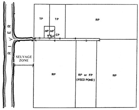
Figure 1. Example of a conventional pond system
(After Alcantara, 1982)
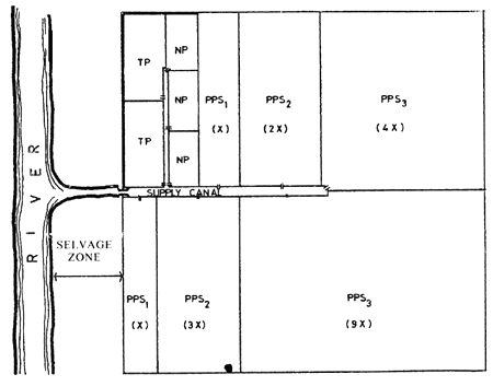
Figure 2. Example of a modular pond system
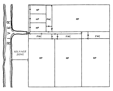
Figure 3. Example of a multiple stock harvest pond system
Figure 4. Example of a radiating type of pond system
(After Djajadiredja and Daulay, 1982)
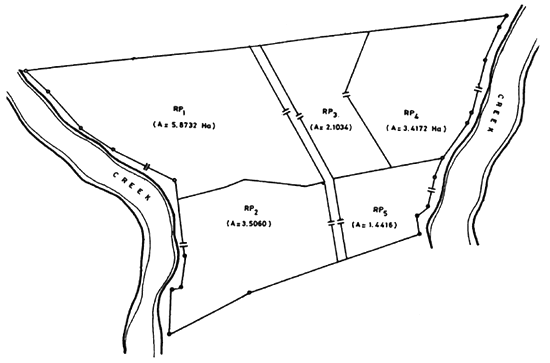
Figure 5. Existing fishpond layout for extensive monoculture of bangos
Figure 5a. Proposed layout for the semi-intensive culture method of shrimp
Figure 6. Existing fishpond layout for an extensive shrimp monoculture
Figure 6a. Proposed layout for shrimp monoculture
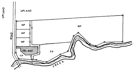
Figure 7. Existing bangos pond layout
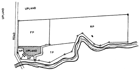
Figure 7a. Proposed pond layout. (Modified modular pond system)
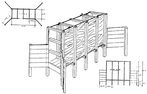
Figure 8. Design of a wooden gate
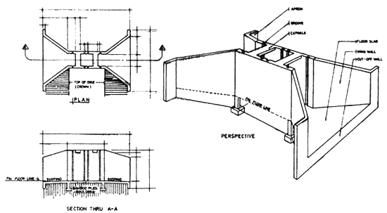
Figure 9. Design of a 1.0 m opening CHB/concrete gate
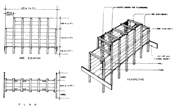
Figure 10. Design of a secondary wooden gate
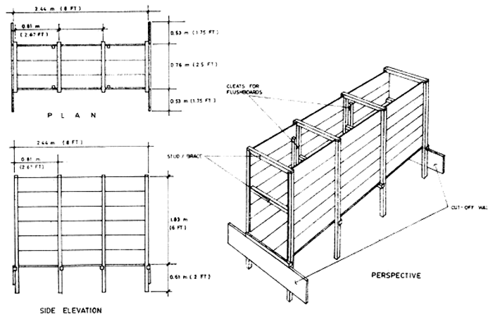
Figure 11. Design of a tertiary wooden gate
by
Apolinar A. Abordo1
ABSTRACT
The procedures and systems employed in designing, layouting and constructing a modified 2½ -hectare pond for shrimp and milkfish are presented. Factors evaluated prior to pond development; vital points considered in site survey; guideline for planning and designing of pond layout; and results expected from pond modification are included. Pond rehabilitation started in June 1985 and work is in progress. The pond is intended to be a model for other fish farmers in the area.
1. BACKGROUND
This paper will report on the procedure and systems made on the planning design, layout and construction in modifying a traditional 2½-hectare brackishwater fishpond for shrimp and milkfish culture. This is a family fishpond located in Bagasbas, a coastal barrio in Daet, Camarines Norte, 4 km away from the municipality. The area is a swampland and was developed into a traditional pond more than twenty years ago. Since construction of the pond was made whenever finances permit, its layout was not properly planned and constructed. This leads to failure in expected output with the result that management and operation became excessively costly and uneconomical.
Reading advances in the technology of aquaculture and the significant improvements made on aquaculture practices, the participant was convinced that traditional ponds were obsolete and improvements and modifications were necessary to make fishpond operation profitable.
Knowing that profitability of aquaculture projects depends on the planning, designing and construction of the fishponds, and subsequently the type of farming system to be carried out, it was decided to try and improve the layout of the family pond.
2. EXPERIENCE
Considering the time, effort, high cost of labor and materials for pond development, proper studies were conducted in evaluating the site to be modified into a fish farm. The following factors were carefully evaluated before investing on fishpond development:
Soil type — Soil samples were taken in the existing ponds and test results were found satisfactory for fishpond construction and species to be cultured.
Elevation and topography — Elevation of land is within reach by ordinary high tide.
Source and adequacy of water supply — The site has an adequate source of water. The ponds can easily be provided with water and drained by tidal energy.
Accessibility and nearness to market and transportation — The site is 4 km away from the Daet market and is accessible through cemented roads by transportation.
Type of vegetation — The pond is cleared of vegetation, but remaining tree stumps in the ponds should be cleared and uprooted.
Availability of fry — Availability of fry for stocking the ponds is abundant in the area.
Climatic and tidal condition of the locality — The area is under Type II Climatic Condition. Tidal fluctuation range is between 1.2 to 1.8 meters which is suitable for both milkfish and shrimp culture.
Susceptibility of area to floods — The pond has never been under water during worse floods experienced in the area.
Availability of ice and electric power — There are iceplants in the municipality, and electrical source can be made available from adjacent fishponds.
Availability of skilled labor — Skilled labor is available in the area but it is preferred to hire labor from some far areas.
Peace and order in the locaity — People in the area are normally peaceful.
After considering the above-mentioned factors, and the site has been decided to be improved and modified, a more detailed survey of the site was conducted. During the survey the vital points considered and verified were:
Establishing and pinpointing the property boundaries.
Checking lot plan measurements and orientations.
Measurement of existing pond areas; length, height and width of dikes; location, number and sizes of gate structures.
Checking elevation of pond bottom, dike height and gate structure from zero tidal datum.
Checking tide fluctuations range in relation to the main gate.
Superimposing actual layout of existing ponds on the lot plans (Figure 1) for reference in modifying the existing ponds.
After undertaking the above-mentioned specifications, guidelines were made for planning and designing of pond layout as follows:
Economic considerations
Main control gate — existing main concrete gate shall be used for the supply and control of water to all ponds to save on construction of new gate.
Secondary gates — wooden gates shall be used for all inlet and outlet gates. (Figure 2).
Dikes — use of existing dike as much as possible in planning of pond layout.
Species to be cultured
Design a fishpond layout for milkfish and shrimp culture.
Milkfish pond shall be designed for modular system of culture.
Shrimp pond shall be designed for two stage progression system of culture.
Water management
Provide supply and drainage canal system for filling and draining of water of ponds.
Provide two sets of wooden gates for each rearing pond for flow-through water system operation.
Maximum height of water at rearing ponds shall be 1.00 m and at nursery ponds at 0.60 m.
Rearing ponds shall be less than 0.5 hectare in area.
Rearing ponds should be laid out with its longer axis on the SE-NW direction.
With all the factors, surveys and guidelines considered and evaluated, planning and designing of the pond modification was made and proposed layout was superimposed on existing layout as shown on Figure 3 to maximize use of existing dikes and minimize construction cost. Based on the modified layout plan as shown on Figure 4 construction of the pond started last June 1985 and was still in progress in October 1985.
In the construction of ponds intensive manual labor is being employed. The work programme is to complete the milkfish ponds and then the shrimp ponds. The work was divided into groups as follows:
Uprooting and clearing of tree stumps.
Construction of new dikes.
Trimming of existing dikes and excavation and levelling of pond bottom.
Fabrication and construction of wooden gates.
Labor on items 1 and 2 were on contractual basis while items 3 and 4 were on daily basis.
The results obtained on the modifications and improvements of the ponds were as follows:
Control of water in individual ponds is easily manipulated resulting in efficient water management.
Control of predators was maximized.
Growth and production of fish has improved.
The construction of the pond becomes a pilot project in the community in development of fishponds.
The formulation of the design and layout of the ponds was an eye opener for other fishpond owners to follow to adapt to modern technology of aquaculture.
Fishpond owners in the area started in clearing their areas of tree stumps and made improvements on their dike and pond construction.
Fishpond owners become interested on new developments of aquaculture practices.
3. FUTURE PLANS AND RECOMMENDATIONS
Future plans are to make the pond the model for aquaculture operation and management in the area to show to the other fishpond owners that fish farming can be a profitable project. This is to justify that improvements were necessary to make operations profitable.
Recommendations are to introduce and assist other fish farmers the methods of intensive brackishwater culturing operations such as:
The improvement of pond design and layout and method of construction
The application of both organic and inorganic fertilizers
The use of pesticides for pest elimination
The method of stocking milkfish and shrimp fry
Proper pond management to increase yields
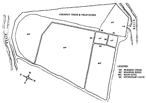
Figure 1. Existing pond layout
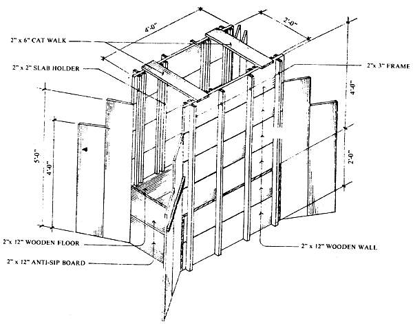
Figure 2. Secondary wooden gate
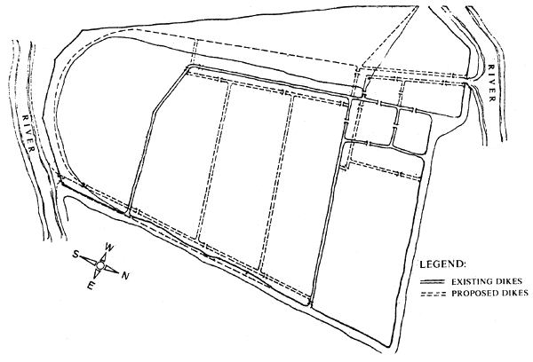
Figure 3. Modified layout superimposed on existing pond layout
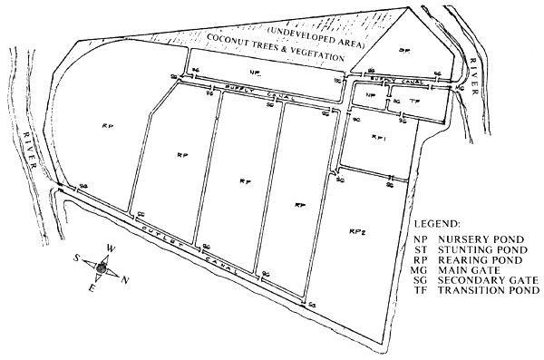
Figure 4. Proposed modification and layout
by
Vicente N. Alferez1
ABSTRACT
The Z Fishing Corporation Shrimp Culture Project located in Zamboanga del Sur is one of the projects undertaken by the Inland Resources Development Corporation (IRDC). An area of 2.5 hectares is preferred to be developed as a pilot area for shrimp culture to serve as a training ground for the staff and to verify technology suited for the area for future expansion. The layout and design of pond system though completed in accordance with plans and specifications, was extended due to lack of manpower, conflicting equipment utilization and delay in the transport of materials. In addition, a wooden pumphouse was constructed instead of a concrete structure to reduce cost. Data on layout and design of ZFC shrimp pond system is discussed in detail.
1. BACKGROUND
The Z Fishing Corporation (ZFC) Shrimp Culture Project is one of several projects being undertaken by the Inland Resources Development Corporation (IRDC), a consultancy group engaged in aquaculture planning, development and management.
The Project is located in Barangay Magsaysay and Tupilac in the municipality of R. T. Lim, Zamboanga del Sur, about 120 km northeast of Zamboanga City facing Sibuguey Bay (Figure 1). The Project area is 337 hectares, of which 218 hectares have been cleared and are being used for extensive milkfish-shrimp culture, and the remaining 119 hectares is a logged-over swampland with second-growth trees traversed by the Tupilac and Leong rivers (Figure 2).
In March 1983, IRDC was commissioned by ZFC to undertake a pre-investment study of the whole area for shrimp culture including a hatchery component. For investment purposes, the entire property was divided into three areas: Area I (97 hectares); Area II (22.5 hectares); and Area III (151 hectares), with each area studied separately for its financial viability.
Because of the enormous investment required to get the Project going, it was decided that Area II, being the smallest, be developed first as a pilot area to serve as a training ground for the project staff as well as to fine-tune the technology for future adoption in the two bigger areas.
Engineering plans, designs, and specifications for Area II were prepared and completed by IRDC in 45 days, after which a contract for construction management was entered into by and between IRDC and ZFC. As stipulated in the contract, IRDC assigned a permanent resident engineer to oversee the construction and to ensure that the engineering designs are adhered to. In addition, a senior consultant made monthly visits to the site during the construction period, which was estimated to last six months but which due to a number of factors stretched to 15 months.
2. THE PILOT AREA
2.1 Physical features
The 22.5-ha pilot area is 800 m long and 400 m wide with a general elevation of 1.30 m above MLLW2. It is bounded by Leong River in the north, Tupilac in the west and south, and Sibuguey Bay in the east.
1 Vice-President for Engineering, Inland Resources Development Corporation. Suite III Mercantile Insurance Building, Gen, Luna, Intramuros, Manila. Also Engineer-Consultant to the ADB/OPEC-funded Laguna de Bay Fishpen Development Project, Laguna Lake Development Authority (LLDA), Pasig, Metro Manila, Philippines
2 Mean Lower Low Water of the tide or 0 datum
It is about 2 km from the national highway and is accessible, halfway through an all-weather road used for delivery of logs from the logging area to the logpond and the rest through existing dikes. It can also be reached by motorized banca via Sibuguey Bay and Tupilac River.
Area II is clear of trees except for some big stumps of a mangrove species, Sonneratia caseolaris (pagatpat). It is separated from Area I by Tupilac River and from Area III by Leong River, two tidal rivers with low salinity owing to freshwater springs and surface runoff from Bisagan and Capisan Hills.
Topography is generally flat with an average elevation of 1.30 m above zero datum.
2.2 Hydrology
During a survey conducted in November 1981, a high rainfall month, the salinity of Tupilac Creek ranged from four ppt upstream to 18 ppt at the river mouth. A more recent survey conducted in March 1983, a low rainfall month, showed a 35 ppt salinity at Tupilac regardless of location during rising tide. At lowest tide, measurements upstream showed the salinity to drop down to 30 ppt.
The March 1983 findings, however, may not conform to the normal yearly pattern in view of the long drought starting from mid-1982. It is believed that under normal conditions, Tupilac receives more fresh water than was observed on 1–3 March 1983.
2.3 Soil conditions
Unlike Area III where the soil was observed to be permeated with root material as well as coralline rocks, the soil in Areas I and II is generally clayey. The analysis of soil samples collected at 1.0 m below surface showed that acidity increases with depth, with pH of 4.9–6.2 at the surface; 4.5–5.1, 50 cm below surface; and 3.3, 100 cm below surface. Organic matter content ranged from 3.8 to 8.6 percent (see Table 1).
2.4 Tidal pattern
The Project site, being within Sibuguey Bay, is governed by Davao tides. Using Davao Station as reference point, the BCGS Tide and Current Tables indicate a time correction of +24 minutes for the time of high and low tides and a height correction for low tide.
On 1 March 1983, an eight-hour tide watch was conducted between 0654 and 1430 hours in order to verify the time of highest and lowest tides. The series of observations showed that the high tide time coincided with the tide table prediction while the low tide comes 37 minutes later than the tide table prediction (Figure 3).
The observations also show that the actual range is greater than the predicted range by 10 cm. Thus, when the readings at the Project site were adjusted to the predicted high tide reading, the low water read (-)0.43 m rather than (-)0.33 m.
2.5 Climatic conditions
Although Zamboanga del Sur belongs to a high rainfall area where the wet and dry seasons are not highly pronounced, the ten-year rainfall data collected at Camp Malubal of the Zambo Wood Products, Inc. show that the months of December to April are generally drier than the rest of the year.
3. BASIC TECHNICAL CONSIDERATIONS
3.1 Area utilization
The predominantly clay-loam soil and the availability of low-salinity from Tupilac Creek makes Area II suitable for giant tiger shrimp or sugpo culture. The development approach recommended for Area II is to utilize it for semi-intensive shrimp culture. Based on the salinity pattern of Tupilac Creek, it shall be possible to have two four-month crops per year when salinity is favorable.
3.2 Pond development
With the culture system determined for Unit II, the physical development was planned for semi-intensive shrimp culture with smaller ponds of one to two hectares, each equipped with separate supply and drainage gates. Since feeding would be necessary, water change by pure tidal action would no longer be sufficient, making the installation of pumps necessary.
3.3 Operational approach
Shrimps shall be stocked at 30 000 juveniles per hectare. PL 30 juveniles are envisioned to attain 33-g size (30 pcs/k) in 120 days. With adequate pond preparation and the application of appropriate management techniques, a survival rate of 70 percent is projected for an equivalent yield of 600 kg of shrimp/ha/crop.
4. ENGINEERING ASPECTS
4.1 Basic considerations
The rearing facilities were designed taking into account the biological and technical requirements for sugpo culture. Basic engineering design considerations were then used to meet these requirements (Table 2). The overall layout was aimed at minimizing movements within the culture area by providing for a smooth and systematic flow of culture materials. Prevailing wind directions were also considered to prevent erosion of dikes. Construction materials were then selected on the basis of compatibility with the culture system, durability, availability and economy.
4.2 Pond layout of pilot area
Based on observations that the sugpo tend to flock along the sides of ponds, the shrimp ponds were designed to be narrow and rectangular in order to increase the perimeter-to-surface area ratio. The narrow configuration was also aimed at simplifying the distribution of pond inputs such as lime, fertilizers, and feeds. A uniform width for all ponds was adopted for convenience in harvesting.
Three layouts were considered for the pilot area. In Scheme A (Figure 4), the 22.55-hectare area was subdivided into 50-meter wide ponds along the north-south axis; and in Scheme B, along the east-west axis (Figure 5). The former meant more (11 units) but shorter ponds; the latter, lesser (7 units) but longer ponds. Although Scheme B has a lesser number of ponds than Scheme A, its orientation is likely to induce wave action of the pond water. In addition, Scheme B has an average pond length of 443 m compared to 279 m for Scheme A.
Although it was stated earlier that an elongated configuration is desirable, the ponds in both Schemes A and B were thought to be excessively long. A third scheme, Scheme C, was therefore adopted (Figure 6). This involved an east-west configuration as in Scheme B but with a central supply canal cutting across the elongated ponds. Side drainage canals were then provided.
As shown in Table 3. Scheme C gave a better percentage of utilization of 77.86 percent as compared to Schemes A and B. Furthermore, a pond length of 130 m was considered manageable from the engineering standpoint because longer ponds would tend to make differential elevations between pond inlet and outlet ends excessive.
Supply water was to be pumped from the Tupilac River as shown in Figure 6. The western half of the area drains into Leong River and the eastern half into the mouth of Tupilac River.
4.3 Ponds and dikes
The design of the ponds and dikes took into consideration the plan to utilize both manual and machine construction. From the pond layout, a trial and error method was adopted to determine the approximate pond elevation so that materials excavated from the pond would be just enough to make the various dike embankments. It was determined that a 30-m deep excavation would be sufficient. For the type of soil obtaining in the area and the method of construction envisioned, a slope of 1:1 was adopted for all types of dikes.
Since the 1983 BCGS Tide Table predicted the highest tide at EL 2.00 m above MLLW, it was decided to set the crown elevation of the perimeter dike at EL 3.00 m with a 1.00 m free-board (Figure 7). Likewise, the supply and drainage crown elevations were set at 3.00 m (Figure 8). The partition dikes were designed to hold one meter of water with a 20 cm free-board (Figure 9). Thus, the crown elevation was set at EL 2.20 m. At this height, the pond bottom shall have an average elevation of EL 1.00 m.
4.4 Supply and drainage canals
The supply canal was designed to serve not only as conveyor of water from the river but also as a settling pond and reservoir. In effect, the supply canal is filled with water at all times with a surface elevation higher than the pond water to induce gravity flow when needed. Pumping is done on a daily basis to replenish the water lost due to evaporation, seepage and regular water management.
The drainage canal was designed to collect water drained simultaneously from all the ponds, as well as absorb excess water from the ponds during heavy downpour and to prevent overflowing of dikes even during high tide.
4.5 Supply and drainage gates
The abundance of timber in the area was the deciding factor in choosing wooden gates instead of masonry or concrete. “Dungon”, the Philippine ironwood, was the main material for supply and drainage gates (Figure 10). Apitong and red lauan were used mainly for gate screen framework and flushboards.
Both supply and drainage gates were of the same design, except for gate flooring elevations upon installation. The opening for the supply and drainage gates was set at one meter with an average discharge of 0.64 m3/sec and 0.80 m3/sec, respectively, capable of filling the pond in five hours and draining in four hours.
The design of the main supply gate was integrated into the design of the pumping station as will be discussed in the next section.
4.6 Pumping station
Although the Zamboanga Peninsula is fortunate to have a tidal range of more than 2.00 meters, the general elevation in the pilot area was observed to be 1.30 m. To be able to maintain a depth of 1.00 m in the ponds throughout the growing period, it was decided to supply the water by pumping from the Tupilac River. The design of the pump was based on an eight-hour pumping to meet the average 6.5 percent of water change per day including losses due to evaporation and seepage.
Towards this end, two units of 3 500 gpm vertical lift, axial flow pumps were chose. Since power is not available at the site, the pumps were coupled to diesel-driven engines.
The pumphouse was designed to accommodate the two pumps arranged in parallel (Figure 11 and 12). Both discharged into a catchmen structure where the water passes through series of screens before flowing into the supply canal. To prevent erosion at the toe of the structure, a curtain wall was also provided Pumping station elevations are found Table 2.
5. POND CONSTRUCTION
5.1 Construction scheme
A combination of manual and mechanic methods were employed in pond development. Since Unit II used to be an undeveloped man- grove forest, the ground was intermittently flooded and drained with the rise and fall of the tide. This being the case, the ground was always waterlogged and therefore incapable of supporting heavy machineries.
Work on the area was divided into two phases. Phase I — the eastern half, and Phase II — the western half. The whole area, however, was first enclosed with perimeter dike using bar mounted mudslingers. A temporary construction gate was installed and the enclosed a completely drained. Once drained, man clearing and grubbing was done with the large stumps left for the bulldozers to pull. In the meantime, the ground was allowed to dry before the bulldozers were deployed.
In order to monitor the progress of work, the dikes were subdivided into stations, each 20-m long. The dike lines were surveyed a laid out first and dike batterboards install in each station to serve as guides in construction.
5.2 Project activities
The project activities were planned and prepared with the end in view of being able to seed the ponds progressively as they are completed. There were activities, however, which simply could not be done on a progressive basis without affecting the overall program of work. An example is the perimeter dike which should be completed first before all other major structures/components are started. Another is benchmark preparation and pond layouting in the field.
There were five major activities undertaken, namely: earthworks, gate fabrication, gate installation and pumphouse construction. Table 4 shows these major activities and their sub-activities together with the quantities of work involved.
5.3 Manpower and equipment utilization
Two large-mounted clam-shells (mudslingers) were employed to build the first stage of the perimeter dike. This was done in three shifts. As soon as the clam-shells had built up a sizeable length, a number of 5 to 7-man teams of dike workers completed the perimeter dike true to form and size. The same method was employed in the construction of the drainage canal dikes. Manual construction was employed. for the partition dikes and the supply canal dikes.
One LGP D5 bulldozer was utilized in the pond levelling after the partition dikes have been formed. In some instances, due to the presence of big pagatpat tree stumps which could not be removed by dozing, dynamite blasting had to be resorted to. About 255 sticks of dynamite had to be used to uproot 15 tree stumps.
The uprooted stumps were cut into small pieces using chain saws and then hauled manually outside the ponds with the aid of flat boxes constructed for the purpose.
In an attempt to field the optimum construction manpower requirements recommended by the consultants and therefore complete the project as projected, the project had to recruit dike workers from as far as Iloilo and Lanao del Norte. Very few manual laborers were available in the project area on account of the “gold rush” or the exodus of people to the mountains in search for gold. In addition, the few people available in the area had very high asking prices.
5.4 Revised project cost
Because of the problems encountered during the early states of project implementation, ZFC management, upon the recommendation of IRDC, approved a revised project cost taking into consideration the needed upgrading of wages as well as administrative support.
From the original cost estimate of  1.68 M
for pond development, the costing was revised
to 2.59 M. This included among other things,
an increase in wages of workers and unit prices
of piece work and escalation cost of equipment
and construction materials.
1.68 M
for pond development, the costing was revised
to 2.59 M. This included among other things,
an increase in wages of workers and unit prices
of piece work and escalation cost of equipment
and construction materials.
6. SUMMARY AND CONCLUSIONS
The project was not without problems. The projected construction duration of six months was protracted to 15 months basically due to lack of manpower supply; conflicting equipment utilization between the mother company logging operations and pond construction operation; erratic delivery of dungon and other materials and lack of transport facilities in bringing the gate materials to the job site.
Inspite of all these, the project was completed in accordance with the plans and specifications except for the pumping station. Instead of a concrete structure, a wooden pumphouse was constructed using dungon wood. The change was made at the request of management in the hope of being able to reduce the cost of construction. Other activities such as the surfacing of the perimeter dike were held in abeyance until projected production could be attained.
Table 1. Results of soil analysis, Units I and II
| Station No. | Depth | Texture | pH | Organic matter (%) | P (ppm) | K (ppm) |
|---|---|---|---|---|---|---|
| 1 | Surface | Heavy | 5.1 | 3.9 | 14 | 1 608 |
| 50 cm | Heavy | 4.4 | 8.4 | 3 | 1 608 | |
| 2 | Surface | Heavy | 4.9 | 8.6 | 10 | 1 848 |
| 50 cm | Heavy | 4.8 | 8.0 | 4 | 1 848 | |
| 3 | 50 cm | Heavy | 4.4 | 8.6 | 3 | 1 616 |
| 100 cm | Medium | 3.3 | 8.2 | 2 | 1 616 | |
| 4 | Surface | Heavy | 5.5 | 3.8 | 10 | 1 800 |
| 50 cm | Heavy | 4.9 | 8.6 | 6 | 1 792 | |
| 5 | Surface | Heavy | 6.2 | 4.0 | 10 | 1 548 |
| 50 cm | Heavy | 5.1 | 8.6 | 6 | 1 872 |
* Notes on soil texture: Heavy = clay-loam
Medium = sandy-clay
Table 2. Basic engineering design considerations
| 1. | Tide elevation (Datum: MLLW) | ||
| a) | Highest tide level | : EL 2.00 | |
| b) | Lowest tide level | : EL 0.50 | |
| 2. | Ground elevation (Datum: MLLW) | ||
| a) | Seaside (Eastern boundary) | : 1.50 to 1.80 | |
| b) | Riverside (Western and southern boundaries) | : 1.30 | |
| c) | Interior of pilot area | : 1.30 (Ave.) | |
| 3. | Soil characteristics | ||
| a) | Soil texture | ||
| Surface to 100 cm deep | : clay-loam | ||
| 100 cm below | : Sandy-clay | ||
| b) | Sweel | : 30% | |
| c) | Shrinkage | : 10% | |
| d) | Consolidation | : 30% after 6 to 12 mos. | |
| 4. | Construction material | ||
| a) | Dikes | : Clay-loam, sandy-clay | |
| b) | Gates | : Wood (dungon or other water-resistant lumber) | |
| c) | Pump station | : Concrete-timber | |
| 5. | Design criteria | ||
| a) | Main drainage canal | ||
| Discharge | : 4 m3/sec | ||
| Slope | : 0.075% | ||
| n | : 0.026 | ||
| b) | Main supply canal | ||
| Discharge | : 4 m3/sec | ||
| Slope | : 0.075% | ||
| n | : 0.026 | ||
| c) | Pond | ||
| Total drain time | : 4 hours | ||
| Filling time | : 5 hours | ||
| 6. | Design elevations | ||
| a) | Top of perimeter dike | : ELEV. 3.00 | |
| b) | Top of partition dike | : ELEV. 2.20 | |
| c) | Top of supply canal dike | : ELEV. 3.00 | |
| d) | Top of drain canal dike | : ELEV. 3.00 | |
| e) | Pump discharge | : ELEV. 2.55 | |
| f) | Pond bottom (ave.) | : ELEV. 1.00 | |
| g) | Drainage canal bottom | : ELEV. 0.00 at Southern of eastern canal, ELEV. 0.40 at northern end of eastern drainage canal. | |
| h) | Supply canal bottom | : ELEV. 0.90 at northern and southern end. sloping towards main supply canal at ELEV. 0.50 | |
| i) | Supply gate floor | : ELEV. 1.00 | |
| j) | Drain gate floor | : ELEV. 0.80 | |
| 7. | Design frequency of water change | ||
| a) | First two weeks | : 1% per day | |
| b) | Next 6.5 weeks | : 5% per day | |
| c) | Next 3.5 weeks | : 7.5% per day | |
| d) | Last 2 weeks | : 15% per day | |
| e) | Average | : 6.5% per day | |
Table 3. Comparative analysis of different development schemes for Unit II area
| UNIT II | |||
|---|---|---|---|
| A | B | C | |
| Gross area (ha) | 22.55 | 22.5 | 23.63 |
| Net area (ha) | 17.00 | 17.03 | 18.40 |
| Utilization (%) | 75.54 | 75.55 | 77.86 |
| Canals | |||
Supply | 0.35 | 0.35 | 0.40 |
Drain | 0.00 | 0.00 | 0.69 |
| Drain | |||
Perimeter | 4.17 | 4.17 | 2.85 |
Canal | 0.36 | 0.27 | 0.60 |
Partition | 0.85 | 0.73 | 0.69 |
| Number of rearing ponds | 11 | 7 | 18 |
| Average size of rearing ponds (ha) | 1.54 | 2.43 | 1.156 |
| Average length of rearing ponds (m) | 279 | 443 | 130 |
Table 4. Project activities and quantities of work
| Activity | Volume of work | ||
|---|---|---|---|
| A. | EARTHWORKS | ||
| 1. | Clearing and layouting (ha) | 16.301 | |
| 2. | Uprooting (ha) | 25.38 | |
| 3. | Dike construction (cu m) | ||
Perimeter dike | 27 993.00 | ||
Partition dike | 9 603.30 | ||
Supply dike* | 19 569.00 | ||
Drainage dike* | 7 395.00 | ||
| 4. | Pond levelling (ha) | 17.00 | |
| 5. | Dike surfacing (cu m), perimeter | 832.92 | |
| 6. | Riprapping of seaside dike (cu m) | 2 384.25 | |
| B. | GATE FABRICATION (BF) | ||
| 1. | Sawing, cutting, and fitting | 49 184 | |
| C. | GATE INSTALLATION (UNITS) | ||
| 1. | SG-1 | 16 | |
| 2. | SG-2 | 2 | |
| 3. | DG-1 | 16 | |
| 4. | DG-2 | 2 | |
| 5. | MDG-1 | 2 | |
| D. | PUMPHOUSE (UNITS) | 1 | |
* Other component of these activities was canal excavation.
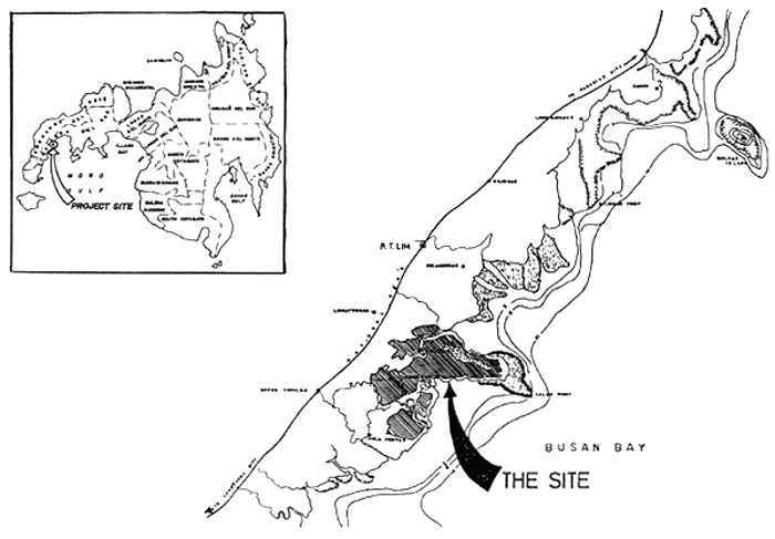
Figure 1. Map showing the location of the project
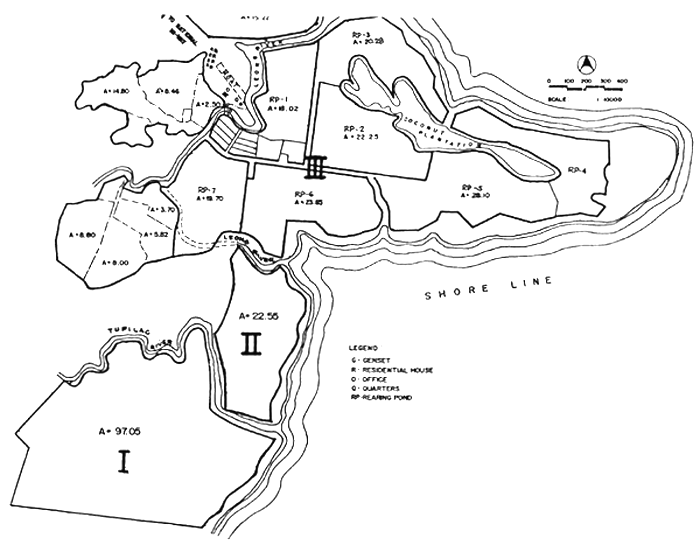
Figure 2. The project site
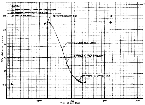
Figure 3. Tide profile at Leong River, 1 March 1983
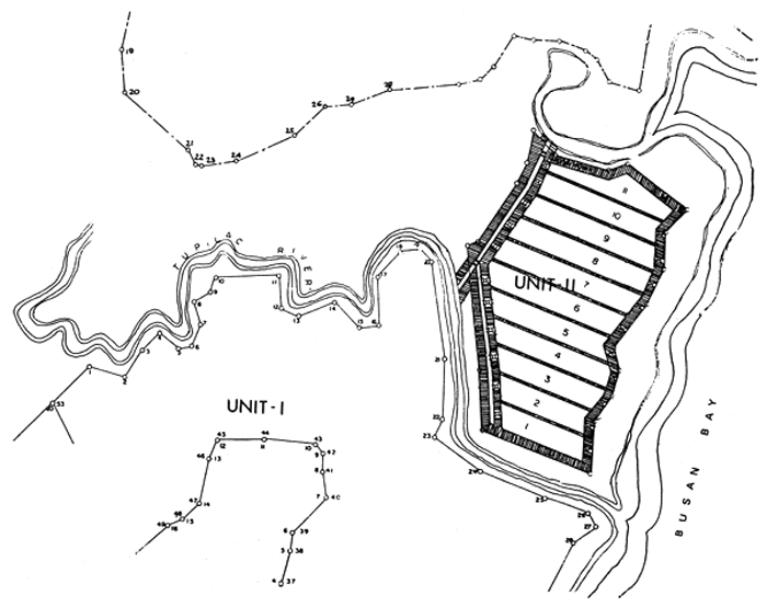
Figure 4. Development Scheme A, Unit II
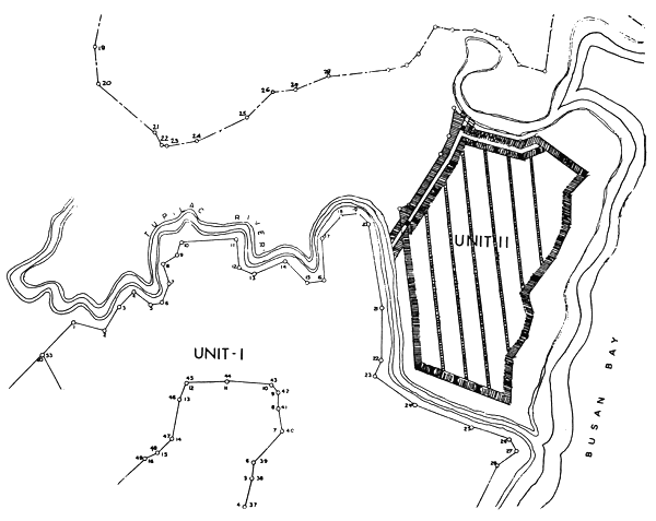
Figure 5. Development Scheme B, Unit II
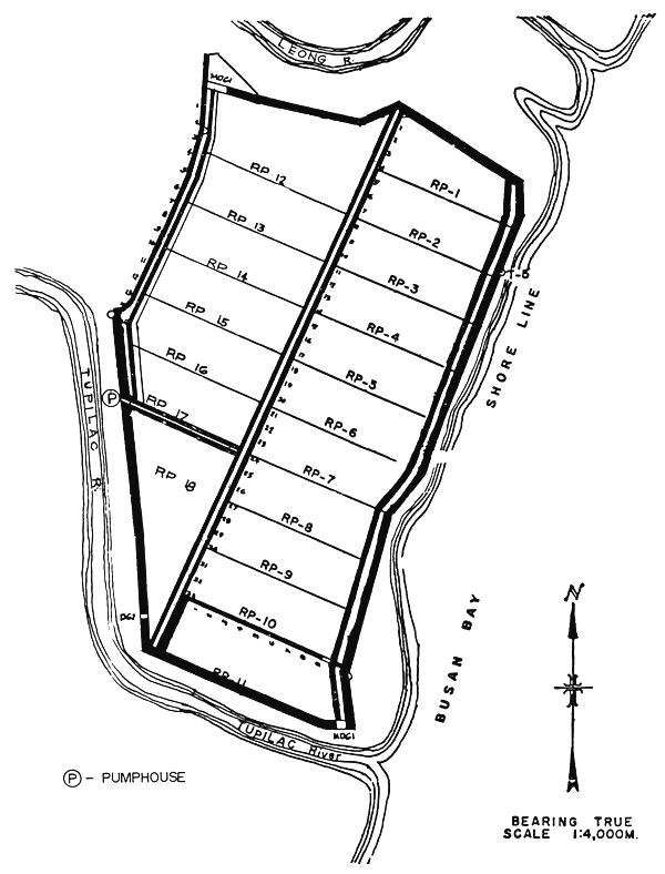
Figure 6. Pond layout (Scheme C)
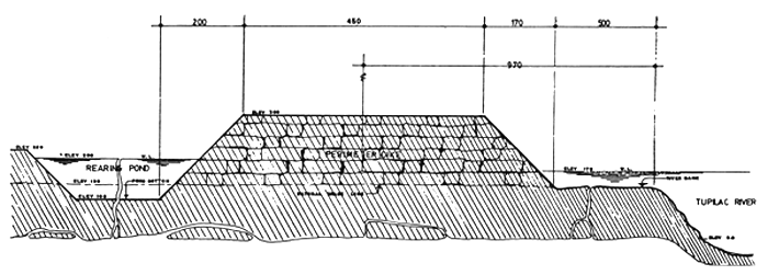
Figure 7. Typical section of perimeter dike
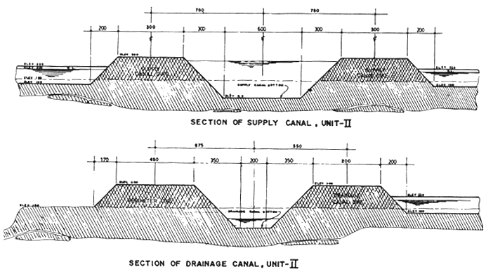
Figure 8. Sections of supply and drainage canals, Unit II
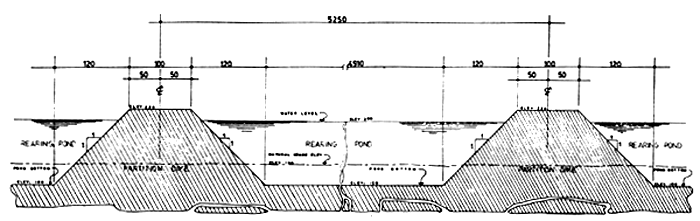
Figure 9. Typical section of a partition dike
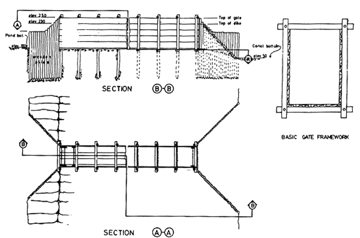
Figure 10. Schematic diagram of typical supply and drainage wooden gates for the rearing ponds
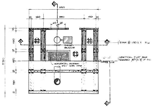
Figure 11. Plan view of pumphouse
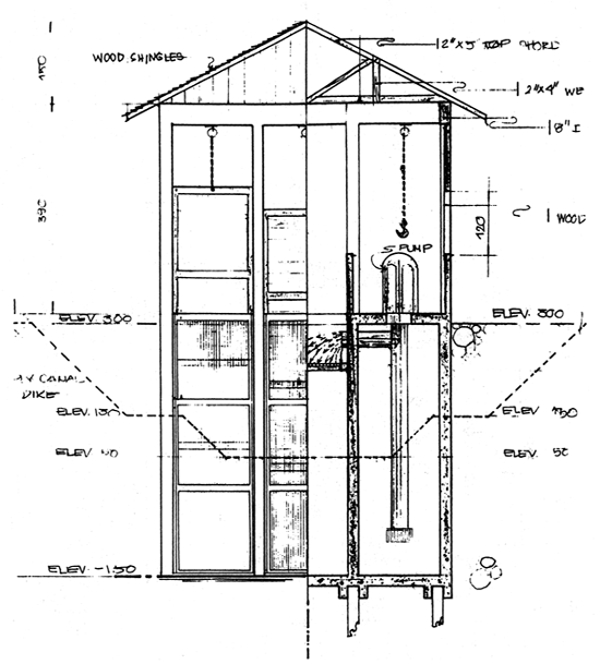
Figure 12. Section of pumphouse
by
Orlando K. Yu1
ABSTRACT
Various floating cage and fishpen designs are employed to meet enclosure requirements of shrimp and milkfish brood-stock, and for rearing of other finfish at the lgang Substation of the SEAFDEC Aquaculture Department in Nueva Valencia, Guimaras Island. In addition, support facilities are constructed like pontoon catwalks, wet laboratory, pumphouse, power house and researchers' quarters. With the establishment of the Department's Naujan Substation in Mindoro in 1978, floating cages and transport cages are also designed and installed. Following encouraging results of milkfish broodstock studies leading to natural spawning, rematuration and re-occurrence of natural spawning and completion of the milkfish life cycle, a development plan for the lgang Substation was prepared for full development of the Substation as a mariculture center. Specific recommendations towards this end are presented.
1. BACKGROUND
The Igang Substation
Conceived as a mariculture center, the SEAFDEC/AQD Igang Substation was established in 1974. The set-up was initiated by one of AQD's pioneering researchers. The following studies are being conducted at Igang:
Rematuration of Penaeus monodon (known as jumbo tiger shrimp);
Rearing of P. monodon fry; and
Further rearing of pond-grown milkfish (marketable size) for broodstock development.
Culture enclosures designed at Igang were fishpens and make-shift floating cages. The enclosures were constructed/laid out at Humaraon Cove near the substation house which is located on an islet.
2. EXPERIENCES
2.1 Work at Naujan Substation
In 1978, the Department established the Naujan Substation in Oriental Mindoro province to study maturing milkfish (sabalo) migrating from Naujan Lake to Lumangbayan sand dunes through the meandering Naujan River. The fabrication of floating cages consisting of 3 units 12.0 m diameter × 6.0 m deep was initiated. These were towed and moored at Buloc Cove where they were installed. The following materials were utilized for this work:
Frame: 2-inch diameter G.I. pipe, sch. 40 coated with glass flakes after fabrication
Net enclosures: nylon nets, 210 d/40, 3-inch mesh size
Net reinforcement: ½-inch diameter polythelene rope
Net reinforcement ties: nylon twines, 210 d/40
Anchor rope: 1-inch diameter polythelene rope
Anchors: pre-cast concrete block
Floats: 0.6 m diameter × 1.0 m (9 floats per cage)
Sinker: pre-cast concrete with preembedded copper wires
Migrating maturing milkfish caught (by concessionaire) inside a fish trap were observed to be jumping, causing injury to the fish. Three heads of maturing milkfish were transported from the fish trap (via Naujan River) to Buloc Bay using a box-type transport cage made of knotless synthetic net with PVC pipe frames. The cage was attached to the boat's outriggers using bamboo poles, the route being a meandering river with narrow widths. The desired uniform boat speed that will keep pace with the fish could not be attained, thus the maturing milkfish would often bruise themselves against the walls of the transport cage. The fish survived the trip to Buloc Bay where they were transferred to one of the floating cages, only to die a few days later.
2.2 Using Naujan experience for Igang
For the Igang Substation, the fabrication/ towing/mooring of floating cages with similar design to that fabricated in the Naujan Substation was endorsed in 1977/1979, with the following specifications:
Two units: 10.0 m with diameter × 6.0 m deep
Two units: 9.0 m diameter × 6.0 m deep
Two units: 6.0 m diameter × 6.0 m deep
The depth of these cages was later changed from 6.0 m to 3.0 m as a result of site relocation.
The primary purpose of initiating the fabrication of these cages was to salvage the few remaining milkfish broodstock (originally about 2 000 heads) which were left to survive at the Humaraon Cove inside stone/boulder enclosures. Before their transfer to the floating cages, the fish looked thin then and their heads were noticeably big. Approximately 734 heads were transferred and within a month's time after feeding them with pelletized commercial feeds in floating cages they regained their health. In 1980, a few of these salvaged milk-fish broodstock spawned naturally, which was a breakthrough in the natural spawning of milkfish in captivity.
2.3 Igang development plan and other recent activities
In early January 1983, improvements needed in the Igang Substation was discussed. A development plan of Igang as a mariculture center was prepared. Experience was further gained in implementing and overseeing the construction of the following new facilities:
Wet laboratory (697 m2)
Station head residence/guest house
Researcher's quarters
Wooden pontoon/catwalk
Wooden pumphouse
Power house
Fishpens
2 units: 20.0 m × 30.0 m
1 unit: 10.0 m × 10.0 m
2 units: 20.0 m × 20.0 m
Floating cages with wooden frames
6 units: 6.0 m diameter
4 units: 10.0 m diameter
3. PLANS AND RECOMMENDATIONS
3.1 The wooden (yacal) posts of the catwalks and pumphouse are infested with marine borers and should be replaced with reinforced concrete as originally designed.
3.2 The pontoon main member frames should be changed to rigid steel members and thoroughly coated with anti-corrosive paints (epoxy). As a consequence of pontoon design modifications, float requirements must be adjusted accordingly (styrofoam floats) to include hydrographic survey (future culturing areas) with emphasis on determining current velocities and prevailing directions. This station deserves a full time engineer/architect knowledgeable in aquaculture engineering.
3.3 Reset the location of existing floating cages to attain better water exchange. Fouled nets are not often replaced. The biological requirements of the fish should have priority over convenience in feeding and sampling activities.
3.4 Replace all anchors of the floating cages with pile-driven reinforced concrete posts as the hydrography of the site favors such alternative.
3.5 Periodic replacement of fouled synthetic net enclosures require many manhours. This is particularly true in broodstock cages. The issue of the need for anti-fouling net treatment is once again brought out for consideration, although this was discouraged in the 1976 Kyoto Conference.
3.6 Since the periodic replacement activity of net enclosures is one major tedious job, it is strongly recommended that a net enclosure lifting mechanism, manually-operated if possible, be designed and fabricated.
3.7 In general, for better water exchange, the longer side of the floating cage should be set/moored perpendicular to the prevailing current direction. A series of connected floating cages should be discouraged in favor of separate single units.
3.8 For broodstock development, use of rigid frames is advisable preferably individual units.
3.9 The environmental problem of the corrosive action of seawater/see breeze on exposed metals greatly affects installations by and on the sea. This is one area towards which aquaculture engineering research should be directed.
3.10 Since natural spawning of milkfish occurs at night in the floating cages (flow-through net enclosures), the problem of egg collection would always be experienced. Such problem may be solved ultimately, if the fish are made to spawn in land-based flow-through hatchery tanks or in floating hatchery. The latter would cause less stress to the milkfish.
3.11 The conceptual development plan of Igang as a mariculture center has been accomplished, for consideration. The area is a natural fish sanctuary and offers a wide variety of marine species which may become the subject of investigation by researchers in generating more aquaculture technologies.
![]()
![]()
![]()