![]()
![]()
![]()
Balarin, J.D. 1985 National Reviews for Aquaculture in Africa. 7. Kenya. FAO Fish. Circ. (770.7): 96 pp.
Bell, F.W. and E.R. Canterbery 1976 Aquaculture for Developing countries: A Feasibility Study. Cambridge Ballinger Publ. Co., 266 pp. (not seen, but cited by Balarin)
Bhushan, K. 1983 Kenya 82–83 Yearbook, Newspread International, Nairobi. 216 pp.
Dale, I.R. 1939 The Woody Vegetation of the Coast Province of Kenya. Imp. For. Inst. Paper 18: 1–22
Kenya Ports Authority 1986 Tide Tables for East African Ports, 1986
Kenya Soil Survey 1982 Exploratory Soil Map and Agro-Climatic Zone Map of Kenya. Exploratory Soil Survey Report No. El
Kenya Soil Survey 1983 Surface Geology and Soil Map (prepared by Japan International Cooperation Agency), 1st ed.
Kokwaro, J.O. 1984 The Distribution and Economic Importance of the Kenyan mangroves. In: Endangered Resources for Development, Proceedings of a Workshop on the Status and Options for Management of Plant Communities in Kenya, March 1984
Michieka, D.O., B.J.A. van der Pouw and J.J. Vleeshouwer 1978 Soils of the Kwale-Mombasa-Lunga-lunga area. Reconnaissance Soil Survey Report No. R3, Kenya Soil Survey
Nicolic, M. and Y.A. Tang 1976 Proposed Model of a Coastal Fish Farming Pilot Production Project for Kenya. Indian Ocean Fishery Survey and Development Programme INT/71/034. FAO, Rome
Padlan, P.G. 1982 Report on Consultancy, Kenya Brackishwater Aquaculture Project, ADCP/Circ./82, FAO, Rome
Sivalingam, S. 1981 Basic approach to mariculture: problems and development strategies. In: Proceedings KMERI Workshop on Aquatic Resources of Kenya, July 13–19, Mombasa
Wokabi, S.M., W.G. Sombroek and J.P. Mbuvi 1973 A preliminary evaluation of the irrigation suitability of the lands in the pre-delta Tana floodplain (Marembo-Garsen). Site Evaluation Report No. 15, Kenya Soil Survey
Wokabi, S.M. 1976 Preliminary evaluation of the soil conditions of the Tana delta for irrigation development. Site Evaluation Report No. P23, Kenya Soil Survey
| District | Length of coastline (km) |
| Lamu | 650 |
| Tana River | 120 |
| Kilifi | 265 |
| Mombasa* | 175 |
| Kwale | 210 |
| Total length | 1 420 |
* Includes coastline of entire Port Reitz portion of which lies within Kwale District
| District | Area (ha) | Percent |
| Lamu | 28 400 | 56 |
| Tana River | 3 000 | 6 |
| Kilifi | 6 400 | 13 |
| Mombasa* | 3 100 | 6 |
| Kwale | 9 100 | 19 |
| Total Area | 50 400 | 100 |
* Includes the whole of Port Reitz portion of which lies within Kwale District
Table 3
Summary of field observations, Lamu District, Kenya,
10–15 March 1986
| Location | No. of Stations | Elevation (m) | General Description |
| Kimbo | 4 | 2.2 – 2.6 | Rhizophora. Topsoil siltloam, subsoil generally peaty. Clay materials may be found in some spots. Thick forest. |
| Mkunumbi | 4 | 2.8 – 3.2 | Vast, clear tidal flats, after narrow Rhizophora/Avicennia band. Topsoil, sand; subsoil sand to peaty-sand. Avicennia sparse around fringes. |
| Hidio | 6 | 2.8 – 3.2 | (Same as Mkunumbi) |
| Ungu | 5 | 1.9 – 2.6 | Areas with lower elevation covered by Rhizophora, others clear tidal flats. Topsoil from silty loam (Rhizophora area) to sandy (clear flat); subsoil peaty. |
| Kipungani | 4 | 1.2 – 1.4 | Thick Rhizophora cover. Topsoil, silty sand to sand; subsoil peaty sand. |
| Manda Is. | 4 | 0.9 – 2.9 | Thick Rhizophora. Topsoil very loose sand and silt. Subsoil very peaty. |
| Bora Imani | 1 | 3.2 | Clear tidal flat. Same as Mkunumbi. |
| Magogoni | 1 | 3.5 | Clear flat behind sand dune. Topsoil light brown sand. Subsoil with mottles of gray clay and organic matter but still sandy. |
| Wange Creek | 2 | 1.8 – 3.3 | Low areas with thick Rhizophora. High areas, clear sand flats. Substrate sand to peaty sand. |
| Dodori Creek | - | - | (Survey party unable to land at tidal flats due to shallow waters at low tide). Creek bed of soft silty-and sand material. Viewed, from distance through breaks in narrow Rhizophora zone, clear areas behind with characteristic appearance of sand flats fringed by Avicennia typical to all other areas examined). |
| Pate Is. | 2 | 0.9 – 1.2 | North coast; topsoil silty sand, subsoil peaty; West coast frontal by 1.25 km of shallow reef flat, exposed in parts, mangrove areas dominated by Rhizophora substrate sandy to peaty. |
| Rasini | 1 | 1.6 | Thick Rhizophora. Substrate very thin layer of sand over peat material with very little sand, consisting of live roots. |
| Uvondo | 2 | 1.38–3.2 | Low area, Rhizophora forest. High area, clear with sparse Avecennia. Substrate, sand to peaty sand. |
| Kwakate | 1 | 1.56 | Sparse Rhizophora behind sand dune. Substrate sand to peaty sand. |
| Tukutu | 2 | 1.8.2.95 | Low area, thick Rhizophora with soft silty mud substrate. High area characteristic sand flat with peaty subsoil. |
| Mokowe | 2 | 3.5.4.0 | Vast clear tidal flats with sparse Avicennia patches at edges. Topsoil, sand. Subsoil same mottled with dark organic matter, peaty close to vegetation. |
Table 4
Result of Field Survey and Soil Analysis,
Tana River area, Kenya
| S O I L* | ||||
| Station | Nature of Area | Elevation (m) | Type | pH |
| 1 | Mangrove near river mouth | 2.10 | Silty-loam | (no sample taken) |
| 2 | Mangrove | 3.3 | clay | 7.64 |
| 3 | Mangrove | 3.10 | clay | 6.98 |
| 4 | Mangrove | 3.0 | clay | 6.86 |
| 5 | Mangrove | 3.8 | sandy clay | 6.55 |
| 6 | Seasonal swamp | 4.0–4.3 | sandy clay | 6.10 |
| Name of Company | Area occupied (ha) | |
| Tana saltworks a | 380 | |
| Kurawa saltworks | 800 | |
| (Name unknown) b | 1 300 | |
| Kristalline | 1 200 | |
| Malindi Saltworks | 664 | |
| Kensalt Saltworks | 2 264 | |
| Fundisa Saltworks | 1 018 | |
| Ngomeni Saltworks | 296 | |
| Total | 7 922 | |
a abandoned but proposed for rehabilitation
b area already surveyed and claimed
Table 6
Result of Field Survey and Soil Analysis,
Ngomeni to Kurawa area, Kenya
| SOIL* | |||||
| Location | Nature of area | Elevation (m) | Type | pH | |
| Ngomeni | a) Clear | 2.87 | Sandy loam | 7.46 | |
| b) Mangrove | 2.76 | Clay loam | |||
| c) Mangrove | 3.00 | Sandy clay loam | 7.25 | ||
| Fundisa | Open flat | 3.50–4.0 | Sandy clay loam | 7.17 | |
| Kensalt | a) Open flat, topsoil | 3.50–4.0 | Silt loam | 7.86 | |
| subsoil | clay loam | 6.95 | |||
| b) Mangrove, topsoil | 2.80 | Silty clay loam | 7.43 | ||
| subsoil | Clay loam | 7.25 | |||
| Kurawa | a) Mangrove | 2.50 | Sandy clay loam | 6.93 | |
| b) Open flat | 3.50–4.0 | Clay loam | 6.04 | ||
| Kristall | Open flat | 3.50–4.0 | Sandy clay | 6.80 | |
| Tana saltworks | Open flat | 3.0 – 4.0 | Sandy clay loam | 6.96 | |
Table 7
Result of Field Survey and Soil Analysis,
Port Reitz and Port Tudor, Mombasa, Kenya
| SOIL* | |||||
| Station | Nature of Area | Elevation (m) | Type | pH | |
| Port Reitz | 1. Clear Area | 3.93 | Sandy clay loam | 5.67 | |
| 2. Mangrove (topsoil) | 2.25 | Silty clay loam | 6.97 | ||
| (subsoil) | Loam | 6.78 | |||
| 3. Mangrove | 3.32 | Silty clay loam | 7.43 | ||
| Port Tudor | 1. Mangrove | 1.75–1.85 | (silty-loam to peaty, n.s.) | ||
| 2. Mangrove | 1.85 | Loam | 6.80 | ||
| 3. Mangrove | 1.85 | Sandy loam | 6.97 | ||
| 4. Mangrove | 1.85 | (soft, silty mud, n.s.) | |||
| 5. Mangrove | 1.85 | Loam | 6.93 | ||
| Location | No. of Stations | Elevation (m) | General Description |
| Bodo | 3 | 2.0–3.2 | Low area with Rhizophora. Top soil sand. Subsoil mottled with clay. High areas, clear flat with some Avicennia. Topsoil sand. Subsoil peaty sand. |
| Bodo saltfarm | 1 | 3.8 | Abandoned, approx 5 ha. Developed from clear flat. Bottom of ponds and topsoil: sand. Subsoil. clay at 5 cm. Area outside pond: sand with mottles of clay. |
| Munge | 1 | 3.0 | Clear area; sand to peaty-sand. Rhizophora forest: sand with little clay. |
| Shimoni | 1 | 1.86 | Rhizophora-/Avicennia. Peaty-loam 30 cm deep over coraline bed. |
| Kisiwani | 1 | 2.7 | Rhizophora/Avicennia. Peaty-loam from surface to 50 cm. |
| Marjorine | 1 | 3.1 | Clear tidal flat behind Rhizophora: peaty sand from surface to 35 cm, greyish clay sand below. |
| Jimboni | 1 | 2.2 | Rhizophora stand behind white sand beach. Topsoil, loam sand up to 25 cm. Subsoil, dark peaty loam. |
| Vanga | 3 | 2.0–3.0 | Clay-loam to peaty loam in Rhizophora stand, stand to peaty sand in clear flats. |
| Gazi | 1 | - | Avicennia stand. topsoil sand Subsoil peaty sand. |
Table 9
Summary of Findings: Survey of the Coastal Areas of Kenya
for Shrimp Farm Development
| District | Type of area | Elevation(m) | Soil | Potential for Development |
| Lamu | Mangrove | 0.9–2.0 | Sand/peat | poor |
| tidal flat | 2.8–3.5 | sand/peat | poor | |
| Tana | Mangrove | 3.0–4.0 | clay/sandy | good |
| Kilifi 1 | Mangrove | 2.5–3.8 | sandy-clay loam/silty-clay-loam | occupied |
| tidal flat | 3.5–4.0 | sandy-loam/clay loam | occupied | |
| Mombasa 2 | Mangrove | 1.8–3-2 | silty-clay/clay loam | fair |
| tidal flat | 3.9–4.0 | sandy/sandy loam | poor | |
| Kwale 3 | Mangrove | 1.8–2.8 | sand/peat | poor |
| tidal flat | 3.5–4.0 | samd/peat | poor |
2 Includes the whole of Port Reitz.
3 Shimoni-Vanga and Gazi Bay only.
| Name of Company | Area of reservoir (ha) |
| Tana Saltworks | 60* |
| Kurawa saltworks | 80 |
| (Unknown Company) | 130 |
| Kristalline | 86* |
| Malindi | 75* |
| Kensalt | 226 |
| Fundisa | 102 |
| Ngomeni | 30 |
| Total | 789 |
Table 11
Inventory of Potential Shrimp Culture Areas in Kenya
| Location | Extensive | Intensive | Total (ha) |
| Tana River North Bank | 0 | 1000 | 1000 |
| Bellazoni Estate | 0 | 500 | 500 |
| Ngomeni to Kurawa | |||
| Salt Works Reservoir | (800) a | 800 | |
| Peripheral Mangrove | 0 | 1000 b | 1000 |
| Port Reitz | 150 | 150 | 300 |
| Port Tudor | 350 | 0 | 350 |
| 500 | 2650 | 3150 | |
| (1300) c | (3950) c |
a Refer to first reservoirs of existing and proposed salt farm, See Appendix III for details.
c total including saltworks reservoir.
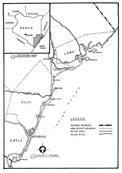
Figure 1. The coastal area of Kenya showing boundaries of administrative districts.
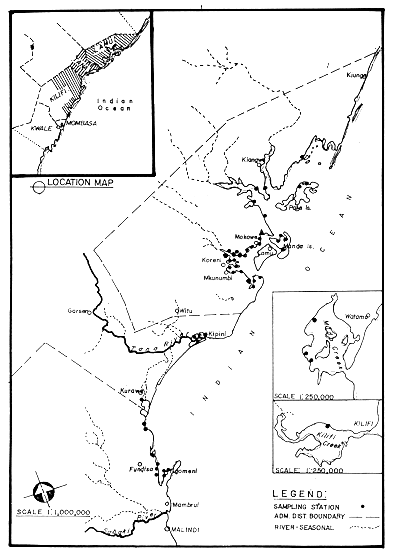
Figure 2. Location of sampling stations at the northern portion of the Kenya coastline from Kilifi Creek to Lamu; Site Survey Mission, Project KEN/80/018.
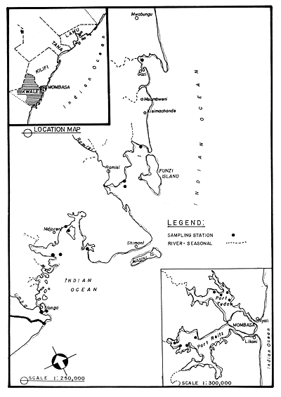
Figure 3. Location of sampling stations at the southern portion of the Kenya coastline from Mombasa to Vanga; Site Survey Mission, Project KEN/80/018.
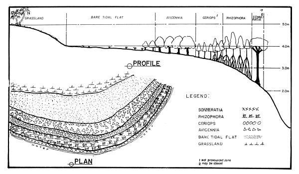
Figure 4. Schematic representation of a typical tidal swamp and flat in the coastal area of Kenya.
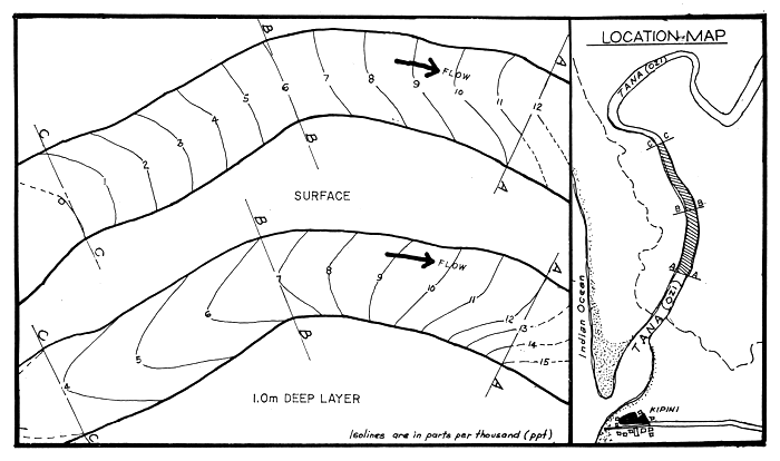
Figure 5. Horizontal salinity distribution, surface and one-meter layer; Tana River, Kenya; 21 March, 1986, 1300 to 1350 hours. (Low: 1.33 m at 0802 hrs. High: 2.09 m at 1408 hrs.)
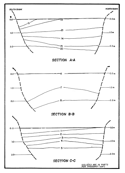
Figure 6. Vertical salinity profiles at three different sections of Tana River, Kenya; 21 March, 1986, 1300 to 1350 hours. (Low: 1.33 m at 0802 hrs. High: 2.09 m at 1408 hrs.)
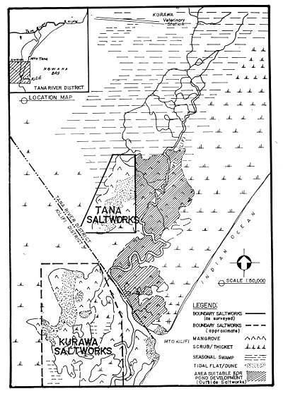
Figure 7. Site of abandoned Tana Saltworks at Mto Kilifi area, Tana River District, being proposed for an integrated saltworks and shrimp farm project.
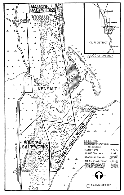
Figure 8. Map of Kurawa to Ngomeni area, Kilifi District, Kenya, showing location of saltworks.(1 of 3)
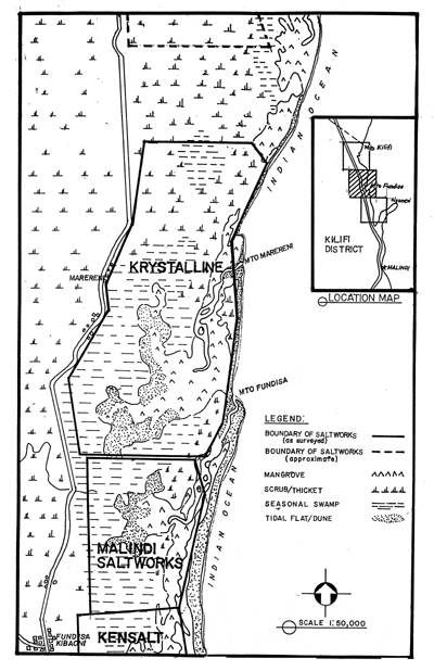
Figure 8. Map of Kurawa to Ngomeni area, Kilifi District, Kenya, showing location of saltworks.(2 of 3)
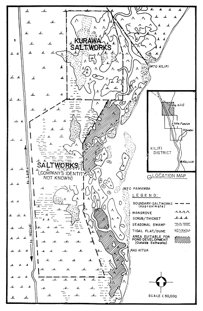
Figure 8. Map of Kurawa to Ngomeni area, Kilifi District, Kenya, showing location of saltworks.(3 of 3)
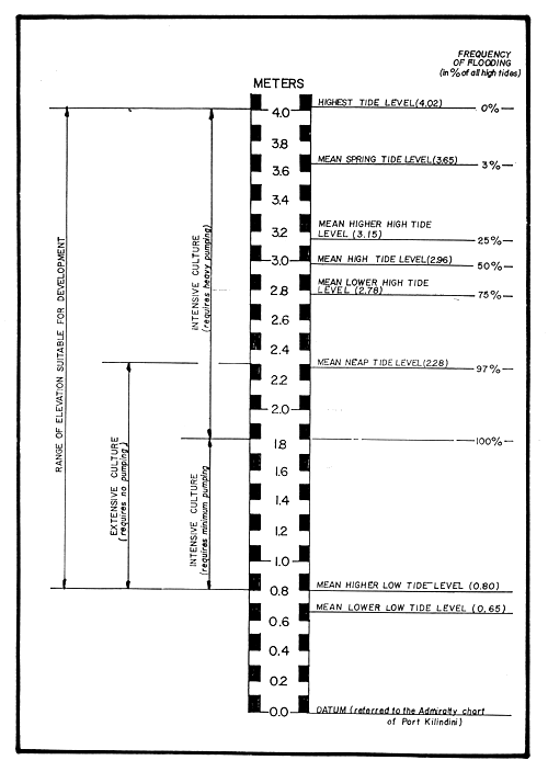
Figure 9. Diagrammatic presentation of the optimal elevation ranges for various shrimp culture systems based upon tidal characteristics of Kenyan waters.
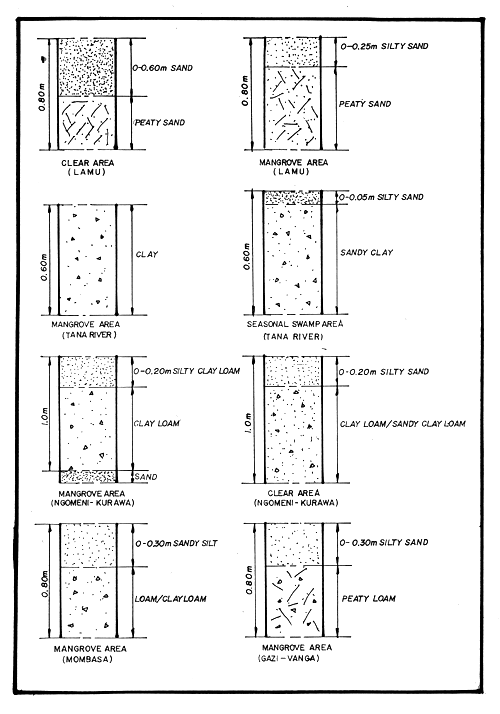
Figure 10. Typical soil profiles at various sites along the coastal area of Kenya.
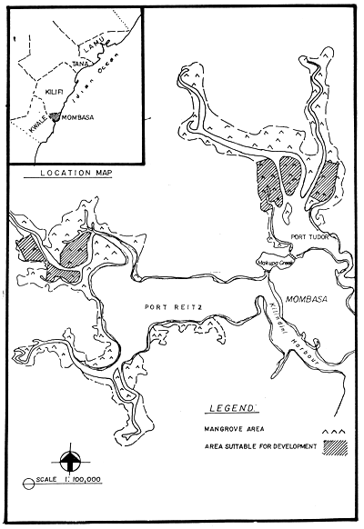
Figure 11. Tidal swamps within Mombasa showing sites with potential for shrimp farm development.
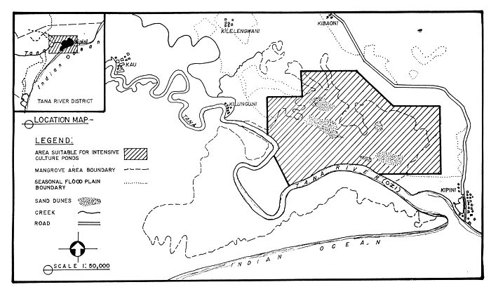
Figure 12. Tidal swamp area along the Tana River bank showing site deemed suitable for semi-intensive or intensive culture of Penaeus monodon.
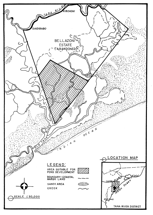
Figure 13. The abandoned Bellazoni estate along the old Tana River showing portion which could be developed for shrimp farming.
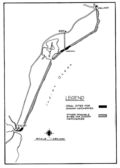
Figure 14. Sites found ideal for shrimp hatchery development and extent of coastline from Kilifi to Malind where other potential sites may be found.
![]()
![]()
![]()