![]()
![]()
![]()
Due to the often strong altitudinal gradients in mountains and accordingly remarkable changes over relatively short distances in meteorological, hydrological (including cryospheric), and ecological conditions (in particular land cover, soil, and related conditions), mountain regions provide unique opportunities for the detection and analysis of environmental change processes (cf. Box 2). This element of the IGBP Mountain Research Initiative will focus on mountain-specific indicators of environmental change, which are sensitive to changes in climate, atmospheric chemistry, radiation, and land use/land cover. Sets of such indicators are defined below that can be used (1) to detect and analyse signals of environmental change, and (2) to study both direct cause-effect relationships in individual systems as well as changes that derive from the complex interactions of different drivers of global change.
|
Box 2. Empirical evidence on the climatic sensitivity of mountain systems. Recently, evidence was provided by re-sampling studies in the central Alps (Grabherr et al. 1994) that species richness has increased at the majority of investigated high summits since the turn of the century, suggesting that the warming recorded since that time has been ecologically relevant (cf. Pauli et al. 1996). Similarly, climate change during this century has significantly affected the cryosphere. For example, glaciers have retreated worldwide (cf. Haeberli 1995), and the temperature of the permafrost layer in the European Alps now appears to change remarkably (Haeberli & Beniston 1998, Vonder Mühll et al. 1998). Mountains therefore provide a large variety of both ecological and physical indicators, whose combined use might serve as a unique chance to observe and detect signals of global environmental change. |
Monitoring and the study of ongoing changes and their complex dependence on the different atmospheric driving forces, topography, land use/land cover, soil properties, and other features (cf. Activity 3) should be complemented by the reconstruction of longer time series of relevant indicators from historical and paleorecords. Therefore it is crucial that new research sites, altitudinal gradient and headwater basin studies in different mountain regions are located at or near sites where historical and paleorecords can be made available, so that the results from recent observations and research can be related directly to those records.
The following set of indicators are considered in more detail below:
cryospheric indicators related to snow cover, glaciers, permafrost and solifluction processes (Task 1.1);
terrestrial ecosystems, particularly mountain plant communities and soils (Task 1.2);
freshwater ecosystems, in particular high mountain streams and lakes, together with the sediment record they contain (Task 1.3);
watershed hydrology, i.e. the water balance components of high mountain watersheds and headwater basins (Task 1.4).
These indicators have been chosen based on the current understanding of the special process dynamics in mountain systems and their sensitivity to climate and land use change. However, since our understanding of these processes is incomplete, additional studies and experiments are required to refine the definition of suitable indicator variables and their link to specific environmental forcing factors (cf. Activity 3).
All studies under Activity 1 will build first of all on data sets and results available from existing long-term research networks (e.g., high mountain field stations, biosphere reserves, gauged watersheds and paleo-environmental research sites, which are supported by various national funding agencies and trans-national bodies, e.g. the European Commission). Where required, new monitoring projects will be initiated in mountain regions around the world.
Background
Cryospheric systems have long been known to be sensitive to changing environmental conditions, as evidenced by the well-known advances and retreats of glaciers that have been observed during the past few centuries (cf. Box 2). Cryospheric systems thus provide unique opportunities for monitoring environmental changes, in particular in mountains with their strong altitudinal gradients. Many of these indicators can easily be measured, and a long measurement record including paleo archives is available, thus providing a means to separate short-term variability from long-term signals (cf. Gäggeler et al. 1997).
Objective
To monitor and analyse on a global scale cryospheric and the controlling atmospheric variables that can serve to detect the impacts of anthropogenic environmental changes on cryospheric systems.
Implementation
Cryospheric indicators and the controlling atmospheric variables as listed below need to be analysed simultaneously to determine where single cause-effect relationships are prevailing, and where complex interactions of several input parameters are integrated. Their measurement or sampling should be quick and easy. The following preliminary list of indicators needs to be refined and augmented as new research results become available:
A. Atmospheric input variables:
parameters of energy and water fluxes, such as temperature, precipitation (rain, snow), radiation, cloudiness and albedo
pollutants and dust (e.g., Döscher et al. 1995).
B. Cryospheric indicators:
seasonal snow - water equivalents, duration, first and last appearance, snow temperature
snow chemistry - ion composition, dust content, isotopes, organic matter
glaciers - area, length, mass balance (at index stakes), ice velocity, occurrence of perennial ice patches (cf. the GCOS Terrestrial Network project for Glaciers, GTN-G, and the Global Land Ice Monitoring (GLIMS) project of the US Geological Survey)
lake freeze-up/break up
permafrost - temperature and thickness of active layer, temperature depth profiles, permafrost creep (rock glaciers) (cf. the efforts of the International Permafrost Association, GTN-P)
solifluction - frost heave/thaw settlement and frost-induced soil movements.
In the monitoring activities, special emphasis should be placed on those indicators whose behaviour in the past is known well from historical and paleo records. In this regard, the environmental paleo-archives of greatest value are those that preserve a high resolution, accurately dated, potentially quantifiable record continuing uninterrupted through to the present day and capable of providing information that can be realistically compared with results based on contemporary measurements.
The research under this Task should be set up to contribute to and complement the GCOS/GTOS observation systems (Cihlar et al. 1997, WMO 1997), and should be coordinated with the WCRP Task Group on Climate and the Cryosphere.
Background
Ecosystems at the low temperature limits of plant life (arctic and alpine environments) are generally considered to be sensitive to climate change. (e.g., Beniston 1994, Guisan et al. 1995; cf. particularly Körner 1994, 1995a). Because of strong topographic and thus climatic variation, mountain regions are among the world’s hot-spots of biodiversity (Chapin & Körner 1995a, Barthlott et al. 1996, 1997). Due to their continuous exposure to extreme environmental conditions, mountain systems have developed well adapted but still sensitive forms of life which respond in characteristic ways to continuous and/or abrupt environmental changes (cf. Box 2). Accordingly, the record of events that have influenced the dynamics of mountain systems is archived in lake sediments, wetlands, tree rings, vegetation patterns and structure, and also in glacial ice.
Many high mountain ecosystems have been influenced by human activities, but many others have remained in a rather natural stage. Thus, global change effects that are primarily transmitted via the atmosphere are likely to be detectable in high mountain ecosystems. Moreover, mountain ecosystems are not only useful to follow past and present environmental changes, but they can also serve as reference sites for comparison with changes in lowland ecosystems, which are under more complex pressures, especially land use change and intensification, and which often are better buffered.
High-elevation mountain systems form an important component of paleoecological research and provide insights on the influence of environmental parameters on, e.g., plant growth (tree rings) and vegetation composition (pollen and macrofossil profiles from lakes and mires) across several centuries to millennia. Consequently, such archives are an invaluable source for determining, among others, the natural variability and lag effects of biological indicators along altitudinal gradients and across different mountain regions.
Objective
To monitor on a global scale short, medium, and long term changes of mountain terrestrial ecosystems, particularly vegetation and soils, at various spatial scales in parallel with atmospheric parameters.
Implementation
Special emphasis should be placed on representing the major life zones on Earth (tropical, subtropical with seasonal precipitation, subtropical arid, mediterranean, wet temperate, temperate, cold arid, boreal) by at least one mountain monitoring region.
Ecological and atmospheric indicators should be identified, monitored and analysed by applying the principles outlined in Task 1.1 concerning single cause-effect relationships or complex interaction of several input parameters. Their measurement (sampling) should also be quick and easy. A list of preliminary indicators is suggested as follows:
A. Changes of the atmospheric input:
parameters of energy and water fluxes, such as temperature, precipitation (rain, snow), radiation, cloudiness and albedo
atmospheric fallout and deposition of nutrients, pollutants etc. as a component of global biogeochemical cycling
B. Changes in vegetation and soil biota:
seasonal and inter-annual changes: phenology of vascular plants; dynamics of seedling and sapling banks; mortality rates for selected species; estimates of net primary production; tree ring records
changes up to decades and a few centuries: vascular plant diversity, vascular plant composition (invaders from warmer, drier, or wetter habitats, appearance of exotics, extinctions), functional types composition (vascular plants, mosses, soil organisms such as nematodes and functional groups of microbes); soil temperature in the root layer; tree ring records
decadal to century or even millennial scale changes: landscape diversity expressed as richness in communities and composition, beta- and gamma diversity (vascular plants, mosses), and community patterns.
The indicators should be recorded along altitudinal gradients which are arranged according to the "single mountain" or the "multi-summit" approach (i.e. mountain tops of different altitude in a particular mountain region; cf. also Fig. 2 and the related general considerations). These permanent plots should be placed at ecotones, e.g. at lower and upper treeline, at the dwarf shrub-grassland and the shrub-giant rosette ecotone, at the upper limit of closed vegetation, and at the upper limit of plant life.
However, physical and ecotonal boundaries are not necessarily sensitive to environmental change. For example, some ecotones are known to respond with very long lag times to environmental changes (e.g., Davis 1989), and some boundaries may not be sensitive at all with respect to certain environmental changes (e.g., Hättenschwiler & Körner 1995, Körner 1998, Bugmann & Pfister 1999). Many ecotones exist as the result of disturbance, rather than climate, and in many cases these ecotones are causing climatic gradients (e.g., wind, evapotranspiration) rather than vice versa. The selection of appropriate boundaries and ecotones thus will be crucial for this Task.
Given the diversity of sampling designs and methods used in terrestrial ecology, it is planned to develop a handbook that describes the recommended sampling and measurement protocols as well as the handling of data sets. The approaches used in the ITEX project (cf. Henry 1997), and particularly the ITEX manual (Molau & Mølgaard 1996) could serve as a useful template. This handbook should identify different levels of activities and the minimum set of observations that are required (cf. Fig. 2).
Background
High-elevation freshwater ecosystems (streams and lakes) are characterized by a relative lack of direct anthropogenic influences. This and the fact that they are among the first recipients of atmospheric pollutants makes them prime candidates for detecting atmospheric signals of environmental changes and specifically of the ecological impacts of changing atmospheric composition.
High-elevation lacustrine sediments also comprise a core PAGES proxy record. In identifying indicators of global change impacts along altitudinal gradients, attention should be paid to the added value provided by an accurate reconstruction of the long term past behavior of the potential indicator, and its response to pre-anthropogenic global climatic variations. Assessing the lag times associated with ecotone response to environmental change is also an area of active research within PAGES.
Objective
To identify and monitor on a global scale changes of atmospheric inputs to and the pertaining physical, chemical and ecological responses of high-elevation freshwater ecosystems.
Implementation
To use high-elevation streams and lakes for detecting signals of global change, we propose to adopt indicators that define atmospheric inputs and the pertinent responses of these systems as follows:
A. Atmospheric inputs:
Parameters of energy and water and biogeochemical fluxes: air temperature, precipitation (rain, snow), wet and dry deposition (e.g., inorganic and organic pollutants, heavy metals), chemical quality of precipitation (e.g., pH, electric conductivity, ion composition)
B. Limnological responses:
Lakes:
physical stability and stratification characteristics, heat budgets
chemical composition (water quality characteristics)
trophic status and biological community composition
bioproductivity (chlorophyll)
biodiversity
sedimentary sinks and sources of nutrients
sedimentary records.
Streams:
quantities and chemical composition of streamflow
species/population diversity based on selected groups.
There are a number of crucial requirements for high-altitude lakes if they are to be useful in the present context:
remote, not directly influenced by human activities
above the treeline, i.e. in the alpine and nival zones
moderately buffered (pH)
removed from direct human influences
responsive to acid (N, S) and nutrient (P, N, S) inputs
low pollutant background
known food web
temporal variability measurable.
This Task links to two recently established initiatives within PAGES Focus 3 (Human Interactions in Past Environmental Changes): (1) LUCIFS (Land Use and Climate Impacts on Fluvial Systems during the period of agriculture) uses a river drainage basin/case study approach, and among the case studies are several that include mountain regions; (2) LIMPACS (Human Impact on Lake Ecosystems) also has a focus on high altitude lakes and their recent sediment record.
Background
Precipitation, evapotranspiration and runoff as basic components of the water balance of any reference area at the land surface represent essential indicators of climate and environmental change, particularly of extreme hydrological events. In addition, they directly influence many of the indicators mentioned in Tasks 1.1 to 1.3. Therefore, the three water balance components and their interdependence should be studied simultaneously in a number of selected gauged mountain watersheds that do not experience direct human impacts. High mountain watersheds, especially in wilderness areas or national parks, are best suited for such studies and thus provide an excellent core for a network of climate change monitors. Moreover, these systems are often characterized by natural vegetation only, which itself might serve as an indicator of global change.
Objective
To monitor and determine on a global scale the temporal variation of the three basic water balance components (precipitation, runoff, evapotranspiration), their interdependencies and extremes in high mountain catchments/watersheds not directly influenced by human activities.
Implementation
In the first phase of implementation, appropriate mountain gauged watersheds need to be selected that can form a part of the global network to be established. Where required, additional watersheds may be suggested to fill gaps in the existing global network. Within all these basins, the current network of precipitation stations needs to be evaluated with reference to the special requirements for precipitation monitoring in mountain regions. Steps need to be taken for improvements where required.
The first step in the analyses itself is to calculate on a continuous basis (e.g. daily) actual evapotranspiration from meteorological data and land surface characteristics. These data, together with the recorded discharge and precipitation series, are then used for a continuous water balance calculation over the whole observation period and for the determination of the temporal variation of total basin water storage required to apply the water balance check as suggested in IGBP Report #43 (Becker & Bugmann 1997). The resulting time series of water balance components (in corrected form) may then serve (i) to identify systematic changes which may be due to climate change, and (ii) also for larger-scale comparison and analysis (up to global).
Finally, the results of this analysis will be compared and combined with those received from other indicators of global change (cryospheric, ecological, etc.) to get a more complete picture of environmental change at the relevant scales. Moreover, special studies will be on carried out on extreme hydrological events, in particular floods and their effects in terms of inundation (extent, damage, etc.), erosion, landslides, debris flows, sediment transport and accumulation, etc. Results of these studies will serve not only as a basis for the planning of flood protection measures and flood risk management but also for the improved understanding of the processes and of paleorecords, in particular sediment cores form rivers, lakes and valleys.
Paleorecords in general will be used to reconstruct past dynamics of climate and hydrological and ecological conditions. Most important in this context are:
1. lake studies, both via reconstructions of flood related sedimentation layers, shore-line fluctuations and salinity-linked biotic variations in the sediment record;
2. the analysis of cores taken from ice, snow and even permafrost, in particular those providing information on fluctuations in the amount and sources (e.g. using stable isotopes) of past precipitation in mountain regions; and
3. tree ring analyses in regions where moisture availability is or was the dominant stress on tree growth.
The anticipated watershed network should form a component of the Global Terrestrial Observing System (GTOS).
To implement the integrated approach described in Section III of this Initiative, it is necessary to develop a framework that permits to analyse and predict hydrological and ecological characteristics and their linkages in mountain regions as influenced by current as well as future climate and anthropogenic land surface conditions. The core component of such a framework will be a system of coupled ecological, hydrological, land use/land cover models, and also atmospheric models that allow to synthesize and analyse field data, to perform sensitivity analyses, and to predict the effects of global change. Great care needs to be taken to ensure the compatibility of these models so as to allow for their coupling (Fig. 3).
Such a framework and corresponding model systems are needed for different spatial and temporal domains, i.e. from global to regional and even local scales and for time horizons from days and weeks to centuries. As a matter of fact, mountain regions, due to their complex topography, are inappropriately represented in current global and regional models. Therefore, special efforts are required to develop improved models for studies of environmental change in mountains. It is recognized in the global change modelling community that regional studies in mountain areas are urgently needed, not only for the understanding and analysis of environmental change and its impacts on mountain regions themselves, but also with respect to the feedbacks from mountain regions to continental and global scale processes (Fig. 3).
Fig. 3: Components of an integrated model for assessing the effects of environmental changes in mountain regions. The terms "Land cover" and "Land use" are used here to refer to the direct anthropogenic influences on land surface properties (e.g., conversion of forest to pasture).
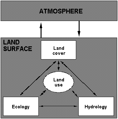
To achieve this objective, research is suggested under the following four Tasks (cf. Fig. 3):
1) Development of coupled models of ecological dynamics, hydrological processes and anthropogenic land cover/land use changes in complex mountain landscapes and river basins under current and changing atmospheric and socio-economic conditions. Efforts towards this objective will benefit from progress made in the land use/cover change modeling community, in particular, their efforts to develop improved theory and empirical methodology for coping with heterogeneity (LUCC Scientific Steering Committee 1999). Where appropriate paleo-data are available, these will be used to constrain and evaluate the models under different conditions of climate and land cover (Task 2.1);
2) Development of regional scale atmospheric models for mountain regions capable of providing high resolution areal distribution patterns of atmospheric driving forces, in particular precipitation, for the study of land surface processes (Task 2.2);
3) Integrated analysis of environmental change in mountain regions by means of fully coupled land surface-atmosphere models, where feasible and appropriate, or by qualitative assessments (Task 2.3);
4) Regional scale mountain land surface experiment to support the development, application and validation of the above models (Task 2.4).
In the context of Activity 2, it will be important to identify those changes in mountain land and/or water resources that are driven by environmental change and bring about changes in the ability of a given region to support current and future livelihoods. The paleo-record provides the potential to document such changes and their impacts on time scales that are at one and the same time beyond the reach of direct observations, yet well within the time frame of direct concern for future sustainability.
In these studies, particular attention will be placed on those characteristics that are of particular interest for sustainable development in view of global environmental change (cf. Activity 4), namely:
changes in forest resources (area and/or composition and structure),
intensification and/or extensification of agriculture (including grazing), with implications for food security, availability of water resources (quantity and quality), rates of erosion, slope stability, magnitude of floods, and biodiversity;
changes in water regimes and resource availability due to factors such as changing agricultural practices, increasing permanent or temporary population, and/or increasing energy generation with implications for downstream water supplies, energy generation, flooding and sediment transfer.
Consequently, special models to describe these key systems need to be developed (Task 2.1) and applied (Tasks 2.1, 2.3, 2.4), and their sensitivity to global change processes needs to be examined based on comparative regional case studies. Again, paleo-records could be very helpful in testing the capabilities of the models to represent
a) the interplay between climate variability and changes in glaciers, water cycles, vegetation, soils and the intensity of exploitation by human populations
b) the implications of processes operating on decadal or longer time scales
c) non-linear system responses within the complex interactions under study
d) changes in magnitude-frequency relationships and their consequences in terms of resource depletion and of hazard to human populations.
Mathematical models represent hypotheses regarding a set of processes. Therefore, their testing and evaluation through field studies needs to be an iterative process, and models should be viewed as continuously evolving rather than static research tools. Model development should always be performed in close collaboration with monitoring (Activity 1) and process studies (Activity 3), taking into account the complexities generated by topographic diversity and the associated steep and interacting environmental gradients. The co-evolution of regional-scale modeling and monitoring strategies has clear linkages to the IGBP Land Use and Cover Change project’s framework which emphasizes the flow of information between intensive case studies, extensive direct observations, and integrated models.
Moreover, modelling activities are always problem- and scale-specific. Hence, it is not suggested that one single model structure should be developed that could be used for answering all the different questions. But basic capabilities such as the ability to generate altitudinal gradients of climatic and ecosystem processes will always be essential for their application in mountain research. An important aspect will be to study, for instance, the temporal evolution and spatial manifestations of hydrological and ecological changes that have occurred as a result of climate changes in the past, such as across the Holocene.
Background
In mountain regions, changes of ecosystem structure and composition, ecosystem function, hydrology, and land use are intimately linked with each other and have strong impacts on the overall functioning of these regions (e.g., Cernusca 1989). If critical thresholds are exceeded within one of the subsystems, dramatic and often long-lasting impacts may occur in other sub-systems (e.g., increased surface runoff may lead to landslides, which change landscape pattern, carbon balance, vegetation distribution, etc.). Therefore, models capable of describing these processes and interdependencies, their spatial variability and effects are required (cf. Fig. 3).
Objectives
To develop, test and apply coupled ecological, hydrological and land use models for the simulation of land surface processes in complex mountain landscapes and river basins under current and changing atmospheric conditions and land use.
To combine descriptions of the dynamics of ecosystem structure, biogeochemistry, hydrology, and land cover/land use, to effectively explore mountain ecosystem linkages and their response to changing climate and land use.
Implementation
There is a number of challenges to the development of coupled ecological, hydrological and land use models in mountain regions and to the testing of their capability to represent the observed altitudinal variation along mountain slopes (cf. Box 3). These include
linking models of ecosytem structure with biogeochemistry models: Historically, most modelling attempts have focussed on either structural aspects of ecosystems (e.g., Shugart 1998), or on biogeochemical cycling (e.g., Running & Coughlan 1988). Recent models that address these linkages (e.g., Friend et al. 1997, Bugmann et al. 1997) need to be developed and tested further.
incorporating the interactions between different life forms of plants and their altitudinal variations in a single model: There are large gaps in space and time that need to be bridged in modelling competition between different life forms such as grasses and trees (e.g., Fulton 1993).
linking combined models of ecosystem structure and function with hydrological models: The integration of hydrology (water fluxes) and biogeochemistry (specifically, carbon, and nitrogen fluxes) has reached a preliminary stage (e.g., Band et al. 1991, Krysanova et al. 1998, Baron et al. 1998). But the specific flow paths that water and associated biogeochemical fluxes take in mountain environments are not yet fully understood and accordingly not adequately described in the models. Moreover, predictive models of ecosystem structure have hardly ever been coupled to hydrological models.
incorporating the impacts of land cover/land use changes on ecological and hydrological dynamics as related to altitude and other mountain-specific attributes. A number of studies exist on the impacts of drastic changes in land cover/land use, such as deforestation and urbanization, on regional climate and hydrology. Typically, these changes are represented in ecological and hydrological models by imposing land cover/landuse masks (i.e., scenarios of change). However, it is difficult to predict anthropogenic land cover/land use dynamics as such; this applies particularly for the complex conditions in mountain regions.
A number of challenges arise in integrating land use and cover change into ecological and hydrological models. Models must be able to simulate, for example, the long-term effects of different harvesting regimes on vegetation structure, biogeochemistry, and hydrological properties. Moreover, where consequences are cumulative but non-linear, and their detection and impacts are deferred only until critical thresholds are transgressed, the longer time perspective of paleo-research may be invaluable, especially for the collaborative work between present day ecologists and paleo-scientists.
|
Box 3: Basic Requirements for Ecological and Hydrological Models. To provide predictive hydrological and ecological models in mountain regions, altitudinal gradients have an important role because they provide a unique means for testing ("validating") such models along systematically changing environmental conditions. Specifically, these models need to fulfill the following requirements:
To evaluate the behaviour of hydrological and ecological models along altitudinal gradients, a series of studies should be conducted in different mountain regions. It would be desirable if these studies could meet a part or all of the following requirements:
|
There is a number of fundamental requirements that ecological and hydrological models need to fulfill if they are to become part of regional integrated models of mountain regions (cf. Box 3). Taking into account that less than 5% of all ecological studies are longer than 5 years (cf. Kareiva & Anderson 1988), the modelling activities proposed here need to be closely coordinated with the long-term monitoring and process studies conducted under Activities 1 and 3, and especially with the research on past dynamics based on paleo-records as outlined above.
Background
Spatially explicit studies of ecological, hydrological and socio-economic processes as influenced by environmental change are crucially dependent on the availability of high-quality atmospheric data sets. Such assessments are particularly essential in mountain regions due to their complex topography, but at the same time they are extremely difficult, especially with respect to precipitation. Regional scale models of atmospheric processes that have an explicit interface to land surface properties and processes and take into account information and data from ground based monitoring systems can be very helpful to address these issues.
Objectives
To develop, test and apply regional scale atmospheric models for mountain regions which provide more reliable areally distributed data fields of the atmospheric variables, in particular precipitation, and of land surface processes, taking into account the interactions and feedbacks between terrestrial ecosystems and the atmosphere.
Implementation
High resolution mesoscale atmospheric models have now reached a state of development that allows us to apply them to realisticically describe the atmospheric controls of land surface processes, in particular precipitation, even in complex mountain landscapes (cf. Pielke 1984). The computed conditions are compared with available data and information from ground-based stations and networks in order to detect discrepancies and take steps to overcome them by applying, for instance, the water balance check as suggested in Becker & Bugmann (1997), and other appropriate approaches.
The models will be used to investigate the blocking and uplifting of airflow by mountains, i.e. their influence on the larger scale atmospheric circulation and on the resulting regional climate in different climatic zones, different parts of the mountain region (upstream, centre and lee), and during different seasons and weather conditions. Suggestions will be developed as to how to adequately represent mountain regions in general circulations models (GVMs), and how to use the high resolution regional models in mountain areas to determine operationally and on a routine basis the spatial patterns of atmospheric variables, especially precipitation.
Another relvant aspect is the reconstruction of paleoclimate by means of paleoarchives from which atmospheric trajectories and sources may be inferred, such as ice cores and, less directly, lake sediments. In both of these, but especially in the former, the stable isotope record often contains a distinctive 'signature' from which precipitation sources and trajectories can be inferred. The changing types and concentrations of different atmospherically derived contaminants in both ice cores and lake sediments may also provide evidence for air mass sources and trajectories.
Background
It is increasingly recognized that changes in land use/land cover and atmospheric conditions interact with each other (cf. Fig. 3). Therefore, in many cases the widely applied downscaling approach that starts from large-scale circulation patterns being fed into limited area climate models, in order to provide regional and local changes in the climate, which are then used to determine the resulting impacts on mountain systems, is inappropriate when applied to GCM climate change scenarios. Rather, a consideration of the interactions between atmospheric characteristics and land use/land cover is required to describe their changes at the regional scale (e.g., Pielke et al. 1993, Stohlgren et al. 1998). Hence, research activities conducted under Tasks 2.1 and 2.2 need to be coupled to arrive at integrated assessments of the overall effects of environmental changes on mountain regions and the feedback from those regions to larger scales (i.e., continental and global).
Objectives
To assess the impacts and feedbacks of environmental change in different mountain regions of the world, taking into account the dependencies between atmospheric dynamics and land surface processes at a range of spatial and temporal scales.
Implementation
Integrated analyses of environmental change in mountain regions can be achieved in two ways: (1) by explicit "on-line" coupling of dynamic models of all the subsystems (Fig. 3), thus giving rise to fairly large, complex models; or (2) by coupling research results gained under Task 2.1 and 2.2 in an "off-line" mode, i.e. by synthesizing the new knowledge and incorporating it in the relevant submodel. Depending on the research questions being asked and the existing expertise and modelling tools, integrated assessments of the impacts and feedbacks of environmental change may be achieved for a given mountain region. As a matter of fact, the results from a carefully derived qualitative assessment can be superior to those obtained from very complex quantitative models that are faced with difficult questions relating to error propagation, etc.
The concept of modular modelling should be applied, so that modules can be exchanged easily and simulation models can be set up that allow us to answer specific questions in different mountain regions, based on the different availability of input data.
Clearly, the mountain specific strong variation of physical and ecological forcings and responses to environmental change needs to be taken into account in modelling mountain landscapes. Three different scales are most relevant here: (i) the hillslope scale, (ii) the valley or headwater basin scale, and (iii) the regional scale. Modelling coupled with monitoring in mountain environments at these different scales should provide information on (1) scale dependent process characteristics, (2) scaling rotations, (3) background levels of variability required to detect significant trends and environmental change impacts at the different scales, and (4) the dynamics of emergent properties of ecosystems that are scale-sensitive, including natural hazards, such as floods, fires and debris flows (cf. Task 3.2). To avoid misinterpretations, strong links between these investigations and monitoring and process studies as suggested in Tasks 2.4 and Activity 3 are of paramount importance. Only integrated interdisciplinary monitoring, experimentation and modelling is likely to be capable to provide the required information on mountain ecosystem processes and guidance for the sustainable management of mountain resources.
The degree of similarity of the integrated modelling and monitoring systems across sites within a global mountain network will depend on several aspects: (1) the scales of the systems being studied; (2) the ecological or hydrological questions being asked; (3) the socio-economic pressure being placed on the mountains (e.g. national parks in the U.S. and Europe vs. agro-forestry in the Himalayas). However, having a core data set at each site and the scaling capabilities of ecological and hydrological models can ensure a sufficient degree of cross-site comparability to function as a global network to document environmental changes.
Once validated, the models will be used to generate new hypotheses concerning ecosystem dynamics, to estimate responses to environmental change 'stressors', to suggest and assess improved management strategies, and to evaluate ecosystem sensitivity or thresholds, which in turn could improve the efficacy of monitoring programs.
Background
Large field experiments have proven to be an important tool in the investigation of land surface processes, their spatial and temporal variability and their interaction with the atmosphere. Several such experiments have been implemented during the last fifteen years, such as HAPEX-MOBILHY in southwestern France, FIFE in Kansas/USA, EFEDA in Spain, HAPEX-SAHEL in Niger, BOREAS in Canada, and LBA in the Brazilian Amazon (still ongoing). All these experiments were set up in more or less flat or only hilly terrain. Due to their complex topography, mountain environments up to now were considered to be too complicated and therefore to be investigated later. It is now timely to plan such an experiment in the frame of the IGBP Mountain Research Initiative, which aims at better understanding and adequately modelling meteorological, hydrological and ecological processes in mountain environments and their interdependency and interaction at different scales.
Objective
To implement in a mountain region a regional scale field experiment that provides reliable data for the development, application and validation of integrated land-atmosphere models (cf. Task 2.3) for mountain regions/river basins.
Implementation
Considering the special requirements in the preparation and implementation of such an experiment, a careful planning is necessary in cooperation with the experienced IGBP and GEWEX/ISLSCP scientific communities. The selection of a mountain region where the conditions for the implementation of the experiment are best or appropriately fulfilled will be initiated as the immediate first step of this Task.
Ecological and hydrological field studies and experiments, including manipulative ones, along altitudinal gradients and at sensitive sites (e.g. high elevation catchments) can provide invaluable information and data on potential responses of mountain ecosystems to anthropogenically induced environmental change as well as increasing understanding of the biotic feedbacks that accompany environmental change and influence mountain ecosystem function and hydrological processes (cf. Clausen 1948, Mooney & Billings 1965, Rawat & Purohit 1991, Prock & Körner 1996). In particular, such experiments provide the required basis for modelling efforts (cf. Activity 2), for the identification of ecological and hydrological indicators of global change along altitudinal gradients (cf. Activity 1), and for the assessment of the sensitivity of the ecological and hydrological systems to environmental forcing factors. This effort also aids in our understanding of the biotic feedbacks that accompany environmental change and their subsequent influence on ecosystem function and hydrologic processes.
The agents of global change (e.g. climate change, land use change, atmospheric chemistry) vary in importance in different mountain regions. Therefore, studies are required in different regions and at different spatial scales from whole catchment studies to the hillslope and plot level, depending on the environmental factor of concern, the goal of the study, and the resources available for the research. Some studies may be more intensive and carried out at a few sites, while others may be less intensive and carried out in a broader network (cf. Fig. 2). A considerable body of research has already been conducted, and a lot of it is still ongoing. The studies conducted under the umbrella of the IGBP Mountain Research Initiative thus should make the best use of existing programs or networks (e.g. ITEX, EMAP, LTER, MAB, and Biosphere Reserves) to avoid duplicating research efforts.
The combination of experimental and direct monitoring approaches provides only a narrow time frame for process studies, many of which operate on decadal time scales or longer. Models may overcome this limitation, but only if they are grounded in reality. Part of the empirical basis for model development and validation and much direct evidence for the operation of longer term processes will come from paleo-studies, provided the Mountain Research Initiative can generate an environment within which experimental, observational, modelling and paleo-endeavours interact in an iterative and mutually reinforcing manner. Research devoted to, for example, reconstructing variability from (1) dendroclimatological studies, (2) past ecotone shifts, (3) Equilibrium Line Altitudes (ELA's) in glaciers, and (4) species composition changes in terrestrial and aquatic ecosystems in response to climate forcing, may contribute to developing a more realistic sense of the full range of interacting processes that affect mountain systems.
Background
The high degree of ecological change across relatively short spatial gradients in mountains provides a useful framework in which process studies associated with global environmental change can be done. Process studies and experiments are a critical step to identifying specific responses of ecosystems to directional changes in the environment brought on by human activities. Concurrent measurement of climate, atmospheric chemistry, water, energy, carbon and other gaseous fluxes between the land surface and the atmosphere, and of hydrological and ecological properties within ecosystems will provide a correlational approach to detecting responses to environmental change. These studies should be complemented by experimental studies utilizing careful manipulations of the environment, and by paleo-data to elucidate long-term relationships.
Objectives
The overall objective for hydrological-ecological monitoring and manipulative experiments along elevational gradients in mountain terrain is to improve our process understanding of these unique systems insofar as they are sensitive to global change forcings. This knowledge can then be used to
derive biological and hydrological indicators sensitive to particular environmental forcing factors;
provide experimental information on the potential response of ecosystems to global change to improve modeling efforts;
facilitate a process-related interpretation of historical and paleorecords.
Implementation
The appropriate selection of environmental drivers to be studied in a given region is essential and should be emphasized in determining the research approach. Below, recommendations for research questions are given together with approaches that should be used to achieve the goals of this Task. Also here, the experiences from the ITEX project (Henry 1997, Henry & Molau 1997) will be quite valuable:
A. Climate change and its impacts:
Basic meteorological monitoring and synthesis to analyse climate change and variability: Climate change in mountain regions may be expressed through a wide range of phenomena, including changes of averages, variability, seasonality, the incidence of extreme events, the form of moisture (snow/rain partitioning), etc. What do we already know about these climate changes in mountain systems? How do these changes vary along altitudinal gradients, and how do they affect plant growth, moisture availability, or runoff?
Climate manipulations: Experimental modification of climatic parameters should be used to simulate anticipated future changes, which will serve to answer questions like: What changes in biotic composition and function will accompany climate change? What feedbacks will these have on biogeochemical and hydrological processes?
a) in-situ warming:
a) ITEX chambers (Marion et al. 1997, e.g., decrease convective cooling in herbaceous systems)
b) IR heat lamps (e.g., Harte et al. 1995)
b) in-situ cooling and precipitation increase (e.g., snow fences)
c) microcosms: controlled environment experiments- greenhouses and growth chambers with intact chunks of communities.
Altitudinal gradients as a proxy for climate change and gradients across slopes differing in exposition (at the same elevation): Such studies can be employed to examine the phenotypic and genetic responses of species (e.g. Callaway et al. 1994). A possible restriction here is that these gradients need to be relatively short, because p(CO2) and UVB also change systematically with altitude.
Stream and lake water chemistry as sensitive indicators of climate change, integrating the response and subsuming the variability of individual catchment processes: Stream chemical changes in baseflow composition will reveal alterations to the systems that cause changes in subsurface contact time and moisture regime. By the same token, lakes exhibit such sensitivity and have the added advantage that it can be reconstructed continuously to the present day from the sediment record - as witness, for example, the essential contribution of paleolimnology to understanding acidification and eutrophication and the use of recent sediments to reconstruct phosphorus loadings. Where suitable lake sediment sequences exist, there are the added advantages of being able to establish pristine baseline conditions and trace longer term trends from the sediment record in increasingly quantitative ways.
Fluxes of water, energy and trace gases (especially C and O3) at the land surface/atmosphere interface: The sustainability of mountain ecosystems with respect to their carbon exchange properties need to be investigated on a long term perspectives. Changes in climate and extreme events can significantly affect the carbon fluxes of high altitude ecosystems, altering net ecosystem production, the rates of biogeochemical cycling, and the vulnerability to soil erosion. Long term carbon, water and energy flux stations in mountain regions will be used to assess the intra- and inter-annual variability of gaseous exchanges. They will supplement the monitoring system used for the analysis of the impact of environmental changes on ecosystems functions, in particular the FLUXNET initiative. - A special aspect is ozone formation by high altitude ecosystems, which have a significant role in the oxidation capacity of the atmosphere. Due to the high radiation load and the significant rates of biogenic volatile organic compound emission by mountain vegetation, there is a high potential for ozone formation at high altitudes. In regions where the anthropogenic impact determines high NOx emissions (e.g., the European Alps), the potential for ozone formation becomes very high as evidenced by the increasing trend in recent years. These processes and associated management and mitigation will be studied.
B. Increases in N deposition
What changes in terrestrial and aquatic ecosystems will occur as a result of increasing N deposition? Will invasive species become more abundant (Vitousek et al. 1997)? What impact will community changes have on ecosystem function (Bowman & Steltzer 1998)? Will plants become more susceptible to stress under elevated N inputs (Aber et al. 1989)? What is the fate of anthropogenic N deposition, i.e., what ecosystem components will be sinks (or sources) for N? How does hydrology control N cycling? To answer these questions, the following approach is suggested:
Basic monitoring: both wet and dry deposition: e.g. bucket samplers (e.g., NADP network in U.S.), aerochem samplers
N fertilization experiments: low level (e.g. 1-10 g m-2 y-1) to mimic projected increases
15N pulse-chase experiments: determine uptake and loss of N by plants, microbes, and soil
d18O in NO3- as a tracer (e.g. Durka et al. 1994) used to separate the various sources of atmospheric N and cycling through the system
Hydrologic study of snowmelt recharge of high NO3- water: Does this water run-off during the melt season to the stream, or does it recharge groundwater that then contributes to stream baseflow some months later (Burns et al. 1998)? Understanding the coupling between the root zone and the lower groundwater zone will be important for interpreting stream NO3- dynamics and ecological processes in mountain environments.
C. Increases in UVB radiation
While plants from high altitudes appear to be better adapted to UVB irradiance than lowland plants, they may also be at the limit of biological adaptation to UVB. Differences in susceptibility among species will most likely lead to changes in community composition (Caldwell et al. 1998). What will these changes be, and what impact will they have on ecosystem function?
UV-B monitoring systems: need for long-term data on trends in mountain systems
UV-B lamps in field plots and controlled environment conditions.
Background
The hydrology of mountain areas is different from that in other regions of the world due to the steep terrain, special geological and soil properties, which control runoff generation and water movement. Topographic position is therefore an excellent surrogate for lateral flow direction and soil moisture distribution, since gravity dominates total water potential in steep terrain. Surface runoff (overland flow) and subsurface stormflow are flashy, with short streamflow response times to rainfall and snowmelt, and thus they can be generate floods. However, direct runoff generation mechanisms are still not fully understood. The spatial and temporal variation of soil infiltration capacity which determines infiltration excess overland flow generation is generally high due to the spatial heterogeneity of the land surface and difficult to model. The same is true for the determination of temporarily saturated areas where saturation excess overland flow is generated. Many of these areas vary dynamically in extent during rainfall events in dependence on soil thickness, texture, geological conditions and surface as well as bedrock topography.
Even more complicated and less understood is the generation of subsurface stromflow consisting of quick returning subsurface flow through preferential flow paths (macropores, pipes etc.), piston flow, ground water ridging where displacement processes of old (pre-event) water by event water play a major role so that, although the streamflow response times are short, residence times of the water are quite long. These residence times, however, determine the subsurface water contact time with the surrounding geologic material, and thus its chemical composition, i.e. water quality. All these processes and their interdependencies are not yet fully understood and further research is clearly required (Bonell 1998).
Another aspect concerns the runoff controlling linkage between vegetation and soil moisture, which is quite sensitive in mountain regions. Vegetation stabilizes the soil and affects the runoff process by reducing surface flow. If vegetation is removed, or changes its elevational extent, overland flow and erosion may occur and increase; this increases both streamflow and stream sediment concentration. Finally, narrow and highly incised valley-bottoms often limit the extent of riparian zones, a key landscape position for nitrogen transformation (Cimo & McDonnell 1997).
Objectives
To improve our knowledge of lateral flowpath dynamics on steep hillslopes and capability to model flow components contributing to streamflow.
To examine the role of biogeochemical ‘hot spots’ for N transformation in mountain areas (riparian zones, hollows, etc).
To test how digital elevation data can be used to model water redistribution in the mountain landscape and to identify soil moisture patterns and related influences of vegetation.
To use this combined understanding to identify key hydrological indicators of global change in mountain environments.
Implementation
The catchment as a fundamental landscape unit integrates many of the ecological, geochemical and hydrological processes that signal environmental change. Therefore, monitoring the water, sediment and nutrient fluxes in nested mountain catchments along altitudinal gradients enables quantification of ongoing and future potential changes (e.g. the U.S. LTER program, EMAP, etc.). Paired watershed studies in mountain environments will be used to quantify the effects of prescribed manipulations that simulate anticipated change phenomena (e.g. forest cover alteration), with one watershed kept unchanged.
Where the catchment framework includes lakes or reservoirs within which the output from the system has been continuously and efficiently trapped, the sediment record can provide both a spatial and a temporal integration of the environmental processes operating both on the land surfaces and within the aquatic system itself. This has many advantages, ranging from documenting human impacts and interacting processes on many time scales, to providing realistic targets for practical remediation.
The paired catchment approach has proved a valuable tool also in paleo-research, notably in identifying on a continental scale the dominant factors responsible for widespread surface-water acidification. This implementation strategy therefore provides a basis for both contemporary and post-hoc experiments, and a powerful tool for uniting the methodologies and perspectives required to address the challenge of future environmental change in mountain regions.
Most of the studies as proposed above require the coordinated application of multiple approaches including conventional monitoring, advanced field experiments, tracer techniques, remote sensing, topographically-based modelling, nested catchment studies. Some aspects in monitoring should particularly be mentioned:
A. Measurements and experimentation, combined with modelling and remote sensing, to understand and improve models of
the spatial and temporal variation of soil moisture pattern and the occurrence and temporal variation during rainfall and snowmelt events of saturated areas generating direct overland flow taking into account topographical, soil, vegetation and other controlling features, including the "topographic index".
N-flushing in steep dissected mountain topography (cf. Creed et al. 1996).
B. Tracer techniques combined with modelling to identify subsurface flow paths, their dynamics, in particular travel times/residence times of the flowing water and associated substances:
The most essential tracers are:
d18O to assess the geographical source of stream flow in mountain catchments (Kendall & McDonnell 1998).
CFC and SF6 tracers to quantify groundwater and stream baseflow residence times and water ages (Plummer et al. 1994).
18O of NO3- to trace different sources of atmospheric N (Durka et al. 1994).
conservative chemical tracers at the hillslope scale, which help to identify the major flowpaths on mountain slopes (to be linked with modeling; cf. Anderson et al. 1997).
C. Paleolimnological studies:
Particularly where suitable lake sediment sequences are available, paleolimnological studies can be used to tie recent experimental and monitoring activities to sediment-based research. This applies specifically (i) to calibrate paleo-records, (ii) to get better insight into long term processes, and (iii) to contribute to the use of paired catchments as a study framework based on a post-hoc sediment-based approach.
Background
There is considerable debate about the role of diversity in controlling ecosystem properties and the effects of environmental change on this relationship (cf. Körner 1995b, Chapin & Körner 1995b). Mountain regions are very suitable for studies addressing this controversial topic because the strong changes in the existing biological diversity along altitudinal gradients can be used to assess biotic changes induced by environmental changes, preferably in an experimental framework. The relationship between function and diversity of an ecosystem, and how this will impact the response of the system to global change is a critical component, and is perhaps best addressed in mountain ecosystems. There is increasing evidence that changes in vegetation and soil microbial communities will mediate the response of ecosystems to environmental change, providing feedbacks that may be as important as the environmental change which initiated the biotic response. Thus, a better understanding of the link between diversity (defined variously as richness, combination of richness and evenness, or variety of Plant Functional Types [PFTs], e.g. Woodward & Cramer 1996) and function would facilitate our predicting the response of systems to environmental change.
Objectives
To elucidate the relationships between biological diversity and ecological function.
To determine how changes in diversity will feed back to the response of mountain systems to environmental change.
Implementation
Research under this task will be coordinated closely with the activities of the DIVERSITAS Initia-tive. In February 1999, a planning meeting for a "Global Mountain Diversity Network" was held in Switzerland, which laid down the conceptual principles and a plan for its implementation (cf. Körner 1999).
Elements of the implementation of this Task include:
Evaluation of changes in diversity along altitudinal gradients: How does diversity change along altitudinal gradients? Does the composition of PFTs change systematically and predictably with changes in altitude (Körner 1995b)?
Investigation of diversity-functional relationships along altitudinal gradients: How do diversity, productivity and resource use vary (Steffen et al. 1992)? Is there higher productivity and resource use in more diverse communities? Can sets of PFTs be defined that will be useful for predictive modeling studies (e.g., Bugmann 1996)?
As indicated in Section II, the overall objective of this initiative is to evaluate and enhance sustainable land, water, and resource management strategies for mountain regions. This Activity builds on the insights gained from the integrated investigations outlined in the previous three Activities; it aims to assess current strategies and contribute to developing alternative strategies that could lead mountain regions towards more sustainable development trajectories, taking particularly into account the impacts of recreational and touristic uses, which have become economically important for many mountain communities.
Sustainable resource management in mountain regions requires understanding that future changes will be driven simultaneously by global phenomena (e.g., greenhouse-induced climate change) as well as local and regional resource management schemes (cf. Fig. 1). Activities pursuant to this objective will provide the links between scientific understanding of processes of change and the consequences of those changes for adaptation and mitigation options. As depicted in Fig. 1, we are particularly interested in the feedback between management strategies and trajectories of change, especially as such feedbacks threaten the ability of specific regions to support current and future livelihoods.
Three priorities are suggested for assessment (cf. Activity 2):
changes in forest resources, with potential implications for agriculture, rates of erosion, slope stability, and magnitude of floods, and biodiversity;
intensification and/or extensification of agriculture (including grazing), with potential implications for food security, rates of erosion and magnitude of floods, and biodiversity;
changes in water resources due to factors such as changing agricultural practices, changing seasonal or permanent population size, where the former is often due to tourism, or increasing energy generation, with implications for downstream water supplies, energy availability, flooding, and sediment transfer.
Work on these linked themes must involve local people in defining and implementing research, recognizing the complementarity between local knowledge and scientific investigation. Approaches such as "Participatory Rural Appraisal" (Mukherjee 1993) should be used to determine local people’s perceptions of environmental change, and their related needs and priorities. The results of these efforts should be tightly linked to the research activities aimed at determining best practices for ecosystem management:
evaluating optimal combinations of traditional and innovative resource management systems, in order to ensure the stability and resilience of both natural and human-managed ecosystems and the conservation of biodiversity;
assessing appropriate institutional arrangements, based on understanding of traditional arrangements, the processes which contribute to changing them (including tourism), and the alliances and interactions between mountain communities and interest groups at different levels;
evaluating economic instruments to achieve a new balance between production and the provision of societal benefits in relation to driving forces of global change, including climate change (especially changing frequencies of extreme events), migration, and the evolution of communication networks.
Historical perspectives also provide valuable means of exploring the sustainability of resource management strategies. Many mountains of the world have a long history of human influence, e.g. some 5’000 years in the European Alps, and more than 10’000 years in Central America and the Andes. There is a strong relationship between the natural environment and human activities during these times. The interaction and feedbacks between human activities, land use, climatic and environmental change, and disastrous events are recorded in paleorecords in these areas. Reconstructing and understanding these interactions provide an important foundation for the development of sustainable management schemes for the future.
Background
Mountain forests are changing in extent, structure and composition at an accelerating rate under the influence of forces associated with both global change (e.g., climate variability, increasing nitrogen deposition) and local and regional management strategies (e.g., intensification of resource extraction, exclusion of fire). While forest cover is declining in most of the world’s mountain systems, there are significant deviations from this trend. Over the last 100 years, forests have been reestablished on abandoned agricultural land in eastern North America and western Europe. Over the last several decades, forest restoration projects have had local success in mountain regions in both Asia and Latin America, with benefits to local economies as well as downstream water quality.
This Task addresses the sustainable management of forest resources, recognizing that they form a major component of many mountain economies. The scope of this Task is broadly defined to include resource extraction activities and concomitant modification of forest ecosystems that range in intensity from collection of firewood, non-timber forest products and construction materials, to small-scale selective logging, to commercial logging and species conversions; as well as from short-term to permanent conversion to agriculture. The Task is complementary to those in this document that investigate agricultural systems. For example, forests and agriculture are linked by nutrient flows from forests to agricultural systems (e.g., organic input into agriculture derived from forest products) as well as the linkages in transition states between forest and agriculture in land-use dynamics.
The relevance of this Task is threefold. First, successful sustainable management of forest resources has direct economic benefits to stakeholders, including local communities and other land owners, forest product firms, and regional and national governments. Second, forested mountain watersheds provide services to adjacent lowland communities (Price 1990), such as maintaining water quality (Hamilton & Bruijnzeel 1997) and mitigating hazards (Mayer & Ott 1991, Hewitt 1997). Third, management of mountain forest resources is of increasing importance as an international policy issue driven by the role of deforestation as a source of greenhouse gases and by the recognition of the role that maintaining or renewing mountain forests might play in sequestering carbon (e.g., Lasco & Pulhin 1998).
Objectives
To assess the consequences of changes in forest area, composition, and/or structure for a suite of linked issues including, but not limited to, sustainable harvesting practices, production of non-timber forest products, tourism, watershed protection, conservation of biodiversity, and carbon storage vs greenhouse gas emissions.
To develop sustainable forest management practices by using models developed under Activity 2 that consider changes in forest resources due to potential environmental change.
Implementation
This Task seeks to integrate scientific findings and models with resource management strategies at local, regional and global scales. Several implementation issues arise from this integration:
Case studies must be organized to simultaneously account for covariation in key biophysical driving factors with altitude (e.g., Koch et al. 1995a,b, Becker & Bugmann 1997) as well as gradients in land-use intensity (e.g., Lebel et al. 1998). Unlike biophysical gradients organized by elevation, land-use intensity gradients are conceptual, organized by gradations in intensity of use. In order to examine covariation of land-use intensity and biophysical gradients such as temperature, comparative case studies would be located according to both a spatial gradient in temperature as well as the gradient in land-use intensity. In many mountain regions, such comparative case studies can take advantage of pairing altitudinal gradients in biological reserves, where human modification is minimal, with altitudinal gradients in locales with intensive human use. Biosphere reserves, which themselves include gradients in land use intensity, may be particularly appropriate for such studies. Research under this Activity will benefit greatly from co-ordination with GCTE Focus 3 efforts to understand global change impacts on agriculture, forestry and soils, as well as LUCC Focus 1 efforts to understand processes of land use change, and Focus 2 efforts to define land-cover change ‘hot spots’.
A number of studies document the influence of local factors on patterns of forest resource use; e.g., the well-documented relationship between road construction and deforestation (Hamilton & Bruijnzeel, 1997). However, we need an improved understanding of how external drivers, operating at multiple scales and associated with urban centers (e.g., markets; trade policies) influence land-use changes in more remote forest regions. Extra-local factors that are known to influence forest management schemes include commodity prices, policies and programs to develop rural infrastructure, and property regimes. As an example, we need a better understanding of how economic growth and urbanization influence demand for grazing land to produce meat, or tree plantations for pulp and lumber production. Research under this Activity will benefit greatly from coordination with LUCC Focus 3 activities as well as IHDP activities.
Background
Mountain agriculture systems are often perceived as particularly vulnerable to global change due to such factors as:
low productivity due to short growing seasons and soils of low fertility;
limited accessibility due to terrain conditions, seasonal hazards, and high cost of transport;
limited scope for resource-use intensification and upgrading through infrastructure due to terrain constraints; and
limited opportunity for production gains associated with scale of operation (such as green revolution of lowlands; cf. Jodha 1997).
These factors are likely to increase in importance as demands for food increase due to increasing population and affluence. In many mountain regions, trajectories are likely to occur towards increasing intensification of agriculture and, especially in developing countries, further conversion of forest to agriculture. These trajectories become non-sustainable when conversion and intensification lead to land degradation and decreased food security. Embedded in this issue is the role of natural climate variability as it influences agriculture production. A full understanding of the diverse interactions between climate and food production must account for socio-economic factors - such as access to irrigation, and indigenous or new soil and water conservation practices that make production systems more or less vulnerable to climatic variation (Liverman 1992, 1994, Price & Barry 1997).
Objectives
To assess the vulnerability of mountain agricultural systems with respect to environmental changes, especially as they are modified in their impact by social and economic factors.
To suggest ways for integrating agricultural development with growing demands for water, energy, and biodiversity conservation by using models developed under Activity 2 to explore interactions between agriculture systems and regional patterns of land and water use.
Implementation
This Task seeks to integrate traditional crop model-based assessment of agricultural productivity with a broader set of factors that govern sustainability of productivity as well as landscape-scale environmental implications of changes in agricultural production. As such, elements in the implementation of this Task must include the following:
A strong strategy for linking agricultural production to biophysical and socio-economic factors that influence sustainability is to identify key sources of vulnerability of a regional agricultural system to climate variability (e.g., Downing 1995, Liverman 1992, 1994, Jodha 1997). Factors to be considered in assessing vulnerability include intensity of land and water use; traditional and new soil and water conservation measures; effects on water resource availability (quantity and quality);population immigration into marginal areas; tourism; access to economic resources; dependency on external economic resources; feasibility of traditional production systems; infrastructure for hazard response; and health status of potentially affected populations.
Intensification of agriculture almost always leads to a sharp loss of biodiversity at a local level, and very often involves the introduction of alien species as part of the production system (Walker & Steffen 1997). Traditional mountain agricultural systems are characterized by high diversity in terms of microclimate, crop varieties, land-use patterns, and agronomic techniques (Jodha 1997, Ramakrishnan & Saxena 199x, Swift 1996). Increasingly, traditional systems are reduced in diversity as a result of efforts to increase production and in the shift from subsistence to commercial production. A key question that arises from these trends is the degree to which the diversity of mountain agriculture systems, at genetic, species and landscape levels, is related to trends in food security and overall sustainability of livelihoods (Swift et al. 1996).
Intensification of agriculture is often associated with changing spatial arrangements of agricultural elements, non-agricultural land use, and infrastructure (e.g., change in field size) with consequent impacts on biodiversity, water resources availability, and provision of fresh water, soil stability, retention of nutrients, flood control, and propagation of pests and diseases. The sustainability of agriculture is thus linked to other resource issues, especially water supplies and flood control. Integrated analyses that link and assess consequences of change in these systems are of particular importance in mountain regions as ‘high energy’ hydrologic and geomorphic environments.
Research on all of these issues will benefit greatly from co-ordination with the IHDP Science Project on Global Environmental Change and Human Security (GECHS). Further, the case studies developed under this Task will address the LUCC Focus 1 objective of identifying institutional, economic, political, and biophysical conditions that exacerbate vulnerability.
Background
Mountain regions have been referred to as 'water towers for the 21st century' (Mountain Agenda 1998), reflecting the fact that more than half of humanity relies on fresh water that accumulates in mountains for domestic use, irrigation, hydropower, industry, and transportation. Mountains play a disproportionate role, relative to their area, in the global hydrologic cycle due to the key role of topography in triggering orographic precipitation. Further, mountain systems store water as snow and ice during the cold season and distribute water to lowlands during the warm season when demand from plants is often critical (Bandyopadhyay et al. 1997).
Assessing the sustainability of water resources requires integrated analyses of trends in supplies and demands. Several aspects of Activities 1 through 3 address the impact of climate variability and land-use change on water supplies. The contribution of this Task is to integrate those analyses with assessments of the potential ways in which increasing population and consumption may increase demands above levels of supply. The Task also addresses how changes in climate and land use/land cover may alter not only the quantity of water, but also the quality and/or timing of water flow which, in turn, has implications for sediments as major pollutants of surface waters, and for increased flood hazards - especially those resulting from the interaction of extreme meteorological events and land use.
Objectives
To assess the interacting impacts of human activities and of their consequences at all relevant scales on mountains on the regional water resources.
To assess options for managing increasing demands for fresh water, including downstream demands, while safeguarding other mountain resources, including agricultural and agroforestry systems and biodiversity.
Implementation
This task seeks to integrate models as developed in Activity 2 with a suite of factors that influence variation in water supply and quality as well as variation in patterns of demand. Elements to be considered under this Task include:
The various interdependencies and interactions between land use/land cover, and thus forest and agricultural management practices as mentioned before, and hydrology and water resources availability in quantity and quality need to be assessed adequately in the integrated models to be applied.
Assessment of the sustainability of water resources must explicitly account for interactions between mountains as sources of water and lowlands as generating demand. This relationship is made more complex as increased development within mountain regions reduces the quality and quantity of flows downstream on which lowland communities depend. In addition, changes in the frequency of extreme events due to climate change must be considered.
The sustainability of water resources is increasingly influenced by the potential for conflict when water flows across political boundaries between regions and nations. World-wide, 214 river basins, serving 40% of the world’s population, are shared by two or more countries (Mountain Agenda 1998). A key research question in this area is an assessment of how various institutional arrangements foster reliable and equitable distribution of water among different interest groups.
Research on these issues will benefit greatly from co-ordination with the IHDP GECHS Science Project. In addition, research under this Task will benefit from coordination with the LUCC Focus 3 objective of developing suitable interfaces for linking hydrologic models with models of land use and associated socio-economic phenomena.
![]()
![]()
![]()