![]()
![]()
1.1 Geographical setting
Sri Lanka is located in the tropical zone. The pear shaped island is surrounded by Bay of Bengal in north and Indian Ocean on its eastern, western and southern flanks (Figure 1). The maximum length and width of the island is 435 km and 240 km respectively and the land area is 65 525 sq.km. The landmass of Sri Lanka is closest to the Indian sub-continent, where from it is separated by the Palk Strait with a width of about 32 km. (Somasekaram, 1997). The total length of the coastline is about 1 600 km. The coastal belt and the extensive marine area extend 370.4 km width of economic zone. The coastal region consists of a series of lagoons, marshes, sandbars, dunes, coral reefs and 113 islands. Beyond Dondra, which is the southern most end of the island, the vast stretch of ocean extends to the Antarctica landmass.
The present day physiography of Sri Lanka is represented by dominant physical highland feature of an anchor like central massif located in central southwestern region. The base of the anchor is the mountain wall facing south, and a complex of numerous high peaks with elevation 2 000–2 500 m and plateaux. The combined action of the natural processes of denudation, erosion and sediment of transport by physical forces of rain, wind and temperature fluctuations, have gradually brought a change in the physiography.
The island physiography can be described in form of the three distinct peneplains. The lowest peneplain, which is at an elevation of 75 m above sea level is most extensive, covering 75 percent of the total land area. The second and third peneplains occur at elevations of 125–750 m, and 750–2 500 m, respectively. These collectively constitute the central mountainous area.
The strategic location of the highland feature in central southwestern direction played a key role in determining the duration and quantity of rainfall in different parts of the country. This feature was one of the major criteria in demarcating the country into wet, intermediate and dry zones. The intensity and extent of natural denudation and erosion patterns created the physiographic feature of low country (below 300 m), mid-country (300–900 m), and up-country (above 900m). The low-country which is at an elevation of about 75 m above sea level is the most extensive, covering about 49 144 sq.km (75 percent) of the total land area of 65 525 sq.km. The low country falls in the dry zone areas in north central, Northwest, Northeast and Southeast directions.
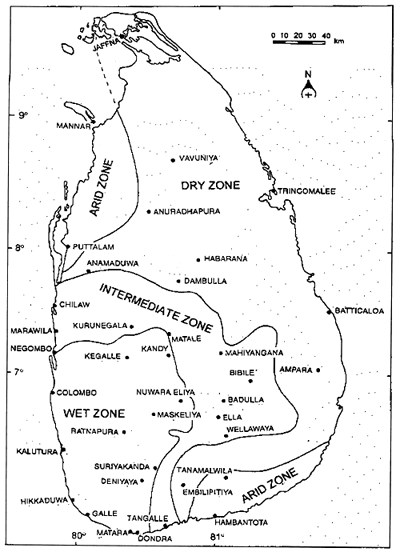
Fig. 1. Generalized Map of Sri Lanka.
The river systems, perennial as well as seasonal which descend from the up and mid-country region, transport mineral rich alluvium into the flood plains and helped in ground water recharge during the monsoon season
![]()
![]()