![]()
![]()
![]()
We have already mentioned in the introduction that the first of the series of active measures which can be taken against avalanches is that of placing isolated buildings, which would be in danger, elsewhere; and that the best form of passive intervention consists of good preliminary planning in order to avoid construction in danger areas.
Such humble and prudent policies are based on the most elementary common sense; their practice is, however, less simple than might be apparent. There are two preliminary questions which present themselves: that of knowing whether there are any places sheltered from avalanches and, secondly, a knowledge of reliable methods of determining a priori the limits of these safe zones.
Ski-tourers during the winter and spring generally believe that there is nowhere high in the mountains which is totally sheltered from avalanches or from their blast. Systematic observations carried out in certain areas where there were sufficient mountain experts available seem to confirm this view. One can, however, define areas where avalanches are less common, or avalanche paths where the likelihood of an avalanche is higher at the beginning, or the middle, or the end of the season. But all those who have had to choose a site for a mountain hut know that it is extremely difficult to find those few square metres required for its construction which will be sheltered from all surprises.
Nevertheless, as we descend towards the valleys, we find that avalanches are either stopped, or concentrated into certain areas by local topography, so that other areas appear to be safe and separated by well defined avalanche paths.
Since the end of the last century several European countries have been systematically observing these gulleys simply marked with a pencil on 1/80 000 or 1/50 000 maps.
From these observations, usually entrusted to foresters, some notion of avalanche frequency in certain gulleys has been deduced. These gulleys may be used as avalanche paths annually or every five, ten, fifty or hundred years.
The resulting file on these observations is, even today, of great scientific interest due to the statistical use which can be made of this information. The series of gulleys under observation, usually chosen for ease of observation from a convenient winter vantage point, forms a "statistical population" similar to the ensemble of gulleys which might be encountered on a massif in respect of their conditions in the starting zones (altitude, exposure, topography, vegetation, etc.). Complete and consistent observation allows us to establish whether such and such a set of snow or meteorological conditions has led to avalanches in such and such a proportion of gulleys under observation. We are entitled to believe that such a situation is indeed representative of the range of possible avalanche types in a given area.
Thus we see how accurate and well kept records have been of crucial importance to the progress so far achieved in the application of statistical methods for forecasting avalanche hazard.
Naturally this forecasting does not concern directly those foresters engaged in mountain defence works, but, as will be seen in the next chapter, these matters constitute an essential portion of the information required for efficacious methods of temporary defence through artificial release of avalanches. It is thus essential that these traditional observations should continue and be constantly improved upon.
For those responsible for construction work it is extremely important to know the damage caused and the furthest points reached by the avalanches one wishes to contain.
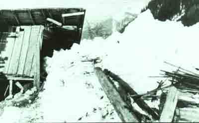
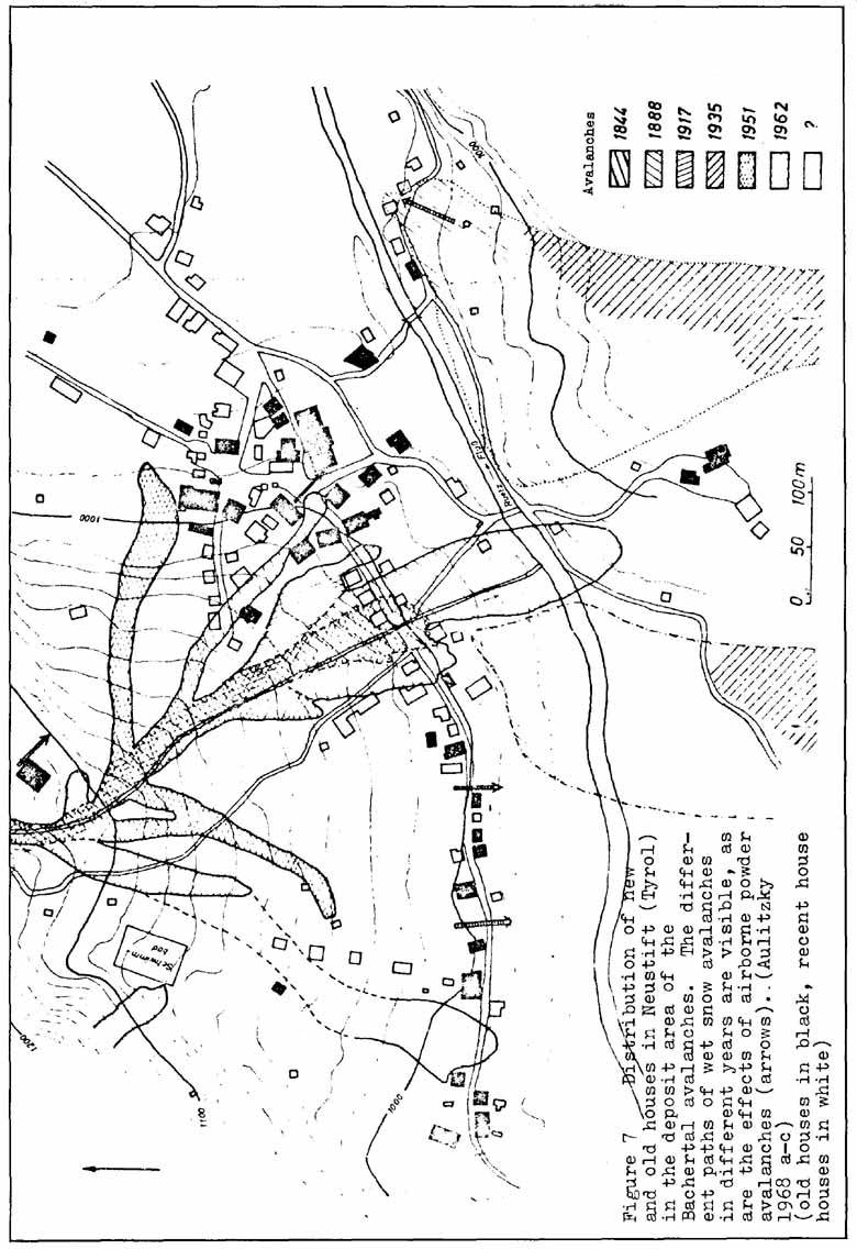
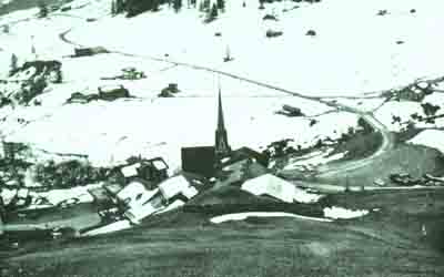
It is a popular myth that the mountain inhabitants of ages past had the gift of a "sixth sense", missing to our contemporaries, which allowed them to know exactly, to the nearest metre, where they could build in order to be sheltered from avalanches. A read through the ancient chronicles which relate the most monumental catastrophies caused by avalanches leads us to revise this myth quickly: mountain people of the past tried, just as we do now, to place themselves as judiciously as possible; they of course had an intimate knowledge of their environment which allowed them to avoid the most blatant mistakes. But they were never sheltered from surprise attacks. Their advantage over us was that they had a sort of "collective memory" in the form of an oral tradition which allowed them to avoid settling in an area where there had been an avalanche even if this had occurred centuries before. The mobility of modern populations, and the influx of people from cities to their second homes, have extinguished this tradition.
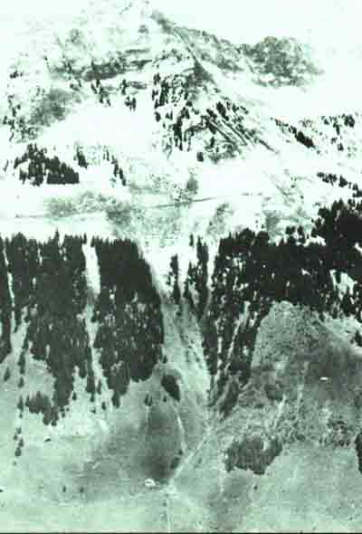
Figure 7, which is taken from the work of Professor Aulitzky and published by the Council of Europe, perfectly shows this "loss of memory" on the part of modern builders.
It is therefore important that the public authorities should supplement and complete this oral tradition. For a lone time now attempts have been made in several alpine countries to keep a large-scale survey (1/20 0001/10 000) of avalanches and of the exact limits reached by them throughout recorded history. This work has been relatively easy for comparatively recent avalanches near centres of habitation. This has allowed records to be kept which are invaluable to urban planners who might have to authorize extensions to buildings on the edges of villages and mountain resorts.
It is indispensable that such work should continue mad also be extended to the new resorts recently built for winter sports. In a few of these a permanent system of avalanche observation has been created for those avalanches which have reached the area where future development could take place. A secondary, but precise network of triangulation points is necessary in order to have a sufficient density of visible points and coordinates during winter. Each time an avalanche reaches the area where urbanization is assumed to be probable, a specialized team should hurry to survey the intruding tip of the avalanche in order to mark this on the map. Thus a precise and incontestable record is kept of the avalanche path which otherwise, consciously or not, people would be likely to forget.
All the information, ancient documents, reports, maps, photographs, surveys, investigations relating to an avalanche path must be kept in a single, centralized organization and filed by individual path or gulley. This is the only way in which one can remedy the voluntary and involuntary deficiencies in the local collective memory.
Since avalanches are always extremely sudden events, the genesis of which occurs in areas of difficult access, there is not a great deal of observation of avalanches during their actual movement. Generally we are left to look at their trail, particularly in the area where they have spread out and deposited, but there is in the main little information about the starting zone. It is only by beginning with a detailed knowledge of this area, with its snow cover, that the planner of avalanche defences will be able to accomplish his work. These same elements will allow the planner to estimate the mass of snow set in motion by the avalanche he wants to divert (see Chapter V, paragraphs 3.2 and 3-3), or for which he wants to calculate the extent of its deposit (see formulae annexed to Chapter V).
But the direct observation of avalanches is not possible everywhere. Certain mountain areas for which there are important development projects on the drawing board are still unfrequented during the winter, and information thus tends to be fragmentary and incomplete. This is a far cry from the precision and reliability of the direct observations provided by the local traditions of inhabited areas. They do not provide us with an exact knowledge of the avalanches.
It is therefore necessary to go beyond this form of direct observation and to make an inventory of all the signs and clues, physically inscribed upon the land, which will reveal during the summer months the presence of avalanches in the past or even the threat of them in the future.
Causes or effects of avalanches, and many physical features observable on the ground, can be linked to avalanche starting, transit or arrival zones.
Slopes with a gradient of over 50° (120 percent) are rarely avalanche slopes for they discharge continually during each new snowfall. Slopes of less than 30° (58 percent) are extremely unlikely to avalanche (see Chapter II, paragraph 1.2.1). But even with the gradients being equal, the likelihood of avalanches in different places will not be the same, for there are numerous other factors which determine the likely lines of fracture.
a) Convex areas produce an increase in the rate of total motion of the snow cover down hill (by total a 1 motion we mean the combination of creep and Elide) (see Chapter II, paragraph 1.2.1).
When the snow cover is in a suitable condition for avalanche release (presence of a stratum of low shear strength), the fracture will initially occur in these convex areas where there is tension force within the snow cover.
b) Rock bands and cliffs interrupt the snow cover, weakening the top and side anchorages by the heating effect of the rock on the snow. They therefore favour the start of slab avalanches. In addition they are likely to cause bombardments of rocks onto the slope as a result of the effect of frost action.
c) Lines of rocks which barely protrude above the ground, when they are completely covered by snow, block total notion above them while it continues normally below them. This produces, in the upper and uninterrupted strata of the snow cover, traction forces which tend to localize the fracture of a slab along the line of buried rocks. This same phenomenon occurs when attempts are made to correct an avalanche starting zone with earth banks, terraces or walls. All obstacles which, because of the unbroken surfaces effect the deposition of snow, are at risk of becoming buried themselves during a heavy snowfall. They thus facilitate the start of avalanches above them. This drawback is rarer with obstacles that have openings in their surface, for they then modify snow deposition less and are consequently at less risk of becoming buried themselves. They will only facilitate the start of avalanches if they are badly designed.
As with factors concerning exposure to the sun, these factors too influence the movement of the snow cover over the ground. The following comments are then an explanation of Table 4 of the Guidelines, which are set out in paragraph VI.
a) Bare and smooth ground, especially if it is wet, favours snow glide and therefore increases all the stresses within the snow cover, making avalanche release more likely.
b) Broken or rough ground, stones and large boulders are efficient brakes on snow glide by simple mechanical effect. Moreover they maintain a circulation of air under the snow which blocks the rise of warmth towards the snow/ground interface. It is only in these places that one might find, at medium altitude, temperatures below freezing beneath a snow cover of reasonable thickness. The snow will therefore be less wet. There are therefore two factors which in conjunction make full-depth avalanches less common in areas with large boulders. Generally, only surface avalanches will start in such areas and they usually take less material with them and do not travel as far.
c) Pasture terraces and "cow trails" formed horizontally by the passage of herds have a positive action in blocking snow glide, an effect which has on occasion been produced artificially by dig-gin's ridges. On the other hand, we find with certain types of ground, especially clay, that too good an anchorage between snow and turf produces a shear fracture which no longer occurs within the snow, but underground, in the area just beneath that which is strengthened by the grass roots. A mixed snow and earth avalanche is therefore released. The areas where turf has been torn away will duly be sites of erosion during the summer. Occasionally we see horizontal lines of erosion which can be signs of frequent release of avalanches at a certain level.
d) Wet areas, usually due to ground water surfacing, or sometimes to a badly kept drainage channel, greatly increase the rate of glide of the snow cover the base of which is permanently soaked. These are frequent causes of slab avalanches.
a) Badly kept grassland, which has not been cut back or has not been grazed, produces in autumn long grass which becomes frozen and lies pointing downhill, forming a dense but thin carpet which is usually damp and extremely slippery, and on which snow cannot possibly anchor securely. Glide over the ground is enormously increased and thus the risk of avalanches also augments greatly. On the other hand, well kept grass remains upright penetrating into the snow cover to a height just above the damp layer, thus strengthening its anchorage. Short, well kept grass is therefore much less dangerous. An important point here is that an area of well kept grass with badly kept grass downhill of it produces a situation analogous to a convex area and is therefore dangerous. The opposite conditions produce a situation analogous to a concave area and are therefore less dangerous.
b) Low shrubs keep the snow anchored to the slope as long as they are not buried. - But once the shrubs are covered with snow the danger of avalanches increases rapidly. In effect, there is a form of mechanical springiness which under the slightest change of weight causes brusque movements of relaxation or subsidence in the layers penetrated by vegetation. Furthermore, the circulation of air is enhanced by the stems of plants, creating ideal conditions for the production of depth hoard; that is, a stratum of snow of very low shear strength sandwiched between the layer occupied by the shrubs and the strata of snow above. Bilberries, rhododendrons, green alders and mountain pines can all play this role, but a regeneration of forest species can be equally dangerous unless the saplings are definitively above the snow cover (of greater height than (Hext )).
c) Forest - Once the forest is higher than the maximum height of snow ((Hext ) ) its tree trunks effectively anchor the snow to the slopes. When the forest is dense, and especially if it is of evergreens and coniferous trees, the quantity of snow on the forest floor will be greatly diminished and its transformation into heavy wet snow will be accelerated. It is unlikely that a well cleared forest populated with evergreens or with larches will harbour the conditions for an avalanche.
On the other hand, though, at the forest edge, especially if it is coniferous, we often find a large accumulation of snow which, depending on its exposure, is sheltered from thaw. This much thicker snow cover, which is often weakly linked to the wet snow of the forest is an important site of glide and is often responsible for slab avalanches; their break-off follows the exact line of the lower forest edge. This should not lead to the conclusion that forests are hazardous, but rather that the forest should be extended further towards the valley.
a) Geographic exposure is of primary significance to avalanches. Snow with a southern or western exposure is normally less thick and wetter and normally produces full-depth avalanches. Nevertheless, it should not be forgotten that long periods of cloudy weather reduce to nil the effect of exposure and that therefore cold, powder snow avalanches remain a possibility even on south-facing, slopes. These avalanches, although quite rare, are extremely dangerous.
The presence of layers of wet snow at the bottom of the snow cover of southerly exposure increases glide at ground level and thus makes the defences which prevent total motion, described in Chapter VI, both effective and important.
Slopes with a cold, northern or eastern exposure are less subject to glide at ground level. However, on such slopes the production of fragile layers of depth hoard is much more common. Powder snow avalanches on these slopes are particularly formidable.
b) Exposure with reference to prevailing winds - During windy weather snow which is falling, or driven from areas where it had already settled, turns into more or less hard slabs. On the windward side, these slabs are hard but quite thin; in the lee of the wind, below cornices, they are not as hard, but they are nevertheless brittle and much thicker. Furthermore, snow cornices can be created downwind thus extending the windward side of the slope (see Chapter VII). The most dangerous part is not so much the cornice itself,even if it is overhanging, but it is the scarp, or area of extra thick snow which lies downwind of the cornice, and rests on snow layers which may not have finished settling. This makes the slab completely unstable.
It can at times be difficult to determine, whilst standing on a ridge during the summer, on which side cornices form if the prevailing winds during snowfalls tend to blow in the direction of the ridge itself. The answer may be given by a botanist: on the windward side, line snow > will be less thick and > will melt earlier thus favouring the growth of plants which are resistant to frost and lack of water but which require a long vegetative period. On the leeward side, line extra thickness of snow accumulates into drifts which protect plants from frost and provide abundant water supply but shorten the vegetative period. This engenders a completely different associated plant life in the respective areas and is easily recognized by "phytosociologists".
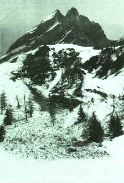
Avalanches,which are only erosion agents of secondary importance, normally begin in areas which have been shaped in the main by water erosion. Normally, gravity leads snow, at least in its initial period of movement, towards the natural hollow of the catchment area of a stream or torrent.
Downward view of a natural hollow, and also of the beginning of a transit area. Notice in the centre of the photograph the small natural banks which are still covered with patches of snow and debris carried by it.
If the lines of steepest gradient leading to this hollow are straight, then all avalanches reach it. They will thus be channelled into the gulley and will reach the end of it, depending, however, on the characteristics of the trajectory. For gulleys, and especially gorges, frequently manifest irregularities and bends, and it will depend on the nature of the avalanche and on the obstacle which deflects it, whether or not the avalanche breaks out from the natural channel created by water.
At low speed, avalanches are very sensitive to deflection by ground relief. But it should be borne in mind that avalanches reach their maximum speed within 50 to 80 metres.
For heavy snow this speed is seldom more than 50 to 60 km./hr. and the height of snow If motion is generally one and a half times the thickness of snow cover which produced it. For fresh snow ,-which produces airborne pow- avalanches the speeds reached are considerable (150 to 300 km./hr.) and the snow cloud can be 15, 20 or even 30 meters high.
The effectiveness of an obstacle depends on:
- the angle it forms with the direction of movement of snow; an obstacle which is perpendicular to the direction of flow is inferior often than not of no use in changing its direction, for it causes a build up of snow behind it and the avalanche will use it as if it were a ramp. It is estimated that the deflection will fail unless the angle formed by the deflected avalanche is less than 30 to 35°;
- the shape of the obstacle; a vertical wall deflects an avalanche much better than would one of the same profile protecting from the slope at an angle greater than the vertical, thereby creating the well known ramp effect;
- the length of the obstacle; friction against the face of the obstacle brakes the avalanche and tends to produce a partial deposit at the foot of the wall. This snow deposited there again plays the role of a ramp and facilitates the surmounting of the obstacle by future avalanches;
- the frequency of avalanches on the same site; if there is a tendency for an avalanche to recur several times in the same place during a winter, the deposit of the first avalanche in front of the obstacle will help avalanches which follow to overcome it;
- the height of the obstacle must be between 1.5 and four times the height of the avalanche, depending on the conditions of angle, shape and length outlined above, in order to deflect the avalanche effectively.
A careful study of these elements of size and of the situation will allow us to determine whether or not it is likely that an avalanche will use the bed of a stream completely. More often than not, the conclusion will be reached that there is more than one possible avalanche path for the same catchment area;
- the same channel as that used by water for heavy snow;
- one or more channels used by fast moving avalanches, especially airborne powder ones which may have been able to "jump" over obstacles here and there.
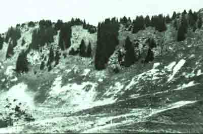
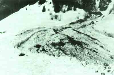
The passage of avalanches has above all an effect on forest vegetation. In practice we see a gap following the avalanche path. This gap will be visible for a long time whilst reforestation - initially with deciduous trees and then with conifers, which will nevertheless be much smaller than neighbouring trees - is taking place. For those who know what they are looking for, a slope may still show the traces of avalanches which may have taken place more than a century before.
An avalanche which "turns a corner" traces, by stripping the vegetation from the slope which deviated it, a characteristic and easily recognizable curve.
This denuding by avalanches can be followed by erosion of the classical kind, channelling, landslides, etc.
Even though an avalanche can destroy a complete area of forest we seldom find isolated trees destroyed. However, a young spruce may be deprived of its branches pointing uphill,deforming it in the same way as a tree clinging to a windswept ridge. But whereas wind withers up buds on the windward side, avalanches do not generally destroy every last whorl on a tree which retains a degree of suppleness.
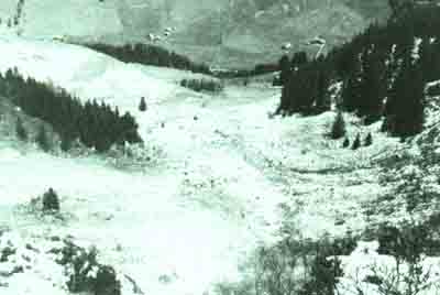
At the end of their course,avalanches do not deposit only snow. Very often they take with them all kinds of material pell-mell, torn from the starting area (fulldepth avalanches) or even from the gulley; as well as all kinds of vegetative debris.
Set into the snow at the base of the avalanche these blocks of material of all sizes settle gently as the snow melts and create what is known as an "avalanche cone".
The sides of these cones are very steep, for the material in them is not ordered in any way nor has it been rounded by rubbing against other material to any appreciable degree. These three characteristics are completely specific and can be recognized by geomorphologists without hesitation as avalanche deposits even after centuries.
Naturally, water erosion reshapes the avalanche cone if it is in the bed of a torrent. But where a gulley has been used by only avalanches (a fast moving avalanche which has "jumped over" an obstacle) the identification of the cone is important and very useful.
Vegetation is equally revealing; the avalanche debris, especially if it is a frequent occurrence, radically alters the vegetative period. The result, just as with the extra thick down-wind snow drifts, is a floral composition particular to the cone and often in stark contrast to that of neighbouring areas.
The forest also holds the traces of avalanche deposits. In the case of fast moving avalanches (airborne powder) we often find characteristic signs of serious damage in narrow valleys on the lower part of the slope opposite that on which the avalanche developed.
On a much finer scale, experts can detect in the zone of deposit, or in the transit area of avalanches, traces of their passage even if they are ancient; pieces of turf torn away by the snow are turned into the shape of a cigar and testify to the passage of an avalanche; similarly analogous rolls of turf formed around a twig can only be created by the slow inexorable glide of snow over the ground.
In regions for which development plans are on the drawing board, especially for the construction of new routes of communication or of new resorts for winter sports, one is often working in an area far from inhabited regions, and therefore information derived from direct observation is scanty and incomplete (see paragraph 1.4). In order to choose a route or an area for urbanization the planner needs documentation, the preparations for which cannot be too lengthy or costly, which will allow him to take stock of the avalanche danger for each of the options open to him.
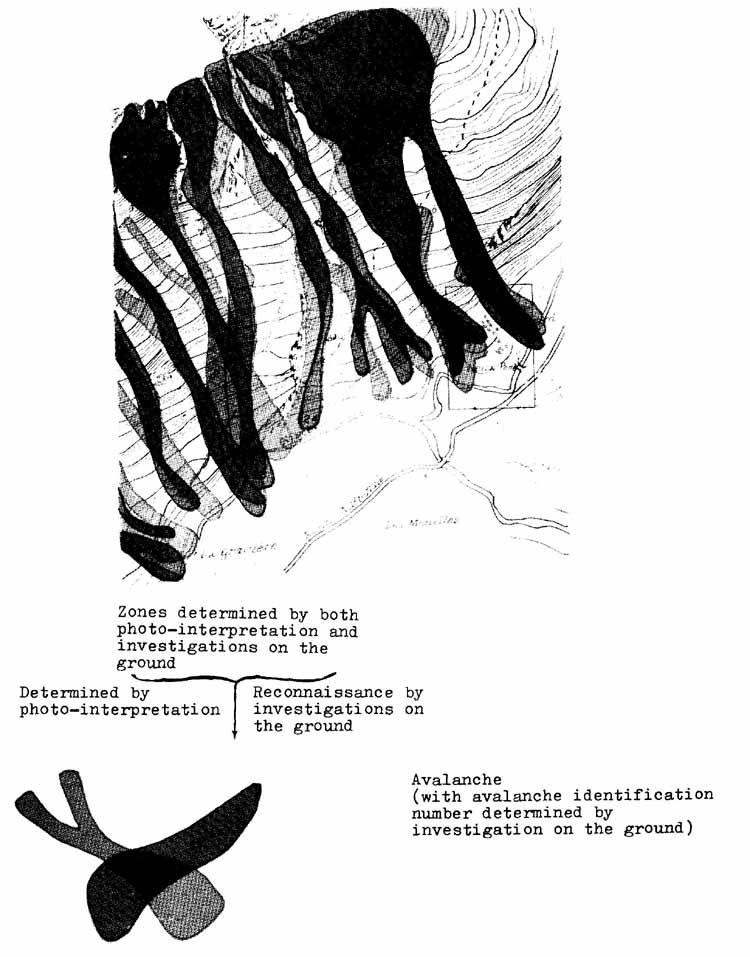
This is the aim of the "map for localization of likely avalanches" used primarily in France, which combines: direct observation during winter (point 1) and indirect observations in the absence of snow (point 2) described above.
Essentially this consists of the superimposition on the same map of two types of information.
The majority of the indices of relief, vegetation and of deposits at the base of gulleys described in paragraph 2 are visible on aerial photographs taken during the summer and interpreted in pairs with the aid of stereoscopic vision. a With some practice, and by comparing the photographs with direct observations in well known areas, experts in photograph interpretation can form a fairly reliable picture of likely areas of avalanche development.
The examination of several series of aerial surveys, when these are available, allows experts also to take count of the characteristic damage: disappearance of forests or buildings.
Lastly, close examination of aerial surveys by experts allows them to mark on a 1120 000 map those areas -which are assumed to have been covered by avalanches, even before on-site inspection.
Once this first presentation has been completed, the photo-interpreter visits the actual sites and proceeds with a search for physical signs not visible on the photographs. He should also carry out a systematic enquiry among the local inhabitants and archives and gain as much information as possible from traditional local sources both oral and written. The experience gained from the view, provided by aerial Photographs will be extremely valuable here, even if it is only to loosen wilfully reticent tongues when economic interests are at stake.
The results of the enquiry will be -transferred on to the map in a different colour over the photo interpretation.
The match will never be perfect, with either method giving more pessimistic results. Ground enquiry is of course much more accurate near inhabited areas, whereas the interpretation of photographs is of the same accuracy everywhere.
When an avalanche is known to recur throughout history a special number is given to it and a file is opened which will contain all kinds of documentation relevant to it: accounts of witnesses, maps, photographs and investigations concerning it, as was recommended in paragraph 1.3 of this chapter.
Cartography is of great value when information is missing on an area to be developed. But it only constitutes a working document of a provisional nature, and it only claims to detect approximately the most likely paths taken by avalanches in the past. This report does not constitute a forecast and has no predictive value.
Certainly a plan for urban development cannot rely exclusively on the information from such a map.
Despite all that we have said, avalanches remain a phenomenon about which too little is known to allow an exact prediction of their maximum extent to within a few meters, especially when dealing with the scale of urban development (1/10 000 to 1/5000). It would therefore be a scientific absurdity to trace on a map an area which is dangerous separated by a mere line from a safe area.
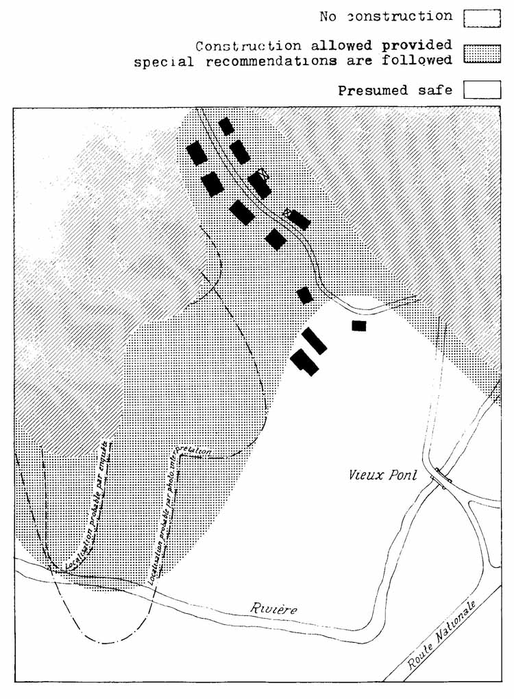
The only sensible step is to have a map with at least three colours representing:
- areas known to be dangerous,
- areas assumed to be safe,
- between these two an area of doubt where no building should take place unless certain special rules are followed.
This is the solution which urban planners have come up with in alpine areas where they needed to know whether it was safe or not to build in the mountains.
These maps are strictly limited to the needs of construction; they are therefore only drawn up for actually or potentially built-up areas. They therefore do not encompass the whole course of an avalanche, but only that part of the deposit zone which would intrude into the area. This is the essential difference between this kind of map and maps localizing likely avalanches.
Furthermore, whereas 1120 000 cartography only claims to constitute an objective determination of past events, the map of exposed areas aims to have predictive value, that is, taking account of possible or likely avalanches at all times.
The definition of the different zones is the most delicate part in the creation of these maps.
Normally, all areas where there is the certainty that there have been avalanches or that there could be avalanches capable of exerting a pressure of over three tons per square metre on a vertical obstacle, will be classified with the colour red ą/ (danger area).
White (for safe areas) will be used for those areas where damage caused by avalanches is regarded as virtually impossible.
As far as the areas of doubt are concerned, which are generally coloured blueą/, the range goes from areas where, on the one hand, an avalanche s been infrequent (with an interval of recurrence of over 20 to 30 years), and where such an avalanche would not be particularly significant (where a pressure of less than three tons per square metre on a vertical obstacle is anticipated); and on the other hand, where an avalanche would be significant but is extremely rare (with an interval of recurrence two or three times longer than the life expectancy of the construction: once every 200 to 300 years). It will be considered worthwhile building in these areas if there is the certainty that should exceptional snowfalls require it, and even if material damage cannot be avoided, at least loss of life can be avoided by evacuation.
ą/ The figures and photographs illustrating this manual have not been reproduced in colour, therefore the blue areas will be marked by dotted shading and the red areas with cross-hatching in Figure 9.
This combination of frequency and significance gives to the blue areas a somewhat ambiguous nature, for generally the least common avalanches are the most destructive, since they carry with them an enormous mass of snow.
For this reason the definition of the blue areas varies slightly from country to country.
Often it is necessary to distinguish different "degrees of blueness" in function of the pressures anticipated against a vertical surface (2 to 3 t/m˛ a 1 to 2 t/m˛ less than 1 t/m˛)
Defensive structures, whether stabilizing or diverting, create special situations. It would be unwise to classify such areas as safe (white) for this would constitute a wager on the effectiveness and, above all, on the durability of the structures. They are therefore classified as blue zones, and no constraints are placed on constructors other than that of keeping a constant check on the state of repair of the defence structures, and of being ready for evacuation in the case of catastrophic conditions.
From this variety of real life situations covered by the notion of the "blue zone", the problems of the nature of requirements to be made before construction is authorized become apparent. A list of the requirements will be presented in paragraph 4.3. Before hand, though, we should examine the methods used by the experts when drawing these maps.
This is a particularly delicate, difficult and perilous operation. Naturally some specialized knowledge is required, but above all it is a question of experience and great caution.
The same methods as those outlined for ground survey in paragraph 3.2 are used; the results are refined and extrapolated with a view to detecting the "variants" in-he usual routes of an avalanche.
The study will begin with a critical review of all the existing material in the "avalanche cadastre" and in the records of the "permanent observations" (see paragraph 1-3), as well as of the cartography of possible danger areas, of the aerial photographs and of the investigation files used to compile all this information.
Administrative archives, municipal and parish records, the accounts of travellers, etc., must all be consulted. Toponymy will also be a useful source of information. Sometimes the cadastre will be revealing: the areas of cultivation are small and long, following contour lines; the plots of land covered by avalanche deposits are normally used for pasture and tend to be bigger and to extend down-slope. A chapel may often mark the limits of an avalanche which claimed victims... All the physical signs listed in paragraph 2 will be examined in detail.
'The first enquiry will normally allow the boundary between the red and the blue zones to be drawn. But the determination of the blue/White boundary is much more difficult, especially for avalanches for which we have no precise past evidence put which we think could take place in the future.
Recourse will therefore have to be made to calculations for the zone of deposit, using the formulae derived from the theories of Voellmy.
The basis for calculations of avalanche deposits is composed of the series of formulae of Sommerhalder and Voellmy which are given at the end of Chapter V. These formulae allow the speed at various points of a flowing avalanche and the theoretical length of the deposit to be calculated. Given the speeds, the pressure against a vertical obstacle at each point can be estimated:
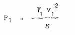
where :
However, these formulae should be applied with some circumspection especially in the choice of release conditions and parameters.
The estimation of maximum snow cover in both thickness and density is an extremely delicate matter for which we will use the guidelines (paragraph 1.3, Chapter II).
Simultaneous release in the whole of the possible starting zone must be assumed, then the trajectories from each basic cirque to the shared gulley must be broken down in order to determine the discharges which could either combine or follow each other through the gulley (see Chapter II, paragraph 2.2).
But the most difficult part is the fixing of the parameters of roughness between snow and ground E and of the internal coefficient of friction of the snow a q
The influence of E on the speed is very important, and that of q effects the length of the deposit area.
Studies in France and Canada of artificially released avalanches have led to the adoption of 1 400 m./m. for the coefficient a in surface avalanches (snow on snow), which is greatly in excess of the values generally used for full-depth avalanches: 400-800 m./m.
The same experiments have shown that the internal coefficient of friction varies with the speed of the avalanche. Thus:
![]()
The results in relation to classical data show that the fastest avalanches over the steepest sections slow down and settle much more quickly.
The pressure exerted by the avalanche on arrival is not proportional to the square of the speed, and is only a force equal to 4/3 of this. This leads to further uncertainty in the formula to be chosen for calculating the areas of the blue zones.
Clearly theorists are a long way from agreeing on these formulae which must therefore be used with caution, taking care to compare the results obtained from them with what good sense and experience would suggest.
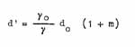
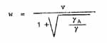
Airborne powder avalanches (powder snow in the form of an aerosol) have a very different dynamic to flowing avalanches. The following formulae to describe them are proposed by Voellmy:
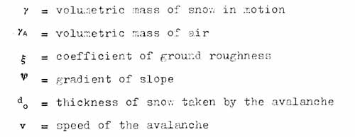
The volumetric mass of the fluid is a Function of the slope by:
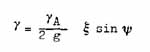
The avalanche develops over a height:
where m is a variable ranging from zero then the avalanche is moving over a hard layer of snow (which is little influenced by movement above it a to a value of 1 when everything lying under the avalanche is taken up into the turbulent movement.
The velocity v given by the theory and simplified by neglecting cos Y is the value of a velocity of mass
The speed of the front w is related to it by
'The high pressures -and the effect classically known as "blast" are due to the fact that air in front of the avalanche is also set in motion to a considerable extent (this is not the case with "flowing" avalanches); also the relatively low speed of the front of the avalanche compared to the speeds within it produces the phenomenon of "shock waves".
Voellmy gives us the following formulae for the pressure exerted the front of the avalanche or air pushed in front of it -
![]()
for increased high pressure clue to waves of compression -
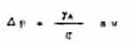
where a is the speed of sound through air: 340 m./sec.
Arrest of the avalanche:
The density of avalanches decreases with the gradient and their thickness increases. An airborne powder avalanche takes a long time to stop on flat, bare ground. Only large obstacles will be able to absorb some of its energy, and thus slow it down "deflate" it and finally stop it.
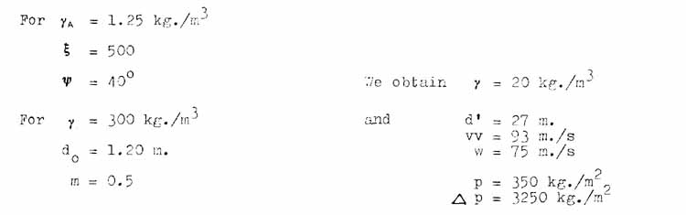
Numerical application:
However, experience on the ground confirmed by studies on the flow of dense substances on steep slopes which constitute a good simulation of airborne powder avalanches have shown that contrary to Voellmy, the speed of an airborne avalanche is practically independent of the gradient but is almost entirely dependent on the height of snow set in motion.
If airborne powder avalanches are expected, the red or blue zones cannot be limited before a steep opposite slope, for such avalanches hardly spread out and continue in a straight line.
Thus for airborne powder avalanches, as well as for flowing avalanches, we are still a long way from a rigorous and reliable method for determining the zones which urban planners are demanding with growing insistence. The experience of specialists must always be called upon, for they have an arsenal of methods for differentiating the subtleties of the constraints in blue areas.
Throughout the blue zone it is vital that the police should be prepared to evacuate the area in case of extreme danger, or in the case of access to the area being dangerous, confining the inhabitants to their homes.
If the blue area is protected by a network of stabilizing structures, or by structures designed to deviate an avalanche, or by a forest, it is essential that the state of repair and the efficacy of these defences should be constantly checked so that in the event of their disappearance (for example, by fire, felling or destruction by parasites of the forest) police measures could be taken if necessary culminating in evacuation.
In the realm of architecture a wide variety of measures can be taken; the zoning gives an indication of the likely pressures which would be exerted on the side of buildings exposed to avalanches. All openings (doors, etc.) on the exposed side must be forbidden. Roofs can be reinforced (concrete slabs) and the overhang of eaves formed these on the exposed side can, be prescribed. A maximum roof angle in the direction of the avalanche can be determined; the number of floors can be limited blocks of flats banned; each house should be conceived of as a structure deviating avalanches (exposed wall in the shape of a splitting wedge).
It is advantageous for houses -to protect each other, and not to deflect an avalanche on to a neighbouring one. Plans should therefore be drawn up for aligning houses in the direction of an avalanche leaving, at the beginning 30 to 50 metres free between the lines of construction. In this way a single splitting wedge would protect several buildings.
In certain areas all constructions will be banned until defence structures have been completed. This will be the case with red areas which will become blue when the defences have been completed.
Maximum extent of avalanches known at the date of publication - 1972
Town planning document defining areas where:
![]()
![]()
![]()