![]()
![]()
![]()
Existing forests in upper watersheds produce a number of substantial benefits which should not lightly be discarded, as increasing amounts of forest come under planned or unplanned forest conversion to agriculture and grazing. Foresters and others, however, must not be guilty of exaggerating those benefits or claiming spurious benefits because they want to weight the balance in favor of retention of forests. For instance, forest benefits do not extend to creating rain nor to preventing major disastrous floods in the lower reaches of large river systems. They do, assuredly, in undisturbed form, provide the greatest vegetative protection against erosion and mass movement, yield the least sediment, and usually reduce local stream peak flows from storms of shorter duration and lower intensity which occur with a high frequence (i.e., not those that occur perhaps once in 30 years or less nor for the annual torrential monsoon rains when there is total soil saturations for long periods of time). In certain physiographic situations where frequent cloud cover occurs at upper elevations, forests can "capture" moisture by condensation and add it to the watershed system as increased "effective" precipitation. These situations are the well-known "cloud" or "wet dwarf" forests of the tropics. In addition, natural undisturbed forests are habitat for a rich array of indigenous fauna and flora (other than trees) that constitutes not only a national but a global patrimony. The genetic bank represented by natural tropical forests may be one of their principal values.
These forests may be harvested for nonwood forests products such as rattans, fruits and nuts (if done in moderation) without sacrificing any of the benefits of importance in watershed management. Tribal forest dwellers using such produce at the hunter-gather level are not usually of concern in terms of soil and water conservation. These forests may also provide opportunities for scientific research, nature study, and tourism without decreasing their hydrologic and soil conserving functions, while clothing the landscape in esthetically pleasing fashion.
However, as the intensity of forest modification increases to include such activities as stable shifting agriculture, light forest grazing and wood product harvesting, some of the protective watershed functions are at risk unless high standards of performance are induced or enforced. The paper discusses some of the guidelines and methods of maintaining a high degree of hydrological and erosional safety under such uses. Of particular importance for minimizing erosion and sediment yield from a watershed are: the maintenance of undisturbed streamside buffer strips; maintenance of continuous tree roots on landslip-prone sites; care in location, design and maintenance of roads for harvesting; protection from fire; maintenance of the litter layer and understory vegetation (including continuous grass cover if the forest comes under a light grazing use -- a situation extremely difficult to achieve where pressures of humans and livestock are high). It is suggested that with high performance standards, direct wood product harvest and stable shifting agriculture do not significantly increase the incidence nor severity of major catastrophic lower basin floods, and may result in greater yield of water from the watershed through reduction in evapotranspiration losses.
Conversely, there are many watershed benefits to be garnered from putting forests on denuded lands (forestation) or in introducing trees or groups of trees into agricultural or grazing systems (agroforestry or sylvopastoral systems). It is cautioned, however, that these benefits in soil and water protection do not occur automatically by virtue of having trees on the land. For instance, there can still be erosion and resulting sediment in an agroforestry system, if the crop cultivation is not carried out with good soil conservation management practices, including such things as terraces in steepland and maintenance of organic litter or live vegetation on the otherwise bare soil. Even under reforested or afforested plantations, erosion can occur on steep slopes if litter cover or understory vegetation are not present (perhaps through removal, or if harvesting the plantation products is not done with attention to watershed values).
There are many excellent reasons for maintaining forests or for planting forests or trees on watershed lands. These relate not only to the direct product benefits, to biological diversity conservation, and to landscape aesthetics, but to a bundle of very practical, though difficult to quantify, benefits having to do with erosion and hydrologic safety in a watershed management context. It is important, however, for foresters and other watershed professionals not to make unrealizable claims of mythical or questionable soil and water benefits.
A wide range of claims have been made about the miraculous benefits of trees, whether in rows, groves or forests. It is alleged that they can stop floods, make rain, provide fuelwood, yield fodder, produce resins (or saps), provide food, renew springs and wells, prevent erosion, shelter and feed wildlife, keep sediment out of rivers, lakes and reservoirs, release more water during the dry season, enhance landscape beauty, supply commercial wood products such as timber and biomass for energy, and protect gene-pools of biotic diversity. When planted in conjunction with annual crops, trees are alleged to provide beneficial litter, to ameliorate microclimate, to pump up nutrients, and to fix nitrogen, thereby enhancing crop yields. Forests are a home for some primitive tribal people.
"Miracle trees" indeed, and as a forester I am happy to be associated with their protection and management, or their establishment on new or formerly forested areas. It is true that rows of trees (as in shelterbelts or lines in alley cropping systems), groves of trees (as in some agroforestry systems), or closed blocks or groups of trees (as in plantations or natural forests) can produce many, but not all of these benefits. Even those benefits that they can produce are not necessarily produced simultaneously, sequentially, or under all circumstances, although much popular literature would have you believe that this is the case.
Many foresters have tended to acquiesce, by their silence, when such impressive lists of benefits were made for tree planting or maintaining forests. Small wonder it is for foresters have had to fight to get across to the planning table when forest land allocation decisions were being made by economic development planners. They have had to struggle against powerful peasant pressures for forest land occupancy, and against wealthy, politically strong cattle barons and estate owners wanting to convert more forest land and "privatize" it. Foresters have had to labor hard to restore tree cover to denuded and degraded lands. Widespread popular support based on the many benefits of forests and trees has been necessary, and from as many publics or clients as possible. Therefore, if the benefits are somewhat exaggerated, didn't the end (forest clad uplands, for instance) justify the means?
As a forester, I suggest that we had better forego the "trees-area-panacea-for-all-land-and-water-ills" stance, and become more realistic in proclaiming what forests will and will not do in providing all of the aforementioned benefits. If we do not, we face real risks from disappointed publics and clients in the future. We must maintain our credibility by clarifying what benefits can be legitimately claimed, under what circumstances, and with what trade-offs among other products or services. In this presentation, I will deal only with some of the real versus touted soil and water benefits resulting from watershed management and rehabilitation. I contend that only those benefits which can be realized should be accepted as a mandate from society in watershed forestry programs.
It is being advocated that watershed forests be protected, not only from conversion to agriculture or grazing, but from wood harvesting, because such actions will result in decreased rainfall, causing droughts and creating deserts. Much of the clamor concerns not tropical dry forests, or woodland, but tropical rainforest.
Popular writing about the effects logging has on rainfall in tropical rainforests comes from a wide range of sources. The World Wildlife Fund/IUCN Tropical Forest Campaign was initiated in October 1982 in Bali, Indonesia. It suggested that following logging, the "land of green gold" is turned into "useless desert" and that "take away the trees and you get withering drought in the dry season" (WWF/IUCN, 1982). Suggestive of the same thinking was the title of a fine and influential book, "Amazon Jungle: Green Hell to Red Desert?" Woodland and Irwin, 1975). The leader of the Tree Hugging Movement (Chipko) in India has claimed that cutting of the forest results in drought (World Water, 1981). An article entitled, "The Desertification of Asia," claimed that "deserts can develop with great speed even in the heart of a tropical jungle" (Sharp and Sharp, 1982).
In these cases there may be some slippery semantics in the words "desert" and "drought," but the popular mental picture conjured up coincides with a dictionary definition that a desert is "arid land with insufficient precipitation to permit plant growth," and that a drought is "lack of precipitation or moisture." It is difficult to comprehend how a tropical rain forest area receiving upwards of 1,800 mm/year of rain can be converted into a desert by logging. Even a tropical seasonal forest or woodland does not change to desert after tree harvesting. It is true, that logging followed by fire and conversion to abusive agriculture or grazing can result in degraded, strongly eroded wasteland, but deserts do not follow logging.
What does research have to offer on this topic? Some Russian work, cited and summarized by Shpak (1968) showed approximately 10 percent more rain in forest areas as opposed to adjacent open areas. Shpak goes on, however, to point out precipitation measuring problems that invariably allow forest gages to catch more rain. He concludes that "the considerable increase (found by some authors) ... is usually overstated ... the problem of the effect of forest on precipitation remains open at present." An early study in the United States following large scale "deforestation" by smelter fume injury, showed small (14 percent) but significantly greater precipitation in the forest area compared with the denuded area (Hursch, 1948). A subsequent analysis of those experimental procedures by Lee (1978), however, indicated that when catch differences are accounted for (mainly from wind effects), the differences were less than 0.5 percent. In the tropics, Bernard (1953) found no evidence of any influence of forests on rainfall for the one million square kilometer Central Congo Basin. He speculated, however, that forest clearing, by increasing the heat reflectance might introduce some instability into weather patterns.
Recently, however, in the Amazon Basin it has been shown that this large forested area with its unique hydrometeorology regenerates some of its own rain (Salati et al., 1979). It is speculated that large scale and permanent deforestation (not just logging) could reduce rainfall in downwind parts of the basin (Salati et al., 1983; Salati and Vose, 1984). The scientific community has not reached a consensus on this speculation and modeling studies have given somewhat conflicting results. However, it would seem prudent to consider the possibility of reduced rainfall in considering future development of the Amazon.
For most hydrometeorological situations in Asia and the Pacific, it is more likely that Pereira's (1973) summary is still valid: "There is no corresponding evidence as to any effects of forests on the occurrence of rainfall." Although there are many compelling, scientifically sound, and philosophically imperative reasons for trying to preserve a large amount of the remaining primary tropical rain forest, the fear of large reductions in rainfall following cutting of forests is not one of them. As a matter of fact the interception of rainfall (or snow) by a forest canopy, and the subsequent evaporation of a portion of this (called "interception loss") means that the effective precipitation reaching the ground is less than the actual precipitation. Interception losses are generally greater for forests than for any other vegetation type an land use.
There is one exception. In certain physiographic situations, for example in coastal fog belts or at high elevations characterized by frequent or persistent clouds, forest can "capture'' and condense atmospheric moisture. This so-called "occult" precipitation is added to the effective moisture received by the area and may represent a substantial percentage of the total. For example, in Hawaii occult precipitation represented an increase of 760 mm above a nonforested 2,600 mm of rainfall (Ekern, 1964). Cutting down these cloud or fog forests results in a loss of this precipitation, though it is restored as the forest regrows. If the area is converted to another use, however, most of this moisture is removed from the water budget of the watershed, including water outflow from the immediate watershed (Zadroga, 1981). Keeping the cloud forest and fog forests intact makes good hydrologic sense in watershed management as a source of additional water for downstream agricultural, domestic and industrial use.
Conversely, no increases in gross precipitation have been shown following programs of reforestation or afforestation in formerly open lands. And because of increased interception losses, there may even be a decrease in effective precipitation reaching the ground. Such activity is an important part of watershed rehabilitation, but not for any alleged benefits in making rain. In persistent cloud situations, however, planting belts of trees or forests can capture occult moisture, and are therefore benefical watershed rehabilitation practices which do increase water availability (Hamilton, 1983).
Popular wisdom insists that planting trees will prevent erosion and that removing trees, per se, results in drastic erosion leading to land degradation. Trees, and particularly trees in forest stands do indeed reduce the amount of erosion, and conventional wisdom does coincide with proven effects. Soil erosion under dense natural humid and seasonally humid forest is usually less than one ton per hectare per year (UNESCO/ UNEP/FAO, 1978). However, substantial surface erosion can occur in undisturbed forest (Lal, 1983), as can landslips and debris avalanches on forested unstable slopes (Lin, 1984). Nonetheless, the undisturbed forest is excellent watershed cover from the erosion standpoint, but it is more appropriate to speak of forests as having low erosion rather than no erosion; and when putting forest back on land to talk about erosion reduction, rather than prevention. To be more precise it is also necessary to separate three classes of erosion: (a) surface (sheetwash and rills), (b) gully, and (c) mass wasting (landslips, slumps, debris flows, etc.).
Surface Erosion
Surface erosion under humid tropical primary forest is generally more severe than in humid temperate forests, because of more frequent and intense rains and less litter and ground vegetation on the soil surface (Birot, 1968). In dry or seasonal forest, rates of erosion are probably comparable between tropic and temperate zones, depending on rainfall patterns. If understory vegetation in forests is not overgrazed nor the litter burned, erosion rates are still very low.
Moreover, simply putting trees or forests back on the land does not eliminate surface erosion. Bell (1973) reported significant erosion problems in pure Tectona.grandis plantations in Trinidad, and similar problems have been reported in El Salvador and Thailand (Kunkle, 1983) and in Java (Coster, 1938) where there is no understory vegetation and/or litter is removed. Brunig et al. (1975) reported annual erosion rates on moderate slopes for undisturbed natural forest, teak plantation widely spaced with mixed understory, and dense teak plantations with no understory as 0.2-10, 2-10, and 20-160 tons/ha, respectively.
Advocates sometimes talk about the benefits of having a tree canopy interposed between the falling rain and the bare soil to reduce splash erosion (detachment of particles by raindrop impact, and then movement). Actually, splash erosion can be greater under trees because drop sizes are larger. Coalescing raindrops on large-leaved species (such as teak), falling from a high canopy may be more damaging to the soil than the rain itself. For instance, Albizzia falcataria with canopy height of 20 m yielded raindrops with an erosive energy 102 percent of rain in the open, but the Anthocephalus chinensis with its large leaves at only 10 m canopy height, this figure was 147 percent (Lembaga Ekologi, 1980). Repeated results of surface erosion studies in forests have shown that it is the leaf litter and low understory that impart erosion protection (for example, Wiersum, in press). If these are removed for fodder and/or fuel, or if livestock are turned in to graze, the presence of trees will not minimize surface erosion on slopes. Wiersum (1984) has synthesized much of the research literature on erosion under various forest and tree crop systems and presented an interesting table of averages (lumping all data, even though derived from different slopes and soils -- Table 1). Note that as soon as the litter is removed by cultivation or weeding or burning, the erosion rate increases substantially.
| Minimal | Median | Maximal | |
| Multistoried tree gardens (4/4)* | 0.01 | 0.06 | 0.14 |
| Natural forests (18/27) | 0.03 | 0.30 | 6.16 |
| Shifting cultivation, fallow period (6/14) | 0.05 | 0.15 | 7.40 |
| Forest plantations, undisturbed (14/20) | 0.02 | 0.58 | 6.20 |
| Tree crops with cover crop/mulch (9/17) | 0.10 | 0.75 | 5.60 |
| Shifting cultivation, cropping period (7/22) | 0.40 | 2.78 | 70.05 |
| Taungya cultivation (2/6) | 0.63 | 5.23 | 17.37 |
| Tree crops, clean-weeded (10/17) | 1.20 | 47.60 | 182.90 |
| Forest plantations, burned/litter removed (7/7) | 5.92 | 53.40 | 104.80 |
*(x/y) x = no. locations. y = no. treatments or observations.
From Wiersum (1984).
Introducing trees into a cropping system, whether shifting agriculture or sedentary agriculture, has been suggested as a desirable watershed management practice. It should be recognized that from the surface erosion standpoint, the trees will only give reductions if the cropping practices maintain much leaf litter and vegetative cover on the soil. Good soil conservation farming (or grazing) must prevail if an agroforestry system is to claim erosion reduction benefits in a watershed strategy.
Another aspect concerning trees and erosion merits some attention. A hazard arises in connection with any soil disturbance associated with preparing the site for reforestation or afforestation, and with any subsequent cultivation to reduce competition in the early establishment phase. in the drier parts of tropical Asia and the Pacific, competing vegetation may not be a concern and thus the hand-planting and lack of subsequent cultivation bring no erosion problems. But experience in moist areas of Queensland and Nigeria has shown that site preparation pays off in terms of increased survival and growth. Even in the Fiji dry zone, Bell and Evo (1982) suggest that the Fiji Pine Commission employ cultivation prior to and during the establishment of eucalyptus energy plantations. Cassells in Australia is currently developing a set of planting site preparation guidelines for tropical Queensland based on erosion studies conducted since 1974 (Cassells et al., 1982). Contour row-ploughing has been found most satisfactory in erodible soils (Cassells, pers. com.). Fast growing, nitrogen fixing trees would seem to offer advantages in requiring little weeding because of growth rate, and encouraging protective ground cover due to N-fixation.
An important part of watershed planning and management involves identifying areas of high surface erosion hazard. The hazard is a function of rainfall erosivity, slope (gradient and length), soil erodibility and the amount of vegetative protection on the surface. Megahan and King (in press) have presented the various methods of predicting erosion, including use of the modified Universal Soil Loss Equation (Dissmeyer and Foster, 1980). High erosion hazard forest lands might be termed "critical" and require either total protection or special practices for wood extraction. If these high hazard areas are already cleared lands under a use that cannot be meliorated by soil conservation measures (e.g., grazing control, installation of terraces), then they might well be closed to such uses and reforested or afforested as a rehabilitation measure.
Gully Erosion
Gully erosion in existing forest usually develops from surface erosion, applies to minimizing the development of gullies. Once gullies have developed, through some inappropriate land use practice, their stabilization in watershed rehabilitation is important, but difficult. In an advanced state, gullies are usually undergoing complex erosional processes of headcutting, slumping, and surface erosion. The important remedial action is to protect the surface with vegetation, litter, and root systems networks as rapidly as possible, and to alter the flow of water away from gully headwall. Trees have a major role to play here, especially fastgrowing species, though they may be combined with grasses, herbaceous material or shrubs. Gully stabilization may even require reshaping or minor structural measures especially at the gully heads. Gully stabilization and rehabilitation with productive vegetation is a complex technical activity, and may require more than forestry expertise to do well and permanently, especially in nonhumid areas with a rainfall regime of high intensity storms and difficulties in getting vegetation established due to lack of soil moisture. Weber and Hoskins (1983) presented various structural methods that can be carried out manually with local materials in Africa, and Crouch et al. (1984) have documented techniques using small but more sophisticated weirs for gully control in Australia.
Mass Erosion
In watershed planning and management, slopes which are prone to mass wasting merit special attention as "critical areas." Megahan and King (in press) have made suggestions for identifying areas with high hazard for mass erosion. Land use allocations and management policies for landslide prone areas should be based on the degree of climatic, topographic and edaphic hazard. In the case of deep-seated slides this is indicated simply by whether or not slides occur in the area (i.e., "hazardous" or "not hazardous"). For shallow slides, the degree of hazard can be assessed, and stratified, for different levels of care. The criteria for the hazard rating are based on storm rainfall intensity and duration, and on slope gradient and shape. Megahan and King summarized the literature and suggested that shallow landslips are limited to slopes greater than 45 to 55 percent, with a maximum frequency of occurrence at about 70 percent. Landslips also are correlated with slope concavities and convergences that concentrate water. Phillips and Pearce (in press) have illustrated terrain stability zoning in New Zealand using somewhat different criteria, more related to geologic and geomorphic factors.
Sites that are prone to shallow landslips, are given greater stability by tree roots. These roots impart shear strength to the soil. Loss of this shear strength following tree cutting or tree removal and subsequent greater incidence of slope failures has been reported by O'Loughlin and Ziemer (1982). By establishing plantations on erosion prone sites, O'Loughlin (in press) documented that between 5 and 10 years after establishment young Pinus radiata, root development began to increase substantially the slope resistance to shallow failures. However, he found that reforestation was not generally effective in containing retrogressive slumping around headwalls of actively eroding gullies and large landslides.
If forests are to be harvested on areas prone to shallow slides, cutting alone, even
without the disturbance associated with wood removal, can alter the slope stability. Where
stumps coppice, so that the root systems remain alive, there is no problem. Thus, in
short-rotation fuelwood plantations of fast-growing coppicing species, the root systems
would continue their meliorating function. Where this is not the case, loss of soil shear
strength depends on the rate of root decay following cutting, compared to the growth of
new roots from uncut trees or forest reproduction. Because of this, in the northern Rocky
Mountains of the United States, in Japan, and in Alaska, post cutting landslide hazards
did not peak until from 2 to 10 years after logging (Megahan et al., 1978; Nakano, 1971;
Bishop and Stevens, 1964). If the forest is cleared for conversion to grazing or cropping,
the root systems of the grasses and annual crops provide much less shear strength compared
to forest, and therefore may accelerate landslide activity (Trustrum et al., in press).
Where land is already cleared and under some kind of cropping or grazing regime, the introduction of trees in an agroforestry land use system can improve the stability of areas prone to shallow slips. Rows of trees on the contour with alley cropping or grazing would appear to offer the best arrangement in utilizing both the strength of tree roots, and the "fence" function of trapping any surface wash from uphill, thus gradually creating a series of natural terraces. A good example of such a practice, developed spontaneously over time by traditional hill people may be found in Cebu in the Philippines (Vergara, pers. com.). Here on slopes ranging up to 80 percent, rows of Leucaena leucocephala have been established as producers of stemwood for fuel, leaves for inter-row mulch and soil amendment, and nitrogen through fixation by this fast-growing legume. Soil shear strength can also be imparted by roots of many fruit trees that may be used in an agroforestry system.
While Swanston (1981) stated that deep-seated landslides are only slightly, if at all, influenced by vegetation, O'Loughlin (1984) suggested that there may be some beneficial effects. However, road construction involving embankments, excavation, and changes in slope drainage often have dramatic impact on such deep-seated mass movements. Areas prone to such mass erosion should be avoided in planning and road networks in watersheds. If forested, these areas should be maintained in forest, for such vegetation tends to involve less intensive use and disturbance even under the heavy pressure in developing countries. Any forest harvesting in the sensitive areas must be done with extreme care. If timber is sufficiently valuable, logging might be accomplished by helicopter or balloon, though there is little or no experience with these "high-tech" methods in developing countries. If fuelwood is required, transporting should be done by hand or by animal power without road construction. Minor forest product harvesting would appear acceptable. In many cases these steep areas might well be allocated to forest preserve status or to park status, if there are appropriate national patrimony values.
Human Activity
The undisturbed, closed forest is unquestionably the best situation in watershed cover, for this permits the canopies, litter, soil organic layer and root systems to have the greatest roles in minimizing erosion of all kinds. A hierarchy of human uses can be considered, each with an increasing order of disturbance to this protective function. These might range from scientific study and wilderness recreation, through minor forest product harvesting, to logging and shifting cultivation. As the uses of a particular forest site increase the area's susceptibility to erosion, a greater degree of land use control would need to be instituted. For instance, performance standards (logging guidelines)have been developed for timber harvesting that are universally applicable, with specific local modifications (for instance Gilmour, 1977a; Megahan and Schweithelm, 1983). These minimize, but do not eliminate the disturbance effects on erosion, and are effective in permitting this kind of use on all but the very high hazard areas. However, if politically, culturally or economically such control is impossible, then such a human activity would have to be confined to low erosion hazard sites, and prohibited on sites with intermediate or high erosion hazard.
Other land uses, such as grazing or agriculture may also have little erosion on low to medium hazard areas, if adequate soil conservation and animal management performance standards are instituted * The stable, terraced rice paddies on steep slopes in several parts of South and Southeast Asia are testimony to low erosion under intensive agricultural use. Unfortunately, however, much hill land under agriculture in the region is unravelling testimony to the lack of good soil and water conservation. It should also be remembered that the conversion process itself is almost invariably accompanied by serious erosion if the land is sloping. The excellent studies at the International Institute of Tropical Agriculture at Ibadan by Lal and his co-workers have documented the soil loss risks under various methods of land clearing (see, for instance, Lal, 1981). Thus, even though a new use such as rubber plantations with adequate soil conservation, can replace forest with only slightly more erosion occurring once the new use is in place, a watershed planner must consider the erosion associated with the land clearing, and the subsequent erosion every time the rubber crop is replaced.
In the tropical dry forest, or even seasonal forest, fire can be a factor in watershed management. Fire is often used as a land management tool by graziers or those practicing shifting cultivation. Fire can "escape" into the adjacent forest, or be deliberately introduced to secure a usufructuary or tenurial advantage. The major watershed effect of fire is in the removal of the litter and low vegetative cover that protects the soil surface from surface erosion (Hamilton, 1983). Very hot and prolonged fires may also reduce the organic content of the soil, and reduce structural stability. Such a fire may also kill the trees completely, thus initiating loss of root strength. Frequent fires may keep a forested site in a continually eroding condition. In Pakistan, frequently burned stands of Pinus roxburghii were reported to exhibit as much erosion as unterraced croplands (Raeder-Roitzsch and Masur, 1968). in planted forests, particularly those consisting of conifers, eucalypts or Casuarina, fire is a major hazard. If the program of watershed rehabilitation involves reforestation or afforestation, there may be local customary users of the land who would prefer not to find trees occupying the land. Their support must be obtained before commencing a watershed tree planting program, or fire may be a continual problem.
Summary - Forests and Erosion
One mandate for forests that can be accepted by foresters and land use planners is that of erosion reduction. In this connection it must be recognized that the high degree of soil protection derives from three major characteristics of forests and groups of trees. The first is the development and maintenance of litter and understory vegetation to give soil surface protection from splash, sheet, and rill erosion. The second is the additional shear strength afforded by tree roots in areas prone to mass erosion. This is perhaps augmented by the high evapotranspiration rates that reduce the frequency of soil water saturation conditions leading to slope failures. The third is that forests have traditionally been susceptible to only low intensity uses, e.g., minor forest product harvesting, long-fallow shifting agriculture, and fuelwood or timber harvesting at long intervals. This intensity of use pattern is changing. Long-fallow, stable, shifting agriculture is being rapidly replaced in much of the tropics with unstable, cash crop, shifting agriculture, accompanied by serious erosion and productivity degradation. In cooler steeplands of the tropical world, fodder lopping and fuelwood cutting have become so heavy that they have become, in essence, conversion activities accompanied with fire, grazing and sometimes cropping even on public forest land. Mechanized logging techniques using heavy equipment are also commonplace in timber harvesting, and they employ dense road and track networks plus log landings occupying from 16 percent of Malaysian logging sites (Burgess, 1973) to 25 percent of sites in Australia (Gilmour et al., 1982). Moreover the increasing wood fiber and energy demand is leading to the short-rotation, "all and any tree" type of harvesting. This may result in heavy equipment returning to the same area on a short cycle. Such a situation can no longer be characterized as lowintensity, and will require great care by foresters in assuring effective soil and water conservation practices.
FORESTS AND SEDIMENT
Increased sediment in streams, lakes and reservoirs can: harm or kill valuable aquatic life (including fisheries and mangrove resources); impair water quality for drinking, other domestic uses, and industrial processes; reduce reservoir capacity for important flood, hydropower, or irrigation storages; shorten the useful life of hydroelectric turbines and water pumps; interfere with navigation; and degrade river channels, thus aggravating flooding. Most of these unwanted effects of sediment are in the downstream portions of watersheds where reside usually the greater part of the wealth, political power and population of a drainage basin. The link between upstream land erosion and downstream sediment problems has been recognized by these affected people, and there are increasing levels of action being called for to stop or reduce harmful sedimentation through better upland watershed management. Attention is being currently given to benefit/cost assessments of the erosion/sedimentation interaction in major water resource development projects (see, for instance, Fleming, 1982, and the papers in this symposium by Brooks and Gregersen and by Hufschmidt).
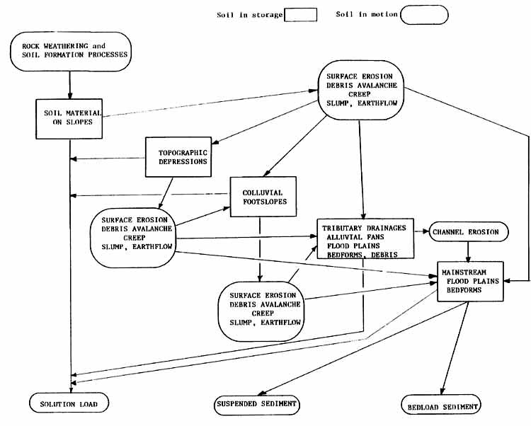
It has been claimed that the presence of forests on an area eliminates stream sediment problems (waters flow crystal clear) and that restoring forest cover will completely rectify serious sediment problems in a watershed. The presence of forests, by their effects in reducing erosion, does indeed have an important beneficial impact on sediment output. Streambank erosion and streambed degradation are, however, normal processes, and much sediment that causes mischief derives from these sources. Nonetheless, land erosion contributes substantially to sediment loading of streams. The erosion/sedimentation processes are illustrated in Figure 1. The effects of forests, forest uses, and reforestation on erosion rates have been discussed in Section 2 of this paper.
Hardjono (1980) reported on reforestation benefits in Indonesia, from subwatersheds planted with Pinus merkusii, Tectona grandis, Swietenia macrophyla, and Eucalyptus alba. He found sediment yield from forested areas to be three times lower than an agricultural watershed. This effect has been discussed in the previous section, and pertains to both the role of maintaining forests on a site or of planting trees on erosion-prone sites. Even introducing trees into grazing or cropping land in a well-managed agroforestry system can have important sediment reduction effects (Hamilton, 1983). Having forests downslope of an area experiencing surface erosion can also trap the sediment and store it either temporarily or permanently. Under long-fallow, patchwork mosaic, shifting agricultural systems, there is usually brushland or forest downslope adjacent to the cropped area which may be experiencing some surface erosion (Hamilton, 1983). It is this feature that causes traditional stable shifting cultivation systems to be relatively benign as far as sediment in streams is concerned.
This downslope, sediment trapping effect highlights the importance of streamside buffer strips of undisturbed forest. The effectiveness of streamside buffers has been documented for tropical Australia by Gilmour et al. (1982) on sites where substantial overland flow occurs due to an impeding layer at about 20 cm. This also has been well illustrated in work by Graynoth (1979) in New Zealand, who reported mean suspended sediment concentrations for four forest watersheds that had received the following treatments: control (8 mg/l), logged with no protection (213 mg/l), logged with no protection (188 mg/l) ,and logged with riparian protection (27 mg/l), Observations of serious stream sediment problems in South Africa following logging led Bosch and Hewlett (1980) to develop strong recommendations and planning design aids for what they termed "streamside management zones." These riparian forest areas can also reduce streambank erosion by helping to stabilize banks.
The trapping and storing process suggests another major problem having to do with watershed rehabilitation measures to reduce sediment. It is extremely difficult to predict when the reduction of erosion by a practice such as reforestation, will show up as less sediment in a reservoir -- capturing a benefit to which money value can be assigned. Megahan (1981) has described the storage in the erosion/sedimentation processes and depicted them as in Figure 1. The sediment showing up in a stream after one storm event may have come from temporary storage where eroded soil over a number of years has been deposited. Thus the full effect of soil erosion reduction measures through a practice such as reforestation, may not show up for many years, even decades, in terms of a realizable downstream benefit in sediment reduction.
Nonetheless, it has been demonstrated that appropriate forest land use practices can reduce sediment yields in streams emanating from the area treated. Conversely, careless forest land uses increase sediment discharge from the immediate catchment. Logging of a tropical catchment in North Queensland, Australia, produced a two- to threefold increase in suspended sediment load at high flows. Sediment load increased from about 180 ppm before logging to about 320 ppm during the first year after logging, and to about 520 ppm during the second year after logging (Gilmour, 1977b). The increase in the second year was attributed to differing rainfall characteristics, for ordinarily revegetation regrowth would be expected to gradually reduce the sediment yield. At another North Queensland site involving heavy logging of virgin tropical rainforest, during high intensity rains the peak concentrations at sampling stations below the logging area increased six- to twelvefold (Gilmour, 1971). The sediment derived from streams flowing through undisturbed forest was largely organic, in contrast with the dominantly mineral sediment in streams coming from the logged area. Gilmour reported that the principal sources of sediment were from poorly located, undrained roads and skid trails, from log landings, and from earthand log-filled stream crossings.
Burning of forest land can result in dramatic increases in sediment. The impact of burning depends on the fire intensity, duration, and frequency, on the occurrence of major storms over time following the burn, and on the rate of revegetation. One of the most dramatic reports was based on a major wildfire in Australia's temperate Snowy Mountains (Working Group on the Influence of Man on the Hydrologic Cycle, 1972). Suspended sediment content at a flow of 60-80 cumecs was increased 100 times in comparison with pre-fire conditions. It was estimated that the total sediment load in one of the creeks draining a burned catchment was 1000 times greater than it was before the fire. Under humid tropical conditions, such large increases in the sediment load have not been reported after burning because of the more rapid regrowth of vegetation. Much also depends on how soon a major storm event occurs after a fire (Boughton, 1970). One is bound to speculate about the Great Fire in Kalimantan, Indonesia, during the 1983 drought and its effect on river sedimentation when the rains finally occurred. No reports are as yet available.
In summary, there is good evidence that forests have an important beneficial role to play in reducing the downstream social and economic costs of unwanted sediment. The question of when such benefits are realizable, and their quantification even with "ballpark" sediment delivery ratios, remains unanswered. Techniques for minimizing sediment production, even under forest land uses such as logging are known and can be implemented where control over loggers is possible. Recognizing that Appropriate controls over logging practices are difficult to achieve in developing countries, policies should be oriented toward total protection forest on the higher erosion hazard sites. Streamside buffer strips are useful for sediment reduction, as well as having important wildlife habitat and aesthetic functions. Fire prevention is an important activity in watershed forest lands. The key to fire risk minimization may well lie in the sociological and community participation realms. Local involvement and support for forestry practices is the best medicine for fire malaise.
There is a widespread belief that forest covered upland watersheds will prevent floods on the mainstream, downstream, on major rivers. This belief is also translated to "floods are caused by forest cutting, and flood damage can be eliminated by large scale reforestation or afforestation of upland catchments." For instance, monsoonal floods in the Ganges and the Indus (which have always occurred) have been attributed to tree cutting in the uplands (World Water, 1981). Recently, the European Environmental Bureau (1982) writing about tropical forests stated that "forests guard against flooding, "and was referring to major floods on large rivers, not just on small streams emanating from the forest in the upper watershed. A statement by Openshaw, (1974) that "the principal cause of the recent floods in the Indian subcontinent was the removal of tree cover in the catchment areas for fuelwood," was repeated at the 1978 World Forestry Congress (Avery, 1978). In the Philippines following the great Agusan flood of 1981, the state minister in a newspaper interview placed "30 percent of the blame on logging" of headwater forests, even though "flooding is an annual event, and major floods are expected about every 20 years" (Corvera, 1981). In the same newspaper article, a top official in the Philippine Bureau of Forest Development was interviewed about the measures necessary to control logging and encourage reforestation in order to avoid such catastrophic flooding. Sharp and Sharp (1982) claim that "overlogging is now officially recognized as the cause of the July 1981 severe flooding of the Yangtze" in China.
Are people looking for a scapegoat so that they do not have to consider that floods have always occurred, but that damage is truly increasing because of greater flood plain occupancy, greater channel constriction and alteration by human structures, and more roads, ditches, and nonabsorbing surfaces speeding water on its way downhill? Are they equating forest cutting to large-scale forest clearing followed by conversion to a subsequent abusive land use which denudes, degrades, compacts and gullies the area so that precipitation is largely transformed into rapid surface runoff and then into stream stormflow? Are these popular concerns about forest cutting and floods valid, or are they misinterpretations of research findings?
Findings from paired small watershed research in which one watershed has been logged do indeed usually (but not always) show greater stormflow volumes, higher peakflows, and earlier peaks in streams emanating from the logged area (Douglass and Swank, 1975; Reinhart et al., 1963). Flooding may be increased close to the cutover area, but as the water is routed down a major river basin, this effect is quickly reduced to insignificance amid other processes of overriding importance, such as the nature and intensity of the precipitation, the direction the storm moves across the basin, and the size and morphometry of the basin. Hewlett (1982) has recently examined the evidence worldwide from forest watershed research and reported that there was no cause-effect relationship between forest cutting in the headwaters and floods in the lower basin. Even if a whole basin were under a forest harvesting regime, normally it would not be logged off all in one year. Those portions that are logged rather quickly return to a prelogging hydrologic regime as the forest regenerates and full canopy is restored, even though it is young growth. Moreover, a substantial part of this stormflow/peakflow effect is due to poorly located and designed roads, skid trails, and log landings, all of which-speed water offsite. Thus, proper conservation logging can reduce effects on upstream flooding. Major floods occur due to too much precipitation falling in too short a time, or over too long a time (prolonged), beyond the capacity of the soil mantle to store it and the stream channel to handle it -- not due to cutting of forests.
The previous discussion has referred to the impacts of forest harvesting on floods, not on the effects of forest harvesting followed by conversion to agriculture and grazing and subsequent degradation by misuse. Such degraded areas, encompassing whole river basins, may indeed aggravate flooding and be one of the causes of increased and serious flood damage. However, if converted to controlled grazing lands or agriculture under a sound soil and water conservation regime, such watershed land use should no more cause floods than careful forest harvesting does. One cannot observe the well-designed and well-maintained rice terraces on steep slopes in Java, Bali, or Nepal with their fine water control effects, and claim that disappearance of the former forest is causing floods. Yet it must be recognized that such good soil and water conservation is not commonly practiced in the current land-hungry conversion of forests to agriculture in much of the hill country of developing nations.
The pseudo-scientific articles that have been written showing beautiful correlations between the reduction in forest cover in a basin over time (often done with remote sensing aids) and the increasing frequency and extent of flooding in the lower basin are not proof of cause and effect. They are simply correlations, and similar significant correlations could be found associated with the increased mileage of roads, the increased number of children in the basin or the decrease in number of tigers.
Foresters and watershed planners must be clear about forest cutting, stormflows and downstream floods. They must also not raise false expectations about flood control being achieved through reforestation or afforestation activities. Tree planting beneficial effects may be minor in reducing major flooding from infrequent major storms or monsoonal type rainfall. It is true that local stream flood peaks are delayed, and stormflow volumes usually reduced. These are important upstream benefits. However, once the soil water storage capacity is saturated, all the water reaching the ground surface will convert to streamflow. Thus, on shallow soils, the effects of forests may be very small in any kind of prolonged rain.
There is one indirect way in which forest removal can contribute to downstream flood severity or by which reforestation could somewhat ameliorate it. Any erosion induced by poor logging or by total conversions (removing all cover) followed by poor cropping or grazing practices ultimately shows up as sediment in flood control reservoirs or in the river channel itself. By reducing the ability of dams to impound floodwater, or by raising the river bed, such sediment can aggravate normal floods. Conversely, if we can, through reforestation, slow down erosion processes, this activity reduces sediment delivery and has some flood reduction effect.
There is a widespread belief that logging of tropical forest watersheds has caused wells, springs, streams, and even major rivers to cease flowing, at least during the dry season (Eckholm, 1976; Sharp and Sharp, 1982). Policies establishing protection forests which may not be cut are being advocated because of a supposed "sponge" effect of the tree roots. It is claimed that the roots soak up water in the wet periods and release it slowly and evenly in the dry season to keep water supplies adequately restored (Spears, 1982; Myers, 1983). Roots may be more appropriately labelled a "pump" rather than a "sponge." They certainly do not release Water in the dry season, but rather remove it from the soil in order that the trees may transpire. Moreover, the interception losses in short or low intensity rains in the dry season may be proportionately quite large. It is difficult to reconcile such policies and statements with small watershed cutting experiments that almost universally have given increased total water yields over the year, with the greatest proportional increases usually in the low flood months. Bosch and Hewlett (1982) have reviewed 94 controlled catchment studies from many parts of the world and reinforced this relationship. They have even indicated some predictive quantification as to the amount of increase [as reported earlier in this symposium by Pereira (ed.)]. Moreover, most cutting experiments have shown increases in groundwater levels that maintain well levels and springs, until the forest regrows (Boughton, 1970; Hamilton, 1983).
Perhaps some of the dilemma arises because of semantic problems. The catchment experiments involved forest cutting and logging, not conversion to another use such as grazing or annual cropping. The real life problem in the tropics is that forest harvesting is often the precursor to a conversion, and the term "deforestation" (which is often used) may refer to the sequence of logging, clearing, and then agriculture or grazing without soil and water conservation. If compacted surfaces with intervening and frequent gullies are the end result (and one finds such landscapes all too commonly in the upland tropics), then it is possible that lower watertables (less reliable springs and wells) and lower dry season flows in streams may occur. There are, unfortunately, no large-scale, long-term experiments to support this intuition and professional judgment.
One problem is that most controlled watershed experiments are in the temperate zone. The few reliable tropical paired catchment experiments that do exist, however, do not indicate any different results (Hamilton, 1983).
There are valid reasons for establishing totally protected watershed forests with no forest harvesting permitted, but concern that cutting alone will result in dry wells and springs and create ephemeral streams where perennial streams once prevailed, does not have a scientific basis. Conversion and subsequent land degradation on a large scale may be a different story. At some point in land degradation dry season flows may be lower and wells and springs may be less reliable. The total water yield will still be greater, but the distribution will be -seriously skewed to the wet season.
Reforestation of upland watersheds has been advocated partially on the grounds that it will induce greater dry season stream flows and raise ground water well levels and restore the reliability of springs (World Bank, 1978). The Chipko movement leader claims "tree planting, particularly of broad leaved varieties creates water" (World Water, 1981). Inmost respects, putting forests back on open land produces the opposite hydrologic effects to cutting them down. Most wellconducted experiments have shown that reforestation reduced streamflow year-round (Banks and Kromhout, 1963; Van Lill et al., 1980). For instance, Mathur et al. (1976) in India, reported yield decreases of 28 percent following establishment of eucalyptus. The Fiji Pine Commission planting activity in their dry zone grassland has resulted in serious reductions in total yield and especially dry season reductions of 65 percent (Manner and Drysdale, 1981, pers. com.). Lowering of groundwater levels has usually followed reforestation (Holmes and Wronski, 1982). It is currently reported that in several parts of China, planting of Populus is being used to improve areas where the water table is too close to the surface for growth of annual food plants in an agroforestry situation.
The fact is that on deep soils forests use more water in evapotranspiration than other types of vegetation, so that there is less water available for streamflow. One might speculate that increased evapotranspiration loss due to tree planting would be more than compensated for on compacted and degraded areas by having their infiltration rate and capacity improved. There are no experimental results showing such greater recharge benefits to wells and springs, and to the base flow that supplies dry season streamflow. We do need information from controlled, monitored, paired catchments, where, for example, eroded, badly overgrazed hills are successfully reforested and measured against a control. Popular wisdom and a great deal of professional judgement argues for recharge and increased [base] flow. While all of the research evidence so far is contrary, most of the research has been conducted in circumstances of less severely degraded land. Until supporting results are forthcoming, however, watershed project managers and foresters should carefully eschew claiming such benefits.
There are very many excellent reasons for maintaining undisturbed or "protection" forest on watersheds. They may be habitat for endangered species that require undisturbed forest for their existence. They may represent important in-situ gene banks of material for present or potential great usefulness in fields of forestry, agriculture, industry and medicine. They may be among the last wild places where a country's urban citizens can find a sane sanctuary from crowded and stressful living conditions; or where similarly stressed tourists from other countries can find similar recreation. They may be "sacred" forests, held in reverence by local residents or an entire religious group. (For example, approximately 2 percent of the total area of the prefecture of Xishuangbanna, China, is in forested "holy hills," revered and protected by the Dai people [Pei, in press]).
Some other good reasons pertain to the function of protected forests in connection with their influence on soil and water, though not all of these reasons, though often alleged, are in fact valid. Where there is avalanche hazard (not discussed in this paper) there is sound evidence from mountain country research that protection forests provide hazard reduction. Areas prone to mass wasting, particularly shallow landslips, are given greater stability by undisturbed forest than by any other cover or use. Undisturbed forest gives the greatest amount of protection against surface erosion. Undisturbed forest, though using more water than other types of cover, does delay peak flows, and usually reduces peak flows and stormflow volumes more than other cover or logged forest. This effect occurs primarily in the streams emanating from the forest. As stormflows are routed down the watershed, these effects become increasingly smaller as other factors come into play. Protected "cloud" forest can capture more occult precipitation from the atmosphere, giving a net addition to the water budget.
When forests are disturbed, as in production forests and community fuelwood forests, some of the aforementioned benefits are foregone. The impacts can be minimized by zoning out "critical areas" and by careful adoption of performance standards on areas that are disturbed. Religious or cultural values usually would be an exception, for in this case, probably any human intervention would be completely destructive. Avalanche and mass wasting protective functions also have a very low threshold for disturbance.
When forests are being considered for conversion to other land uses, careful environmental impact assessment is required, because most of the forest cover benefits are totally lost.
There are many excellent reasons for reforesting or afforesting upland watershed lands, and the clarion call to embark on large-scale tree planting programs makes good sense. As a strategy to establish "wood factories" to meet needs for fuel, timber and other wood products, these programs are very much needed, Such actions may relieve some of the pressures on the remaining bits of natural forest. As a rehabilitation device to make degraded, unproductive lands produce a useful crop, and to gradually rebuild productivity, tree planting is well proven (though the economics may be questionable on the poor sites).
Once a leaf-litter or understory has been established, forest plantations are normally very protective against surface erosion. Once a surface root network develops, and downward striking roots penetrate into any consolidated layer, greater resistance to mass erosion ensues. Since most plantations are established with the intent of subsequent harvest, it is important to remember that disturbance of the litter and understory ground cover and death of the roots, will reduce these protective functions.
It is important, however, in justifying or advocating reforestation or afforestation projects, that unrealizable claims of some other benefits not be made. Tree planting has not been shown to increase local rainfall (may capture occult precipitation, however, in certain locations), to prevent floods, to increase the flow of streams and springs, or to raise well levels (unless it be a cloud forest situation).
Problems in achieving sustainable development and conservation of soil and water resources in the tropics are legion enough, without being plagued by misunderstanding, myth and misinterpretation. Semantic fuzziness adds to the scene. Words or phrases such as "deforestation," "drought," "flood prevention," and "runoff" usually need to be defined or avoided in favor of more precise words or phrases. The consequences may be seen in fruitless disagreement between interest groups, propaganda instead of education, bad policy making because of shaky scientific base, or even good policy making but for the wrong reasons -- an action that may backfire. Perhaps foresters have been guilty of acquiescing by silence in the use of some misinterpretations and misunderstandings, because the arguments or rhetoric being used were aimed at protecting forest resources or at establishing new forests -surely actions worthy of nations and statesmen. But, if we close the watershed forests to human use and reservoirs still silt up, and when we have totally reclothed the basin in planted forest and we still have floods, and if on top of that the streams still dry up or dry up even more ... then there may be a well-deserved backlash, and the credibility of foresters and other watershed professionals may be called into serious question. There are many eminently sound reasons for forest conservation and reforestation in the tropical developing countries. Let us not condone the use of unsupportable or questionable hydrologic and erosional relationships in this important policy scenario.
Avery, D. 1978. Firewood in the less developed countries. Eighth World Forestry Congress, IUFRO Voluntary Paper, Agenda Item 3.
Banks, C. H. and C. Kromhout. 1963. The effect of afforestation with Pinus radiata on summer baseflow and total annual discharge from Jonkershoek catchments. Forestry in South Africa 3: 43-65.
Bell, T. 1. W. 1973. Erosion in the Trinidad teak plantations. Commonwealth Forestry Review 52: 223-233.
Bell, T. I. W. and T. Evo. 1982. Energy plantations in the Fiji dry zone. Fiji Pine Research Paper 10. Suva and Lautoka.
Bernard, A. E. 1953. L'evapotranspiration annuelle de la foret equatoriale congolaise et son influence sur la pluviosite. Comptes Rendus, IUFRO Congress, Rome, pp. 201-204.
Birot, P. 1968. The Cycle of Erosion in Different Climates. London: B. T. Botsford.
Bishop, D. M. and M. E. Stevens. 1964. Landslides on logged areas in Southeast Alaska. USDA Forest Service, Res. Paper. NORT-1.
Bosch, J. M. and J. D. Hewlett. 1980. Sediment control in South African forests and mountain catchments. South African Forestry 115: 50-55.
Bosch, J. M. and J. D. Hewlett. 1982. A review of catchment experiments to determine the effect of vegetation changes on water yield and evapotranspiration. Hydrology 55: 3-23.
Boughton, W. C. 1970. Effects of land management on quantity and quality of available water: A review. Australian Water Resources Council Research Project 68/2, Report 120. Manly Vale, University of New South Wales.
Brunig, E. F., M. von Buch, J. Heuveldop and K. F. Panzer. 1975. Stratification of the tropical moist forest for land use planning. Plant Research and Development 2: 21-44.
Burgess, F. F. 1973. The impact of commercial forestry on the hill forests of the Malay Peninsula. Proc. Symposium on Biological Resources and National Development. Applied Geography 1: 237-58.
Cassells, D. S., D. A. Gilmour and P. Gordon. 1982. The impact of plantation forestry on stream sedimentation in tropical and subtropical Queensland -- an initial assessment. Proc. Conference on Agricultural Engineering, Inst. of Engineers, Australia.
Corvera, A. 1981. What caused the great Aqusan flood? Weekend, March 1, pp. 12-13.
Coster, C. 1938. Surficial runoff and erosion in Java. Tectona 31: 613-728.
Crouch, R. J., R. A. Henry, W. J. O'Brien and V. G. Sherlock. 1984. Small weirs for gully control. Jour. Soil and Water Cons. N.S.W. 40(2): 88-93.
Dissmeyer, G. E. and G. R. Foster. 1980. A guide for predictive sheet and rill erosion on forest land. U.S. Forest Service Tech. Publ. SA-TP11. Washington.
Douglass, J. E. and W. T. Swank. 1975. Effects of management practices on water quality and quantity. USDA Forest Service Gen. Tech. Report NE-13: 1, Upper Darby.
Eckholm, E. 1976. Losing Ground. W. W. Norton, New York.
Ekern, P. C. 1964. Direct interception of cloud water on Lanaihale, Hawaii. Proc. Soil
Sci. Soc. of America 28: 417-21.
European Environmental Bureau. 1982. The environmental importance of tropical moist
forests. Deforestation and Development Newsletter, June 1982, pp. 1-7.
Fleming, W. M. 1982. Environmental and economic impacts of watershed conservation on a major reservoir project in Ecuador. In: Economic Approaches to Natural Resource and Environmental Quality Analysis, M. Hufschmidt and E. Hyman (eds.), pp. 292-99. Tycooly, Dublin.
Gilmour, D. A. 1971. The effects of logging on streamflow and sedimentation in a north
Queensland rainforest catchment. Commonwealth Forestry Review (Australia) 50:38-48.
Gilmour, D. A. 1977a. Logging and the environment with particular reference to soil and stream protection in tropical rainforest situations. In: Guidelines for Watershed Mangement, FAO Conservation Guide 1, Rome, pp. 223-35.
Gilmour, D. A. 1977b. Effect of rainforest logging and clearing on water yield and quality in a high rainfall zone of northeast Queensland. Hydrology Symposium, pp. 156-60. Inst. of Engineers, Brisbane.
Gilmour, D. A., D. S. Cassells and M. Bonell. 1982. Hydrological research in the tropical rainforests of north Queensland: Some implications for land use management. Proc. First National Symp. on Forest Hydrology, pp. 145-52. Melbourne.
Goodland, R. J. A. and H. S. Irwin. 1975. Amazon Jungle: Green Hell to Red Desert? Elsevier, New York.
Graynoth, D. 1979. Effects of logging on stream environments and faunas in Nelson. N. Z. Marine and Freshwater Research 13: 70-109.
Hamilton, L. S. (with P. N. King). 1983. Tropical Forested Watersheds: Hydrologic and Soils Response to Major Uses or Conversions. Westview Press, Boulder, CO.
Hardjono, H. W. 1980. The effect of permanent vegetation and its distribution on streamflow of three sub-watersheds in Central Java. Paper at Seminar on Hydrology and Watershed Management, Surakarta, 5 June 1980.
Hewlett, J. D. 1982. Forests and floods in the light of recent investigation. Proc. Canadian Hydrological Symp., June 14-15. pp. 543-560. Fredericton.
Holmes, J. W. and E. B. Wronski. 1982. On the water harvest from afforested catchments. Proc. First National Symp. on Forest Hydrology, pp. 1-6. Melbourne.
Hursch, C. R. 1948. Local climate in the Copper Basin of Tennessee as modified by the removal of vegetation. U.S. Dept. of Agr. Circ. 774. Washington.
Kunkle, S. H. 1983. Forestry support for agriculture through watershed management, windbreaks, and other conservation actions. Proc. Eighth World Forestry Congress, Vol. 3, pp. 113-138. Indonesia Directorate of Forestry, Jakarta.
Lal, R. 1981. Deforestation of tropical rainforest and hydrologic problems. In: Tropical Agricultural Hydrology, ed. R. Lal and E. W. Russell, pp. 131-40. John Wiley and Sons, New York.
Lal, R. 1983. Soil erosion-in the humid tropics with particular reference to agricultural land development and soil management. In: Hydrology of Humid Tropical Regions, R. Keller (ed.), pp. 221-239. IAHS Publ. No. 140. Wallingford.
Lee, R. 1978. Forest Microclimatology. Columbia University Press, New York.
Lembaga, Ekologi. 1980. Report on study of vegetation and erosion in the Jatiluhur catchment, 1980. Inst. of Ecology, Bandung.
Lin, Y. L. 1984. Status of forest hydrology research in Taiwan. In: Country Papers on Status of Watershed Forest Influence Research in Asia and the Pacific, L. Hamilton, M. Bonell and E. Mercer (eds.), pp. 238-96. East-West Center Working Paper, Honolulu.
Mathur, H. N., Rambabu, P. Joshie, and B. Singh. 1976. Effect of clearfelling and reforestation on runoff and peak rates in small watersheds. Indian Forester 102: 219-26.
Megahan, W. F. 1981. Nonpoint source pollution from forestry activities in the western United States: Results of recent research and research needs. In: U.S. Forestry and Water Quality: What Course in the 80's? Proc. Water Pollution Control Federation Meeting, pp. 92151. Washington.
Megahan, W. F. and P. N. King (in press). Identification of critical areas on forest lands for control of nonpoint sources of pollution. Accepted by Environmental Management in March 1984.
Megahan, W. F. and J. Schweithelm. 1983. Guidelines for reducing negative impacts of logging. In: Tropical Forested Watersheds: Hydrologic and Soils Response to Major Uses or Conversions, L. S. Hamilton (Appendix C). Westview Press, Boulder.
Megahan, W. F., N. F. Day and T. M. Bliss. 1978. Landslide occurrence in the western and central Northern Rocky Mountain physiographic province in Idaho. Forest soils and land use. Proc. Fifth North American For. Soils Conf., Ft. Collins, CO, Aug. 1978, Chester T. Youngberg (ed.), pp. 116-139. Colorado State University, Fort Collins.
Myers, N. 1983. Tropical moist forests: over-exploited and under-utilized? Forest Ecology and Management 6(1): 59-79.
Nakano, H. 1971. Soil and water conservation functions of forest on mountainous land. Gov. For. Expt. Sta. (Japan), Forest Influences Div.
O'Loughlin, C. 1984. Effectiveness of introduced forest vegetation for protection
against landslides and erosion in New Zealand's steeplands. Proc. Symp. on Effects of
Forest Land Use on Erosion and Slope Stability. IUFRO, East-West Center, U.S. Forest
Service, N. Z. Forest Service, pp. 275-280. East-West Center, Honolulu.
O'Loughlin, C. and R. R. Ziemer. 1982. The importance of root strength and deterioration
rates upon edaphic stability in steepland forests. In: Carbon Uptake and Allocation; a Key
to Management of Subalpine Ecosystems. R. H. Waring (ed.), pp. 70-78. Corvallis.
Openshaw, K. 1974. Woodfuels in the developing world. New Scientist, January 31, 1974, pp. 271-72.
Pei, Sheng-ji (in press). Some effects of the Dai people's cultural beliefs and practices upon the plant environment of Xishuangbanna, Yunnan Province, Southwest China. In: Cultural Values and Tropical Ecology, K. L. Hutterer, A. T. Rambo and G. W. Lovelace (eds.), Ann Arbor: University of Michigan Center for South and Southeast Asian Studies.
Pereira, H. C. 1973. Land Use on Water Resources in Temperate and Tropical Climates. Cambridge University Press, London.
Phillips, C. J. and A. J. Pearce (in press). Terrain suitability zoning of the Owhena and Mangawhero blocks of Tokomaru State Forest. N. Z. Forest Service FRI Bulletin. Christchurch.
Raeder-Roitzch, J. E. and A. Masur. 1968. Some hydrologic relationships of natural vegetation in the chir pine belt of Pakistan. Proc. First Pakistan Watershed Mgmt. Conf., November 1968, pp. 345-360. Pakistan Forest Institute, Peshawar.
Reinhart, K. G., A. R. Eschner and g. R. Trimble, Jr. 1963. Effect on streamflow of four forest practices, in the mountains of West Virginia. U.S. Forest Service Res. Pap. NE-1, Upper Darby.
Salati, E., A. Dall'Olio, E. Matsui and J. R. Gat. 1979. Recycling of water in the
Amazon Basin: an isotopic study. Water Resources Research 15(5): 1250-58.
Salati, E., T. E. Lovejoy and P. B. Vose. 1983. Precipitation and water recycling in tropical rain forests with special reference to the Amazon Basin. The Environmentalist 30): 67-72.
Salati, E. and P. B. Vose. 1984. Amazon Basin: a system in equilibrium. Science 225(4658): 129-38.
Sharp, D. and T. Sharp. 1982. The desertification of Asia. Asia 2000 1(4): 40-42.
Shpak, 1. S. 1968. Effect of forest on water balance components of drainage basins. Kiev, pp. 137-43. Academy of Sciences of the Ukraine SSR. (Translated from Russian, 1971. Israel Program for Scientific Translations, Jerusalem.)
Spears, J. 1982. Rehabilitating watersheds. Finance and Development 19(1): 30-33.
Swanston, D. N. 1981. Creep and earthflow erosion from undisturbed and management impacted slopes in the Coast and Cascade ranges of the Pacific Northwest, USA. Int. Assn. Scientific Hydrology Publ. No. 132, pp. 76-91.
Trustrum, N. A., M. G. Lambert and V. J. Thomas (in press). The impact of soil slip erosion on hill country pasture production in New Zealand. Proc. Second Int. Conf. on Soil Erosion and Conservation. Ankeny: Soil Cons. Soc. America.
UNESCO/UNEP/FAO. 1978. Tropical Forest Ecosystems. Natural Resources Research XIV. UNESCO, Paris.
Van Lill, W. S., F. J. Kruger and D. B. Van Wyk. 1980. The effect of afforestation with Eucalyptus grandis (Hill ex maiden) and Pinus patula (Schlect. et Cham.) on streamflow from experimental catchments at Mokobulaan, Transvaal. Hydrology 48: 107-118.
Weber, F. and M. Hoskins. 1983. Soil Conservation Technical Sheets. University of Idaho, Moscow.
Wiersum, K. F. (in press). Effects of various vegetation layers on an Acacia auriculiformis forest plantation on surface erosion in Java, Indonesia. Proc. Second Int. Conf. on Soil Erosion and Conservation. Ankeny: Soil Cons. Soc. America.
Wiersum, K. F. 1984. Surface erosion under various tropical agroforestry systems. Proc. Symp. on Effects of Forest Land Use on Erosion and Slope Stability, IUFRO, East-West Center, U.S. Forest Service, N. Z. Forest Service, pp. 231-239. East-West Center, Honolulu.
Working Group on the Influence of Man on the Hydrologic Cycle. 1972. Influence of man on the hydrologic cycle: Guide to policies for the safe development of land and water resources. In: Status and Trends of Research in Hydrology, pp. 31-70. UNESCO, Paris.
World Bank. 1978. Forestry Sector Policy Paper. World Bank, Washington.
World Water. 1981. How trees can combat droughts and floods. World Water 4(10): 18, October.
WWF/IUCN. 1982. Tropical forest campaign. WWF booklet, World Wildlife Fund, Gland.
Zadroga, F. 1981. The hydrological importance of a montane cloud forest area of Costa Rica. In: Tropical Agricultural Hydrology, R. Lal and F. W. Russell (eds.), pp. 59-73. John Wiley and Sons, New York.
![]()
![]()
![]()