![]()
By
F. L. Orach-Meza, Ph.D.
A statistical sampling method is employed to obtain estimates of the desired properties of the population being investigated as accurately and as precisely as possible, and at the lowest possible cost without having to conduct a total and detail census. Because of the limited resources (manpower, money, equipment, and time) and the wish to obtain representative samples, all sampling schemes should be designed to minimise sampling error for a given cost, or alternatively to minimise costs for a given allowable sampling error. The actual results obtained may be dependent upon the particular behaviour of the population under study, the amount of prior information, the kind of sampling device used, and the sampling procedure followed.
In fishery statistical surveys, both the ecology of the fish populations and the fishing effort exerted in exploiting the populations commercially are of primary importance in determining the accuracy with which the desired parameters of the fisheries can be estimated from the sample data. Good knowledge of the fishery, the fishing gears employed in it, the environmental characteristics, socio-economic variables and the knowledge of the practical circumstances in which the samples are taken must be considered as prerequisite. Some knowledge of the temporal and spatial variability of the fishing effort is also necessary in order to facilitate the design of the sampling programmes, and the analysis of the resulting data.
A good design of a sampling system, with at time a few modifications, can be applied to various lake fisheries. Lake Kyoga fisheries in Uganda is selected to illustrate such a fishery. Here, fish are landed by large numbers of small boats, at different times of day and night, and in isolated places along the lake that has many ecologically distinct zones (Wothington, 1929). The sampling method currently employed on the lake was developed in the early 1950s. There were not more than ten commercial fish landings on the lake, a few dug-out canoes, little catch, and very few active commercial fishermen. The situation has greatly changed since then. The total catch of fish landed from Lake Kyoga was in the 1970s the highest in the country and accounted for about two-thirds of the total fish landed in the country (of 220,000 metric tones).
Estimates of annual catches which often depend heavily on samples of catches from larger fish landings may have a large margin of error; and researchers have often doubted the degree of accuracy of such estimates. Since not only more precise but also more accurate catch statistics are important in fisheries management, it becomes imperative to update some of the existing sampling systems. The objective of this paper is, therefore, to present and to illustrate a sampling method for improving the catch assessment of lake fisheries, which can provide the desired precision of the estimates at the lowest possible cost and yet possess a higher degree of accuracy. The design is made as simple as possible for ease of application on Lake Kyoga and so that, it can be readily adopted or modified for use on other lakes with relatively well developed fisheries. A stratified random sampling statistical model is employed, (Snedecor and Cochran, 1973; Cochran, 1963).
(a) The Lake
Lake Kyoga (Fig. 1), located in the centre of Uganda, has an open water area of approximately 2,354 sq. km. composed of Kyoga, Bisina, and Kwania complex. It is adjoined by many seasonal and permanent swamps of equal or greater extent. Besides River Nile, which is its main source of water supply originating from Lake Victoria, there are also a series of smaller rivers and streams originating from its vast watershed covering an area of about 56,125 sq. km. Its average depth is 7.8 metres. The long meandering shoreline of about 2000 km. is fringed with papyrus and other swamp vegetations, the width of which varies from a few metres along the more exposed shores to several kilometres in the bays and river mouths which are often entirely chocked with sudd. Many of the sudds are often blown onto the open water as floating papyrus islands.
(b) Biological Productivity
The fact that Lake Kyoga is biologically very productive can, at present, only be derived from the reported commercial fish landings which in 1969 averaged 214 kg. per hectare per annum (Stoneman and Rogers, 1970) and in 1974 averaged 395 kg. per hectare per annum (FDRU annual Report, 1975). The shallowness of the lake allows sunlight to penetrate through most of the water to enable photosynthesis to occur throughout the water body. The water is also well oxygenated as prolonged stratification is not possible. Theoretically then the lake is able to produce a given biomass of fish per year on a sustainable basis. But the production is dependent upon the species of fish present, their interactions among themselves and with other organisms in terms of predation and competition, upon the level of fishing, and upon the physical and chemical factors that may influence the ecology of the lake.
(c) Management
By far, the greatest impact on the fish populations is exerted by man in the form of fishing. This can easily become so intense that too many fish are removed annually resulting in the population being reduced to below the proper level for maximum annual renewal; and this often leads to the collapse of the fisheries. So, knowing how much fish is being caught, particularly when reliable estimates of productions over a period of years are available, shows whether it is likely that more fish can be caught or whether too much is being taken already. Of the 15 species of fish often taken in commercial catches, only five are relatively abundant: Lates spp., Clarias spp, Bagrus spp., Tilapia and Oreochromis spp., and Protopterus spp. Their patterns of annual fluctuations since 1963 is illustrated in Fig. 2.
The fisheries of Lake Kyoga like that of many other inland waters had developed mainly as a subsistance occupation; and it was only recently that commercialization started. However, fishing on the lake is not yet a fully organised industry. Production units are small, often family owned. Fish landings are scattered and dotted all along the meandering shoreline in a random fashion. Any village with passable shelter for canoes or even the mouth of a small stream may become a fish landing. More open shore with good access roads to the main roads which lead to the urban centres have relatively settled fishing communities. Many temporary fishing camps are located on floating islands.
Several fishery surveys were carried out on the lake by the Uganda Fisheries Department (UFD) between 1949 and 1973, following an earlier inventory survey by Worthington (1929). More through inventory surveys were conducted by the staff of the Uganda Fisheries Department (UFD) (Rhodes and Newton, 1958, Proude and Newton, 1960, Rogers, 1970, Orach-Meza, 1972, Dhatemwa, 1972). Many of the essential survey items such as number, size, and area distribution of the fishing sites and landing centres have become known; and the changes in the number of fishing boats, fishing gears, and fishermen over time were noted, (Fig. 4). On the basis of what is known from the frame surveys, the landing centres were grouped into statistical collection zones within each political boundary (districts) as shown in Table 1.
The field staff employed as statistical collectors and extension workers are predominantly Fisheries Assistants. Since 1970, immediately after recruitment, a Fisheries Assistant undergoes a two-year training at the Fisheries Training Institute, Entebbe. The training course emphasizes among other subjects training in fisheries statistics and administration.
The sampling method todate involves the visiting of a very high proportion of fish landing points based on as complete a coverage as possible. Ideally the survey staff receives the programme of work from the Regional Office towards the end of each month. This includes the dates of collection and landing centres to work at. Occasionally, surprise inspection tours are expected to be conducted by the supervisory staff, usually a more senior officer; and the collectors are to be checked while at work. Preparation of the programme involves matching each of the landing centres in a survey zone to a working day in a month at random (at times using random numbers). Depending on the number of landing centres in the zone, some are visited only once and others twice a month without giving statistical weight to the size of the landing centre. At a landing centre, a surveyor selects (at random, at times) a number of fishing vessels from each of which the catch is identified, counted and weighed. The total landings for the day are then estimated by weighing the catch from the selected canoes over the total number of canoes that were operated that day. The monthly catch is estimated from the estimates of the landing centre - days selected (sampled). Zonal catch is computed by adding the catch of the landing centres which are finally pooled to estimate the catch for the lake area. An estimate of the trends in total catch and number of canoes operating since 1959 is shown in Fig. 2.
THE PROPOSED STATISTICAL SAMPLING METHOD
(a) Constraints
Ecological diversity of tropical lakes presents several constraints that often render the design of a single suitable statistical system for lake fisheries rather difficult. The lakes are mostly characterised by having multiple stocks of fish and fisheries, human settlements all along the meandering shorelines, full and part-time fishermen, multiple types and sizes of fishing gears and canoes including outboard engines, multiple roles of the canoes, variation in setting of gears and landing of catches in space and time and the diversity in fishing skills. What is however of main concern in fisheries surveys is catch statistics. It is therefore important to know the quantities and species compositions of fish landed by gear, by canoes, by time, and by place. Total enumeration is not possible for many tropical lakes because fish is landed by large numbers of small canoes at isolated places and at different time of day and night. For example a total of 185 landing centres (not counting very minor ones of one to five canoes) dotted all along the shore-line of Lake Kyoga were identified in 1972 (Dhatemwa 1973).
(b) Statistical Units of the Fisheries
Total enumeration, when applied vigorously, give numbers of fishermen, fishing boats, fishing gears, fish landing places, and for other factors which do not vary greatly over a year. Useful sub-divisions of these units for statistical purposes are: full and part-time fishermen; dug-out canoes, planked canoes (with or without outboard engines), gill nets by mesh sizes (and materials where these vary), long lines and sizes of hooks, seine nets by length and mesh sizes, traps, handlines, fish landing places by sizes, and ecological zones. Care should be taken to give unambiguous definitions to the units in question. In the case of fishing canoes and gears, it is very often that the number of units actually counted may not be exactly the same as the number in use. Properly executed sampling or total enumeration system can provide more reliable answers to questions asked.
If a total enumeration of the catches were attempted, a much bigger staff that is physically possible would be needed; and even if only a large proportion of the landing centres is to be adequately covered, still a large number of enumerators is required. In any case, it would be impossible to get reliable estimates of catches without resorting to stratified random sampling.
(c) Stratified Random Sampling of Landing Centres and Canoes
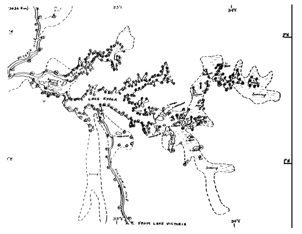
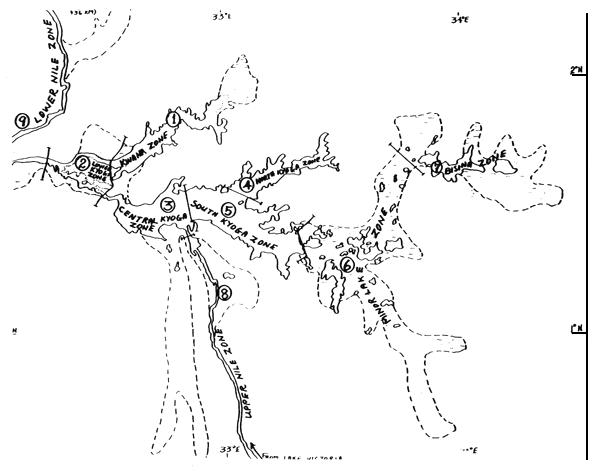
The fishing area of Lake Kyoga can be divided into nine strata (Fig. 5) on the basis of some identifiable similarity in the ecological make-up of the aquatic ecosystem (Worthington 1929 and, Orach-Meza, 1973). As expected, this stratification also reflects the similarities of the kind of fishing canoes used in each stratum (Table 3). Since each stratum is assumed to be homogeneous, in that the counts vary little from one unit of measurement to another, it is expected that a precise estimate of any stratum mean can be obtained from a small sample in that stratum. These estimates can then be converted into the estimates of the total number of counts from which a precise estimate for the whole lake can be computed.
Optimum allocation of the fish landing centres in order to achieve an estimate of the average number of canoes within each stratum with a given relative precision is given by equation (a) Appendix I. The other parameters employed are given by equations (b) to (f).
The total sample size (n) for a relative precision of 5 per cent using the data in Table 2 would therefore be:
n = (3971.4)2 /(102848.5 + 141917.5) = 64 landing sites.
So that instead of surveying 118 landing centres, only 64 centres would be surveyed to give statistically accurate result with the same level of precision. Furthermore, if these 64 centres are optimally allocated to the strata, it would give the smallest variance for the estimated total fishing vessels for the fixed sample size of 64 (Bazigos, 1974). Results of the example are listed in Table 3. But if all the within-stratum variances are equal, proportional allocation could be employed (Cochran, 1963).
In order to reduce the possibility of variation within each stratum further, the allocated sample size can be distributed using random and unequal probability selection which is proportional to size (cochran, 1963) before actual counts are made. For example Stratum 1, with a total of 23 landing centres of which only 9 are allocated to be sampled, can be sub-divided as followa and as shown in Table 4:
| Small centres | - | landings with 15 or less canoes |
| Medium centres | - | landings with 16 to 30 canoes |
| Large Centres | - | landings with more than 30 canoes |
This would assure the optimisation of (a) accuracy required for estimates of the number of counts within the stratum, and (b) convenience and practicability with respect to management and the number of enumerators available. Should money be the limiting factor, the sample size can be reduced accordingly at the expense of increasing the estimation error since the standard error of the estimates depends closely on the number of samples.
Where the cost of enumerating canoes at respective landing centres is known, the expression in equation (g) is used for estimating the sample size for a fixed cost (Cochran, 1963). The estimated total counts for the fisheries is expressed by equation (i), and the variance of the estimated total from optimum allocation is given by equation (j), with a coefficient of variation (the standard error expressed as a fraction of the total counts) given by equation (k).
(d) Catch Assessment
The above sampling design can be usefully employed for estimating the total number and weight of fish caught by simply stratifying canoes at any sampled landing centre into types of fishing boats (i.e. planked canoe with outboard motor, planked canoe without outboard motor, and dug-out canoe). If detail distribution of the catch by species and sizes is to be analysed, further stratification into kinds of fishing gears (i.e. clusters of gill-nets, long-lines, and fish traps by sizes within types of fishing canoes) is necessary. As with landing centres, not all the stratified units (boats, gears) can be inspected for the estimation of total catch of fish. An optimum number of the kinds of boats, and/or gears is sampled on the basis of the variance and total catch (weight or number) or a previous but a more recent and most reliable record.
The importance of stratifying the canoes and gears is pretty obvious. A gill net of 4" mesh and one of 8" mesh will obviously catch different sizes of fish, and will often be catching different species. The planked canoe may be able to travel farther than the dug-outs, and those with outboard motors may go even further, and may thus be fishing different ecological grounds. Since the number and types of fishing boats in use at each landing centre are known, the best that can be done mathematically is to insure that every boat within each sub-stratum has an equal chance of being included in the optimum size of sample taken. At present, it can only be assumed that the fishing gears in use are proportionally represented in the canoes sampled.
Considering that only the fish caught is brought to the landing centre, and very rarely the gears used in capturing the fish, it may be just as well to record the catches by canoes rather than placing statistical reliance on reports by fishermen. When a reasonable distribution of gears by canoes is eventually known, or can be determined than a two-stage or three-stage stratified sampling design with the respective optimum allocation of the sample sizes can be appropriately applied for the estimation of catches by sizes, species, etc.
One o the best methods of sampling from the sub-strata (the stratified boats by types) is to systematically sample the boats by their landing order, so that boats fishing further as well as closest from the landing centre, or the crews which were idle and got up late and those that went out early all get equal chance of being selected. Since the optimum number of boats to be selected from each sub-stratum would be known, the rank of arrival to be picked for inspection can also be selected in advance by random sampling in any of the following ways:-
The lottery method - by drawing lots.
The use of random numbers from published tables of random digits.
Systematically following the order of arrivals of canoes at fish landing.
Ideally, each landing would be visited each day, but this is practically impossible at present for many lake fisheries. The landings can be visited only a few times each month. It is therefore necessary to randomise the order of visits because catches could easily be influenced by the moon phase, tidal strength, or some periodic biological or physical factor, so that the collection of landing figures in the same order on every occasion could give results which may lead to wrong conclusions.
The catch from each boat sampled is sorted, identified by species, counted and weighed. The desired information is recorded on a pre-planned form (Appendix II and III). Appendix III is the proposed form. The total catch for each sub-stratum (boat type) is calculated from the average catch of the respective sampled canoes. Summing these gives the total catch for the landing centre sampled that day (i.e. one day). Total catch in a month for the centre is then easily calculated from the number of sampling days. Assuming a 26-day fishing month and 4 sampling days, the monthly catch for a landing centre is calculated by using formula (1) in Appendix 1.
The monthly landings for each of the 9 ecological strata is then obtained from equation (m). Totalling the above estimates gives the monthly fish landings for the fisheries as a whole as in equation (n). The annual estimates are similarly obtained by pooling the monthly catches as in equation (o). The variance of the monthly catch estimates is calculated by using similar methods as in equation (j). The precision of the total catch Y, as well as its confidence interval are given in equations (p) to (u).
Stratifying heterogeneous fishing areas and fishing vessels (as well as fishing gears when statistically feasible) before sampling the stratum catch increases the precision and accuracy of the total estimates greatly. The division makes each stratum homogeneous for independent sampling and estimates which can be combined to give an estimate for the whole fisheries. The variance of the estimate is also obtained by combining the variance of the stratum estimates. Since each stratum is relatively homogeneous, variation of catch estimates within each one is expected to be small, so that the variance of the final combined estimate will also be small - much less than without stratification.
It is suggested that for stratum 9 (minor lakes) near Lake Kyoga, each small lake should constitute a landing centre except for Lake Nakuwa which already has 5 landing centres considered as main. Where the landing centres are diffused or scattered along the shoreline, every attempt should be made to encourage the fishermen to land at designated centres nearby. It this is not possible, the sampler may have to cover a strip of shoreline designated as a sampling or landing centre. This may be applicable in strata 8 and 9. The use of a motorized canoe is necessary in such a case.
An ultimate objective of any sampling design is to obtain accurate estimates on the characteristics of the population, when to do a complete coverage is either physically impossible of economically impracticable. Accurate data collection on the selected statistical units is therefore of prime importance, because management planning for the future is all dependent upon a good knowledge of the amounts of fish being caught in various zones by different fishing techniques. Unless this work is done carefully, honestly, and thoroughly, the returns would give a false impression of the state of the fisheries.
The data form proposed (Appendix III) is based on the expectation that a truly random sample fairly represents the whole catch of an area. The samples must therefore be collected in the time, place and manner specified. The sampler must sort, classify, count, and weigh the catches from the ‘right’ boats, count the respective gears used (if available or if they can be reliably ascertained from the fisherman's report), and check the sizes and then record the results correctly on the form provided. This should be accompanied by on-the spot surprise inspections by Senior staff from Headquarters. Such a procedure would minimise the sampling error tremendously, and improve the accuracy of the estimates greatly.
This design assumes that there is no difference between the catches of sampled canoes within a landing centre and between landing centres within a real stratum at the selected level of significance (normally = 0.05). The number of canoes sampled for inspection from sampled landing centres within each stratum is expected to insure this high level of precision. An analysis of variance or regression analysis coupled with experimental fishing can be applied to verify the assumptions.
Bazigos, G.P. 1974. The Design of Fisheries Statistical Surveys - Inland Water - U.N., F.A.O., Fish Tech. Pap. 133, 122pp.
Cochran, W. G. 1963. Sampling Techniques. John Willey & Sons. Inc. N.Y., 413pp.
Dhatemwa, C. 1973. Aerial Counts of Fishing Vessels on the Lakes of Uganda. Manuscript - A report to the Fish. Dept., Uganda.
Orach-Meza, F. L. 1972. Survey of Production Factors of Lake Kyoga Fisheries. Manuscript - A report to the Fisheries Department, Uganda.
Orach-Meza, F.L. 1973. Annual Report - 1972. Manuscript - A Report to the Fish. Dept., Uganda.
Proude, P.D. and R.P. Newton, 1960. Aerial Survey of Fishing vessels of Lake Kyoga Region., Manuscript - A report to Fish. Dept., Uganda.
Rogers, P. 1970. Annual Report, 1969. Manuscript - a Report to Fish. Dept., Uganda.
Snedecor, G.W. and W.G. Cochran. 1973. Statistical Methods. Iowa State Univ. Press, Ames. 593pp.
Stoneman and Rogers. 1970. Occasional papers, Ministry of Animal Industry & Fisheries, Uganda.
Worthington, E.B., 1929. A report on the Fishing Survey of Lakes Albert and Kyoga. Crown Agents, London, S.A.L., 136pp.
| (a) | nk | = | n(Nk Sk) / (∑Nk Sk) |
| (b) | n | = | (∑Nk Sk)2 / (Vo + ∑Nk Sk2) |
| (c) | Vo | = | (CV.∑Bki)2 |
| (d) | CV | = | (Sst) / (∑Bki) |
| (e) | S2st | = | ∑(W2k S2k / nk) |
| (f) | S2k | = | [∑B2ki - (∑Bki)2 / Nk] / (Nk-1) |
| Bki | = | number of boats counted at the ith landing and in the kth stratum, | |
| Bk | = | mean number of boats per landing centre; | |
| Nk | = | number of landing centre in kth stratum; | |
| nk | = | number of landing centres optimally allocated in the kth stratum; | |
| N | = | total number of landings; | |
| S2k | = | stratum variance; a small value implies that the probability of a large deviation of the means of the landing centres from the stratum mean is small; | |
| CV | = | Coefficient of variation; | |
| Vo | = | expected precision of the overall estimate; | |
| W | = | Nk/N. | |
| S2st | = | Stratified variance | |
| (g) | 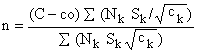 | ||
| (h) | 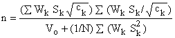 | ||
| Where: | C = | Total cost | |
| co = | overhead cost | ||
| ck = | cost per landing centre; this may vary from stratum to stratum and may be proportional to the size of sample. | ||
| Wk = | Nk/N | ||
| (C - Co) = total sampling cost less overhead cost. | |||
| (i) | 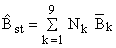 | ||
| (j) | 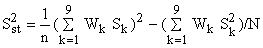 | ||
| (k) | (CV)st = | Sst / (∑Bki/n) | |
| (l) | yjkl = | (26/4)∑X1 | |
| where X1 is the sum of the catches for the totalnumber of sampling days spent at the landing centre 1th (in this case 4). | |||
| (m) | 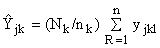 | ||
| where Yjk = | estimated catch for the jth month and kth stratum; | ||
| Nk = | number of landing centres in the kth stratum; | ||
| nk = | total number of landing centres sampled in the kth stratum; | ||
| yjkl = | estimated catch for 1th landing centre, in the kth stratum and for jth month. | ||
| (n) |  | ||
| (o) |  | ||
| (p) | 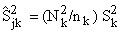 | |
| where S2k is the estimate of the stratum variance which is given by:- | ||
| (q) | 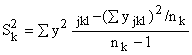 | |
| The estimated variance of Y. and Y.. are given respectively by:- | ||
| (r) |  | |
| (s) | 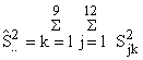 | |
| (t) | Y | = Ŷ.. ± 1.96 S.. |
| (u) | CV.. | = S.. / Y |
Table 1. DISTRIBUTION OF LANDING CENTRES AND FISHING VESSELS BY THE EXISTING SAMPLING ZONES AS OF 1973
| Survey Centres by Districts | Landing Centres | Number of Fishing Vessels | ||||
| Planked/Motor | Planked | Dugout | ||||
| TESO | ||||||
| Kaberamaido | 7 | + | (4) | 17 | 146 | 198 |
| Soroti | 3 | + | (1) | 1 | 103 | 167 |
| Bugondo | 5 | + | (6) | 44 | 93 | 81 |
| Labori | 7 | + | (2) | 12 | 104 | 188 |
| Serere | 6 | + | (6) | 1 | 39 | 507 |
| Ngora | 3 | + | (10) | 1 | 30 | 336 |
| Kumi | 10 | + | (3) | 2 | 132 | 275 |
| LANGO | ||||||
| Maruzi | 6 | + | (5) | 12 | 381 | 313 |
| Kwania | 10 | + | (10) | 5 | 325 | 421 |
| Namasale | 6 | + | (3) | 28 | 39 | 62 |
| Amolatar | 8 | + | (3) | 19 | 43 | 22 |
| EAST BUGANDA | ||||||
| Bugerere | 10 | + | (4) | 22 | 149 | 221 |
| Buruli | 10 | + | (3) | 96 | 386 | 94 |
| BUSOGA | ||||||
| Kagulu | 11 | + | (2) | 58 | 98 | 265 |
| Kidera | 8 | + | (4) | 65 | 149 | 262 |
| BUKEDI | ||||||
| Passisa | 5 | + | (9) | 0 | 28 | 283 |
| BUNYORO | ||||||
| Kibanda | 3 | + | (1) | 1 | 6 | 51 |
| TOTAL = 17 | 118 | + | (67) | 384 | 2284 | 3746 |
(x): Isolated landing centres with less than 4 canoes each
and those spread along the shoreline. These are rarely
surveyed due to lack of access roads. Many of them are
often observed | ||||||
Table 2. ZONATION AND THE DIVISION OF LANDING CENTRES AND FISHING VESSELS
| ZONES (Fig. 4 & 5) | LANDING CENTRES | FISHING VESSELS | |||
| PLANKED | DUGOUT | ||||
| 1. LAKE KWANIA | 23 | + | (0) | 453 | 484 |
| 2. LAKE KYOGA (LOWER) | 4 | + | (1) | 278 | 147 |
| 3. LAKE KYOGA (CENTRAL) | 19 | + | (8) | 630 | 177 |
| 4. LAKE KYOGA (NORTH) | 12 | + | (11) | 292 | 407 |
| 5. LAKE KYOGA (SOUTH) | 18 | + | (12) | 575 | 526 |
| 6. MINOR LAKES | 21 | + | (24) | 144 | 1057 |
| 7. LAKE BISINA | 10 | + | (3) | 136 | 321 |
| 8. UPPER VICTORIA NILE | 7 | + | (5) | 133 | 326 |
| 9. LOWER VICTORIA NILE | 4 | + | (3) | 27 | 301 |
| TOTAL = 9 ZONES | 118 | + | (67) | 2668 | 3746 |
(x) : As for Table 1.
Table 3. ESTIMATES OF SAMPLE SIZE AND COMPUTATION UNITS
| STRATUM | Nk | Sk | NkS2k | NkSk | nk |
| 1 | 23 | 23.93 | 13173.3 | 550.4 | 9 |
| 2 | 4 | 41.98 | 7049.3 | 167.9 | 3 |
| 3 | 19 | 29.52 | 16557.2 | 560.9 | 9 |
| 4 | 12 | 34.01 | 13880.2 | 408.1 | 7 |
| 5 | 18 | 31.12 | 17432.2 | 560.2 | 9 |
| 6 | 21 | 48.76 | 49928.3 | 1024.3 | 17 |
| 7 | 10 | 27.64 | 7639.7 | 276.4 | 5 |
| 8 | 7 | 43.10 | 13003.3 | 301.7 | 6* |
| 9 | 4 | 50.28 | 10112.3 | 201.1 | 3 |
| TOTAL | N = 118 | 148775.8 | 414007 | n = 68 |
Table 4. SUBDIVISION OF STRATUM # 1: (LAKE KWANIA ZONE)
| SUB-STRATUM | Nk | Sk | NkS2k | NkSk | nk |
| 1 | 4 | 2.08 | 17.33 | 8.32 | 1* |
| 2 | 4 | 2.06 | 17.00 | 8.24 | 1* |
| 3 | 15 | 21.17 | 6723.86 | 317.55 | 9 |
| TOTAL | N = 23 | 6758.19 | 334.11 | n = 9 |
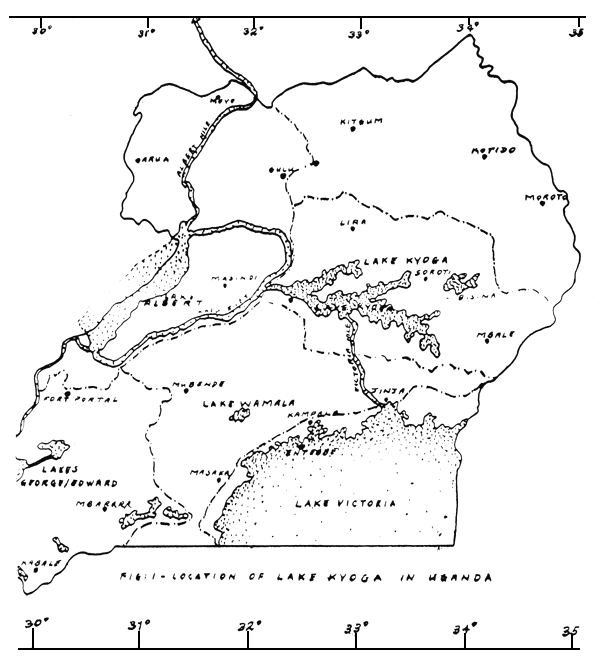
FIG. 2a TRENDS IN TOTAL CATCHES
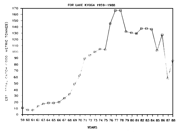
FIG 2b NO. OF OPERATING CANOES
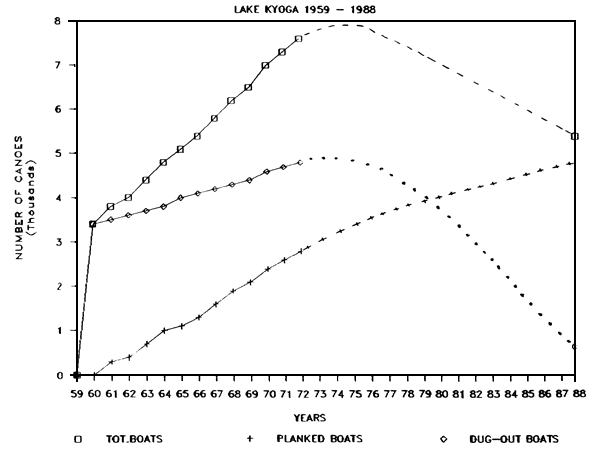
FIG. 3
DISTRIBUTION OF CANOES ON THE AQURTIC SYSTEM OF LAKE KYOGA FISHERIES AS SEEN
DURING AERIAL COUNTS ON 15 AND 16 FEBRUARY 1960 (AFTER P.D. PROUD & R.F. NEWTON, 1960).
TOTAL NUMBER OF CANOES SEEN ≃ 2583 ~ 99% DUGOUTS.
| AREA | ~ 3050 KM2 |
| SHORELINE | ~ 1978 KM |
| VOLUME | ~ 23.79 KM3 |
| ALTITUDE | ~ 1032 M |
| # CANOES | ~ 2383 |
FIG. 5: PROPOSED STRATIFICATION (ZONATION) OF THE FISHING AREA
| AREA | ~ 3050 KM2 |
| SHORELINE | ~ 1978 KM |
| VOLUME | ~ 23.79 KM3 |
| ALTITUDE | ~ 1032 M |
| Fisheries form No. F.K.I | |
| SAMPLE SURVEY FOR ESTIMATION OF FISH CATCH ON SHORE OF LAKE | |
| PARTICULARS OF SAMPLE CATCH LANDED BY NETS/GEAR OTHER THAN NETS/ON SELECTED DAYS AT LANDING | |
| Date | |
| Boat Reg No | Time of return | Gear | T. esc | T. var | T. zilli | Bagrus | Barbus | Clartas | Lates | Mormyrus | Protop | TOTAL | |||||||||||||
| Type | No. and size | No. | Wt. | No. | Wt. | No. | Wt. | No | Wt. | No | Wt. | No | Wt. | No | Wt. | No | Wt. | No | Wt. | No | Wt. | No. | Wt. | ||
| TOTAL | |||||||||||||||||||||||||
| Unit Price (average) | |||||||||||||||||||||||||
| TOTAL VALUE Shs. | |||||||||||||||||||||||||
| Total number of canoes at landing | |||||||||||||||||||||||||
| Total number of canoes recorded | |||||||||||||||||||||||||
| Total number of canoes actually fishing | Signature of Fisheries Assistant | ||||||||||||||||||||||||
Fisheries Form # F.K.1
SAMPLE SURVEY FOR ESTIMATION OF FISH CATCH
| Name of Fishing Zone: | Type of Boat: |
| Name of Landing Centre: | Total Boats Fishing: |
| Sampling Month and Year: | Total Boats Sampled: |
| Sample # | Sample # | |||||||||||||||||
| Name of Recorder | ||||||||||||||||||
| Name of Fisherman | ||||||||||||||||||
| Boat Registration # | ||||||||||||||||||
| Gear Used | ||||||||||||||||||
| Time Spent Fishing | ||||||||||||||||||
| # Gears Used | ||||||||||||||||||
| Size or Mesh | ||||||||||||||||||
| Species Sampled | # | G | W | # | G | W | # | G | W | # | G | W | # | G | W | # | G | W |
| TOTAL | ||||||||||||||||||
# Number of fish (total);
G = Number of fish gutted;
W = total weight of the species

![]()