![]()
![]()
FISHIN PROJECT
BIOSTAT REPORT NO. 21
20/11/90–20/12/90
By
J. IKWAPUT
BIOLOGIST/STATISTICIAN
|
ABSTRACT This report highlights the Frame Survey conduct in the Masaka Fisheries Region of Lake Victoria. Logistics involved, constraints encountered by the team, and observations made by the supervisor are given. A brief summary of the Frame Survey results for Masaka Region is also given. |
January, 1991.
1. INTRODUCTION:
As part of the overall Frame Survey (FS) on Lake Victoria, the execution of the FS part in Masaka region was carried out from 20/11/90–20/12/90. The survey was conducted using the on-water approach by two staff from Masaka region, namely Mr. T. Kawuma and Mr. C Ayo-Owiny, both Assistant Fisheries Development Officers (AFDOs) and was supervised by Miss J. Ikwaput from Project Headquarters.
Both survey team members had earlier participated in the refresher course organised before the onset of the FS. Mr. Kawuma was well versed in the operation of the engine and maintenance of the survey boat, so he acted as the coxswain as well as the enumerator during the survey in Masaka Region, the last administrative region to carry out the frame survey. The delay was caused by lack of a boat and an engine. The team had to wait for the Entebbe team to complete their survey before they could start because they had to use the same boat and engine.
2. CONDUCT OF THE SURVEY:
Miss J. Ikwaput, accompanied by Mr. P. Kisaamo, Economist from the Project Headquarters, travelled to Masaka Region on 20th November, 1990 to deliver the survey items (see Appendix I). They met the survey team together with the RFO Masaka and the staff working in Katebo fishing area at Buwama Trading Centre on Masaka road. The group moved on to Katebo Pier Site where the boat and other survey equipment were unloaded. The RFO and the staff from Katebo fishing area returned to their duties while the survey team together with the headquarters staff set off for Ssenyendo Landing on Bunjako Island where they spent a night. On the morning of 21st November, 1990, the survey was launched starting with the landings on Bunjako Island. The headquarters' supervisor had the opportunity to explain to the survey team the procedures to be followed during the survey and demonstrated to them how to fill in the questionnaires.
Like in the other regions, the survey in Masaka region was conducted using purely water approach. The staff travelled close to the shoreline and, with the help of a pair of binoculars, identified all landings points. Once a landing was sighted, the team landed there and located the point on 1:50,000 scale maps which they were carrying along. The point was marked on the map using a pencil and a map code was assigned to it. These map codes were filled in the Fraforms A1 and A2 for identification purposes (see Annex I).
The supervisor visited the field on three different occasions. The first visit was when survey items were being delivered and the supervisor participated in the start of the survey. The second visit was a one day visit when the supervisor took more supplies and the third visit was to deliver more supplies and also to participate in the survey. A complete itinerary is given as appendix III and list of persons met during the visits is given as appendix II.
During the first visit, the Headquarters team stayed with the survey team for 4 days and covered the following landings:
Bunjako Island:
Bunjako Island is found in Mpigi District and has a number of landings, namely : Makungu, Kyabagwe, Bukiina, Bukasa, Ssenyondo, Busimuzi, Bugoma, Buzami, Buzami A, Buzami B and Lubembe. The Island is separated from the mainland by a stretch of swamp with a river of about 2 km width flowing through the swamp.
Other Landings:
Apart from the landings on Bunjako Island the team also covered other landings in Mpigi District and these included : Mikita (situated in a swamp), Buyinga (accessed by a small channel which is quite deep up to the landing), Buvumbo (on the mainland but hidden by a swamp and the entry is a winding narrow channel of about 1.5 miles), Katebo Pier, Katebo landing and Butebo Pier Site.
Katebo Pier was formerly developed by the East African Railways and Harbours. The Pier is no longer functioning and the landing point is now used by the transport boats which bring both people and fish from the islands to the mainland, especially on market days which are held every week on Fridays. There is a growing market near the landing which operates on weekly basis. Katebo Landing which had been developed for landing fresh fish has now been abandoned and it is being used as a resting place for some boats. The fishermen have again reverted to using Butebo Pier site which they had earlier on abandoned (Ikwaput & Coenen, 1990). Butebo Pier Site is very rocky and not suitable for landing because it is not an easy entry for powered boats. However, most fishermen have small boats which are easy to manoeuvre.
The team also covered the landings of Namirembe ‘A’ and Namirembe East which are situated in Katonga swamp in Mpigi District near the boarder with Masaka District. Entry to Namirembe ‘E’ is found within the Swamp and can easily be missed. It is a winding channel of about 1.25 Km long which is quite narrow. The landing point itself is very muddy and big boats can not reach up to the dry land but have to stop about 10 meters away and use dug-out boats for ferrying their goods to the land. The landing has got temporary eating shelters and land access is by a foot path. Transport from the landing to the main road is by bicycles.
The team from the headquarters stopped at Namirembe ‘E’ fish landing and returned to the office while the regional survey team continued with work.
The supervisor checked on the team on 30/11/90 at Bukakata fish landing in Masaka District where they were given further supplies of 10 jerrycans of fuel plus more questionnaires. The Team reported that they had incurred some expenses in the field where they had to hire labour to transport the engine and fuel plus their camping equipment to the camping sites whenever they had to sleep some distance away from the landings. They had also encountered lack of co-operation from fishermen in areas where drift nets and beach seines are being used because fishermen were not willing to give information on these forbidden fishing gears.
After getting fresh supplies of fuel and more forms, the team continued with the survey along the shoreline up to the Tanzania border before crossing to the part of Buggala Island (Ssese) which was assigned to them. They crossed to the Island on 9/12/90 and covered the northern portion of the island from Bugoma ferry landing to Bubondo point, situated in Bumangi Bay. They returned to Bukakata landing on 14/12/90 after running out of fuel. A message was sent to the headquarters for more fuel.
The third visit to the field was on 18/12/90 to deliver more fuel. This time the supervisor from the headquarters accompanied the team to the island where they covered the remaining southern part of the island from Bugoma to Lwanama pt. in Williams Bay. The team covered the landings of Nabisukiro, Kidiba, Senero, Mutambala, Nankombe, Mpanga and Kinyu. All these landings are found lying on the southern part of Buggala Island. This part of the island is open to strong winds and there is a lot of wave action which has led to thick deposits of sand along the shore which can be a length of about 10 meters from the water edge running into the lake in some areas. This makes the entry to this landings very shallow and very difficult to land especially for big canoes with engines. In some cases the team had to leave the boat in the water and wade to the shoreline. The strong waves also make it difficult to land and to launch the boat from this part of the lake. The survey was finalised on 20th December 1990 and this marked the end of the Frame Survey on Lake Victoria.
The equipment which was used for the survey was returned to the headquarters while the boat was moored at Bukakata fish Landing and the engine left at the RFO's place for custody.
3. OBSERVATIONS :
The survey was conducted smoothly with a few days of delays in the middle caused by lack of fuel. Fuel was always secured at the headquarters and carried to the regions because, due to a general shortage of fuel in the country, most fuelling areas along the shoreline were not receiving fuel supplies.
Most boats had their boat cards (Fraform.A2) filled in, except for those boats which were not found at the landing at the time of visit.
The fishermen in this part of the lake were more co-operative than in other parts of L. Victoria and most of them were always found at the landings. Also the survey team members were at advantage because they happened to be known among the fishermen in most of the areas. Where they were not known, they were always accompanied by resident fisheries staff except in the Ssese island part.
4. PROBLEMS:
4.1 Fishing Gears:
Use of illegal fishing methods were encountered during the survey, especially around Bukakata area where “tycoon” fishing was observed at night and beach seines encountered in most nearby landings. There was also a lot of Rastrineobola light fishing near Bukakata where the whole lake appeared like a city at night. Most of those engaged in this fishery come from Lambu and Kachanga landings. When those landings were visited in the morning, fishermen were seen hiding lantern lamps and mosquito nets on sighting the fisheries boat approaching. It was difficult in such cases to ascertain the number of nets being used for Rastrineobola fishery since the owners were not willing to give information. Rastrineobola fishery is carried out at night and the government has put a ban on night fishing which makes Rastrineobola fishing illegal.
4.2 Staff.
Most landings don't have resident fisheries staff but are visited by staff from nearby landings. However, there are some landings which are found in swampy areas and are not easily reached by land. These are not visited because the staff don't have water transport. The whole lake shore in the region is covered by a total of 19 fisheries staff, out of which 4 are AFDOs, 14 are Fisheries Assistants (FAs) and 1 Fish Guard. A complete list of all the staff together with the landings they are covering is given in Appendix IV.
5. RESULTS:
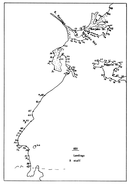
The Masaka Frame Survey team covered the area between Namugobo Landing (near the ending point of the Lake Victoria East Survey part) up to the Tanzanian border. A total of 83 fish landings were surveyed on the mainland and on the part of Ssese main Island which was given to the team. A complete list of all the landings surveyed is given in Appendix V. Attached is a map showing the area covered by the team. The landing points are marked with dots and map codes, while the staff disposition is marked with an X with a subscript number indicating the number of resident staff (see Annex 1).
A total of 1338 active boats were recorded by the survey team. Out of these, 54 were reported to be transport boats, while 1284 were reported to be fishing boats. There were 716 dug-out canoes recorded and only 622 planked canoes. The team recorded 124 powered canoes.
A total of 1191 active canoes were enumerated in the Masaka region administrative area while 147 were enumerated in the Ssese Island part.
Buvumbo fish landing had the highest number of active canoes (116). All of these were fishing canoes with 94 of them being dug-out canoes. This was followed by Bulingu landing which recorded 100 active canoes, all of them fishing and dug-out; Nakigga which recorded 88 active canoes all of them dug-outs; and Lambu landing which recorded 88 active canoes (82 planked, 6 dug-out) out of which 85 were fishing and 3 transport canoes.
The landing with the highest number of powered canoes turned out to be Ddimu with 27, followed by Namirembe ‘W’ with 23 and Kaziru with 18 canoes. All these were used for fishing activities. Lambu landing recorded the highest number of planked canoes (82), followed by Ddimu (32). The landing with the highest number of transport canoes was Namugobo with 19, followed by Kabasese with 17 and then Luku and Malembo landings, each with 4 canoes.
Only 9 landings had transport canoes. Namugobo landing in Mpigi district had the highest number of transport canoes (19). These are used to transport both people and goods from Bussi island to the mainland. Kabasese, commonly known as Bukakata Pier, was the second with 17 transport canoes. This landing happens to be the entry point in Masaka district for processed fish from Ssese islands.
37 (44.58%) of the landings in the surveyed area had less than 10 canoes while 25 (30.12%) landings had less than 5 canoes. During the survey it was observed that there was a higher concentration of dug-out canoes in the Mpigi District part of the survey area. This happens to be an area lying in a swampy area which makes it difficult to use bigger canoes. Fishermen find it easier to manoeuvre the small parachutes, which in this case have been classified under the dug-outs as opposed to the bigger planked canoes. As one moves to the south western part of the lake, i.e. towards the Tanzanian border, the number of dug-outs reduces. The reason is that the waters here are very open and use of dug-outs is not very safe as the winds tend to be strong.
The table below shows the landings with the highest number of canoes in each category.
| LANDING | ACTIVE CANOES | FISHING CANOES | TRANSPORT CANOES | PLANKED CANOES | DUG-OUT CANOES | POWERED CANOES |
| Buvumbo | 116 | 116 | 0 | 22 | 94 | 9 |
| Bulingu | 100 | 100 | 0 | 0 | 100 | 0 |
| Nakigga | 88 | 88 | 0 | 0 | 88 | 0 |
| Lambu | 88 | 85 | 3 | 82 | 6 | 3 |
| Ssanya | 67 | 67 | 0 | 4 | 63 | 0 |
| Ddimu | 32 | 32 | 0 | 32 | 0 | 27 |
| Kaziru | 29 | 29 | 0 | 29 | 0 | 18 |
| Namirembe ‘W’ | 27 | 27 | 0 | 27 | 0 | 23 |
| Namugobo | 26 | 7 | 19 | 4 | 22 | 0 |
| Kabasese | 26 | 9 | 17 | 18 | 8 | 0 |
6. WATER HYACINTH :
This water weed which is threatening Lake Victoria was observed at a number of landings. At almost all the landings visited between Buvumbo and Bukakata fishing area, some water hyacinth was observed. In some of these landings, the weed was taking root while on those with sandy beaches, the weed was drying up. Plenty of the weed was seen floating in the lake and being blown by the winds from Ssese islands towards the mainland. In Bukakata area itself, the weed had taken root and was widespread amongst the papyrus plants. There was quite a thick carpet on both sides of Bukakata Pier and eradication of the plant from this point is going to prove difficult. The plant had already flowered and formed seeds.
REFERENCES CITED :
Ikwaput J. & E. Coenen, 1990. Report on the trip to Masaka Region; Katebo Landing, Statdoc No. 13.
APPENDIX I
LIST OF SURVEY ITEMS
APPENDIX II
PERSONS MET:
| Mr. Mugerwa | RFO Masaka Region |
| Mr. Ayo Charles | AFDO |
| Mr. Timothy Kawuma | AFDO |
| Mr. Luutu S. | FA |
| Mr. Mugooda J. L. | FA |
| Mr. Kawooya Francis | FA |
| Mr. Ssentamu | Carpenter at Ssenyendo landing |
| Mr. Ssalongo | Both a farmer and fisherman |
| Fishermen at all landings | |
| RC1 officials on some landings | |
APPENDIX III
ITINERARY
| 20/11/90 | Depart Entebbe at 12.00 pm. Arrival at Buwama trading centre at 2.00pm. Arrival at Katebo Pier. at 4.00pm. Depart Katebo to Ssenyendo at 4.30 pm. Arrive at Ssenyendo at 6.00pm. and camped. |
| 21/11/90 | Departure from Ssenyendo to Buvumbo. Visited landings of Makungu, Kita, Buyinga, and Kisamba. On return journey visited Kyabagwe, Bukiina, Bukasa. Spent a night at Ssenyendo. |
| 22/11/90 | Worked at Ssenyendo and then left for Katebo Pier covering landings of Kwata, Buzami, Bugoma, Busimuzi and Lubembe. Camped at Katebo market near the landing. |
| 23/11/90 | Worked in Katebo Pier and left for Namirembe East landing covering landings of Butebo Site and Namirembe (A). Arrived at Namirembe East Landing at 11.00am. Worked at the landing and Departed at 12.30 p.m. for Entebbe. |
| 30/11/90 | Left Entebbe for Bukakata and back to Entebbe. |
| 18/12/90 | Left Entebbe for Bukakata and spent a night at Bukakata |
| 19/12/90 | Left for the island and covered the landings of Nabisukiro, Kidiba, Senero and spent a night at Mutambala. |
| 20/12/90 | Worked in Mutambala, Nankombe, Mpanga, Kinyu and returned to Bukakata for a night. |
| 21/12/90 | Returned to Entebbe. |
APPENDIX IV
FISHERIES STAFF IN MASAKA REGION FS AREA.
| NAME | TITLE | LOCATION | MAP CODES OF LANDINGS COVERED |
| S. Luutu | F.A. | Buvumbo | 002, 003, 004, 082, 083 |
| J. Mugooda | F.A. | Buwama | 005, 006, 008, 009, 011, 012, 014, 015 |
| Kassaja | F.G. | Katebo | 015 |
| T. Kawuma | AFDO | Buwama | Supervises Luutu and Mugooda |
| F. Kawooya | F.A. | Ggolo | 017, 018, 019, 020, 021, 022, 023, 024, 025. |
| P. Misango | F.A. | Ggolo | 017, 018, 019, 020, 021, 022, 023, 024, 025. |
| P. Mujuni | AFDO | Kamuwunga | 026, 027, 028, 029 |
| P. Muhumuza | F.A. | Kamuwunga | 026, 027, 028, 029 |
| E. Ssekandi | F.A. | Nakigga | 030, 031 |
| J.F. Kalule | AFDO | Bukakata | 033, 036, 037, 038, 039, 041 |
| C. Kyeyune | F.A. | Kabasese | 033, 036, 037, 038, 039, 041 |
| G. Lutwama | F.A. | Lambu | 040 |
| D. Turyamuleba | F.A. | Kaziru | 042 |
| Kibi-Kigongo | F.A. | Namirembe‘W’ | 043, 044 |
| R. Byarugaba | F.A. | Ddimu | 045, 047, 048, 049, 050, 051, 052 |
| E. Ssebunya | F.A. | Ddimu | 046, 047, 048, 049 |
| Kamugisha | AFDO | Ddimu | Supervisor |
| M. Mwesigwa | F.A. | Kasensero | 054, 055, 056, 057, 058, 059, 060 |
| P.L. Kagimu | F.A. | Kasensero | 058, 059 |
APPENDIX V
LIST OF LANDINGS SURVEYED BY THE TEAM.
| Landing | District | Map Code | ACTIVE CANOES | FISHING CANOES | TRANSPORT CANOES | DUG-OUT CANOES |
| Makungu | MPIGI | 1 | 8 | 8 | 0 | 4 |
| Buyinga | MPIGI | 2 | 30 | 30 | 0 | 26 |
| Kisamba | MPIGI | 3 | 10 | 10 | 0 | 10 |
| Buvumbo | MPIGI | 4 | 116 | 116 | 0 | 94 |
| Kyawagwe | MPIGI | 5 | 3 | 3 | 0 | 0 |
| Bukiina | MPIGI | 6 | 2 | 2 | 0 | 0 |
| Bukasa | MPIGI | 7 | 4 | 4 | 0 | 2 |
| Ssenyendo | MPIGI | 8 | 13 | 13 | 0 | 13 |
| Busimuzi | MPIGI | 9 | 4 | 4 | 0 | 2 |
| Bugoma | MPIGI | 10 | 3 | 3 | 0 | 1 |
| Buzami A | MPIGI | 11 | 13 | 13 | 0 | 0 |
| Buzami B | MPIGI | 12 | 3 | 3 | 0 | 2 |
| Buzami/Kaziru | MPIGI | 13 | 3 | 3 | 0 | 0 |
| Lubembe | MPIGI | 14 | 14 | 14 | 0 | 5 |
| Katebo | MPIGI | 15 | 28 | 28 | 0 | 7 |
| Namirembe A | MPIGI | 16 | 5 | 5 | 0 | 4 |
| Namirembe “E” | MPIGI | 17 | 13 | 13 | 0 | 6 |
| Kiwami | MPIGI | 18 | 11 | 11 | 0 | 11 |
| Namugeye | MPIGI | 19 | 19 | 19 | 0 | 8 |
| Mayuni | MPIGI | 20 | 11 | 11 | 0 | 9 |
| Kiwanga | MPIGI | 21 | 18 | 18 | 0 | 3 |
| Lwalalo | MPIGI | 22 | 31 | 31 | 0 | 3 |
| Luwuki | MPIGI | 23 | 7 | 7 | 0 | 0 |
| Nabisukiro | MPIGI | 24 | 4 | 4 | 0 | 1 |
| Nakaziba | MPIGI | 25 | 4 | 4 | 0 | 0 |
| Kamaliba | MPIGI | 26 | 15 | 15 | 0 | 3 |
| Kamuwunga | MASAKA | 27 | 20 | 20 | 0 | 18 |
| Bulingu | MASAKA | 28 | 100 | 100 | 0 | 100 |
| Kalangala | MASAKA | 29 | 10 | 10 | 0 | 10 |
| Nakigga | MASAKA | 30 | 88 | 88 | 0 | 88 |
| Katta | MASAKA | 31 | 12 | 12 | 0 | 12 |
| Mitondo | MASAKA | 32 | 13 | 13 | 0 | 13 |
| Kisuku | MASAKA | 33 | 22 | 21 | 1 | 20 |
| Makonzi | MASAKA | 34 | 5 | 5 | 0 | 2 |
| Bukoko | MASAKA | 35 | 12 | 12 | 0 | 12 |
| Kassa | MASAKA | 36 | 14 | 14 | 0 | 14 |
| Nakitokolo | MASAKA | 37 | 32 | 32 | 0 | 31 |
| Nabajja | MASAKA | 38 | 11 | 11 | 0 | 10 |
| Kachanga | MASAKA | 39 | 20 | 20 | 0 | 3 |
| Lambu | MASAKA | 40 | 88 | 85 | 3 | 6 |
| Kabasese | MASAKA | 41 | 26 | 9 | 17 | 8 |
| Kaziru | MASAKA | 42 | 29 | 29 | 0 | 29 |
| Namirembe W | MASAKA | 43 | 27 | 27 | 0 | 27 |
| Bbale | MASAKA | 44 | 10 | 10 | 0 | 10 |
| Kalokoso | MASAKA | 45 | 8 | 8 | 0 | 4 |
| Kisambazi | MASAKA | 46 | 3 | 3 | 0 | 2 |
| Ddimu | MASAKA | 47 | 32 | 32 | 0 | 0 |
| Malembo | MASAKA | 48 | 19 | 15 | 4 | 0 |
| Kasitamu | MASAKA | 49 | 7 | 7 | 0 | 3 |
| Nazigo | RAKAI | 50 | 1 | 1 | 0 | 1 |
| Kitaliga | RAKAI | 51 | 2 | 2 | 0 | 0 |
| Kasagulanyi | RAKAI | 52 | 2 | 2 | 0 | 1 |
| Nawangiri | RAKAI | 53 | 2 | 2 | 0 | 1 |
| Sango Bay | RAKAI | 54 | 11 | 11 | 0 | 7 |
| Toma | RAKAI | 55 | 4 | 4 | 0 | 4 |
| Kyabasimba | RAKAI | 56 | 8 | 8 | 0 | 3 |
| Kasensero | RAKAI | 57 | 23 | 21 | 2 | 3 |
| Lukunyu | RAKAI | 58 | 20 | 17 | 3 | 10 |
| Kabindi | RAKAI | 59 | 2 | 2 | 0 | 2 |
| Zzinga | RAKAI | 60 | 23 | 23 | 0 | 0 |
| Luku | KALANGALA | 61 | 11 | 7 | 4 | 6 |
| Kamugalula | KALANGALA | 62 | 12 | 12 | 0 | 10 |
| Kibanga | KALANGALA | 63 | 7 | 7 | 0 | 4 |
| Buziga | KALANGALA | 64 | 6 | 6 | 0 | 0 |
| Naziba | KALANGALA | 65 | 3 | 3 | 0 | 0 |
| Lugu | KALANGALA | 66 | 12 | 12 | 0 | 1 |
| Tubi | KALANGALA | 67 | 30 | 30 | 0 | 3 |
| Kasekulo | KALANGALA | 68 | 19 | 19 | 0 | 6 |
| Kikwayo | KALANGALA | 69 | 1 | 1 | 0 | 1 |
| Ssemasiga | KALANGALA | 70 | 2 | 2 | 0 | 0 |
| Kasenyi | KALANGALA | 72 | 1 | 1 | 0 | 0 |
| Kagolomolo II | KALANGALA | 73 | 3 | 3 | 0 | 0 |
| Nabisukiro | KALANGALA | 74 | 4 | 4 | 0 | 2 |
| Kidiba | KALANGALA | 75 | 6 | 5 | 1 | 1 |
| Senero | KALANGALA | 76 | 3 | 3 | 0 | 0 |
| Mutambala | KALANGALA | 77 | 10 | 10 | 0 | 5 |
| Nankombe | KALANGALA | 78 | 3 | 3 | 0 | 1 |
| Mpanga | KALANGALA | 79 | 5 | 5 | 0 | 5 |
| Kinyu | KALANGALA | 80 | 4 | 4 | 0 | 0 |
| Kibibi | KALANGALA | 81 | 5 | 5 | 0 | 0 |
| Ssanya | MPIGI | 82 | 67 | 67 | 0 | 63 |
| Namugobo | MPIGI | 83 | 26 | 7 | 19 | 22 |
TOTAL NO. OF LANDINGS = 83
ANNEX I SKETCH MAP SHOWING THE LANDINGS AND STAFF DISPOSITION IN THE SURVEYED AREA.
![]()
![]()