![]()
![]()
![]()
By
D. Nyeko
Abstract |
| Methods used in the conduct of a trial frame survey are described
and its results discussed in terms of number and distribution of
boats by types and function. Comparisons are made with an earlier
survey embracing the same area. |
March 1990
1. Introduction
An earlier Trial Frame Survey (TFS) was carried out along the Entebbe peninsular and the western shores of Murchison Bay (Lake Victoria) from 14th to 19th December 1989. This was done using Land Approach (LA). It embraced the fish landing of Nakiwogo on the most westerly end to Gaba fish landing on the eastermost end. This covered 11 fish-landings. Another TFS conducted between 7th and 9th of February was by Water Approach (WA). It covered the south and south-western shoreline of Entebbe including the Bussi Islands. A total of 26 fish landings were recorded (Appendix I, table 1).
This TFS was conducted at the Kome Island complex from 14th to 16th February 1990 to further test the TFS questionnaire for its adequacy. The Kome Islands complex, located in Mukono District, is fairly large (200km sq.) and near to Entebbe (35km.). There is a single fisheries staff and virtually no inputs for consistent statistical data collection.
The survey team consisted of Mr. O. K. Odongkara (Senior Fisheries Economist), Mr. Walakira (Fisheries Assistant In Charge Kome Islands), Mr. Y. Nkumire (coxswain) and Mr. D. Nyeko (Biologist/Statistician). They were joined on the second day of the TFS by Mr. M. Mugga (Kome Resistance Council 3-In Charge Defence).
The team left Entebbe pier on 14/2/90 at 11:00 a.m. using a 30 feet fibre glass canoe and arrived at Kasanvu landing (Nsanzi Island) in the afternoon (2:00 p.m.). The TFS was conducted from Nakayaga point along the northermost shoreline up to Kisigala point (Fig. 1). An operational base was setup at Lwazimirule landing that evening. On 15/2/90 the team left base at 8:00 a.m. and returned by 5:00 p.m. after having covered Tavu and Bulago Islands, parts of Kome Islands and one landing each of Damba and Dwanga Muto. On the final day, the team surveyed from the western tip of Kome Islands at Kisigala point, and continued up to Bugazi point before heading for Entebbe at 12:30 p.m.
2. Methodology
A thirty feet fibre glass canoe powered by a 25 Hp Johnson outboard engine was employed. In order to detect possible landings, one member covered the shoreline using 7 × 50, Field 7.1 degree field binoculars. Another marked the position of the spotted/visited landing precisely on a map (scale 1:50000) and awarded it a code. The code was denoted on a survey form used by the interviewer on the said landing (Appendix 2).
A “landing” was defined as “a place on the shore where fresh catches are landed. It may have smaller satellite places where catches are also landed, still representing the same landing, on the condition that any fisheries officer surveying that landing is able to adequately sample all incoming boats”. This definition seemed the most appropriate in view of designing a suitable CAS sampling system for landings in the future. Certain landings where the fishermen's dwellings are far away from the lake shore sometimes presented a problem of finding a respondent. Therefore, the information on some of these landings was usually gathered from fishermen in nearby landings. Such landings were few on the main Kome island, but on the mainland landings around Entebbe peninsular this situation was more often encountered (see App. 1, table 1).
3. Results
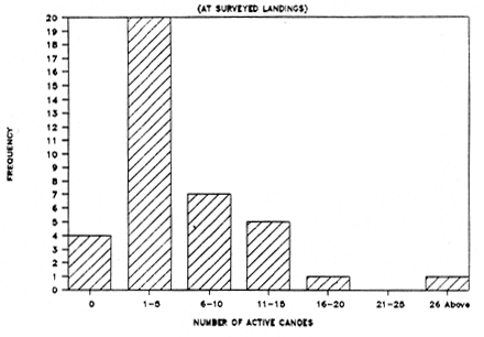
A total of 38 landings were covered (see App. 1, table 2). The coverage of northern Kome was completed except for Kimi Islands (X) and a possible landing on the small Island of Kisima (Y) (fig. 1). A total of 279 boats were enumerated of which 77 % were considered active. The frequency of the number of active canoes for these landings are given in Fig. 3. Four of these landings proved to be seasonal as they did not have any active canoes at the time of the survey due to migration to other landings. An “active boat” was defined as “one which is either operating or is expected to resume operation after a temporary ‘rest’ (loss of nets, disrepair of boats, non use of transport boats due to inadequate catches etc.”. A “non-active boat” was defined as “one which is abandoned or un-serviceable and not able to resume operation”. The latter were usually drawn up the landing and accounted for 23 % of the total number of enumerated boats. The majority of active boats (84 %) in the Kome Complex were planked. Most of these (95 %) were found to be fishing boats. Fishing boats accounted for 95 % of the total number of active boats. The ratio of planked to dug-out fishing boats was 5 : 1. All powered boats were planked and constituted 18.9 % of the active boats. This figure is less for powered fishing boats (15 %). Transport boats, however, are all powered. The mean number of fishing boats observed per landing was about 5 with an average of 3 crew per boat. Fish transport boats constituted a small fraction (5 %) of the active boats with an average of 2 crew per boat. The ratio of fishing boats to fish transport boats was 20 : 1.
4. Discussion & Conclusions
The Kome Island complex is remote and therefore the ratio of dug-out to planked boats is probably higher than in those areas first covered in Entebbe peninsular and Murchison bay. The TFS-LA (App. 1, Table 1) revealed a ratio of planked fishing boats to dug-outs of 43 : 1 compared to the Kome figure of 5 : 1 respectively. Planked boats probably support more fishing gear and men and possibly get better catches. The reverse is true of dug-out boats. Therefore, they are usually out-competed where fishing pressure is high. It follows that, other factors being constant, a higher dug-out ratio in an area like the Kome Complex may also indicate less fishing pressure compared to fishing areas of the mainland surveyed using LA (Graham, 1970 ; Pers. obs.)
The results of this TFS for north Kome Island was used for comparison to an earlier survey, Fisheries Sector Survey (FSS), conducted by the Planning Unit (PU) of the Ministry of Animal Industry and Fisheries (MAIF) from March to August 1988 (MAIF, 1989). Of the 38 landings covered in north Kome, only 14 were reported in that survey for the same area (fig 2). The TFS showed 171 planked fishing canoes compared to the FSS figure of 91. This difference can not be explained by fishermen migrations out of the Kome Island Complex fishery since it was only in 7 % of the TFS landings surveyed that respondents6666666 mentioned possible migration of some fishermen outside Kome Complex during lean fishing periods.
It can be concluded that the tested TFS questionnaire was found workable. The use of this questionnaire to conduct a Frame Survey (FS) for the whole of Lake Victoria is likely to provide reliable base-line data for the planning of an adequate Catch Assessment Survey (CAS). It was evident that the FSS data were not derived out of effective shoreline coverage. The FSS survey forms were distributed to Fisheries Assistants (FAs) without any follow-up due to lack of vehicles for the survey supervisors, poor communication facilities, poor roads, lack of public transport, etc. The FSS supervisors therefore had to content themselves with the incomplete knowledge of these FAs who could not cover the landings effectively either by water or by land (Sewankambo, 1989 ; EEC/AFRP/MAIF, 1989).
Literature cited
| 1. | EEC/AFRP/MAIF, 1989. | Fisheries Survey 1988., Euro. Econ. Comm. / Art. Fish. Rehab. Proj. / MAIF. FS890303.DOC : 9p. |
| 2. | Graham, A. D. 1970. | A Census of Fishing Canoes in Uganda : Report to the Uganda Fisheries Department by Wildlife Services Limited., Ugan. Fish. Dept. : 5p. 7 tables 8 plates |
| 3. | MAIF, 1989. | Results of Fishery Sector Survey (Lakes Victoria, Edward, George)., Plan. Unit Min. Anim. Indus. Fish. : tables 7p. |
| 4. | Sewankambo, F. 1989. | The Fisheries Sector Survey Project : Phase I Report., Plann. Unit Min. Anim. Indus. Fish. : 5p. 8 Annexes |
Fig. 1
SKETCH MAP OF KOME ISLANDS SHOWING SURVEYED AREA (MARKED 38 TO 76)
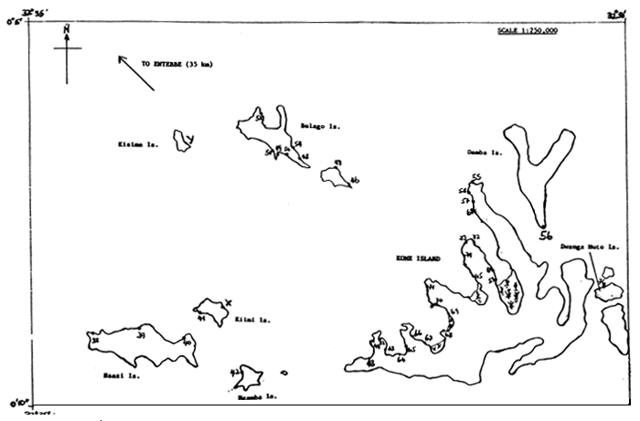
Fig. 2
SKETCH MAP OF KOME ISLANDS SHOWING LANDINGS
SURVEYED AS COMPARED TO AN EARLIER SURVEY
CONDUCTED BY THE FISHERIES SURVEY SECTOR
| Code Landing
38 Kansanvu | 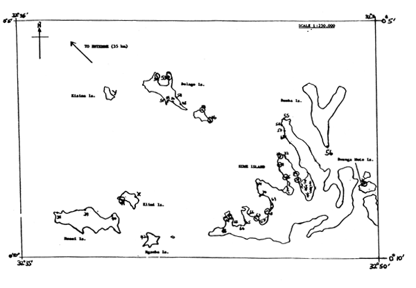 |
Fig. 3 : FREQUENCY OF NUMBER OF ACTIVE CANOES
APPENDIX I
Table 1
RESULTS OF TRIAL FRAME SURVEY
(USING A LAND APPROACH)
14th–19th December 1989
| Code Landing | Number of Boats | Number of active Boats | Non active Boats | Powered Active Boats | Number Fishing Boats | Number Planked Fishing Boats | Number Dugout Canoes | Number Powered Fishing | Number Crew Fishing Boats | Number Transp. Boats | Number Crew Transp. Boats | |
| 1 | Kigungu | 48 | 48 | 0 | 8 | 47 | 39 | 1 | 7 | 102 | 1 | 1 |
| 2 | Bugonga | 11 | 11 | 0 | 5 | 11 | 11 | 0 | 5 | 52 | 0 | 0 |
| 3 | Kitubulu | 26 | 26 | 0 | 7 | 26 | 26 | 0 | 8 | 65 | 0 | 0 |
| 4 | Nakiwogo | 25 | 25 | 0 | 1 | 25 | 24 | 1 | 1 | 72 | 0 | 0 |
| 5 | Kasenyl | 48 | 48 | 0 | 28 | 22 | 24 | 0 | 4 | 72 | 24 | 72 |
| 6 | Kokoo | 22 | 22 | 0 | 6 | 21 | 21 | 0 | 5 | 53 | 1 | 2 |
| 7 | Kagolomolo | 6 | 6 | 0 | 0 | 6 | 6 | 0 | 0 | 18 | 0 | 0 |
| 8 | Bugiri | 15 | 12 | 3 | 3 | 13 | 12 | 1 | 3 | 38 | 0 | 0 |
| 9 | Kivuvu Busabala | 19 | 18 | 1 | 3 | 18 | 18 | 0 | 3 | 54 | 0 | 0 |
| 10 | Bwerenga | 21 | 20 | 1 | 1 | 20 | 20 | 0 | 0 | 75 | 1 | 2 |
| 11 | Gaba | 63 | 58 | 5 | 46 | 14 | 12 | 2 | 5 | 38 | 44 | 92 |
| Total | ||||||||||||
| 304 | 294 | 10 | 108 | 223 | 213 | 5 | 42 | 639 | 71 | 169 | ||
RESULTS OF TRIAL FRAME SURVEY
(USING A WATER APPROACH)
7th–9th February 1990
| Code Landing | Number of Boats | Number of active Boats | Non active Boats | Powered Active Boats | Number Fishing Boats | Number Planked Fishing Boats | Number Dugout Canoes | Number Powered Fishing | Number Crew Fishing Boats | Number Transp. Boats | Number Crew Transp. Boats | |
| 12 | Tawo | 2 | 2 | 0 | 0 | 2 | 2 | 0 | 0 | 4 | 0 | 0 |
| 13 | Nakiyenje | 3 | 3 | 0 | 0 | 3 | 3 | 0 | 0 | 3 | 0 | 0 |
| 14 | Gajja | 3 | 3 | 0 | 0 | 3 | 3 | 0 | 0 | 6 | 0 | 0 |
| 15 | Kikukula | 3 | 3 | 0 | 0 | 3 | 2 | 1 | 0 | 3 | 0 | 0 |
| 16 | Musoli | 6 | 4 | 2 | 0 | 6 | 4 | 2 | 0 | 7 | 0 | 0 |
| 17 | Bauvi | 23 | 21 | 2 | 0 | 13 | 13 | 0 | 0 | 26 | 8 | 16 |
| 18 | Kyamyubu | 14 | 13 | 1 | 8 | 5 | 5 | 0 | 0 | 15 | 8 | 16 |
| 19 | Birega's Landing | 1 | 1 | 0 | 0 | 1 | 1 | 0 | 0 | 2 | 0 | 0 |
| 20 | Kitinda | 3 | 3 | 0 | 0 | 3 | 0 | 3 | 0 | 3 | 0 | 0 |
| 22 | Nagombe | 12 | 12 | 0 | 6 | 12 | 12 | 0 | 6 | 8 | 0 | 0 |
| 23 | Lugumba | 5 | 5 | 0 | 0 | 3 | 3 | 0 | 0 | 3 | 2 | 3 |
| 25 | Mabira | 13 | 13 | 0 | 0 | 13 | 6 | 7 | 0 | 32 | 0 | 0 |
| 26 | Kibuguma | 8 | 8 | 0 | 0 | 8 | 0 | 8 | 0 | 8 | 0 | 0 |
| 27 | Bitalo | 24 | 17 | 7 | 0 | 16 | 9 | 7 | 0 | 34 | 1 | 2 |
| 28 | Kikoko | 6 | 6 | 0 | 1 | 5 | 5 | 0 | 0 | 10 | 1 | 2 |
| 29 | Kakunyu | 0 | 0 | 0 | 0 | 0 | 0 | 0 | 0 | 0 | 0 | 0 |
| 30 | Kizinga | 5 | 4 | 2 | 0 | 3 | 3 | 0 | 0 | 8 | 1 | 1 |
| 31 | Nsonga | 4 | 4 | 0 | 0 | 4 | 3 | 1 | 0 | 10 | 0 | 0 |
| 32 | Kitufu | 3 | 3 | 0 | 0 | 3 | 3 | 0 | 0 | 9 | 0 | 0 |
| 33 | Kisanfu | 9 | 7 | 2 | 0 | 7 | 7 | 0 | 0 | 24 | 0 | 0 |
| 34 | Kinywante | 22 | 12 | 10 | 7 | 12 | 12 | 0 | 7 | 43 | 0 | 0 |
| Total | ||||||||||||
| 170 | 144 | 26 | 22 | 125 | 96 | 29 | 13 | 258 | 21 | 40 | ||
table 2
RESULTS OF TRIAL FRAME SURVEY
(KOME ISLANDS)
14th–16th February 1990
| Code Landing | Number of Boats | Number of active Boats | Non active Boats | Powered Active Boats | Number Fishing Boats | Number Planked Fishing Boats | Number Dugout Canoes | Number Powered Fishing | Number Crew Fishing Boats | Number Transp. Boats | Number Crew Transp. Boats | |
| 38 | Kansanvu | 34 | 28 | 6 | 4 | 27 | 27 | 0 | 3 | 72 | 1 | 3 |
| 39 | Tabaliro | 13 | 7 | 6 | 7 | 6 | 6 | 0 | 6 | 12 | 1 | 2 |
| 40 | Bugiri | 6 | 4 | 2 | 0 | 4 | 4 | 0 | 0 | 9 | 0 | 0 |
| 41 | Kiimi | 15 | 10 | 5 | 2 | 9 | 9 | 0 | 1 | 26 | 1 | 1 |
| 42 | Ngamba | 6 | 6 | 0 | 0 | 6 | 5 | 1 | 0 | 16 | 0 | 0 |
| 43 | Kampindi | 8 | 3 | 5 | 1 | 3 | 2 | 1 | 1 | 7 | 0 | 0 |
| 44 | Kisigala | 8 | 6 | 2 | 0 | 6 | 4 | 2 | 0 | 12 | 0 | 0 |
| 45 | Lwazimirule | 16 | 12 | 4 | 2 | 10 | 7 | 3 | 1 | 21 | 1 | 4 |
| 46 | Tavu1 | 6 | 3 | 3 | 0 | 3 | 2 | 1 | 0 | 8 | 0 | 0 |
| 47 | Tavu2 | 2 | 2 | 0 | 0 | 2 | 1 | 1 | 0 | 3 | 0 | 0 |
| 48 | Kajanga | 6 | 3 | 3 | 0 | 3 | 3 | 0 | 0 | 9 | 0 | 0 |
| 49 | Kavuma1 | 2 | 2 | 0 | 0 | 2 | 2 | 0 | 0 | 6 | 0 | 0 |
| 50 | Kavuma2 | 2 | 2 | 0 | 0 | 2 | 2 | 0 | 0 | 5 | 0 | 0 |
| 51 | Kavuma3 | 3 | 3 | 0 | 0 | 3 | 2 | 1 | 0 | 7 | 0 | 0 |
| 52 | Kasali | 11 | 9 | 2 | 5 | 7 | 7 | 0 | 3 | 24 | 2 | 4 |
| 53 | Nabisasiro | 9 | 8 | 1 | 1 | 8 | 8 | 0 | 1 | 24 | 0 | 0 |
| 54 | Banga | 0 | 0 | 0 | 0 | 0 | 0 | 0 | 0 | 0 | 0 | 0 |
| 55 | Bebe | 5 | 3 | 2 | 0 | 3 | 3 | 0 | 0 | 12 | 0 | 0 |
| 56 | Kakeka | 15 | 13 | 2 | 0 | 13 | 13 | 0 | 0 | 38 | 0 | 0 |
| 57 | Busiro1 | 5 | 3 | 2 | 1 | 3 | 3 | 0 | 1 | 8 | 0 | 0 |
| 58 | Busiro2 | 2 | 1 | 1 | 1 | 0 | 0 | 0 | 0 | 0 | 1 | 2 |
| 59 | Bugazi | 13 | 11 | 2 | 2 | 10 | 10 | 0 | 1 | 28 | 1 | 2 |
| 60 | Bugazi2 | 4 | 3 | 1 | 0 | 3 | 1 | 2 | 0 | 4 | 0 | 0 |
| 61 | Busiro3 | 0 | 0 | 0 | 0 | 0 | 0 | 0 | 0 | 0 | 0 | 0 |
| 62 | Kisigala2 | 12 | 12 | 0 | 0 | 12 | 6 | 6 | 0 | 27 | 0 | 0 |
| 63 | Buzibira | 1 | 1 | 0 | 1 | 1 | 1 | 0 | 1 | 2 | 0 | 0 |
| 64 | Lukoko | 0 | 0 | 0 | 0 | 0 | 0 | 0 | 0 | 0 | 0 | 0 |
| 65 | Kyazimba1 | 0 | 0 | 0 | 0 | 0 | 0 | 0 | 0 | 0 | 0 | 0 |
| 66 | Kyazimba2 | 4 | 4 | 0 | 0 | 4 | 1 | 3 | 0 | 9 | 0 | 0 |
| 67 | Sango | 3 | 3 | 0 | 0 | 3 | 1 | 2 | 0 | 6 | 0 | 0 |
| 68 | Kibanga | 13 | 12 | 1 | 1 | 12 | 8 | 4 | 1 | 24 | 0 | 0 |
| 69 | Kibo | 4 | 3 | 1 | 0 | 3 | 0 | 3 | 0 | 6 | 0 | 0 |
| 70 | Kyekompola | 4 | 3 | 1 | 0 | 3 | 1 | 2 | 0 | 8 | 0 | 0 |
| 71 | Zingola | 4 | 4 | 0 | 0 | 4 | 2 | 2 | 0 | 8 | 0 | 0 |
| 72 | Nkota | 5 | 2 | 3 | 2 | 2 | 2 | 0 | 2 | 5 | 0 | 0 |
| 73 | Lukalo | 3 | 3 | 0 | 1 | 3 | 3 | 0 | 1 | 6 | 0 | 0 |
| 74 | Kamwanyi | 8 | 8 | 0 | 4 | 7 | 7 | 0 | 3 | 24 | 1 | 2 |
| 76 | Dwanga Muto | 27 | 19 | 8 | 6 | 18 | 18 | 0 | 5 | 54 | 1 | 2 |
| Total | ||||||||||||
| 279 | 216 | 63 | 41 | 205 | 171 | 34 | 31 | 530 | 10 | 22 | ||
APPENDIX 2
| FISHIN PROJECT UGA/87/007 | ||||
| TRIAL QUESTIONNAIRE FOR FRAME SURVEY | ||||
| NAME OF RECORDER | DATE: | |||
| 1. | Name/Title Person Interviewed: | |||
| 2. | Landing Characteristics. | |||
| Name of landing: | Name of parish: | |||
| Subcounty | County | |||
| District | Map code: | |||
| Nearest village | Km to main road | |||
| (i.e. served by public transport) | ||||
| Access to landing: (tick) | ||||
| Tarmac road | Murram road | Footpath | Only by water | |
| If landing is on island, specify name: | ||||
| 3. | Staff Establishment. | |||
| Landing staffed by: (Name/Designation) | , | , | ||
| , | ||||
| If NOT permanently staffed, is it ever visited by fisheries staff? | |||||
| NO | |||||
| YES | How often? | ||||
| For what purpose? | |||||
| 4. | When was this landing established (since when in use)? | ||||
| 5. | Is the landing used all year round? Yes No | ||||
| - If YES, Do fishing operators also use any other landing(s)? | |||||
| NO | |||||
| YES | Which landing(s)? | , | , | ||
| , | |||||
| - If NO; during which period(s) is it not used? | |||||
| (Month) from (Month) to | |||||
| Reason: | |||||
| (Month) from (Month) to | |||||
| Reason: | |||||
| 6. | Is processed fish landed here? (Y/N) | ||||||
| If YES; | |||||||
| Origin ? | How often ? | ||||||
| Mode/number of transport ? | |||||||
| 7. | Number of non-active boats | : | |||||
| Number of active boats | : | ||||||
| TOTAL | : | ||||||
| ACTIVE BOAT CHARACTERISTICS | PLANKED CANOE (No.) | DUG-OUT | TRAWLER | ||||
| Powered | Non Powered | No. | No. | ||||
| TOTAL No. | |||||||
| FISHING ONLY | |||||||
| NO. CREW | Remarks : | ||||||
| NO. OWNERS | |||||||
| FISHING/TRANSP. | |||||||
| NO. CREW | |||||||
| NO. OWNERS | |||||||
| TRANSP. ONLY* | |||||||
| NO. CREW | |||||||
| NO. OWNERS | |||||||
* TRANSP. ONLY = FISH. TRANSP. + NON FISH. TRANSP.
| 8. | Are the fisherfolk (operators and/or traders/processors) of this landing organised into any society/societies? | |
| (Y/N) | ||
| If YES, Specify society name(s) and no. of members: | ||
| 9. | Market Destinations for Catch: | Market at landing site? (Y/N) |
| Other markets (specify): , | ||
| 10. | Facilities/Amenities at Landing only (No.) | |
| FEATURE/ SERVICE | NO. UNITS | |
| Bicycle | ||
| Pick-up | ||
| Lorry | ||
| Bus | ||
| Van | ||
| Wheelbarrow | ||
| Weighing shed | ||
| Cleaning slab | ||
| Drying rack | ||
| Smoking pit/Kiln | ||
| Storage unit | ||
| Frying unit | ||
| Boat repair/const. | ||
| Fish display table | ||
| Fisheries office | ||
| Petrol station | ||
| Piped water | ||
| Public latrine | ||
| Net repair | ||
| Outboard repair | ||
| Fishing equip.shop | ||
| General Remarks: | ||
![]()
![]()
![]()