![]()
![]()
(10–12 April, 1990).
By
D. Nyeko & Tumwebaze, R.
Abstract |
Material and Methods used in the conduct of a trial frame survey at Lulamba Islands Complex are described and its results discussed in terms of number and distribution of boats by types and function. Socio-economic aspects inclusive of facilities /amenities at the surveyed landings are highlighted. |
April 1990
1. Introduction
Another Trial Frame Survey (TFS) was conducted from 10th to 12th April 1990 at a group of islands reffered to as “the Lulamba Islands Complex” with a view to further test the TFS questionnaire for its adequacy. The Complex is part of a larger group of Islands called the Ssese Islands which constitute the Kalangala Fisheries Region. The Fisheries Regional Office there is situated at Kalangala (on the main Bugala Island) and is managed by a Regional Fisheries Officer, Mr. Gaigulo. The region is sub-divided into 6 sub-stations: Kalangala, Bufumira, Mazinga, Bukasa, Bubeke and Lulamba (Fig. 1). The latter sub-station covers an area of around 400 sq.km. situated at about 45 Km South-west of Entebbe Peninsula. It consists of 10 islands of which 7 are inhabited. Those with no human settlements are Kabale, Luke and Kayanja Islands. There is a single fisheries staff who is responsible for all the islands (Lulamba station) except for Banda, Kitobo and Kabale Islands which falls under Bufumira station (Fig. 2).
Participants in the survey were: Mr. Y. Nkumire (coxswain), Mrs. R. Tumwebaze and Mr. D. Nyeko, both Biologist/Statisticians on the project. The mission met with Mr. R. Lumala, the Assistant Fisheries Development Officer (AFDO) In-Charge Bufumira Substation, and resident at Kabo fish landing on Banda Island. However, the officer in-charge Lulamba station and resident at Musonzi landing on Lulamba Island Mr. G. Hakiza, was not present at the time of the visit due to other committments. The tour itinerary and lists of persons met is given in Annex 1.
The team left Entebbe pier on 10/4/90 at 10:00 a.m. using a 30' fibre-glass canoe and arrived at Bosa landing (Serinya Island) at mid-day. The landing was surveyed before proceeding to Mazinga landing (Lulamba Island) where an operational base was established. The whole of Lulamba Island was covered that afternoon before returning to base at 5:30 p.m. On 11/4/90, the team left base at 8:00 a.m. and returned by 4:30 p.m. after having surveyed the Islands of Banda, Serinya, and Bukone. On 12/4/90, the Island of Buvu was covered from 8:45 a.m. to 11:30 a.m. before heading for Entebbe.
2. Methodology
A thirty feet fibre glass canoe, powered by a 25 HP Johnson outboard engine, was employed. Navigating to the Lulamba Island Complex was done using a SUUNTO M-801 Field Compass. In order to detect possible landings, one member covered the shoreline using 8 × 40, 157M/100M Tasco field binoculars. Another marked the position of the spotted/visited landing precisely on a map (scale 1:50000) and awarded it a code. The code was denoted on a survey form used by the interviewer on the said landing (Annex 2).
3. Results
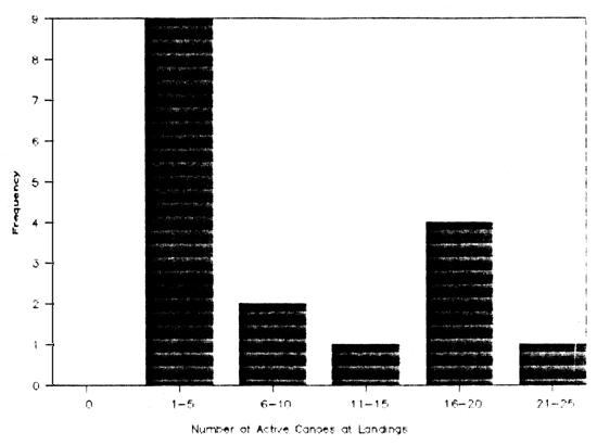
All the islands of the Lulamba Island Group were surveyed and a total of 17 landings were located (see Annex 3). All together 191 boats were enumerated of which 79.6 % were considered active. Non active boats accounted for 20.4 % of the total number of enumerated boats. The frequency of the number of active canoes for these landings are given in Fig. 3. Most of the active boats (96 %) in the Lulamba Complex were planked. The majority of these (90 %) were found to be fishing boats. Fishing boats also accounted for 94 % of the total number of active boats. The ratio of planked to dug-out fishing boats was 23 : 1. All powered boats were planked and constituted 34.9 % of the active boats. This figure is slightly less for powered fishing boats which constitute 32.9 % of the total number of fishing boats. Most transport boats (78 %) are powered. The mean number of fishing boats observed per landing was around 8 with an average of 3 crew per boat. Fish transport boats constituted a small fraction (5.9 %) of the active boats with an average of 2 crew per boat. The ratio of fishing boats to fish transport boats was 16 : 1.
Most of the landings (70 %) were already in existence by 1980. Access to most landings is by water only. The status of facilities available at the landings are given in Annex 4. None of these landings possess a fisheries office. There is also a complete absence of amenities/facilities such as piped water, out-board repair unit, shops biased or dealing in fisheries related goods, petrol station, etc. None of the communities at the landings have any co-operative undertaking (Table 1).
Fish handling facilities such as cleaning slab, display tables, drying racks and storage units for processed fish are non-existent in all the landings. Smoking is actually the predominant way of preservation of catches destined for the distant markets of Kasenyi and Katebo (Fig. 1). Smoking is done in 65% of the landings. Altogether 112 smoking units were enumerated with an average of 7 such units per landing (Table 2).
A small fraction of all active boats (6.8 %) were transporters (Kinara) specialised in transport of fish and fish-related products to the mainland markets. The number of intra-island transport facilities (bicycles, pick-ups) are generally poor (Table 3).
Almost all the respondents in landings of Lulamba complex (94 %) mention Kasenyi as their major market destination for their processed catches. For Katebo it is 53 %. The market destination of Kagonya on Lulamba Island proved to be a transit point to Kasenyi and Katebo since there was no market at this landing. The landings of Kyogal and Kafuna have what can be called “Non established markets for fresh fish” to serve peasant communities of nearby settlements (Table 4).
During 1989, accidents involving members of fishing communities of the islands were eight in all, claiming the life of 9 victims. Incidents of loss of gear and fish on the lake were similarly reported (Table 5).
4. Discussion & Conclusions
The number of landings per unit distance of shoreline was observed to be less -but with more canoes per landing- as compared to previous areas surveyed: the mean number of fishing boats per landing reported by Nyeko (1990) for an earlier survey around Northern Kome Complex was 5 which is comparatively less than the 9 for Lulamba. It can be argued that -in this case- the factor accounting for this difference is more linked to the less concentrated distribution of human settlements on the Lulamba islands than it is on the Kome Islands, the former having markedly fewer number of one-man type landings. Due to this, the survey conducted at Lulamba was easily carried out with no difficulty in locating respondents and less time spent in covering the whole group of Islands.
There were notably more powered boats as a fraction of active boats (34.9%) compared to the Kome figure of 18.9%. Most planked canoes were markedly large and virtually no dug-out canoes were observed. A type of planked canoe, locally known as “dinghy”, was classified as a dug-out. This was deemed appropriate because, though they were structurally planked, they were minute in size and had a functional capacity equal to the one for a dugout. Used for sheltered inshore Tilapia fishing, they sharply contrasted with the large planked canoes.
Most activities around the Islands revolve around fishing and smoking of fish. The number of people involved in smoking fish and related employment could not exactly be determined. General complaints of artificial low prices at beach markets as a result of manipulation by middle-men or “brokers” was noted as limiting to the profit margin and consequently the well-fare of these folks. More concerted effort towards co-operative undertaking could be a good way to counter the powers of these “brokers”.
Literature Cited
1. Nyeko, D. 1990. Report on the Trial Frame Survey Conducted around the Northern Side of the Kome Islands Complex (14–16 February, 1990). FAO/UNDP UGA/87/007 FISIN. STATDOC., No. 9
Fig. 1
SKETCH MAP SHOWING PLACES MENTIONED.
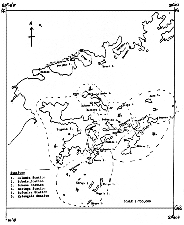
Fig. 2
SKETCH MAP OF LULAMBA COMPLEX.
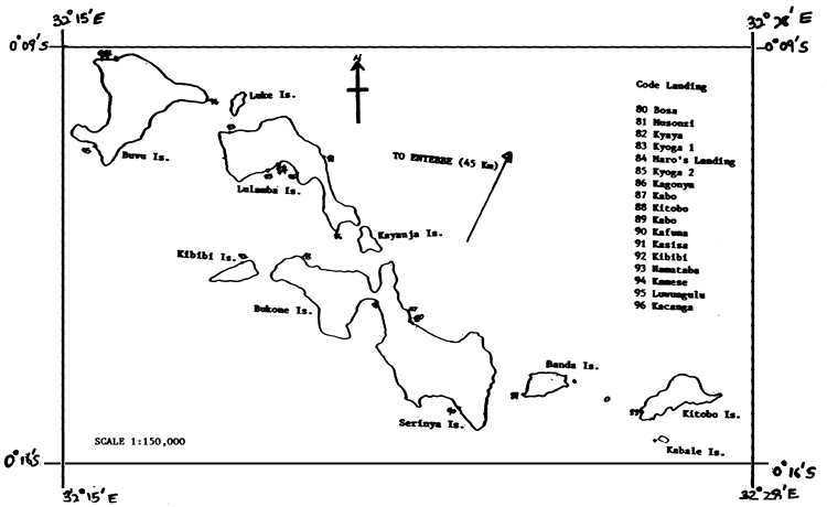
Fig. 3
Frequency of Number of Active Canoes
(AT SURVEYED LANDINGS)
ANNEX 1
TOUR ITINERARY AND LIST OF PERSONS INTERVIEWED.
ITINERARY
| 10th April 1990 | - | Departure from Entebbe |
| Bosa | ||
| Musonzi | ||
| Kyaya | ||
| Kyoga1 | ||
| Maro's landing | ||
| Kyoga2 | ||
| Kagonya | ||
| Kabo | ||
| 11th April 1990 | - | Kitobo |
| Banda | ||
| Kafuna | ||
| Kasisa | ||
| Kibibi | ||
| Namataba | ||
| 12th April 1990 | - | Kamese |
| Luyungulu | ||
| Kacanga | ||
| Return to Entebbe |
PERSONS INTERVIEWED
| Bosa | - | Miss. Rose Nalubega - Village Resident. |
| Musonzi | - | Mr. David Kabalu - Fisherman. |
| Kyaya | - | Mr. Francis Sembata - RC1 Chairman. |
| Kyoga1 | - | Mr. John Kajunge - Fisherman. |
| Maro' Landing | - | Miss. Harriet Najemba - Village Resident. |
| Kyoga2 | - | Mr. Joshwa Musizi - Fisherman. |
| Kagonya | - | Mr. Joseph Tesasira - RC1 Chairman/Fisherman. |
| Kabo | - | Miss Grace Nakyeteba - Village Resident. |
| Kitobo | - | Mr. J. Bazeketa - RC1/Chairman. |
| Banda | - | Mr. Wilson Katerega - Fisherman. |
| Kafuna | - | Mr. C. Mulindwa - Fisherman. |
| Kasisa | - | Mr. John Ssekindye - Fisherman. |
| Kibibi | - | Mr. Muhamed Ssasa - Fisherman. |
Annex 2
FISHIN PROJECT UGA/87/007
TRIAL QUESTIONNAIRE FOR FRAME SURVEY
| NAME OF RECORDER | DATE: |
| TIME: |
1. Name/Title Person Interviewed:
2. Landing Characteristics.
| Name of landing: | Name of parish: |
| Subcounty | County |
| District | Map code: |
| Nearest village | Km to main road (i.e. served by public transport) |
Access to landing: (tick)
Tarmac road Murram road Footpath Only by water
If landing is on island, specify name:
3. Staff Establishment.
| Landing staffed by: (Name/Designation) | , |
| , |
If NOT permanently staffed, is it ever visited by fisheries staff?
| NO | |
| YES | How often? |
| For what purpose? |
4. When was this landing established (since when in use)?
5. Is the landing used all year round? Yes No
- If YES, Do fishing operators also use any other landing(s)?
| NO | |||
| YES | Which landing(s)? | , | , |
| , | |||
- If NO; during which period(s) is it not used?
(Month) from (Month) to
Reason:
(Month) from (Month) to
Reason:
6. Is processed fish landed here? (Y/N)
If YES;
Type(s) ? Origin ? How often ?
Mode/number of transport ?
| 7. Number of non-active boats | : | |
Number of active boats | : | |
| TOTAL | : |
| ACTIVE BOAT CHARACTERISTICS | PLANKED CANOE (No.) | DUG-OUT | TRAWLER | ||
| Powered | Non Powered | No. | No. | ||
| TOTAL No. | |||||
| FISHING ONLY | |||||
| NO. CREW | Remarks: | ||||
| NO. OWNERS | |||||
| FISHING/TRANSP. | |||||
| NO. CREW | |||||
| NO. OWNERS | |||||
| TRANSP. ONLY* | |||||
| NO. CREW | |||||
| NO. OWNERS | |||||
* TRANSP. ONLY = FISH. TRANSP. + NON FISH. TRANSP.
8. Are the fisherfolk (operators and/or traders/processors) of this landing organised into any society/societies?
(Y/N)
If YES, Specify society name(s) and no. of members:
9. Market Destinations for Catch: Market at landing site? (Y/N)
Other markets (specify): ,
10. Facilities/Amenities at Landing only (No.)
| FEATURE/ SERVICE | NO. UNITS |
| Bicycle | |
| Pick-up | |
| Lorry | |
| Bus | |
| Van | |
| Wheelbarrow | |
| Weighing shed | |
| Cleaning slab | |
| Drying rack | |
| Smoking pit/Kiln | |
| Storage unit | |
| Frying unit | |
| Boat repair/const. | |
| Fish display table | |
| Fisheries office | |
| Petrol station | |
| Piped water | |
| Public latrine | |
| Net repair | |
| Outboard repair | |
| Fishing equip. shop |
11. Fishing risk:
For each landing, note the following particulars under the “General Remarks” section of the survey form.
During the calender year 1989, were any fishing/transport craft from this landing involved in any capsizing or sinking accidents? (Yes/No)
How many separate accidents occurred and how many craft from this landing were involved in each?
Was there any loss of life? If so, specify for each accident.
Was there any loss of property (Boats, Equipment, etc.)? If so, specify for each accident.
General Remarks:
Annex 3
RESULTS OF TRIAL FRAME SURVEY
LULAMBA ISLANDS COMPLEX
10th–12th April 1990
| Code | Landing | Number of Boats | Number of active Boats | Non active Boats | Powered Active Boats | Number Fishing Boats | Number Planked Fishing Boats | Number Dugout Canoes | Number Powered Fishing | Number Crew Fishing Boats | Number Transp. Boats | Number Crew Transp. Boats |
| 80 | Bosa | 3 | 3 | 0 | 0 | 3 | 3 | 0 | 1 | 6 | 0 | 0 |
| 81 | Musonzi | 25 | 22 | 3 | 13 | 20 | 20 | 0 | 11 | 71 | 2 | 6 |
| 82 | Kyaya | 10 | 8 | 2 | 0 | 8 | 8 | 0 | 0 | 16 | 0 | 0 |
| 83 | Kyoga | 3 | 3 | 0 | 0 | 3 | 3 | 0 | 0 | 6 | 0 | 0 |
| 84 | Maro's Landing | 1 | 1 | 0 | 0 | 1 | 1 | 0 | 0 | 2 | 0 | 0 |
| 85 | Kyoga 2 | 3 | 2 | 1 | 0 | 2 | 1 | 1 | 0 | 4 | 0 | 0 |
| 86 | Kagonya | 14 | 10 | 4 | 0 | 9 | 9 | 0 | 0 | 27 | 1 | 2 |
| 87 | Kabo | 3 | 2 | 1 | 2 | 1 | 1 | 0 | 1 | 4 | 1 | 2 |
| 88 | Kitobo | 25 | 20 | 5 | 16 | 18 | 18 | 0 | 14 | 68 | 2 | 4 |
| 89 | Banda | 19 | 16 | 3 | 12 | 16 | 16 | 0 | 12 | 48 | 0 | 0 |
| 90 | Kafuna | 7 | 5 | 2 | 1 | 4 | 4 | 0 | 0 | 12 | 1 | 3 |
| 91 | Kasisa | 3 | 2 | 1 | 0 | 2 | 2 | 0 | 0 | 4 | 0 | 0 |
| 92 | Kibibi | 7 | 3 | 4 | 1 | 3 | 3 | 0 | 1 | 9 | 0 | 0 |
| 93 | Namataba | 4 | 3 | 1 | 0 | 2 | 1 | 1 | 0 | 4 | 1 | 2 |
| 94 | Kamese | 22 | 18 | 4 | 4 | 18 | 18 | 0 | 4 | 48 | 0 | 0 |
| 95 | Luwungulu | 18 | 15 | 3 | 1 | 15 | 12 | 3 | 1 | 38 | 0 | 0 |
| 96 | Kacanga | 24 | 19 | 5 | 3 | 18 | 17 | 1 | 2 | 52 | 1 | 2 |
| Total | ||||||||||||
| 191 | 152 | 39 | 53 | 143 | 137 | 6 | 47 | 419 | 9 | 21 | ||
Annex 4
TABLE 1: FACILITIES/AMENITIES AT SURVEYED LULAMBA LANDINGS
| CODE | LANDING | Year open | Access lndng | Fshrs office | Piped water | Publc latrn | Boat yaro | Net rpr | Outprd rpr | F.Eqp shop | Petri stn | Coot soc | Soc mbrs |
| 80 | Bosa | -- | W | 0 | N | 1 | 0 | 0 | 0 | 0 | 0 | 0 | 0 |
| 81 | Musonzi | 1984 | W | 0 | N | 6 | 0 | 0 | 0 | 0 | 0 | 0 | 0 |
| 82 | Kyaya | 1988 | W | 0 | N | 0 | 0 | 0 | 0 | 0 | 0 | 0 | 0 |
| 83 | Kyogal | 1979 | W | 0 | N | 1 | 1 | 0 | 0 | 0 | 0 | 0 | 0 |
| 84 | Maro'landing | -- | W | 0 | N | 0 | 0 | 0 | 0 | 0 | 0 | 0 | 0 |
| 85 | Kyoga2 | 1970 | W | 0 | N | 0 | 0 | 0 | 0 | 0 | 0 | 0 | 0 |
| 86 | Kagonya | 1988 | W | 0 | N | 1 | 0 | 0 | 0 | 0 | 0 | 0 | 0 |
| 87 | Kabo | 1987 | W | 0 | N | 0 | 0 | 0 | 0 | 0 | 0 | 0 | 0 |
| 88 | Kitobo | -- | W | 0 | N | 0 | 0 | 0 | 0 | 0 | 0 | 0 | 0 |
| 89 | Banda | 1979 | W | 0 | N | 2 | 0 | 1 | 0 | 0 | 0 | 0 | 0 |
| 90 | Kafuna | 1987 | W | 0 | N | 0 | 0 | 0 | 0 | 0 | 0 | 0 | 0 |
| 91 | Kasisa | 1930 | W | 0 | N | 0 | 0 | 0 | 0 | 0 | 0 | 0 | 0 |
| 92 | Kibibi | 1960 | W | 0 | N | 1 | 0 | 0 | 0 | 0 | 0 | 0 | 0 |
| 93 | Namataba | 1910 | W | 0 | N | 0 | 0 | 0 | 0 | 0 | 0 | 0 | 0 |
| 94 | Kamese | 1950 | W | 0 | N | 3 | 0 | 0 | 0 | 0 | 0 | 0 | 0 |
| 95 | Luwungulu | 1950 | W | 0 | N | 0 | 0 | 0 | 0 | 0 | 0 | 0 | 0 |
| 96 | Kacanga | 1960 | W | 0 | N | 0 | 0 | 1 | 0 | 0 | 0 | 0 | 0 |
| Total | -- | -- | 0 | -- | 15 | 1 | 2 | 0 | 0 | 0 | 0 | 0 |
NOTE: “W” = Water only
“N” = Not Available
TABLE 2: HANDLING, PROCESSING & STORAGE FACILITIES AT SURVEYED LULAMBA LANDINGS
| CODE | LANDING | CLEAN SLAB | DISPLY TAB | PIPED WTR | DRY RACK | SMKNG UNT | FRY UNT | STRG UNT |
| 80 | Bosa | 0 | 0 | N | 0 | 0 | 0 | 0 |
| 81 | Musonzi | 0 | 0 | N | 0 | 20 | 0 | 0 |
| 82 | Kyaya | 0 | 0 | N | 0 | 5 | 0 | 0 |
| 83 | Kyogal | 0 | 0 | N | 0 | 1 | 0 | 0 |
| 84 | Maro'landing | 0 | 0 | N | 0 | 0 | 0 | 0 |
| 85 | Kyoga2 | 0 | 0 | N | 0 | 0 | 0 | 0 |
| 86 | Kagonya | 0 | 0 | N | 0 | 7 | 0 | 0 |
| 87 | Kabo | 0 | 0 | N | 0 | 0 | 0 | 0 |
| 88 | Kitobo | 0 | 0 | N | 0 | 24 | 0 | 0 |
| 89 | Banda | 0 | 0 | N | 0 | 15 | 0 | 0 |
| 90 | kafuna | 0 | 0 | N | 0 | 4 | 0 | 0 |
| 91 | Kasisa | 0 | 0 | N | 0 | 0 | 0 | 0 |
| 92 | Kibibi | 0 | 0 | N | 0 | 0 | 0 | 0 |
| 93 | Namataba | 0 | 0 | N | 0 | 2 | 0 | 0 |
| 94 | Kamese | 0 | 0 | N | 4 | 20 | 0 | 0 |
| 95 | Luwungulu | 0 | 0 | N | 0 | 7 | 0 | 0 |
| 96 | Kacanga | 0 | 0 | N | 0 | 7 | 0 | 0 |
| Total | 0 | 0 | -- | 4 | 112 | 0 | 0 |
TABLE 3: TRANSPORT FACILITIES AT SURVEYED LULAMBA LANDINGS
| CODE | LANDING | TRPT BT | BICYCLE | PICK-UP | LORRY | BUS | VAN | W/BARROW |
| 80 | Bosa | 0 | 0 | 0 | 0 | 0 | 0 | 0 |
| 81 | Musonzi | 2 | 0 | 0 | 0 | 0 | 0 | 3 |
| 82 | Kyaya | 0 | 0 | 0 | 0 | 0 | 0 | 0 |
| 83 | Kyogal | 0 | 1 | 0 | 0 | 0 | 0 | 1 |
| 84 | Maro'landing | 0 | 0 | 0 | 0 | 0 | 0 | 0 |
| 85 | Kyoga2 | 0 | 0 | 0 | 0 | 0 | 0 | 0 |
| 86 | Kagonya | 1 | 0 | 0 | 0 | 0 | 0 | 1 |
| 87 | Kabo | 2 | 0 | 0 | 0 | 0 | 0 | 0 |
| 88 | Kitobo | 2 | 0 | 0 | 0 | 0 | 0 | 0 |
| 89 | Banda | 0 | 0 | 0 | 0 | 0 | 0 | 0 |
| 90 | Kafuna | 1 | 0 | 0 | 0 | 0 | 0 | 1 |
| 91 | Kasisa | 0 | 0 | 0 | 0 | 0 | 0 | 0 |
| 92 | Kibibi | 0 | 0 | 0 | 0 | 0 | 0 | 0 |
| 93 | Namataba | 1 | 0 | 0 | 0 | 0 | 0 | 0 |
| 94 | Kamese | 0 | 0 | 0 | 0 | 0 | 0 | 0 |
| 95 | Luwungulu | 0 | 0 | 0 | 0 | 0 | 0 | 0 |
| 96 | Kacanga | 1 | 0 | 0 | 0 | 0 | 0 | 0 |
| Total | 10 | 1 | 0 | 0 | 0 | 0 | 6 |
TABLE 4: MARKET DESTINATIONS FOR SURVEYED LULAMBA LANDINGS
| CODE | LANDING | AT LANDING | Kasenyi | Katebo | Kagonya | Other |
| 80 | Bosa | Y | ||||
| 81 | Musonzi | Y | Y | |||
| 82 | Kyaya | Y | Y | |||
| 83 | Kyogal | Y | Y | Y | ||
| 84 | Maro'landing | Y | ||||
| 85 | Kyoga2 | Y | ||||
| 86 | Kagonya | Y | Y | |||
| 87 | Kabo | Y | Y | |||
| 88 | Kitobo | Y | ||||
| 89 | Banda | Y | Y | |||
| 90 | Kafuna | Y | Y | Y | ||
| 91 | Kasisa | Y | ||||
| 92 | Kibibi | Y | Y | |||
| 93 | Namata | Y | Y | |||
| 94 | Kamese | Y | Y | |||
| 95 | Luwungulu | Y | Y | |||
| 96 | Kacanga | Y | Y | |||
| 11.8 | 94.1 | 52.9 | 11.8 | 11.8 | ||
TABLE 5: WATER ACCIDENTS AT SURVEYED LULAMBA LANDINGS IN 1989
| CODE | LANDING | NO. ACDNT | DEATH | LOSS BT | LOSS GR | LOSS FSH |
| 80 | Bosa | 0 | 0 | |||
| 81 | Musonzi | 1 | 1 | |||
| 82 | Kyaya | 0 | 0 | |||
| 83 | Kyogal | 0 | 0 | |||
| 84 | Maro'landing | 0 | 0 | |||
| 85 | Kyoga2 | 0 | 0 | |||
| 86 | Kagonya | 0 | 0 | |||
| 87 | Kabo | 0 | 0 | |||
| 88 | Kitobo | 2 | 2 | |||
| 89 | Banda | 0 | 0 | |||
| 90 | Kafuna | 1 | 0 | Y | ||
| 91 | Kasisa | 0 | 0 | |||
| 92 | kibibi | 0 | 0 | |||
| 93 | Namataba | 1 | 1 | |||
| 94 | Kamese | 1 | 2 | Y | ||
| 95 | Luwungulu | 1 | 1 | |||
| 96 | Kacanga | 1 | 2 | Y | Y | |
| TOTAL | 8 | 9 |
![]()
![]()