![]()
![]()
There are numerous important global issues regarding inland capture fisheries. They arise from the facts that:
inland fisheries are extremely diverse in terms of their size, level of industrialization, reliance on enhancements, and time commitments of fishers;
they may cover a broad geographical range from high mountain lakes to coastal wetlands;
they are often practiced by the poorer and un-empowered levels of society, they are also practiced by very powerful members of society; and
they are one use of a valuable and often limited commodity - freshwater; mono-sectoral approaches to water use and management have been and continue to be common.
This section examines four areas of special importance at this time: i) inland fisheries as an undervalued resource due to the poor state of information on the sector - novel approaches to the improvement of inland capture fisheries statistics; ii) impacts on inland fisheries from current water-management plans - impact of dams on inland fisheries; iii) inland fisheries as a vital component of agriculture systems -fisheries of rice-based ecosystems; and iv) inland fisheries and indices of development and environmental sustainability. There are other important issues concerning inland fisheries that will be addressed in future revisions of Fishery Circular 942.
Background and introduction
There is consensus among those working on inland fisheries that they are extremely important, but that poor information on the status of the fisheries and the role they play in the economy of the region were preventing an accurate and comprehensive valuation of the sector[13]. For example, national estimates for the countries in the Lower Mekong Basin put inland fishery production at 834 962 metric tonnes with per capita freshwater fish supply of 10.8 kg/yr (FAO stat). More focused studies report 60 million people inhabiting the Mekong Basin, a production of 2.3 million metric tonnes, and a per capita fish consumption of 39 kg/yr. Many of the 60 million inhabitants engage in small-scale fishing or fish only part-time and represent some of the least empowered and poorest people in society. Clearly, discrepancies of this magnitude that concern such large numbers of people prevent proper valuation and management of the sector and must be addressed (Photo 1).
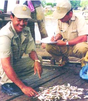
Photo 1: Cambodia fishery officers surveying dai fishery.
(Photo: Courtesy of Mekong River Commission Fisheries Programme)
The poor state of knowledge on these fisheries arises from the diverse nature of inland capture fisheries, the fact that the fisheries are often small scale and diffused over large areas, the fact that much of the harvest is bartered or consumed locally and is not registered as part of the formal economy of a region, the misconception that inland capture fisheries are of low value and not worth monitoring, the inadequate political power of many rural communities that rely on inland fishery resources, and the excessive power of certain stakeholders or sectors that do not want the true value of the resource known for personal or political reasons. In addition, official statistics are often based on estimates, which may not be based on actual data. Major sources of error in these officially reported statistics are:
deliberate misreporting;
lack of attention to small-scale fishing activities;
lack of status, capacity or training of local fishery officers;
errors in catch reporting (often field data is collected based on 'recall');
difficulty in accessing sources of information (women, children and other fishers far from population centres);
a reluctance to report catches because this is linked, in most countries, to licence fees or other forms of taxation.
What information is needed for decision making on inland fisheries?
The types of information needed will depend on the intended uses of that information, that is it will depend on the objectives of fishery management and the goals of water management policy. There are several possible objectives of inland fishery management that can be generally classified into social, economic, and conservation categories. Priority objectives for collecting information on inland fisheries include:
to obtain status and trend information on the fisheries and the environment for the formulation and assessment of management interventions concerning the fishery;
to ensure proper valuation of the fisheries;
to assess management interventions concerning the fishery;
to justify the requests for appropriate allocation of funding and other resources to the sector;
to fulfil international obligations.
Whereas the simultaneous fulfilment of some objectives, for example, use and conservation, may lead to conflict, most are not mutually exclusive and some fishery data may be appropriate for multiple objectives. Furthermore, there are layers of information needs:
1. to establish baseline information;
2. for trend analysis, i.e. monitoring the resource and impacts of management decisions; and
3. for specific objectives.
Approaches to improve information
In general, information collection methods in many areas are based on the application of traditional methods of government fishery officers assessing catch and effort data. However, these methods are best suited for formal, large-scale fisheries and are inadequate or inappropriate for the many informal, small-scale fisheries; many inland water bodies support both formal and informal fisheries, i.e. both large scale and small scale. Thus, alternative approaches are being developed and evaluated that attempt to include individual fishers, households, and communities. Additionally, indicators and proxy measures of fishery yield are being developed. Data alone are not always enough to manage a fishery or develop fishery policy. Data must be analysed and transformed into meaningful information and this information delivered in an appropriate form to the people who are actually making decisions that affect fisheries.
There are two general means to obtain information on inland fisheries:
1. direct measurement of the fishery through frame surveys, catch assessment surveys, census at landing sites, creel census, counting number of fishers, gears, boats, etc.; and
2. indirect measurements such as yield per type of habitat and extrapolation, GIS and remote sensing, post harvest surveys such as consumption, financial, trade and household surveys.
Direct measurement has not been adequate to represent the entire diversity of many informal or small scale inland fisheries and is best used for large-scale, managed fisheries. For many of the indirect strategies, participatory approaches that involve the stakeholders will be necessary to promote cooperation, information sharing and compliance with fishery management regulations.
Information collection systems must be flexible enough to accommodate the diversity of inland fishery data. There are already rigid, inflexible data collection systems in some areas and it would do little good to replace one for another.
Practical alternative approaches to information collecting are agricultural surveys, household surveys, consumption surveys, use of geo-referenced data coupled with habitat productivity estimates and fishery co-management. Each approach has strengths and weaknesses. Regardless of the approach used, training in survey techniques, participatory techniques and gender issues will be necessary to improve the quality of data collected.
Traditional catch and gear assessment surveys
These direct measurement methods are most appropriate for large-scale fisheries or where fishers must be licensed. Although difficult in many areas with diverse fisheries, in specific areas, species or fisheries could be targeted in order to obtain accurate information on a specific aspect of a fishery. Census of a fishery landing site surveys may be most feasible for large lakes and reservoirs. Tax and license systems can be used to provide information from certain fisheries, but this has not proved successful in some regions where licensing family and other small-scale informal fisheries is impractical. Problems in accessing accurate data may arise when fishers become too powerful or fisheries become too valuable which could lead to deliberate mis-reporting to avoid taxes or licensing fees.
Agriculture surveys
National censuses are being used to provide information on the agriculture sector. With the inclusion of appropriate fishery-related questions they could also be used to generate structural data and other economic and social information on inland fisheries, especially on their subsistence component. These censuses could also generate comprehensive listings of households engaging in fishing that could be used in sampling surveys. Currently, the structure, questions and terminology in many of the agricultural censuses lead to inaccuracies in regards to the fishery sector. Modifications will be necessary to provide useful inland fishery information. Generally, national surveys are an effective means to provide information on certain aspects of inland fisheries.
Some countries are adapting these surveys to meet the needs of the fishery sector. For example, the Lao People's Democratic Republic noted that the inclusion of one question on household expenditure revealed the important contribution of fish to overall consumption and corroborated the results of more detailed studies being undertaken in local areas. Viet Nam modified the household income expenditure survey to include the 'source of income'and discovered that nearly 70 percent of households engaged in some fishery and aquaculture activities. Although the potential use of censuses for collection of data and information on inland fisheries was recognized as useful, they are large-scale exercises. Processing the data often takes considerable time resulting in long delays in getting the information to resource managers.
Consumption studies, including house hold surveys
Household consumption studies are increasingly used to estimate regional or national consumption of fisheries products. Generally speaking, household consumption surveys were considered to be the most effective means of obtaining basin-wide estimates of the fishery in large and varied regions such as major river basins. It is clear that to obtain accurate information, good planning and control of survey design is essential. Specifically, effective consumption surveys require that surveys are designed to include appropriate geographic factors (e.g. marginal or transient communities), demographic factors (e.g. contributions from women, children and ethnic minorities) and that quality control of the data is incorporated into the design. Extrapolation of the consumption data to indicate fisheries yield in a particular area requires that import and export of fisheries products are also taken into account. These indirect measures are extremely useful for small-scale, informal fisheries. However, there are several potential sources of error including problems of recall, accessing appropriate information from women, children and other less empowered minorities and the problem of double counting data from market surveys that could affect accuracy.
Market surveys
For major fisheries, landing sites may be equivalent to markets; they are usually well known, not too remote and can be surveyed. Problems of double counting may occur as noted in the section on consumption studies since the same fish may be sold in numerous markets. Market studies can involve different aspects of fishery production, such as trade, export/import, food items, fish seed, quantity and value of fishery products. Market surveys may be useful for small-scale and widely dispersed fisheries. However, substantial quantities of fishery products are traded before going to market (ca. 17 percent from reservoirs).
Geo-referenced information
The use of Geographic information systems (GIS) and remote sensing information (RS) are increasing in fishery and ecosystems management (Kapetsky, 2000)[14]. However, there is the impression that these techniques are still expensive and difficult to implement locally. GIS are useful in predicting fishery potential and actual yields. They are also useful planning tools for creating models and "what if" scenarios. For example, "what would be the change in production if flooded forests were converted to rice-paddy (see below). It is also possible to find proxy measures for fishery production such as in China where plant coverage can be assessed by GIS and RS and then related to fishery yield. Validation of the accuracy of the predictions from such models will be necessary, as will training and capacity building.
Habitat classification and measurement
These approaches involve establishing fishery production values for specific habitats based on results of focussed studies. They are useful to establish a range of production values and potential, but not for routine monitoring. There may be problems with accuracy in estimating production from habitat classification. These techniques are especially useful when coupled with GIS/RS models. Focussed studies on particular habitats will be needed, plus demographic data will be necessary to evaluate potential effort and consumption.
Co-management or fishery user groups
These techniques attempt to include the users in the data collection and fishery management process. The in situ management structure of some habitats/fisheries can provide the means to collect information. Fishing companies have been created in China that manage lake and reservoir fisheries and provide data to government resource officers. Related to market studies, intermediate buyers and sellers of fishery products also provide an entry point to access information on a fishery. Lake Victoria in East Africa provides an example of a co-management system that has improved the quality of information on a lake fishery. Such co-management and fishing associations promote cooperation between community and government regulators and provide a good means for communities to collect and collate information. Family logbooks can also be incorporated into fishery co-management.
Conclusions
Given the nature of inland fisheries and the ecological and human environments of inland water ecosystems, it is understandable why accurate information is difficult to obtain.
In light of the large number people involved directly in fishing or in flow-on activities such as processing and marketing and sales, small errors in estimation multiplied by the numerous people involved lead to gross errors in overall production. The acceptable level of accuracy in estimating production and value of inland fisheries will depend on what is being analysed. For global estimates, less accuracy will be required than for local planning and fishery management.
Member countries are encouraged to submit data on inland fishery yield, species, effort and consumption to FAO. However, the primary reason for countries collecting fishery data is to help in the development of national fishery management and wetland policy. It appears that much of the information reported to FAO is actually not being used for these purposes and that the reason for collecting information on inland fisheries is not well known by national fishery resource officers, fishers, or the local communities that rely on inland fisheries. The objectives for collecting information on inland fisheries needs to be specified and conveyed to users along with the benefits of having accurate information.
Yield is a primary information need. There are direct methods to measure yield, but these are difficult to apply to the entire inland water ecosystems that include lakes, temporary water bodies, rivers, swamps and other wetlands. Therefore, alternative approaches will be required to supplement direct measures of fishery yield.
Inland fisheries are extremely diverse and composed of both formal and informal fishery sectors that must be treated differently. Methodologies that work in one area may be inappropriate for others. A certain amount of standardization of terminology, approaches and methods will be essential for basin-wide planning and information exchange, however, it is recognized that the diversity of situations will require a diversity of approaches.
Given limited human and financial resources to manage inland fisheries one cannot measure everything that is needed in all areas. Thus, focussed studies can provide information on particular fisheries or habitats and these results can then be extrapolated to a wider area. An ongoing and sustainable data collection programme needs to be based on activities that can be done well with a limited amount of financial and human resources.
Inland fisheries and fishing activity often have a strong seasonal component. Data collection and interpretation must take into account how habitats, production, and human activity change in response to the changing environmental conditions.
The capacity of local fishery resource officers needs to be increased. Training in standard and new data collection, fish identification and community participation techniques will be required. The status of government fishery officers is often very low and leads to lack of motivation, which results in poor performance of duties. Once the importance of inland fisheries is fully appreciated, the status of the officers responsible for managing the resource should improve.
There are data collection systems in place. Significant progress can be made by working with information that is already available in project reports, government offices, NGOs and IGOs. Modification of existing mechanisms to make them more flexible, to ensure they do not bias results in regards to inland fisheries, such the agriculture census, or to ensure that they access all available information, such as information from women and children, can be expected to greatly improve the quality of information needed for fishery management.
Inland fisheries do not exist in isolation of other sectors and there are many other users of inland water resources. Inland waters are most strongly impacted by events occurring outside the sector. Therefore, it will be crucial for policy makers and managers of the inland fisheries to form partnerships with stakeholders in other sectors. Often government departments can help form linkages to other sectors where fishers have difficulty in establishing relations. The private sector must also be involved in the partnership, for example access to middlemen and brokers could improve information on commercial (formal) fisheries.
Many member countries have limited financial resources and have acknowledged that external assistance will be needed to improve their data collection and fishery management capacities. Training is needed on a variety of subjects and should include local communities and training-of-trainers. Given the productivity of the inland fisheries, the large number of people dependent on them and the wealth of biological and cultural diversity of many inland aquatic ecosystems, donor support in improving information for fishery management is well justified.
G. Marmulla, Fishery Resources Officer
Inland Water
Resources and Aquaculture Service (FIRI)
Introduction
Construction of dams and weirs for irrigation, hydropower generation or flow management has a long tradition in many parts of the world. Over the second half of the last century, many thousands of large dams have been constructed world-wide. The number of existing smaller dams, weirs and other in-stream obstacles across rivers is not known on a global scale but is probably in the order of several hundred thousands. The construction of barriers across rivers has negative impacts on the natural fish populations and contributes to a large degree, together with other factors, to the diminished abundance, disappearance or even extinction of species. LARS2 identified dams and the disruption of ecological flows in rivers and floodplains as a major factor in the decline of inland fisheries. One of the best known examples in the first half of the twenty century was the extinction of the salmon (Salmo salar, L.) in the River Rhine where once there was a thriving fishery. However, there are many more examples of threatened species globally. When looking deeper into the issue, one realizes that not only species in Europe and North America are concerned but also in other continents. Unfortunately, for most of the non-European and non-North American species far less is known regarding their biology and behaviour, and far less reliable information on catches and population dynamics is available. The international community is slowly becoming aware of the value of living inland aquatic resources as evidenced by the European Union Water Directive, the World Water Forum, the high priority awarded to it by the Convention on Biodiversity, the decommissioning of dams in North America and Europe, and the reestablishment of keystone species such as salmon through large scale rehabilitation of some damaged rivers. However, inland fisheries would merit to receive even a higher profile than that attributed to it by the World Summit on Sustainable Development.
Issue
Although no encompassing generalization can be made, dams have been constructed more recently in developing than in developed countries, and their number is expected to increase in developing countries at a faster pace because of fast population growth, and currently unsatisfied and fast growing needs of water-resources users. Except for recreational fisheries, inland catches are higher in developing countries, where they also have a proportionally much greater economic and nutritional importance.
Both diadromous and potamodromous species are essential to inland fisheries in many developing countries, both in temperate and tropical regions, and the life cycle of these species has been, or is expected to be, compromised unless some efforts are made to restore or preserve the longitudinal connectivity, and thus their migration along rivers.
Despite its utmost importance to fisheries and biodiversity, the issue of preserving or rehabilitating fish passage is not systematically perceived as a priority in terms of economical and social benefits. The negative impact of dams on fisheries and livelihoods is not always noticed immediately because of some other benefits of dams, the resistance of the concerned fish species in the short-term, or temporary increase in catches as a result of stocking in reservoirs and blockage of migrants below dams. However, there is evidence that the majority of large dams have led to a decline in fisheries and associated activities. Additionally, there have been dramatic examples of how the blockage of fish migrations and habitat modifications resulting from damming impacted entire ecosystems through modifications in the structure of the food web of, for instance, piscivorous birds and mammals that heavily rely on migratory species (Photo 2).
There is a growing awareness of these issues worldwide, but it has not reached the same level in most developing countries as in developed countries. This is partly due to past or prevailing deficiencies of educational systems. Additionally, this awareness is generally compromised by the fragmentary knowledge of the ichthyofauna, migration histories, and structure of food webs in developing countries, especially in the tropics. Knowledge on environmental engineering is also lacking. This raises crucial issues about the willingness of stakeholders to invest into ways of preserving and restoring longitudinal connectivity, and this is further complicated where funding is scarce or legislation is not compulsive, especially for modifying existing obstacles.
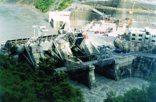
Photo 2: The dam of the Kali Gandaki "A" Hydroelectric Project in Nepal (still under construction when the photo was taken in July 2001) is a typical example of an obstacle that blocks the migratory route of fish species that are important for the river fisheries as no fish pass was constructed for upstream migration. (Photo: G. Marmulla)
Impacts
Dams can have important negative impacts for fisheries, especially in tropical regions where rivers often sustain important fisheries. Yield models for large rivers, where river basin area and length of the main channel have been related to catches, suggest exponential increases with increasing river length (Welcomme, 1985) due to the connectivity and cumulative influences of upstream processes within the system ("River Continuum Concept": Vannote et al., 1980) and lateral processes associated with riparian, watershed and floodplain dimension of the stream ecosystem ("Flood Pulse Concept": Junk, Bayley and Sparks, 1989). Where rivers have extended floodplains, the fish production is even higher. Along the stream continuum, dams and their associated upstream reservoirs have downstream effects on riverine environments and, subsequently, diverse influences on downstream fisheries, even beyond the lotic ecosystem. Cumulative effects of dams in catchment basins and tributary streams can significantly block nutrient flow throughout the ecosystem, affecting fisheries production in downstream reservoirs (Welcomme, 1985), river channels (Hess et al., 1982) as well as estuary and marine environments (Ryder, 1978). Compensation for loss in yield from river fisheries can be difficult to achieve through development of reservoir fisheries. The larger the river, and the more downstream the location of the dam, the less the potential there is for a reservoir fishery to compensate in terms of yield for losses sustained by the river fishery. Compensation potentials apparently are higher in shallower reservoirs in tropical regions than they are in deeper reservoirs and in more northern latitudes.
There exist examples of productive reservoir fisheries that have been seen developing with yields of up to 329 kg/ha/yr in small reservoirs in Africa (Marshall and Maes, 1994), up to 125 kg/ha/yr in Latin America and the Caribbean (Sugunan, 1997) and up to 650 kg/ha/yr in Asia (Sugunan, 1997). Thriving reservoir fisheries can also develop where river fisheries originally contribute little to overall national fishery yields or in drier regions where dams are constructed for irrigation, and fisheries are secondary considerations. Benefits seem more pronounced for smaller, shallower reservoirs. Stocking of exotic species (both in reservoirs and in tailwaters) can enhance yields, as long as stocking is done in accordance with existing guidelines and regulations and the exotic fishes are environmentally sound and culturally acceptable to the target human population. In this regard, caution is warranted in cultures where fishing and fish consumption are non-traditional activities. Building reservoirs in the context of such cultures may not achieve projected fishery benefits even though exploitable fish stocks may exist.
However, even if compensation is achieved from a fishery perspective, specific needs of fish species not included in the fishery but threatened or endangered must be considered to avoid negative impacts to these fishes.
Impairment by cross-river structures is of two main types. At first, they constitute barriers to upstream and downstream migration for most of the species which, during a certain phase of their life cycle, depend on longitudinal movements in the river, and secondly they affect species through the morphological modifications that result from the damming. These physical modifications are of a wide range and usually include a change in slope, river bed profile, structure of the bottom surface, bottom substrate, submersion of gravel zones or riffle sections, as well as the destruction of riparian vegetation and changes in the thermal or trophic regime. Very often the downstream flow regime is drastically changed (Photo 3).
People are tempted to believe that low weirs or cross-river sills are not serious obstacles but it is not so much the absolute height of the construction that matters but rather the effect these barriers have on the local species. Even if an obstacle is rather low (a couple of decimetres to a few meters) it can have devastating effects depending on the swimming capacities of the fish species concerned. Nowadays, concern is expressed not only with regard to fish species but all aquatic animals (or aquatic life stages of animals, e.g. macrozoobenthos) that depend on free longitudinal movements in the river (Photo 4).
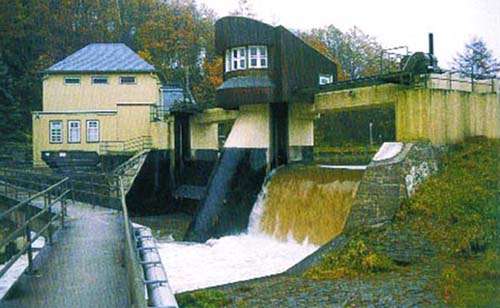
Photo 3: Dams and weirs, regardless of their height, block fish passage if not equipped with well-functioning fish passage facilities for upstream and downstream passage. The photo shows the weir of a hydropower station on a tributary to the river Rhine where Atlantic salmon once was common. (Photo: G. Marmulla).
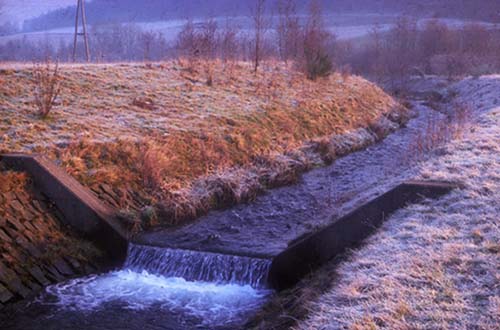
Photo 4: Even low cross-river sills can constitute obstacles depending on the swimming capacities of the fish species concerned. (Photo: G. Marmulla).
It is important to note that not only the so-called "migratory species" (i.e. the typical long-distance migrators like salmon, sea trout, shad) are affected by obstacles but all species that, for feeding or spawning purposes, change position within the river system during their growing period, and this is independent of the distance they cover. Longitudinal passage might be completely interrupted or, at least, migration be delayed. Very often, managers only think in terms of interruption of upstream migration but in most circumstances also downstream passage is impaired and mortality can result from downstream passage through hydraulic turbines or over high spillways. This is particularly problematic for adult eel migrating downstream. Furthermore, increased predation on migrating young fish, e.g. when passing through the reservoir, must not be underestimated. The cumulative effect of several obstacles on the same river has also to be taken into account.
Actions - solutions
While obstructed passage can, at least to some extent, be mitigated through a variety of well-functioning passage facilities, i.e. fishpasses (nowadays also called "fauna passes") for upstream migration and bypasses for downstream passage, lost habitat (see the second type of impairment mentioned above) can not easily be compensated for. As regards fishpass construction, there is long and good experience in North America and Europe. Some countries, e.g. France, have amended the relevant laws to include the obligation to restore free passage at obstacles, at least on classified rivers that are important for migratory species. Increasingly, the "Polluter-Pays Principle" (or "User-Pays Principle") is applied, i.e. the owner of the dams and weirs has to pay to restore free passage. Over the last two decades, tremendous progress, especially in France, has been made to improve the fish passage facilities, first for upstream and now also for downstream passage. Most recently, a vertical slot fishpass has been constructed at the Iffezheim Dam on the River Rhine to allow salmon and other species to migrate again upstream and recolonize the former habitats (Photo 5).
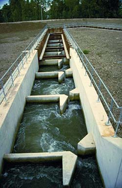
Photo 5: The vertical slot fish pass at the Iffezheim dam is an example of a recently built fish pass facility on the river Rhine. Together with the sophisticated entrance construction (i.e. several entrances to attract fish towards the pass), the 37 pools help fish to pass the 10 m high obstacle (Photo: M. Larinier).
A prerequisite for the construction of effective (qualitative concept) and efficient (quantitative concept) fish passage facilities is the knowledge of the biology and behaviour of the species concerned. This is what makes transposing of fish passage technology to dam projects in other continents difficult as often basic biological information (especially on their behaviour at obstacles) is missing. If then design standards developed for fish of temperate zones are blindly applied to tropical conditions, failure is quite likely to occur. However, limited knowledge of the biology must not lead to "do nothing". On the contrary, the precautionary approach (FAO, 1997), i.e. construct the best possible fish pass based on existing knowledge, should be applied as was also discussed at a Workshop on "Fish passage in developing countries" held in Cape Town, South Africa, in 2002, of which a summary (Marmulla, Kairys and Baras, 2002) is available at: http://www.southernwaters.co.za/sw/downloads.php?id=20.
The fishway should be built based on local characteristics but its planning should ideally be placed into a river basin context, or even into a broader context wherever the authority that defines priorities for this issue has the responsibility for several catchments. Of particular concern is the issue of river catchments that are shared by neighbouring countries, and for which transnational coordination is highly desirable, e.g. Mekong River Commission, International Rhine Commission, International Elbe Commission. Interdisciplinary decision advisory groups have a vital role in helping to find consensus and appropriate solutions, especially with regard to large migration restoration projects. Capacity building, as well as knowledge and technology transfer, could be greatly facilitated through workshops and consultation of experts. Coordination between groups is also highly desirable in order to share experience on the functioning of fishways, avoid the replication of errors, and compile or collect information on the migratory behaviour of fish species that are poorly documented.
Information is more particularly needed on the seasonal and daily periodicity of migration, and on the environmental cues to fish migration, so that flows and dams can be managed in a fish-friendly way. Ideally, this should be achieved all year round but, when the use of water resources is a matter of competition (or sometimes conflict) between users, a compromise can be found by prioritising those periods of the year when the maintenance of certain flows is essential.
Fish pass design involves a multidisciplinary approach. Engineers, biologists and managers must work closely together. Fish passage facilities must be systematically evaluated, if possible through a comprehensive long-term monitoring programme. It should be remembered that the fishpass operation is based on empirical information, i.e. based on feedback from experience, and that the most significant progress in fish passage technology has been made in countries where the effectiveness of the passes was systematically assessed and where it was obligatory to provide monitoring results.
Effective environmental assessment and management coupled with improvements in design of civil engineering structures has made some recent dam projects more fish friendly and environmentally acceptable but there is still an urgent need for drafting legal instruments on a wider scale which will facilitate modification of dam structures to incorporate mitigation measures, including monitoring, and help altering dam operation rules to be more beneficial to fish biodiversity and fisheries.
The FAO Fisheries Department, through its Inland Water Resources and Aquaculture Service (FIRI), has a Regular Programme activity to evaluate the interactions of human-induced modifications of the environment and the fisheries and to provide advice on rehabilitation of inland fisheries habitats, including free passage at dams. In this framework, FIRI has published in 2001 a Technical Paper on Dams, fish and fisheries (FAO, 2001) in which most of the information provided above has been
discussed in greater depth. The four contributions contained therein have been compiled as working papers for the World Commission on Dams (WCD) in their process of reviewing the various impacts and benefits of dams while preparing the global report on "Dams and Development". FAO projects and field activities to help restoring the migration routes of species that are of importance for the fisheries have been successfully implemented or are under way. Among the countries that have benefited, or currently benefit, from technical advice provided by the FAO Fisheries Department, either directly or through consultants, are Estonia, Lithuania, South Africa and Thailand. Other countries are interested and might soon put forward a request in this respect.
Literature cited
FAO. 2001. Dams, fish and fisheries. Opportunities, challenges and conflict resolution, by G. Marmulla. FAO Fisheries Technical Paper No. 419. Rome.
FAO. 1997. Inland fisheries. FAO Technical guidelines for responsible fisheries No. 6. Rome. 36 pp.
Hess, L.W., Schlesinger, A.B., Hergenrader, G.L., Reetz, S.D. & Lewis, H.S. 1982. The Missouri River Study - Ecological Perspective. In: L.W. Hess, G.L Hergenrader, H.S. Lewis, S.D. Reetz & A.B. Schlesinger, eds. The Middle Missouri River. Missouri River Study Group. pp. 287-301. Lincoln, Nebraska, USA, Nebraska Game and Parks Commission. 301 pp.
Junk, W.J., Bayley, P.B. & Sparks, R.E. 1989. The Flood Pulse Concept in River-floodplain Systems. In: D.P. Dodge, ed. Proceedings of the International Large River Symposium. Canadian Special Publication of Fisheries and Aquatic Sciences No. 106. Ottawa.. pp. 110-127.
LARS2 - www.LARS2.org.
Marmulla, G., Kairys, A. & Baras, E. 2002. Fish passage in developing countries: issues and perspectives. Summary of the Workshop on Fish passage in developing countries, 2002, Cape Town, South Africa. http://www.southernwaters.co.za/sw/downloads.php?id=20.
Marshall, B. & Maes, M. 1994. Small Water Bodies and their Fisheries in Southern Africa. CIFA
Technical Paper No. 29. FAO, Rome. 68 pp.
Ryder, R.A. 1978. Fish Yield Assessment of Large Lakes and Reservoirs - a Prelude to Management. In: S.A. Gerking, ed. Ecology of Freshwater Fish Production, pp. 403-423. London, UK, Blackwell Scientific Publications.
Sugunan, V.V. 1997. Fisheries Management of Small Water Bodies in Seven Countries in Africa, Asia and Latin America. FAO Fisheries Circular No. 933. FAO, Rome. 149 pp.
Vannote, R.L., Minshall, G.M., Cummins, K.W., Sedell, J.R. & Cushing, C.E. 1980. The River Continuum Concept. Can. J. Fish. Aquat. Sci., 37: 130-137.
Welcomme, R.L. 1985. River Fisheries. FAO Fisheries Technical Paper No. 262. FAO, Rome. 330 pp.
|
Glossary (after: Armantrout, N., 1998. Glossary of aquatic habitat inventory terminology; and FAO, 1998. Rehabilitation of rivers for fish). Anadromous: a life history strategy of fish that includes migration between freshwater and saltwater (sea); reproduction occurs in freshwater while growing to adult stage occurs in the ocean. Flood pulse concept: floodplains and floods are regarded as essential components of fluvial systems as many floodplain rivers derive a substantial percentage of their biomass from within the floodplain, i.e. lateral exchanges between floodplains and the river channel and nutrient recycling within the floodplain. Lentic: an aquatic system with standing or slow flowing water (e.g. lake, pond, reservoir, swamp, marsh and wetland) and nondirectional net flow of water. Lotic: aquatic system with rapidly flowing water such as a brook, stream or river where the net flow of water is unidirectional from the headwaters to the mouth. Potadromous: life-cycle strategy of a fish that includes migrations, spawning and feeding entirely in freshwater. River continuum: ecological succession that occurs from the headwaters to the mouth in a river and that is associated with an increase in nutrients and organic matter. |
M. Halwart, Fishery Resources Officer (Aquaculture)
Inland Water Resources and Aquaculture Service (FIRI)
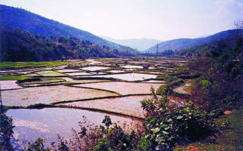
Photo 6: Rice-based ecosystems often represent a dynamic and closely linked complex of rice fields, ponds, irrigation canals, and rivers (Viet Nam). (Photo: FAO/M. Halwart)
Introduction
The cultivation of most rice crops in irrigated, rainfed and deepwater systems offers a suitable environment for fish and other aquatic organisms. Over 90 percent of the world's rice, equivalent to approximately 134 million hectares, is grown under flooded conditions providing not only home to a wide range of aquatic organisms, but also offering opportunities for their enhancement and culture. Aquatic production, in addition to the rice crop itself, is a critically important resource for rural livelihoods in developing countries; its local consumption and marketing are particularly important for food security as it is the most readily available, most reliable and cheapest source of animal protein and fatty acids both for farming households as well as for the landless. The purpose of this paper is to synthesize recent information and highlight the important role that rice-based aquatic products play in rural livelihoods. This information is not commonly available but crucial for informed policy decisions. The time for emphasizing the importance of rice associated aquatic biodiversity is particularly relevant in view of the forthcoming UN International Year of Rice 2004[15].
The issue
Aquatic production other than rice obtained from rice-based ecosystems and its importance for rural livelihoods is generally underestimated and undervalued (FAO/MRC, 2003; Halwart, 2003) because the local consumption or marketing usually prevents this production from entering official national statistics. Additionally, the availability of this production is temporally and spatially variable, and the quantity of captured, collected, or farmed organisms is usually small. Rice is generally viewed as a monoculture and considered the key commodity for local and national food security. Thus, emphasis in national crop production strategies is usually placed on enhancing rice yields which in turn often leads to increased fertilizer and pesticide inputs.
Policy makers must base their decisions on sound information. Yet, the information they require in regard to ricefield fisheries and rice-based aquaculture is usually not available and, therefore, the contribution these resources make to rural livelihoods is not recognized. Development plans that only focus on increasing yields of rice may possibly give the people more rice to eat, but may at the same time take away much of the aquatic animals and plants also harvested from and around the rice fields. Without a sound understanding of the other components of the ricefield ecosystem and careful consideration of suitable extension there is a great risk that the aquatic animal and plant diversity can be severely affected. Importantly, it will be the poorer segments of rural society which will suffer most from the negative impacts of such development.
From fisheries to aquaculture - a continuum
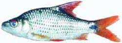
Rice-fish systems can be separated into capture or culture systems depending on the origin of the fish stock. All these systems are referred to under the term "rice-based systems" or "rice-fish systems", since the farm economy within which aquaculture takes place is usually dominated by rice cultivation. In the capture system wild fish enter the rice fields from adjacent water bodies and reproduce in the flooded fields. Rice fields may also be deliberately stocked with fish either simultaneously or alternately with the rice crop, this is also known as concurrent and rotational rice-fish farming (Photo 7). The rice fields may be used for the production of fingerlings or table fish depending on the size of fish seed available for stocking, the duration of the fish culture period, and the market needs for fingerlings or table fish (Halwart 1998, Demaine & Halwart 2001).
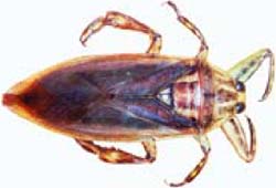
Rice field ecosystems have a rich aquatic biodiversity that is extensively used by the local people (Photo 8). The most important group, in terms of species diversity and importance for the local people, are the fishes. Atotal of 70 and 52 different fish species were found by Balzer, Balzer and Pon (2002) in Cambodia and by Luo (in press) in China (Table 1). In addition to fish, many species of crustaceans, molluscs, amphibians, insects, reptiles, and aquatic plants are listed totalling over 100 species with nutritional, medicinal, decorative and other uses (Balzer, Balzer and Pon, 2002) (Table 2).
Many fish species can be harvested from rice fields but in the culture system only few are commercially important - among the most common and widespread are common carp and Nile tilapia. They feed low in the food chain and are therefore preferred species in the culture systems (Photo 9). Other popular species are Puntius gonionotus and Trichogaster spp. Many air-breathing species such as the snakehead Channa striata or catfishes Clarias spp. are well adapted to the swamp-like conditions of rice fields. They are highly appreciated wild fish in the capture system as they fetch good market prices, but less appreciated in the culture systems as they can decimate the stocked fish significantly[16].
Traditionally a good deal of the fish for household consumption was caught from the paddy fields. With increased fishing pressure, the conversion of many wetlands into agricultural land, and the intensification of rice production, the ricefield fishery has declined in many areas and farmers have often turned to aquaculture as an alternative source of animal protein.
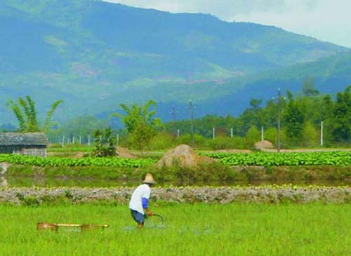
Photo 7: Both concurrent and rotational rice-fish farming are practiced in southwest China. In some rice fields, the stubbles remain in the field after the rice harvest. The ratooning plants are regularly cut and fed to grass carp (Photo: FAO/M. Halwart)
Table 1: Aquatic species (number) collected from rice-based ecosystems and used by rural households
|
|
Cambodia |
China |
|
Fish |
70 |
52 |
|
Crustaceans |
6 |
2 |
|
Molluscs |
1 |
4 |
|
Amphibians |
2 |
4 |
|
Insects |
2 |
3 |
|
Reptiles |
8 |
- |
|
Aquatic Plants |
13 |
19 |
Source: Balzer, Balzer, Pon, 2002; Luo, in press.
Note: Specimens were identified to species level, as possible.
Table 2: Indicative list of uses of various aquatic organisms from rice fields
|
Taxon |
Scientific Name |
Uses |
|
|
Fish |
Cyclocheilichthys sp. |
Fresh; fermented fish paste; fermented fish pieces; dried salted fish; fish sauce |
|
|
Reptile |
Erpeton tentaculatum |
Medicinal use |
|
|
Amphibian |
Bufo melanostictus |
Fresh; medicinal use (anthelmintic) |
|
|
Crustacean |
Somanniathelphusa sp. |
Fresh; feed; bait |
|
|
Mollusc |
Pila sp. |
Fresh; feed; bait; sale |
|
|
Plant |
Nelumbo nucifera |
Flowers, leaves, seeds, rhizome for consumption, sale, decoration and wrapper |
|
|
Insect |
Lethocerus sp. |
Fresh; medicinal use |
|

Photo 8: Rice-based ecosystems are often modified to enhance the production from a rich and diverse biodiversity (Viet Nam). (Photo FAO/M. Halwart)
Ecological functions
Many of the aquatic organisms found in rice ecosystems play an important role as biological control agents of vectors and pests of medical and agricultural importance and are an important element of Integrated Pest Management (IPM). Fish that are specialized to feed on mosquito larvae or on particular snail species may control vectors of malaria and schistosomiasis. Some fish species contribute to the biological control of rice pests such as apple snails, stemborers, or caseworms (Halwart, 1994; 2001). Fish also feed on weeds and other insects thereby reducing potential pest problems and maintaining the ecosystem balance. In fact, biological control has been proven to be more profitable than prophylactic or threshold-based pesticide treatments (Rola & Pingali, 1993). Moreover, farmers have experienced that the concurrent culture of fish with rice often increases rice yields, particularly on poorer soils and in unfertilized crops, probably because under these conditions the fertilization effect of fish is greatest. With savings on pesticides and earnings from fish sales, increases in net income on rice-fish farms are reportedly 7 to 65 percent higher than on rice monoculture farms (Halwart, 1999).
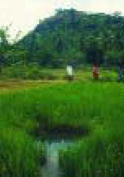
Photo 9: Arefuge for the fish is usually provided in rice fields (Sri Lanka). (Photo: FAO/M. Halwart).
Rice fields may also harbour species which are under threat of extinction. The deepwater rice ecosystem and the adjacent flooded grass and shrub lands near the Tonle Sap, Cambodia, are habitat for many birds, among them the bengal florican, an endangered species of which only two populations remain worldwide (Smith, 2001). The use of some endangered species, as is the case for Ichthyophys bannanicus (Photo 10) which has medicinal value, in the long term is probably a blessing, since it is the economic value which may lead to its cultivation thus ultimately ensuring the survival of the species.
Recent activities
The high availability of wild fish usually favoured the development of the capture system in the rice fields associated with flood plains of large river systems. This system has been studied recently with regard to the living aquatic resources availability and use pattern of rice farmers in the Upper and Lower Mekong River flood plains in Xishuangbanna, Yunnan Province, China (Luo, in press) and in Kampong Thom Province, Cambodia (Balzer, Balzer, Pon, 2002). A relatively lower availability of wild fish in remote mountainous areas resulted in the emergence and evolution of the culture rice-fish system. Indigenous rice-fish systems using locally adapted strains of fish species are found in the uplands of northern Viet Nam and the Lao People's Democratic Republic. The traditional knowledge in these rice-fish societies has been the particular focus of recent work in the Vietnamese Provinces of Hoa Binh, Son La and Lai Chau (Meusch, in prep.), and the Laotian Provinces Xieng Khouang and Houa Phanh (Choulamany, in prep.).
Photo 10: Ichthyophys bannanicus, an endangered amphibian with medicinal value endemic to Southwest China, is found in irrigated rice systems in Xishuangbanna, China. (Photo: FAO/A. Luo)
Productive ecosystem under threat
The availability of aquatic resources in rice fields is declining. While the amount of aquatic organisms consumed has remained constant, a decade ago rice-based capture supplied half of this consumption, nowadays only one-fifth to one-third is derived from capture in rice-based farming and the remainder has to be bought or farmed (Luo, in press; Photo 11). Farmers in Xishuangbanna claimed that fish are becoming less and less abundant, and that the amount of aquatic organisms collected in one day nowadays is equivalent to what was collected a decade ago in one hour. Similarly, the Cambodian study points out that fish catches have greatly reduced over the past two decades. The villagers estimate that in three to five years there will not be enough fish to make a living. Human population increase and the consequent increased fishing pressure on aquatic resources is an important factor in the decline of living aquatic resources, and a number of related activities are also responsible: pesticide use, destruction of fish breeding grounds, and illegal fishing tools such as electro-fishing or chemical poisoning do not allow fish populations to maintain themselves. Development efforts urgently need to address these threats.
It is particularly the rural poor who are often highly dependent on the aquatic biodiversity in rice fields. They may not have access to money but in many areas they still have access to the biodiversity that supports them. Particular threats to them are the destruction of the fishery resources through overexploitation by industrial capture fishery and the restriction of access to the fishery resources, for example when fishing grounds are leased to commercial fishery companies as fishing lots. These poor people will be hit hardest since they have no land to cultivate and completely depend on the capture of wild resources.
Looking forward
The findings of these recent studies allow an increased understanding and appreciation for the rich diversity and value of aquatic resources, the local practices related to their capture and culture, and the need to work closely with farmers to develop appropriate interventions for aquaculture production. Making this rice-based aquatic biodiversity visible has had first policy implications at international level (see Box next page).

Photo 11: Aquatic organisms caught and cultured in rice-based farming systems are part of the daily meal; the surplus is conserved or sold at the local market (China). (Photo: FAO/A. Luo)
However, more efforts particularly at country level are needed. Activities planned by local institutions in Cambodia, China, the Lao People's Democratic Republic and Viet Nam include national and regional workshops during which information on the collection and use of aquatic organisms and their importance for rural livelihoods will be presented to policy makers and extension staff. Developing communication and extension materials will be discussed and prioritized together with defining institutional arrangements for their implementation (FAO/NACA, 2003).
The diversity of aquatic species and their importance for rural livelihoods in rice has relevance for irrigated, rainfed and deepwater rice ecosystems covering about 134 million hectares world-wide (Map 9). Specific studies are needed to investigate the nutritional contribution of aquatic biodiversity for rice farming households (FAO/NACA, 2003), and preliminary investigations have taken place in Attapeu, the Lao People's Democratic Republic (Meusch, in prep.). Similar activities are planned in other regions, particularly in West Africa and Latin America (Photos 12 and 13).
Studies in this integrated area of rice farming and fisheries require cooperation and exchange between the different disciplines. Close collaboration within FAO is expected to continue in the future, particularly with the Agricultural Divisions dealing with plant production and protection and with land and water use as well as the Food and Nutrition Division of the Economic and Social Department. The International Year of Rice 2004 will certainly stimulate further thoughts and discussion.
|
Rice-based aquatic biodiversity highlighted at the 20th Session of the International Rice Commission, 23-26 July 2002 The FAO's International Rice Commission is a forum where senior policy-makers and rice specialists from rice producing countries review their national rice research and development programmes. Its objective is the promotion of national and international action in matters relating to the production, conservation, distribution and consumption of rice. With regard to the presentation on "Recent initiatives on the availability and use of aquatic organisms in rice-based farming" the Commission made the following recommendations:
Source: FAO, 2002. |
Map 9: Rice is cultivated in approximately 151 million hectares worldwide in irrigated (57 percent), rainfed lowland (31 percent), deepwater (4 percent) and upland (11 percent) environments (Fernando, 1993; Fernando & Halwart, 2001; data from IRRI World Rice Statistics and FAO database 2001 at http://www.irri.org/science/ricestat/index.asp)
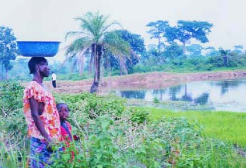
Photo 12: Rice, fish and vegetable production are often associated in inland valleys in West Africa (Côte d'Ivoire). (Photo: FAO/G. Juanich)
Photo 13: Rice management, including establishment of the crop with pre-germinated rice seeds, is often being done from the plane in large-scale irrigation schemes in Latin America. Aquaculture has the potential to augment low incomes derived from rice, but requires an integrated approach to pest management (Suriname). (Photo: FAO/M. Halwart)
Literature cited
Balzer, T., Balzer, P. & Pon, S. 2002. Traditional use and availability of aquatic biodiversity in rice-based ecosystems. I. Kampong Thom Province, Kingdom of Cambodia. Edited by M. Halwart & D. Bartley (FAO) and H. Guttman (Guest editor, MRC). CD ROM. FAO, Rome, Italy. Available at: //ftp.fao.org/fi/CDrom/AwarnessAgrBiodiv/Main.pdf
Choulamany, X., in prep. Traditional use and availability of aquatic biodiversity in rice-based ecosystems. IV. Northern Laos. Edited by M. Halwart & D. Bartley (FAO) and S. Funge-Smith (Guest Editor, FAO/RAP). CD ROM. FAO, Rome.
Demaine, H. & Halwart, M. 2001. An overview of rice-based small-scale aquaculture. In: IIRR, IDRC, FAO, NACA and ICLARM 2001. Utilizing different aquatic resources for livelihoods in Asia: a resource book, pp. 189-197. International Institute of Rural Reconstruction, International Development Research Centre, Food and Agriculture Organization of the United Nations, Network of Aquaculture Centers in Asia-Pacific, and International Center for Living Aquatic Resources Management.
FAO. 2002. Report of the 20th Session of the International Rice Commission held in Bangkok, Thailand from 23-26 July 2002. FAO, Rome. 46 pp.
FAO/MRC. 2003. New approaches for the improvement of inland capture fishery statistics in the Mekong Basin. Report of the Ad Hoc Expert Consultation held in Udon Thani, Thailand, 2-5 September 2002. FAO/RAPPublication 2003/01. FAO/RAP, Bangkok. 145 pp.
FAO/NACA. 2003. Traditional use and availability of aquatic biodiversity in rice-based ecosystems. Report of a Workshop held in Xishuangbanna, Yunnan, P.R. China, 21-23 October 2002. FAO, Rome. Available at ftp://ftp.fao.org/fi/document/xishuangbanna/xishuangbanna.pdf
Fernando, C.H. 1993. Rice field ecology and fish culture: An overview. Hydrobiologia, 259: 91-113.
Fernando, C.H. & Halwart, M. 2001. Fish farming in irrigation systems: Sri Lanka and global view. Sri Lanka J. Aquat. Sc., 6: 1-74.
Halwart, M. 1994. Fish as biocontrol agents in rice - The potential of common carp Cyprinus carpio and Nile tilapia Oreochromis niloticus. Margraf Verlag, Weikersheim, F.R. Germany, 169 pp.
Halwart, M. 1998. Trends in Rice-Fish Farming. FAO Aquaculture Newsletter, 18: 30-11.
Halwart, M. 1999. Fish in rice-based farming systems - Trends and prospects. In Dat van Tran, ed. International Rice Commission - Assessment and orientation towards the 21st century. Proceedings of the 19th Session of the International Rice Commission, pp. 130-141. Cairo, Egypt, 7-9 September 1998. 260 pp.
Halwart, M. 2001. Fish as biocontrol agents of vectors and pests of medical and agricultural importance. In: IIRR, IDRC, FAO, NACAand ICLARM 2001. Utilizing different aquatic resources for livelihoods in Asia: a resource book. pp. 70-75. International Institute of Rural Reconstruction, International Development Research Centre, Food and Agriculture Organization of the United Nations, Network of Aquaculture Centers in Asia-Pacific and International Center for Living Aquatic Resources Management.
Halwart, M. 2003. Recent initiatives on the availability and use of aquatic organisms in rice-based farming. In Proceedings of the 20th Session of the International Rice Commission.Bangkok, Thailand, 23-26 July 2002. pp. 195-206. FAO, Rome.
Luo, A. (in press) Traditional use and availability of aquatic biodiversity in rice-based ecosystems. II. Xishuangbanna, Yunnan, P.R. China. Edited by M. Halwart & D. Bartley (FAO) and J. Margraf (Guest editor, EC). CD ROM. FAO, Rome.
Meusch, E. (in prep.) Traditional use and availability of aquatic biodiversity in rice-based ecosystems. III. Northwestern Viet Nam. Edited by M. Halwart & D. Bartley (FAO). CD ROM. FAO, Rome.
Meusch, E. (in prep.) Participatory assessment of the role and nutritional value of aquatic resources in the livelihoods of rural people in Attapeu Province, Lao PDR. A contribution to the "Dialogue on Water, Food and the Environment"; IUCN - the World Conservation Union & Food and Agriculture Organization. Bangkok, Thailand.
Rola, A. & Pingali, P. 1993. Pesticides, rice productivity, and farmers'health - an economic assessment. Manila, Philippines, International Rice Research Institute and World Resources Institute. 100 pp.
Setboonsarng, S. 1994. Farmers'perception towards wild fish in ricefields: "Product, not predator" -an experience in rice-fish development in Northeast Thailand. In: C.R.dela Cruz, ed. Role of fish in enhancing ricefield ecology and in integrated pest management. ICLARM Conf. Proc. 43. International Center for Living Aquatic Resources Management, Manila, Philippines.
Smith, J.D. 2001 Biodiversity, the life of Cambodia - Cambodian Biodiversity Status Report 2001. Cambodia Biodiversity Enabling Activity. Phnom Penh, Cambodia.
J. Aguilar-Manjarrez. Fishery Resources Officer (Inland
Fisheries GIS)
Inland Water Resources and Aquaculture Service
(FIRI)
and
J.M. Kapetsky, Senior Fishery Resources Officer
(retired)
and consultant for the Inland Water Resources and Aquaculture
Service (FIRI)
Introduction
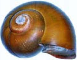
Regarding fished water bodies, a traditional view of inland fisheries is evocative of the exploitation of perennial waters such as lakes (Map 10), rivers (Map 11), streams and ponds; however, in practice important quantities of aquatic products are taken from a variety of other kinds of water bodies, both natural and artificial. Among other kinds of natural water bodies that are exploited are swamps, freshwater marshes, and seasonally inundated waters (Map 12) including floodplains and floodplain lakes, flooded forests, and ephemeral streams (Map 13). Additionally, channels among mangroves, salt marshes, coastal lagoons and estuaries are the province of inland fisheries, as well. Among the fished artificial water bodies are reservoirs, borrow pits, flooded quarries and surface mine pits, rice fields, village and household water supply ponds (Map 14), stock watering ponds, irrigation canals and ditches.
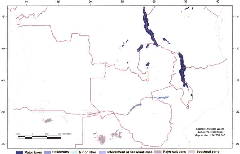
Map 10: Major lakes of central, eastern, and southern Africa.
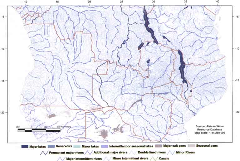
Map 11: Major lakes and river systems of central, eastern, and southern Africa.
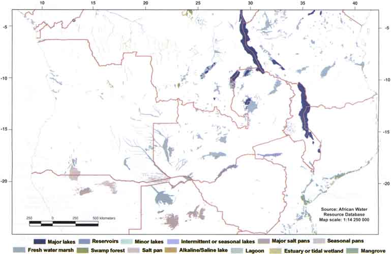
Map 12: Major lakes and dominate wetlands of central, eastern, and southern Africa.
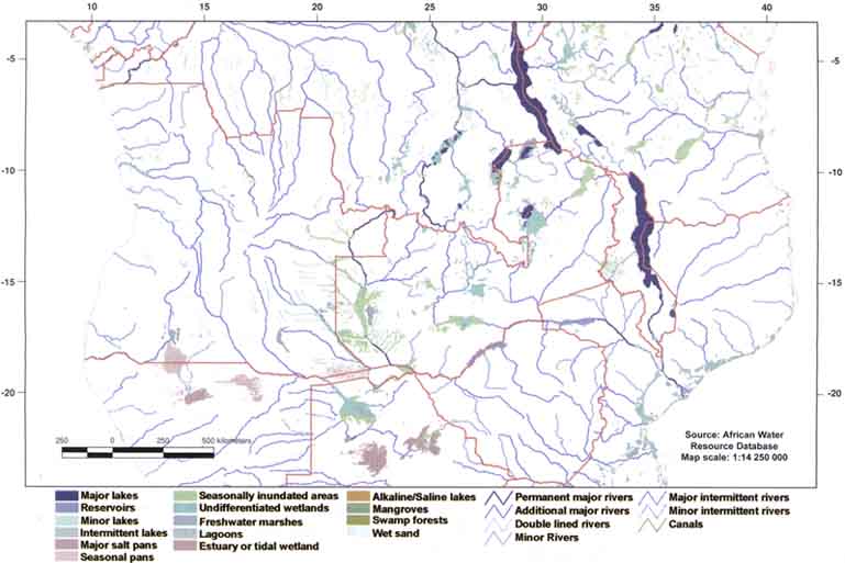
Map 13: Effective zones of inland fisheries habitat in central, eastern, and southern Africa.
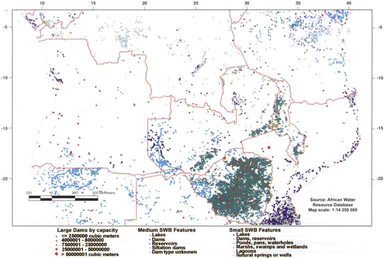
Map 14: Large, medium, and small surface waterbodies (swb) of central, eastern, and southern Africa.
It is these systems that are relatively small, or that vary in size and in time, or that are remote, or in countries that lack means, that present the difficulties for fully accounting for inland fish production, threats to the sustainability of inland fisheries, and fishery potential. Inventories of such water bodies are far from complete. For example, estimates of total global wetland areas differ widely: 5 203 000 km2, 1 271 000 km2 and 704 000 km2 according to various sources (Darras, Michou and Sarrat, 1998).
Issue
There is an urgent need for better data on inland fisheries that could be interpreted in both economic and ecological terms (FAO, 1999). Reporting should be by individual water bodies, or by clusters of them, and should enable considering the information in terms of river and lake basins. Although the cost of improving inland fishery data collection is high, failure to do so is also costly in terms of lessened or lost opportunities to increase food security and other social and economic benefits from inland fishery resources. Nevertheless, the fundamental problem for the sustainability of inland fisheries today remains the lack of quantitative information about them. Part of this problem stems from an even more basic lack of information on the locations and expanses of waters that support inland fisheries. Without such basic information, estimates of production and the socio-economic aspects of fishing will always be incomplete. By the same token, without such basic information, comprehensive estimates of inland fishery potential cannot be made and impacts of environmental changes on fishery resources cannot be gauged.
Actions - solutions
A framework in which to organize information about inland water systems exploited for fisheries is embodied in the Africa Water Resource Database (AWRD)[17]. The AWRD is a Geographic Information System (GIS) analytical framework supporting natural resource planning with a specific focus on inland fisheries and integrated water resource management (Dooley, Jenness and Aguilar-Manjarrez, 2003). The conceptualization for the AWRD is based on groundwork laid by a project entitled the "SADC Water Resource Database (WRD)" coordinated by the Aquatic Resource Management for Local Communities Development Programme (ALCOM) for the Southern African Development Community (SADC) region. The AWRD represents both the continuation and enhancement of the body of work resulting from ALCOM's earlier efforts (Johnson and Verheust, 1998; Verheust and Johnson, 1998a; Verheust and Johnson, 1998b). Development of the AWRD is a work in progress being carried out under the guidance of the Inland Water Resources and Aquaculture Service (FIRI) of the Food and Agriculture Organization of the United Nations (FAO).
The main objective of the AWRD effort is to provide water and natural resource managers with tools which foster the sustainable use of water resources as a means of promoting the responsible management of living aquatic resources and increasing food security.
In addition to the SADC-WRD data baseline, the core datasets which populate the AWRD have been expanded to cover continental Africa and the island states. Geographic data within the WRD were reformatted into ESRI's GIS Shapefile[18] format and the interface was reprogrammed to run from ESRI's ArcView GIS software. Currently, there are over seventy-five datasets populating the AWRD data archive. The core data layers include: various depictions of surface water bodies; multiple watershed models; aquatic species; rivers; political boundaries; population density; soils; satellite imagery; and many other physiographic and climatological data types. In general, the source scale of these data support analyses from 1:1 000 000 to 1:5 000 000 for vector data, and a nominal resolution of 1 to 5 kilometres for raster data.
To display and analyse the datasets compiled, the AWRD contains an assortment of new custom-designed applications and tools. Currently, there are six analytical modules within the AWRD interface:
1. a surface waterbodies statistics module;
2. a watersheds statistics module and visualization tool;
3. an aquatic species module;
4. a data classification and statistical analysis module;
5. a metadata module; and
6. various customization and user enhancement tools.
Most tools come with simple and advanced options and are fully described in help menus and a set of six applications illustrating various decision support scenarios using the AWRD are available as users aids and training examples.
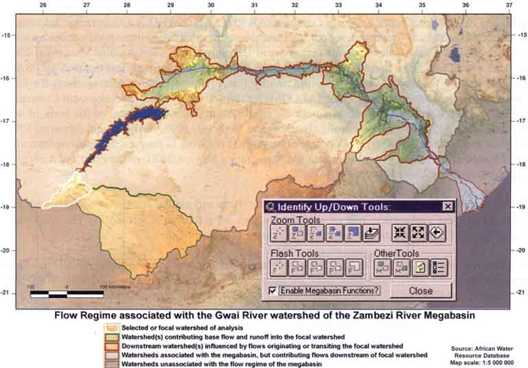
Map 15: River basin analysis and visualisation using the watershed module of the African water resource database.
Through the AWRD interface users have the ability to access tabular and spatial data viewers, while also gaining the ability to visualize and analyse the complex hydrological and ecological relationships within specific river reaches, larger-scale river basins, or entire megabasins. Thus, the AWRD can help improve or ease fishery or integrated management decisions (Map 15).
Some examples of the benefits that the use of the AWRD could provide are: improved inland fisheries and aquaculture management; more comprehensive inland fisheries and aquaculture statistics organized ecologically by water body, river and lake basins; improved information for inland fisheries and aquaculture planning leading to a more sustainable use of natural resources; and support of decision-making aimed at: assessing the state of the inland fishery environment (e.g. climatic changes, human-induced changes, watershed vulnerability,and transboundary issues, for example to help assess the risks and benefits from the use of alien species (i.e. introduced or exotic species) in fisheries and aquaculture); reversing degradation of the environment and reducing loss of habitats; multi-purpose conservation, rehabilitation and restoration of aquatic systems and habitats, opportunities and constraints to inland fishery enhancements; conflict resolution of allocation of resources; and increasing community-level responsibility for management of watersheds.
Currently, efforts are being made to assess the use some of the core datasets of the AWRD (e.g. watersheds) to produce a consistent standardized hydrological database that can be distributed under copyright in the public domain. There are some opportunities for synergies between the standards that will be proposed through the AWRD effort within FAO and also with several task forces set-up by the United Nations Geographical Information Working Group (UNGIWG; http://www.un.org/Depts/Cartographic/english/htmain.htm), as it is one of the biggest users of spatial data within the UN system. The initial focal scale for these hydrological datasets will be between 1:1 million and 1:5 millions.
The AWRD builds on an established body of work, and strategies are currently being developed to promote research, education, training and decision-making, using the AWRD. Potential enhancements to the AWRD include: a river systems network module; a water demand and irrigation analyser; a runoff and flood predictor; and a basemap viewer and output module. Other possible developments include: an on-line collaboration and data maintenance system; and the eventual global expansion of relevant data layers.
From a fisheries viewpoint it is important to note that the various water body maps are linked to data to characterize them in terms of their physical and administrative characteristics as well as the landscapes around them (Map 16). Historical production and limnological data, available for most of the larger water bodies, and many smaller ones, can also be linked for analysis. With a flood predictor planned as an enhancement, it may be possible to dynamically predict floodplain fishery production one to two years ahead of the current production year.
The AWRD provides a solid framework for inland fisheries and environmental information in Africa. One of the next steps should be to find ways to assist countries to facilitate the organization of national level fisheries and environmental data collection, storage, and the manipulation and analysis of data within a version of AWRD specifically modified for that purpose for countries in Africa. Another step would be to assist countries in Latin America and Asia to investigate the possibility of creating AWRD-like frameworks for their regions.
The beneficiaries of the AWRD will mainly consist of people working with global and regional analysis on water and inland aquatic resource management and planning in national and international institutions, including researchers and project managers. The first version of the AWRD will be made available in early 2004 as an FAO technical publication and a set of CD-ROM data disks.
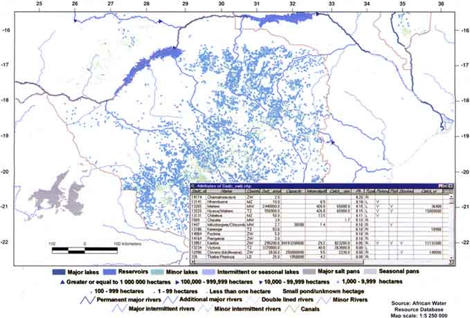
Map 16: Small water bodies in Zimbabwe including tabular attribute information.
Literature cited
Darras, S., Michou, M., & Sarrat, C. 1998. The IGBP-DIS wetland data initiative and the RAMSAR convention. Afirst step towards identifying a global delineation of wetlands. http://ceos.cnes.fr:8100/cdrom-00b2/ceos1/casestud/igbp/igbp.htm.
Dooley, J., Jenness, J. & Aguilar-Manjarrez, J. 2003. The African Water Resource Database. In Proceedings of the 21st International Cartographic Conference and 12th General Assembly of the International Cartographic Association, pp. 2154-2165. Durban, South Africa. 10-16 August 2003. http://www.icc2003.gov.za/.
FAO. 1999. Review of the state of world fishery resources: inland fisheries. FAO Fisheries Circular No. 942. Rome. 53 pp.
Johnson, G. & Verheust, L. 1998. Naming, typing, correcting and linking of the DCW inland water coverage for Africa. Harare, Zimbabwe, ALCOM/FAO. 27 pp.
Verheust, L. & Johnson, G. 1998a. The SADC water resource database: contents, data structure and user interface. Harare, Zimbabwe, ALCOM/FAO. 39 pp. http://www.fao.org/fi/alcom/wrd.htm.
Verheust, L. & Johnson, G. 1998b. The watershed database for sub-equatorial Africa, structure and user interface. Harare, Zimbabwe, ALCOM/FAO. 21 pp. http://www.fao.org/fi/alcom/wrd.htm.
|
Glossary Sources:
GIS: Geographic Information System. An organized collection of computer hardware, software, geographic data, and personnel designed to efficiently capture, store, update, analyse, and display all forms of geographically referenced information. Raster: Amethod for the storage, processing and display of spatial data. Each given area is divided into rows and columns, which form a regular grid structure. Vector: One method of data type, used to store spatial data. Vector data is comprised of lines or arcs, defined by beginning and end points, which meet at nodes. |
J.M. Kapetsky, Senior Fishery Resources Officer
(retired),
and consultant for the Inland Water Resources and Aquaculture
Service (FIRI)
Inland fisheries and human development
The Human Development Index[19] (HDI) measures a country's achievements in three aspects of human development: longevity, knowledge, and a decent standard of living. Longevity is measured by life expectancy at birth; knowledge is measured by a combination of the adult literacy rate and the combined gross primary, secondary, and tertiary enrolment ratio; and standard of living is measured by GDPper capita (PPPUS$).
The HDI is divided into three ranges: high (>0.80), medium (>0.5), and low (<0.5)[20]. The HDI of the top 20 countries in inland capture fisheries production in 2002 ranges from 0.80 down to 0.39. Thirteen countries fall into the medium range and the remainder into the low range (Figure 2.6.1).
Figure 2.6.1: Top 20 countries in inland capture fisheries production and the HDI
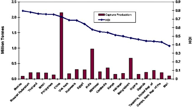
Of the 150 inland fisheries countries, there were 139 for which the HD Index was available. World wide, most of the inland capture fisheries countries for which there were HDI data fall into the medium category (Map 17). Of the 33 inland capture fisheries countries with low human development indices, inland capture fisheries are the sole source of inland fish in 16, and inland fisheries account for at least 81 percent of inland fish production in an additional 14 countries. Thus, fishing is an important activity in countries with low HDI. Fishery management and development and assistance activities aimed at improving the HDI of these countries must take into account this dependence.
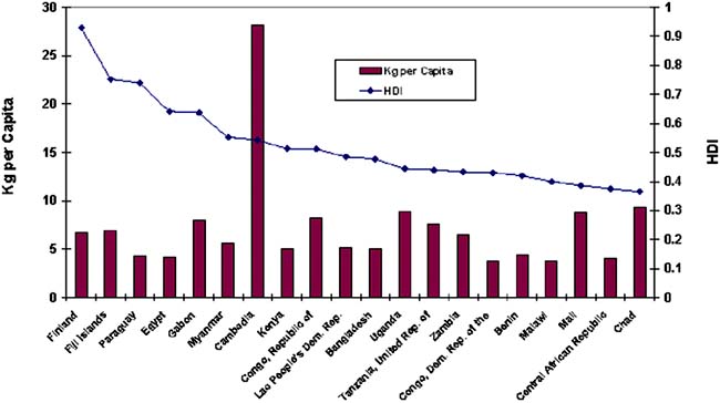
Viewed in terms of per capita inland production, the surrogate for the inland capture fisheries food supply, one of the top 20 countries is in the high HDI category, eight are in the medium HDI category, and the remainder, 11 are in the low HDI category (Figure 2.6.2).
Map 17: The Human Development Index and inland capture fisheries countries

Figure 2.6.2: Top 20 countries in inland capture fisheries production per capita and the HDI
The Environmental Sustainability Index
The Environmental Sustainability Index[21] (ESI) is a measure of overall progress towards environmental sustainability that has been developed for 142 countries of which 133 inland fisheries countries are included here. The higher a country's ESI score, the better positioned it is to maintain favorable environmental conditions into the future. However, no country is on a truly sustainable path. Every country has some issues on which its performance is below average. Thus, on a scale of 0 to 100, the actual scores range from 23.9 to 73.9 with a mean of 49.4.The ESI scores are based upon a set of 20 "indicators", each of which combines two to eight variables for a total of 68 underlying variables. The ESI tracks relative success of each country in five core components:
Environmental Systems
Reducing Stresses
Reducing Human Vulnerability
Social and Institutional Capacity
Global Stewardship
The ESI permits cross-national comparisons of environmental progress in a systematic and quantitative fashion. It represents a first step towards a more analytically driven approach to environmental decision making.
Inland capture fisheries Production and Production per Capita Relative to the Environmental Sustainability Index
The mean ESI score is 50 and the median ESI score 49.5 (32.3-73.9 range) for the 133 inland fisheries countries for which the index is available. In order to provide meaning to a continuous string of values, the ESI scores were cast into ranges of 10 units each, and descriptive categories were assigned to each range. The ranges and categories are evident in the map entitled Inland Capture Fisheries Countries and the Environmental Sustainability Index.
The top 20 countries in inland capture fisheries production have ESI's that range from 36.7 to 59.6 (Figure 2.6.3). These values correspond to categories that extend from moderately low (8), to moderate (11), and to moderately high (1)[22].
The top 20 countries in per capita inland capture fisheries production have ESI's that range from 43.3 to 73.9 (Figure 2.6.4). These values correspond to categories that extend from moderately low (1) to moderate (15), to moderately high (2), to high (1). There is one country lacking an ESI index.
Looking world wide, 94 of the inland capture fisheries countries have ESI's that range from moderate to high, while there are only 39 that range from moderately low to low (Map 18). This is an encouraging outcome overall in so far as the ESI is indicative of the environmental sustainability of inland fisheries.
Of the 59 countries that provide at least 81 percent of inland fish production through inland capture and for which there also is an ESI, two are in the high ESI category, nine are in the moderately high category, 23 are in the moderate category, 22 are in the moderately low category, and three are in the low category. Thus, the view is relatively positive with 34 (59 percent) of the countries that are highly dependent on inland fish production for their fish supply having moderate, or better ESI. Also encouraging is that among the 10 countries that provide from 61 to 80 percent of inland fish production from inland waters, the ES index is high for two, moderately high for two, and moderate for four, with two lacking an ESI. Thus, in this category, too, the picture is relatively positive.
Figure 2.6.3: Top 20 countries in inland capture fisheries and the ESI

Figure 2.6.4: Top 20 countries in inland capture fisheries per capita and the ESI
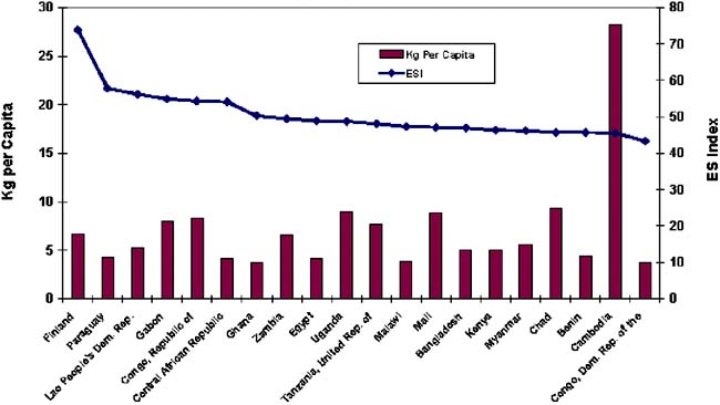
Map 18: Inland capture fisheries countries and the Environmental Sustainability Index
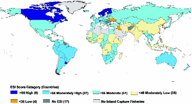
Of most potential concern are the inland fisheries countries for which the ESI ranges from moderately low to low and for which the 15-year trend in production is slowly or moderately decreasing (Figure 2.6.5). Fortunately, only ten countries among 133 fall into this category.
Figure 2.6.5: Trends in production and environmental sustainability indices for 133 inland fisheries countries
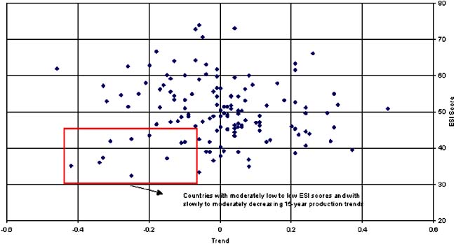
TR/D/J0703E/1/11.03/1400
|
[12] This paper is based on:
FAO/MRC. 2003. New Approaches for the Improvement of Inland Capture Fishery
Statistics in the Mekong Basin. Report of the FAO, MRC, Government of Thailand,
Government of the Netherlands Ad-hoc Expert Consultation, Udon Thani, Thailand,
2-5 September 2002. Inland fisheries in many parts of the world face similar
problems of poor information. Therefore these general results may be applicable
to areas outside of the Mekong/Lancang Basin. [13] See Box: INLAND FISHERY STATISTICS in Review of the state of world fishery resources: inland fisheries. Fisheries Circular 942. 1999, Rome, Italy. [14] Kapetsky, J.M. 2002. An assessment of the use of GIS and remote sensing in aquaculture and inland fisheries 1985 to 2002. A Report Produced for the FAO Inland Water Resources and Aquaculture Service while under contract from 15 May to 30 September, 2002. 32 pp. [15] The United Nations General Assembly (UNGA) declared the year 2004 the International Year of Rice (IYR) and invited the Food and Agriculture Organization of the United Nations to act as the lead agency for the implementation of the IYR, in collaboration with partners from national, regional, and international agencies, non-governmental organizations, and the private sector. The FAO Fisheries Department with the assistance of Fisheries Officers from the Regional and Sub-Regional Offices contributes to the IYR through various awareness-raising activities related to the importance of aquatic biodiversity in rice-based ecosystems. Information will be available and regularly updated at http://www.rice2004.com. [16] Aclear distinction between the capture and culture systems is not always possible. For example, an intermediate system exists in Thailand where the management system relies on stocked fish as prey to the wild species. These losses are accepted due to the high market value of the wild fish at local markets (Setboonsarng, 1994). [17] AWRD is a part of the Regular Programme of the FAO Inland Water Resources and Aquaculture Service (FIRI) for the Global Monitoring and Strategic Analysis of Inland Fisheries and Aquaculture. 001 - Development of architecture for global information systems and database on inland fisheries and aquaculture. [18] The Environmental Systems Research Institute (ESRI) "Shapefile" format is one of the most popular and widely available spatial data format used in GIS applications. [19] Human Development Reports, Frequently Asked Questions on the Human Development Indices at http://hdr.undp.org/statistics/faq.cfm#1. [20] The authors of the Human Development Indicators 2002 define the range values and categories. Excel files are available for download at http://hdr.undp.org/reports/global/2002/en/indicator/indicator.cfm?File=index.html. [21] Environmental Sustainability Index. An Initiative of the Global Leaders for Tomorrow Environment Task Force, World Economic Forum at http://ciesin.columbia.edu/indicators/ESI/ [22] For the purposes of this report ESI values were cast into ranges of 10 unit ranges and categories were assigned to each range. The ranges and categories are evident in the map entitled Inland Capture Fisheries Countries and the Environmental Sustainability Index. |
![]()
![]()