![]()
![]()
![]()
These notes are offered for engineers and aquaculturists whose task is to select sites, design or supervise construction of fish ponds, whether for rearing and growing-out, for holding broodstock, or for rearing fry or fingerlings. Such ponds may be part of a largescale commercial enterprise, or of a rural fish farm operated by a smallholder, or they may be used for training and demonstration or for research. For any of these kinds of enterprise to be successful, it is necessary, among other things, that the selection of the site and the design and construction of the pond (or ponds) be based on a thorough knowledge and wide experience of fish pond development and management. It is necessary, furthermore, to take into account not only the environmental conditions and the technical requirements, which depend on the species of fish and various operational considerations, but also the relevant socio-economic data.
1. PROCEDURES FOR SITE SELECTION
1.1 Preliminary surveys
1.1.1 Purpose of pond
Before a site be selected as suitable for construction of a fish pond, the following should be ascertained:
species to be cultivated
purpose:
2.1 hatchery
2.2 production pond
2.3 integrated pond
operational method
planned production
estimated size required.
1.1.2 Collection of data
The following information about the site should be gathered to facilitate the preliminary investigations and calculations (discussed later):
1.1.2.1 Documentary:
a contoured map of a scale about 1:50 000. This will help to determine the water catchment area and serve as a source of information on road connections, etc.;
a map showing boundaries of properties with different ownership, according to the official register of owners;
a soil, or geological, map;
a water resources development map. This will help by indicating possibilities of water supply and drainage, as well as by showing yield capacities of any aquifers;
a climatological map showing the meteorological stations nearest to the site and the monthly mean values of temperature and rainfall.
1.1.2.2 Meteorological data
The following data are needed for calculation of water requirements:
| mean | monthly | temperature |
| " | " | rainfall |
| " | " | evaporation |
| " | " | humidity |
| " | " | sunshine |
| " | " | wind speed and direction |
Information on the pattern of precipitation (maximum in any 24 hours) and incidence of high winds, heavy storms or typhoons, should be collected. The incidence and amount of damage caused by storms or earthquakes in the district should also be noted.
1.1.2.3 Hydrological data
The most important hydrological data needed for site selection can be gathered from such sources as Irrigation Departments and Departments of Meteorology. The data needs are as follows:
For fresh water ponds:
data for discharge, yield, floods and water elevations of existing water sources (creek, lagoon, river, irrigation canal, spring, reservoir);
restrictions for water supply to the pond (for example periods of the maintenance works in the irrigation canal);
possibility of drainage.
For brackish water ponds:
tide table or tidal observations for the Standard Port nearest to the site.
1.1.2.4 Infrastructure and manpower
development plan for the district
availability of land and likely price
proximity to all-weather road connections
availability of electricity and if telephone or radio connections exist
availability of equipment, services and supplies needed for managing the ponds
location of markets for the aquaculture produce
availability of construction materials, stocking materials (brood stock or spawners, fry or fingerlings, etc.), supplementary feeds, fertilizers, etc.
availability of suitable transport facilities for marketing product, ice, etc.
availability of staff with adequate experience of pond management
availability of skilled and semi-skilled labourers adjacent to the site
reasonable amenities for senior staff, for example, schools, shopping facilities.
1.2 Reconnaissance
In order to select a suitable location for the pond the following factors have to be examined on the site:
1.2.1 Land
It should be confirmed that the proposed land area is suitable, given the need for supporting infrastructure and availability of manpower (see 1.1.2.4). The conformation of the land should preferably be flat with slopes not steeper than 2 percent. It should be free from frequent deep flooding: the 10 year flood or the highest astronomical tide (HAT) should be no higher than about 2.0 m above the average original ground level. Observation of the marks left by flood waters on bridges or other structures at the site, or questioning of local people, may give information about the expected heights of floods.
It is important to know the development plan for the district because it would be unwise to construct a fish pond in the vicinity of a site where future industrial activity may cause air or water pollution. Thus, areas close to textile mills or harbours are not suitable for aquaculture development.
Similarly, if the site is adjacent to a heavily populated area, the risk of pollution should particularly be borne in mind. Some industrial and agricultural wastes are useful in pond culture, but the fish farmer should be able to control their application.
Underground utilities (oil pipelines, etc.) may render otherwise good sites unsuitable for pond construction; so may high power poles, radio masts and the like.
1.2.2 Vegetation
The type and density of vegetation depend partly on the land elevation. Vegetation is also an indicator of soil types and of the elevation of the water table.
The type and density of vegetation, its size and the root systems of trees largely determine the method of clearing the site and, therefore, the construction time and cost.
Paddy fields, grass land, open woodland or land covered with low shrubs and bushes allow cheaper pond construction than land with very thick jungle or swampy areas with high trees.
However, in the typhoon belt or in areas where strong winds are frequent it is very important to have a wide and high windbreak of thick vegetation in the direction of the wind. Similarly protection against storm waves is desirable at sites near the shoreline. Branches of mangrove can be used as wave breakers inside the pond.
1.2.3 Soil
Field investigations to determine surface and subsurface conditions at the site should be made as early as possible. Often money can be saved if soil explorations are made before the site is purchased. They may reveal soil conditions undesirable for constructing ponds, in which case another site may be selected. Investigations should be carried out in order to ascertain the suitability of soil both for pond construction and as regards fertility.
Techniques used for site investigations vary from relatively simple visual inspection to detailed subsurface exploration and laboratory tests. Which techniques should be used and to what extent depends upon the findings of preliminary explorations. Visual inspection is an essential preliminary step. In order to provide data on subsurface soils a test pit measuring 0.80 × 1.50 m with a depth of 1.50 to 2.0 m, depending on the land form and the elevation of the water table, should be dug in each hectare of the site. Digging of a test pit permits visual examination of soil and also makes it possible to obtain undisturbed samples of soils for laboratory test.
Soils have characteristics that can easily be determined by sight and feel. A useful system of classification for field visual examination might be as follows:
Gravel - Coarse particles larger than 2 mm in diameter.
Sand - Smaller than gravel, but still large enough for the individual grains to be felt when rubbed between fingers.
Sandy loam - Essentially a granular soil with sufficient silt and clay to make it somewhat coherent. Sand characteristics predominate. It forms a ball which bears careful handling without breaking, but when allowed to get air-dry the ball falls apart when lightly touched. A ball cannot be extruded into ribbons between the fingers when grasped tightly.
Loam - A uniform mixture of sand, silt and clay. Grading of sand fraction is quite uniform from coarse to fine. It is soft and has a somewhat gritty feel, yet is fairly smooth and slightly plastic. When squeezed in the hand and pressure is released, it will form a ball which can be handled freely without breaking. It cannot be extruded into ribbons between the fingers when moist.
Silt - Particles so fine they cannot be distinguished by sight, except under a microscope. Because of its smooth texture, silt is often mistaken for clay but it may be readily distinguished from clay without laboratory testing. If shaken in the palm of the hand, a pat of saturated silt expels enough water to make its surface appear glossy. If the pat is bent between the fingers, its surface again becomes dull. After the pat has dried, it is brittle, and dust can be detached by rubbing it with the finger.
Silty loam - This contains a moderate amount of finer grades of sand and only a small amount of clay, but over half of its particles are silt. When it is dry, it may appear quite cloddy; it can be readily broken and pulverized to powder. When a ball is formed and air-dried, it can be freely handled. After it has been wetted it will be smooth and slightly plastic.
Clay - Particles are finer than silt. It is plastic with a moderate to wide range of water content.
| Very soft | - | Exudes between the fingers when squeezed in the fist |
| Soft | - | Easily moulded in the fingers |
| Firm | - | Can be moulded in the fingers, but takes strong pressure |
| Stiff | - | Cannot be moulded in the fingers |
| Very stiff | - | Rigid and tough |
Organic soil - The outstanding characteristic is high organic matter content. Shells and visible fragments of partly decayed vegetable matter may be present. It is usually dark brown or black in colour and it is likely to contain a considerable quantity of H2S, CO2, and various other gaseous products of the decay of organic matter which give it a characteristic odour. The permeability of organic soil is very low and its compressibility very high. Peat is a somewhat fibrous aggregate of macroscopic and microscopic fragments of decayed vegetable matter. Its colour ranges between light brown and black. It contains much humid acid.
A sandy clay to clayey loam is the best type of soil. It permits both pond construction and good growth of algae. The quality of the soil in a brackish water pond is of even greater significance for productivity than in a fresh water pond. Areas with a layer of organic soil over 0.60 m in thickness are unsuitable for any kind of fish ponds; it would be difficult to maintain water levels in a pond because of high seepage; also it would be necessary to transport suitable soils for bund construction to the site, and this will be costly.
Big surface stones or rock outcrops may make an area unsuitable for anything except concrete lined ponds or concrete raceways for trout.
1.2.4 Water
An assured water supply of adequate quality is the most important feature of a site suitable for a fish pond. Water requirements should be calculated on an annual basis; they include not only the water for filling (or refilling) the pond but also that needed to replace losses by evaporation and by seepage through the bottom, as well as by leakage from the feeder canal and through the bunds and sluices. Seepage and leakage depend on the kind of soil in which the pond is situated and the quality of bund construction.
For a pond built in suitable soil, the minimum supply of water should be 5 1/s/ha of pond throughout the year.
The source of water may be spring, rainfall runoff, creek, river, irrigation canal, reservoir, as well as dug or deep wells, and for sea water a lagoon or other sheltered inlet, or the open sea, using tidal rise and fall, or pumps. Water can be supplied via feeder canal, storage tank or pipeline; by gravity or by direct pumping to the pond. The most economical method is by gravity.
If rainfall runoff has to be used, a ratio of 10 ha of catchment area to one ha of pond is required if the catchment area is pasture; a slightly higher ratio is needed for woodland and less for land under cultivation.
An adequate tidal range is one of the main factors to be considered in choosing sites for coastal or estaurine ponds. A tidal range of 1.5 m is necessary for brackish water ponds in order to allow drainage by gravity and replenishment at high tide; otherwise the pond must be situated so that drainage is by gravity and replenishment by pump. The relationship of the tidal characteristic between the nearest standard port and the site should be determined by recording tidal ranges through a gauge placed at the site. The mean low tide level at the site may then be determined. The bottom elevations of any pond must be above mean low tide level so that it can be drained by gravity. Usually, the water in the pond will be maintained at depths of 0.50 to 1.0 m depending upon the species being cultured.
For draining of a fresh water pond by gravity its bottom should be at a level higher than that which the water table reaches during a normal year.
1.2.4.1 Water quality
Quality of water is very important. It should be investigated by taking water samples from the proposed source for laboratory analyses of physical, chemical, biological and microbiological properties, including feedom from health hazards. Water test procedures should be in accordance with the Standard Classification in Sri Lanka on water quality. Emphasis should be placed on the following parameters:
physical properties - temperature, colour, odour, turbidity, transparency, suspended solids.
chemical properties - pH, dissolved oxygen, biochemical oxygen demand, free carbon dioxide, alkalinity, salinity, dissolved solids, ammonia; all as regards both useful and toxic qualities; also whether pollutants are present of agricultural or industrial origin and to what extent;
biological properties - quality and density of plankton;
micro-biological properties - species and quantity of parasites.
2. PROCEDURES FOR DESIGNING POND
2.1 Detailed investigations
2.1.1 A topographic survey should be carried out based on a datum marked with a temporary bench mark (TBM). This should be used to prepare an accurate plan of the site on a scale of 1:1 000 to 1:2 000, depending on the size of proposed ponds. The plan should show contours at a vertical interval of 0.2 to 0.5 m, as well as roads, creeks, rivers, canals, power lines, boundaries of properties, any existing ponds and buildings, etc. The location of the soil samples, TBM, etc., should be clearly marked.
2.1.2 Soil survey
Depending on the results of the preliminary exploration and the size of the area, borings should be made to obtain more detailed information on the characteristics of the subsoil. The depth of each borehole should be 1.0 m below the deepest intended excavation in the pond area. The number of borings required depends upon what types of soils are encountered in the boreholes. It is suggested that as a minimum in uniform soil conditions, 1 to 2 sample stations be used for each hectare of the site. More borings will be required in variable soil conditions. A number of disturbed and undisturbed samples should be taken from the borings for laboratory tests. These tests should establish wet and dry unit weights, moisture content, void ratio, liquid and plastic limits, plasticity index, grain-size curves, coefficient of permeability. The results of the laboratory tests should be recorded for each sampling station, in a soil report. The report should specify: results of laboratory tests, soil properties, date of borings, surface elevation, the water table, and the location of the station.
In general, a site will be suitable for fish ponds if soils at the level of the proposed pond bottoms have a grain-size such that it can be plotted to the left side of the grain size curve A in Fig. 2, together with a coefficient of permeability less than k = 5 × 10⁻⁶ m/sec. Bunds without any impervious clay core may be built from soils having grain size curves plotted between the grain size curves A and B in Fig. 2 or their coefficient of permeability being between k = 5 × 10⁻⁶ to 1 × 10⁻⁴ m/sec.
Impervious clay core should be:
| liquid limit | < | 80 percent |
| plastic limit | < | 20 percent |
| plasticity index | > | 30 percent |
2.2 Design of fresh water ponds
The following basic technical procedures and criteria should be adopted for the design of fresh water ponds:
2.2.1 Water requirements for ponds
The yearly water requirement of a pond will depend on the soil conditions, environmental factors, cultured species and the chosen technology of fish culture. The necessary amount of water for a pond in an average year can be calculated using the equation:
WR = Vf + Vrf + Le + Ls + Lc - Vra (units in m3)

| where | WR | = | water requirement for an average year (m3) |
| Vf | = | A × H = the pond volume to be filled with water (m3) | |
| A | = | water surface area of pond (m2) | |
| H | = | average water depth of pond (m) | |
| Vrf | = | No. Vf = the pond volume to be refilled (m3) | |
| No. | = | number of refillings | |
| Le | = | A × E = water loss from evaporation (m3) | |
| E | = | mean annual evaporation (m) | |
| Ls | = | A × 356 × S = seepage loss (m3) | |
| S | = | seepage coefficient (m/day) | |
| Lc | = | Ac × 1.2E = transmission loss in earthen canal (m3) | |
| Ac | = | water surface area of feeder canal (m2) | |
| Vra | = | A × RA × water inflow from rainfall (m3) | |
| RA | = | mean annual rainfall (m) |
If rainfall runoff is used for water supply of pond, the amount of water from its catchment area in a year can be calculated using the following equation:
Wca = Aca × RA × Rc (m3)
| where | Aca | = | catchment area (m2) |
| RA | = | mean annual rainfall (m) | |
| Rc | = | runoff coefficient (%) |
2.2.2 Design of water supply and drainage for pond
For designing inlets of ponds the required filling times of different types of ponds should be as follows:
| Type of ponds | Filling time in days |
| Spawning | 0.1 – 0.3 |
| Nursery | 0.2 – 0.5 |
| Rearing and production | 1 – 10 |
| Holding | 0.5 – 2 |
For calculation of the discharge of the feeder canal including intake structure or pumping station, etc. the filling time of all the ponds should be considered as 6 to 30 days for 5 to 25 hectares of total water surface area of ponds.
The drainage time for different types of ponds should be as follows:
| Type of ponds | Drainage time in days |
| Spawning | 0.2 – 0.4 |
| Nursery | 0.2 – 0.5 |
| Rearing and production | 2 – 8 |
| Holding | 0.5 – 1.0 |
The total drainage time of all the ponds should be 5 to 25 days for 5 to 25 ha ponds.
The outlet structures and the drainage canals should be calculated with the above drainage times.
For designing feeder and drainage canals, the following allowable velocities and side slopes in various soils or covering should be assumed:
| Types of soils or covering | Velocity m/sec | Side slopes |
| Sandy loam | 0.2 – 0.25 | 1:3 |
| Sand | 0.4 – 0.6 | 1:2.5 |
| Silt | 0.5 – 0.6 | 1:2 |
| Clay | 0.5 – 1.5 | 1:1.5 |
| Gravel | 1.0 – 2.4 | 1:1.5 |
| Brick/stone | 1.4 – 5.8 | 1:1 |
| Concrete | 3.0 |
2.2.3 Design of bund
Measurements and slopes of bunds should be determined according to the designed depth of water in the pond, the size of the pond, soil conditions and the requirements of transport and transit on the bund. The following figures represent good practice:
| Water depth in the pond (m) | Top width of bund (m) | Freeboard1 (m) |
| 0.50 | 0.50 | 0.40 |
| 0.50 – 0.70 | 0.50 – 1.00 | 0.40 – 0.50 |
| 0.70 – 1.20 | 1.50 | 0.50 |
| 1.20 – 1.80 | 2.0 – 2.50 | 0.50 |
Top width for a road carrying vehicles should be a minimum of 3.0 m. If there is a feeder canal on the top of the bund, its top width should be wide enough for both the feeder canal and a road or a passage way. The latter is needed for pond operations and maintenance of inlets and feeder canal.
Side slopes as a function of type of soil and pond lining
The following slopes are suggested for sides of bunds in various soils:
| Type of soils | Inside slope | Outside slope |
| Sandy loam | 1:2 – 1:3 | 1:1.5 – 1:2 |
| Sandy clay | 1:1.5 | 1:1.5 |
| Firm clay | 1:1 | 1:1 |
| Inside brick lining | 1:1 – 1:1.5 | 1:1.5 – 1:2 |
| Inside concrete lining | 0.75:1 – 1:1 | 1:1.5 – 1:2 |
The exposed parts of the bund (outside slope, crown, inside slope above the water level) should be protected by grass against erosion. In ponds with more than about 0.1 ha of water surface, wave protection made of branches, brick lining, riprap, etc., should be placed at the designed water level.
A berm with a width of two to four metres should be left between the bund toe and the borrow pit inside the pond as well as outside, between the bund toe and the drainage canal.
2.2.4 Design of bottom of pond
In order to drain the pond easily and completely, the bottom of the pond should be sloped towards the outlet, or ditches with widths of 0.50–1.0 m should be excavated in the bottom of the pond and connected to the outlet. In order to drain the pond perfectly, the bottom of the drainage canal should be 0.5 m below the level of the pond bottom.
2.2.5 Design of inlet and outlet structures
A pond for intensive fish culture should have separate inlet and outlet structures for water supply and drainage. The inlet may be anything from a simple pipe to a concrete sluice. It is very important that the inlet be screened to prevent foreign bodies and predatory fish from entering the pond. The floor level of the inlet should be higher by a minimum 0.10 m than the water level in the pond to avoid escape of farmed stock. Protection should be provided against erosion under and around the inlet.
The inlet is better located in the centre of the short side of the pond, in order to ensure good water circulation.
The outlet should be, generally, on the opposite side to the inlet. The best type of outlet for controlling water level in the pond and draining the pond is the monk. The monk consists of a vertical tower with three pairs of grooves for housing screens and stoplogs and a horizontal conduit passing across the bund at the level of the bottom on the pond. It is advisable to provide a harvesting box at the outside end of the conduit for harvesting the pond without netting. This harvesting box may also be used for breeding hapas or for holding fish for marketing.
The size of inlet and outlet should be calculated on the basis of the time needed for filling or draining the pond, respectively.
For designing outlets, the following average discharge of pipes in different diameter should be assumed for ponds of designs conforming to the above:
| Diameter of pipe (m) | Discharge of pipe (m3/s) |
| 0.30 | 0.08 |
| 0.40 | 0.13 |
| 0.50 | 0.20 |
| 0.60 | 0.30 |
| 0.80 | 0.50 |
| 1.00 | 0.80 |
2.3 Design of brackish water pond
In planning the layout of ponds and other facilities, maximum advantage should be taken of topographical features of the site, not only to economize on the cost of earthworks in construction, but also to preserve the soil fertility and provide a better environment for immediate operation of the ponds.
2.3.1 Layout of ponds
The layout of ponds depends on the site and shape of the selected area, the culture systems, the purposes of production, as well as the locations of creeks, rivers or lagoons. These will also determine the number and sizes of nursery, transition and rearing ponds, including their water supply and drainage structures (gates). Therefore, a layout plan of a brackish water fish farm will be found to include not only ponds but also water control structures, including bunds, canals and gates, as well as additional facilities such as roads, power lines, buildings, pumping house, etc.
2.3.2 Design of water supply and drainage system of ponds
The tidal range and ground elevation at the selected site will determine the best water supply and drainage system. There are two water supply and drainage systems used for brackish water ponds: use of a common canal and use of separate canals for drainage and supply of water.
Although generally the construction cost is lowest for a common canal used for both inflow and outflow, there are many disadvantages including:
Separate canals for water supply and drainage of the ponds have the following advantages:
For designing water supply and drainage systems of ponds, including their main gates, secondary gates or division boxes and tertiary gates, the following procedures are recommended:
Determine the relation between tidal levels and ground elevation at the site. For this purpose, the relationship should be determined between the nearest standard port and a gauge placed at the site. According to the observations of the site gauge, it is necessary to calculate data on:
| • | highest astronomical tide | (HAT) |
| • | mean high high water | (MHHW) |
| • | mean low high water | (MLHW) |
| • | mean high low water | (MHLW) |
| • | mean low low water | (MLLW) |
Determine relation between diurnal inequality of the tide level and ground elevation at the site (tide curve).
Determine the water depth required in the ponds. The minimum acceptable water depth for rearing shrimp or milkfish is 0.40 m in the platform, 0.70 m in the peripheral ditch and 1.0 m in the drainage canal. For draining the ponds completely it is necessary for the bottom of the drainage canal to be above the datum (generally the MHLW). For supplying water to the ponds by gravity the water level in the supply canal should be higher, with minimum 0.10 m above water level in the ponds.
The elevations for (a) water levels in the ponds and canals; for (b) the tops and floors of the gates, as well as for (c) the tops of the bunds, should be calculated according to above data and criteria. It should then be decided whether water supply will be by gravity or by pumping.
Based on the above data and the sizes of ponds the necessary hydraulic calculations should then be performed for designing the gates and canals. The gates used for brackish water ponds are sluices made of reinforced concrete, or other local materials.
It is essential to provide adequate drainage facilities to ensure improvement of soil conditions in the ponds. This is especially important for ponds built on tidal swamp-lands. The coastal mangrove belts are, generally, highly acidic. This is due chiefly to the accumulation of iron sulphide salts extending into the subsoil to a depth of 0.5 to 1.5 m. These soluble salts will have to be removed before the pond will become productive for fish food organisms and fish. The best way of removing them is by leaching and this is possible with a proper drainage system.
2.3.3 Design of pond
Two different types of culture units can be used in a brackish water fish farm. Where shrimps are to be grown to a medium size, a two-stage unit consisting of one nursery and two or three rearing ponds should be built. The relative size of ponds is such that for this unit the ratio of the nursery pond to each rearing pond is 1:3. The growing period in the nursery pond is one month and in the rearing ponds, three months.
If, however, shrimps are to be grown to a larger size a three-stage unit composed of one nursery, one transition and two or three rearing ponds can be provided. The ratio of the areas of the nursery pond, transition pond and rearing pond is 1:3:9. The growing period in each pond is two months.
The size of rearing ponds depends on a number of factors (socio-economic, type of culture, total area of farm, etc.). Generally, the larger the pond size, the more efficient is the use of land and lower the cost of pond contruction per unit of pond surface area. On the other hand, the smaller the pond size is the more convenient it is for intensive production, but the construction cost will be much higher. For small- and medium-scale fish farms with 10–100 ha, the economic size of rearing ponds is approximately 1 to 5 ha, while, for large-scale fish farms (100–500 ha), the desirable size of rearing ponds is 5–15 ha.
In order to minimize the damage that wind can cause to bunds, ponds should have rectangular shapes and their alignment should be such that their short sides are parallel to the direction of the prevailing wind.
The pond bottom should be fertile soil in order to ensure good growth of natural fish food. The water depth in the pond should be such that sufficient sunlight can reach the pond bottom. The suitable ranges of temperature for shrimp and milkfish are 28.0–30.0°C and 27.0– 32.0°C respectively. Higher temperatures may be harmful to the fish. To avoid high water temperatures especially in the shallower part (platforms) of the pond bottom, a peripheral ditch or internal canal should be dug along the dikes, to depth deeper than the platform level. Shrimp can hide here during periods of critical water temperatures. The measurements of these canals will depend on the size of the ponds. Normally they are designed with a width of 1.0 to 5.0 m and a depth of 0.7 to 1.0 m. A berm of 2.0 to 3.0 m between the peripheral canal and the toe of the bund is advisable. It will make it easier to maintain the bunds. The bottom of the peripheral canal should slope towards the water gate at such an inclination that complete harvesting and draining of the pond is possible.
The bottom elevations must decrease from nursery pond to transition pond to rearing pond and to secondary or main drainage canal so as to facilitate the transfer of surviving shrimp from one pond to another by flushing.
2.3.4 Design of bunds
In a brackish water fish farm there are normally perimeter, secondary and tertiary bunds. The most important of them is the perimeter bund which encloses the total area of the fish farm and protects it against floods.
The following parameters are recommended for designing the bunds:
| Type of bund | Top width (m) | Free board (m) |
| perimeter | 2.0–3.5 | 0.6–1.0 above HAT |
| secondary | 1.5–2.0 | 0.5 |
| tertiary | 0.5–1.0 | 0.4 |
Slope of bunds can be determined using the data given in 2.2.3.
3. PROCEDURES FOR CONSTRUCTION OF PONDS
3.1 Construction of freshwater ponds
The following is recommended:
Before the construction work commences, a number of temporary bench marks (TBM) based on the same datum as that used for the topographic survey, should be placed around the perimeter dike. The number of TBMs should be related to the area covered by ponds. They should be fixed and protected while construction work is going on. From the TBMs the elevations of the bunds, canals and structures can be determined easily by levelling.
Materials for construction of the water gates should be on the site before they are required.
All the area proposed for building ponds must be cleared of trees and bushes. If there is high grass on the site it should be burnt.
The earthwork of bunds and canals is to be laid out in accordance with relevant plans.
In order to prevent such flood problems that might occur due to heavy rains on the construction area, the drainage canal system should be excavated first.
All organic matters, such as roots, benches, etc., should be removed from the foundation of the bunds. It can be utilized on the outside slope of the bunds and on the inside slopes above the water level to form a substratum for a protective layer of grassing.
It is cheaper, overall, to construct the outlet before the bunds.
Particular care should be taken when building the bunds. To prevent high leakage through them they should be built from suitable soils and be very well compacted. During the construction, compaction should be carried out for every 0.25 to 0.30 m increase in the height of the bund. The bunds should be constructed so that they attain their size (as shown on the relevant drawings) after settlement and drainage has occurred. This means that for a bund which during construction is watered and compacted at optimum moisture to the maximum dry density, the height of the bund, when construction is completed, should be 1.5 cm higher than designed for every 30 cm designed height of the bund. After construction the bund should be dressed by trimming the slopes to conform with the proper cross section and in such a way that the surface on the slopes is also as firm and compact as the top of the bund.
The pond bottom should be levelled or a drainage canal system built, to assure easy harvesting.
The inlets, lined feeder canals and other structures should be built according to the drawings and specifications and in accordance with appropriate Standards in Sri Lanka.
Slope protection should be provided.
All metal structures should be twice red-leaded and painted with two finishing coats.
3.2 Construction of brackish water ponds
The following are additional points to take into account when constructing brackish water ponds:
The area to be occupied by the perimeter bunds, including the area necessary for the borrow pit, from which material will be brought for construction of the perimeter bunds, should be cleared.
Creeks in the construction area should be blocked or diverted before construction work is started on the perimeter bund, to avoid the possibility that the bund is washed away before its completion by an increasing flow of water in the creek.
The main water gates and the main drainage canal should be completed first.
Where there is an impervious sandy clay topsoil with a thickness of 0.4–0.5 m (as at Batticaloa), but where deep, coarse sand is encountered at 0.6 to 0.7 m in depth, the secondary and tertiary bunds should be constructed of better soils, brought on to the site, in order to avoid high seepage.
SEMILOGARITHMIC GRAIN - SIZE CURVES OF SOILS
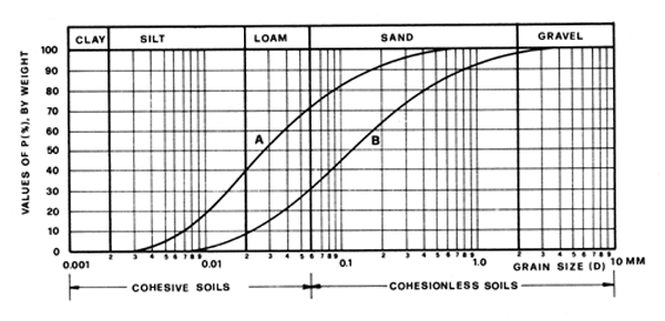
FIGURE 2.
![]()
![]()
![]()