![]()
![]()
![]()
Bhutan (Land of the Thunder Dragon) lies in the eastern part of the Himalayas between 26'5" and 29°N Lat. and 88'5" and 92°E long. It extends about 305 km from east to west and 145 km from north to south, covering an area of approximately 47 000 km2. On all sides awesome natural barriers separate it from the neighbouring countries. To both the west and east, rugged mountain ranges stand between it and the hill districts of India. In the north, the most daunting geographic barrier - the snow-peaked mountains of the Great Himalaya - separates the northern neighbouring Tibet region of the People's Republic of China. In the south the network of mountains comes to an end and merges with the northern plains of West Bengal and Assam Provinces of India. Thus, this mountainous country is totally landlocked.
Bhutan can be broadly divided into three physical zones from south to north:
Southern foothills and plains: the plains of Assam and West Bengal of India gradually rise to a narrow foothill of about 300 m and continue to steep hills to over 1 500 m;
The Inner Himalaya: this area consists of high mountains to over 4 500 m, as well as narrow to wide valleys, e.g., Ha, Paro, Thimbu, Punakha, Wangdi, Phodrang, Tongsa and Tashigang at heights between 1 800 and 2 750 m. Most of the mountains radiate southward forming a large watershed to the principal rivers flowing south;
The Great Himalaya: in the north of Bhutan rises a chain of high peaks of the Great Himalaya. Chomolhari (7 300 m) in the north and Kulakangri (7 497 m) in the east are the highest mountains.
The country is also divided into east and west by a mountain range called Pele-la, which stretches between the two major river systems - the Sankosh and the Manas in the central part of Bhutan.
Although no accurate statistics are available, the total population is estimated to be around 1.2 million with an annual growth of 2.3 percent1. Though the population is most densely distributed in mid-hill valleys and southern plains, the national average population density is only 24/km2.
Usually, the settlements are widely scattered villages comprising about half a dozen houses. More concentrated conglomerations are to be found in the valleys around the old fortresses called Dzongs, which are now being used as administrative or religious centres. There are only two towns - Thimbu, the capital, and Phuntsholing, the gateway of Bhutan, with a population of about 10 000.
Administratively, Bhutan is divided into four territorial divisions or regions -eastern, southern, central and western, covering 18 districts.
Each region varies in size, covering only a few or more districts as follows:
Eastern Region - Tashigang, Mongar, Luntshi and Pema Gyeltshel
Southern Region - Phuntsholing, Gaylegphug, Samdrupjongkhar and Chirang
Central Region - Tongsa, Bumthang, Shemgang and Dagana
Western Region - Wangdiphodrang, Punakha, Thimbu, Gasa, Paro and Ha.
At the district level, the Dzongs are the focal point of administration, as well as for the implementation of the development programmes. The district officer is called Dzongda. The Dzongda is a representative to the Government at the district level and is appointed after the approval of His Majesty the King. Recently, significant steps have been taken to decentralize the control and implementation of development programmes.
Generally, policy guidelines and directives are formulated centrally and conveyed to Dzongdas under which framework the Dzongdas implement the development programme under the technical guidance of Directorates. However, the ideas or suggestions of Dzongdas for improving and adjusting the development programme on the basis of local conditions are always carefully considered.
Besides the large capital investments and development programmes requiring specialized skills, all field projects and service programmes are also administered by the Dzongdas. Thus the Dzongda, the Chief Executive of the district, is a key figure in the implementation of a project or activities at the district level.
To assist the Dzongda in the developmental activities of the district a second man called Ramjam Gom/Ramjam is appointed by the Home Ministry. The Dzongda and the Ramjam Gom/Ramjam are responsible to the Home Ministry.
Each district is divided into several blocks (number of blocks varies from district to district - 18 districts are subdivided into 202 blocks). Each block is represented by a people's representative in the District Development Committee, chaired by the Dzongda. The block representative is called “Gup” in the north and “Mandal” in the south. The Gup or Mandal is elected directly by the people with a term of five years. To communicate with each villager for better programming at the grass-roots level, the Gup or Mandal selects one person from each village as a representative, called “Chupay Gom” or “Chupay Wom” in the north and “Karabari” in the south. The district administration works very closely with the people's representative while planning and implementing projects. The proposed programme of the district or region is thoroughly checked on the spot by the planning commission and the relevant senior authorities.
The climate of Bhutan varies with altitude. It can be divided basically into three district zones.
The area of southern foothills and plains with an altitude of less than 2 000 m has a hot humid tropical climate and vegetation; the Inner Himalaya, up to an altitude of 3 000 m, has a temperate climate; while the northern mountainous strip of the Great Himalaya, with an altitude over 3 000 m, has alpine climate and vegetation. The villages of the Inner Himalaya have cold winters and warm summers.
Generally, the monsoon starts in June and continues until August/September. The southern foothills and plains receive heavy rainfall, about 5 000 mm/year; the Inner Himalaya has a moderate rainfall, approximately, 700 mm/year (as shown in Appendix 3(A) and Appendix 3(B)); while in the high hills it is scanty.
Bhutan, a landlocked country, has vast untapped inland water resources in the form of rivers, lakes and a considerable number of ponds.
The country is cut by numerous rivers and streams, of which four major and three minor river systems are worth mentioning. The major river systems rise from the high snow mountains of northern Bhutan and even from Tibet and begin their long and vigorous journey south into Indian Territory, where they drain into the mighty Brahmaputra River. On their way south as they enter the central region they flow through wider, flatter terrain, providing plentiful water for irrigation in the fertile land of valleys. The rivers are generally named after the valley through which they flow, with the Bhutanese word “Chu”, meaning stream or river, added to the name.
All the three minor rivers, Dhansari, Bar and Mao or Aie, originate from the southern slope of the Inner Himalaya with a good sized watershed.
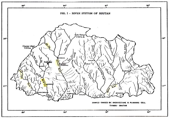
The major rivers of Bhutan are the following (listed from east to west):
Manas or Gongri River
Mo Chu or Sankosh River
Wang Chu or Raidak River
Amo Chu or Torsa River
Manas or Gongri River: The Manas or Gongri River and its main four tributaries -Tashiyong Chu, Kuru Chu, Bamthang or Murchhangpu Chu, and Tongsa or Mangde Chu make a network of rivers in the eastern part of Bhutan and constitute the largest, as well as longest river system in Bhutan. The Manas or Gongri River stretches to 3 200 km2, and is reported to be navigable for about 8 km within Bhutan.
Mo Chu or Sankosh River: The upper stream of this river (Pho Chu) and Punakha or Mo Chu originates from the glaciers of the northern frontier and joins together with Shadang Chu near Punakha. Draining from east to west, it joins Sankosh at Wangdiphodrang and is called Mo Chu or Sankosh. This river constitutes the second biggest river system in Bhutan, with a total length of 1 810 km and it drains a basin of 9 900 km2
Wang Chu or Raidak River; Paro Chu and Thimbu Chu descend from the glaciers in the high mountain ranges northwest of Bhutan and form the Wang Chu just 35 km south of Thimbu. The Ha Chu emerging from the snow clad ranges, flows southeast to meet the Wang Chu and ultimately it drains to India as Wang Chu or Raidak. It covers a total length of nearly 610 km.
Almost all rivers are characterized as clear, with torrential waters, even during the dry months (October-April) of the year. But during the monsoon season, they swell several times because of their big watersheds.
Bhutan has numerous small and medium-sized lakes in the Inner, as well as in the Great Himalaya regions. It has been reported that 59 lakes alone cover a total water surface of about 4 250 ha. Most of the lakes are located along the tourist trekking route above an altitude of 3 500 m. Only a few lakes and oxbows exist below 2 000 m altitude. The list of lakes, area and altitude is given in Appendix 4.
In some districts of the southern plains of Bhutan, a limited number of small ponds exist. The net water surface of these ponds is insignificant at present. However, steadily increasing interest of people to construct ponds for conservation of water for irrigation, as well as fish culture, is encouraging. The existing ponds in various districts, with their total water surface and average size is given in Appendix 5.
Reports on scientific studies on the indigenous fish within the territory of the Kingdom of Bhutan are not available. For the first time, four indigenous fish species (Tor tor, Channa sp., Bagarius yarrelli and Catla buchanani) and an exotic fish species (Salmo trutta) have been reported by the FAO Mission in 1974. A large variety of fish species with varied adaptations to microclimatic conditions and torrential water flow can be expected.
In 1976, under project BHU/75/008, the Fisheries Development Adviser had reported a total of 42 species of fish collected from the rivers and one natural lake, which is listed in Appendix 6. Under the same project, the introduction of common carp (Cyprinus carpio) had also been reported.
The coldwater rivers and the lakes are stocked with trout fingerlings by the Fisheries Unit of the Animal Husbandry Department, and angling is allowed for 8-9 months for recreation. In Bhutan, fishing in the natural waters is regulated under Bhutan Fishing Rules, 1974. Use of any type of net, trap or explosives; and diverting water is strictly prohibited. Hook-and-line fishing is permitted with licence only. In Thimbu, the Forestry Department issues licences for angling and supervises; this is done by Dzongdas in the districts. The rates of licence fees are as follows:
| Period | For local, Indian, Bangladesh and Nepalese Citizens B.N. 1 | For foreigners US$ |
| for one day | 15 | 2.00 |
| for one month | 50 | 6.50 |
| for six months | 100 | 13.50 |
| for one year | 150 | 20.00 |
1 Exchange: US$ 1.00 = Ngultrum 9.18 (April 1981)
Angling equipment is very difficult to obtain, and if available, it is rather expensive. The licence fee is also considered expensive to the general public. Local people are not yet inclined for such recreation or sport. Besides the tourists and the residing foreigners, only a few well-to-do families participate. However, the young generation is now being attracted to this sport.
The Forestry Department, and the district Dzongda reserves the right to issue licences, as well as to control fishing under the Bhutan Fishing Rules, 1974.
![]()
![]()
![]()