Field Document 2
April 1986
T E C H N I C A L C O O P E R A T I O N P R O G R A M M E
| TCP/PNG/4503 (A) Field Document 2 April 1986 |
PAPUA NEW GUINEA
A report prepared for the
Re-establishment of carp fishing project
based on the work of
J. Kövári
Aquaculture Engineer
This report was prepared during the course of the project identified on the title page. The conclusions and recommendations given in the report are those considered appropriate at the time of its preparation. They may be modified in the light of further knowledge gained at subsequent stages of the project.
The designations employed and the presentation of the material in this document do not imply the expression of any opinion whatsoever on the part of the United Nations or the Food and Agriculture Organization of the United Nations concerning the legal of constitutional status of any country, territory or sea area, or concerning the delimitation of frontiers.
FOOD AND AGRICULTURE ORGANIZATION OF THE UNITED NATIONS Rome, 1986
Hyperlinks to non-FAO Internet sites do not imply any official endorsement of or responsibility for the opinions, ideas, data or products presented at these locations, or guarantee the validity of the information provided. The sole purpose of links to non-FAO sites is to indicate further information available on related topics.
This electronic document has been scanned using optical character recognition (OCR) software. FAO declines all responsibility for any discrepancies that may exist between the present document and its original printed version.
1. INTRODUCTION AND TERMS OF REFERENCE
3. HIGHLANDS AQUACULTURE DEVELOPMENT CENTRE AIYURA
4. DESIGN OF REHABILITATION AND EXPANSION OF HAQDECA
4.1 General Outline Layout Plan
4.2 Water Requirements for the Fish Ponds and the Reservoir
4.2.3 Water inflow to the ponds
4.3 Renovation of Existing Ponds
4.4 Improvement of Existing Hatchery
5. ESTIMATED COST OF CONSTRUCTION
6. CONCLUSIONS AND RECOMMENDATIONS
LIST OF FIGURES
1. Highlands Aquaculture Development Centre Aiyura
LIST OF DRAWINGS
2. General outline layout plan
The Government of Papua New Guinea, assisted by the Food and Agriculture Organization of the United Nations under its Technical Cooperation Programme, is engaged in the Re-establishment of carp fishing project (TCP/PNG/4503 (A)) whose main objective is to advise on the re-establishment of carp fishing facilities in the Highlands and on a training programme for management of the fish production.
As part of the project operations, FAO assigned Mr J. Kövári as aquaculture engineer from 10 November to 8 December 1935 with the following terms of reference:
During a period of 4 man-months to prepare plans and supervise the construction work, and specifically:
design an expansion to the present hatchery
design an integrated livestock cum-fish pond
rehabilitate the existing ponds and hatchery
initiate construction of hatchery expansion and the new pond.
Due to the shortening of the consultancy to one month, the terms of reference and site programme were modified with the agreement of Mr Petrous Sagom, Director, Highlands Aquaculture Development Centre, Aiyura (HAQDECA), Department of Primary Industry (DPI), and the following tasks were carried out by the author in Aiyura:
topographic survey of the existing ponds and the area of the proposed expansion to the existing ponds
topographic survey of the existing hatchery
design of the outline, general layout of the existing and proposed new ponds
design of the typical dike sections in the ponds
design of the outline plan of the hatchery for its improvement
estimated cost of construction works.
Common carp aquaculture is the only inland aquaculture taking place in the Highlands of Papua New Guinea. At present, the great majority of fish consumed in the Highlands are canned or frozen products mostly imported from Australia, Japan and New Zealand. There is therefore a great need for an improved supply of fresh fish.
The DPI, Fisheries Division initiated the fish culture programme soon after its formation in 1954. Several fish ponds were constructed by DPI. Four areas where those ponds were established include Kanudi and Bomana in the Central Province, Aiyura in the Eastern Highlands Province and Dobel in the Western Highlands Province. With the exception of the Aiyura ponds, the Dobel, Kanudi and Bomana ponds have now ceased to operate. Until now, carp aquaculture has been mostly carried out by mission schools and some private enterprises. Carp fingerlings have been supplied to them from HAQDECA.
However, this Centre has not been able to satisfy the demand. There is a need to re-activate and nationalize the hatchery, including reconstruction of the existing ponds and build new ponds. Also better fish feed is needed and a training programme to safeguard good management. This should also lead to an enhancement of the supply of fingerlings for distribution, and to an improvement of fish production in the Highlands.
The centre is situated about 11 km southsoutheast of Kainantu, to which it is connected by road. Kainantu itself is 2 hours by road from Goroka and 4 hours from Lae. The fish ponds of the centre are located along the airstrips. Airstrip elevation is about 1 620 m (see Fig. 1).
According to the topographic survey carried out, the contour map including the existing ponds is shown in Drawing No. 1. The local temporary Bench Mark (TBM) with an elevation of 100 m is the top of the tower of the outlet structure in the existing pond Pl.
The existing hatchery building was surveyed and its plan is shown in Drawing No. 4.
Below the black topsoil, at a depth of 40–50 cm clay was found at the pond site. Its colour ranges from yellow to grey. The structure is strong. The consistency of the clay is extremely hard when dry and very sticky when wet. The depth of the water table is not known at the site. The soils investigated are suitable for the construction of the ponds.
Although the local climate is strongly related to topography, the major climatic controls are influenced by seasonal latitudinal movements of two air masses separated by a low pressure belt, the Intertropical Convergence Zone (ITCZ). Northwest winds prevail from late December through to mid-April when the ITCZ is situated over, or to the south of Papua New Guinea. Because the heaviest and most frequent rainfalls are associated with these winds they are frequently called monsoons. Between May and October, when the ITCZ lies to the north of Papua New Guinea it causes dominantly southeasterly winds, also known as trade winds, which blow with great regularity over the Coral Sea. Except in areas affected by strong orographical influences these trade winds do not produce frequent, heavy rainfalls. The short transitional periods between the two seasons are characterized by flukey winds called “doldrums”. These periods occur during late October and November and again during late April and May. In highland areas the seasonality in rainfall is still present, particularly in the east, but is much less marked due to local variations mainly related to topography.
Data were derived from the Aiyura Station No. 200003. The elevation of the station is 1 670 m above sea level.
The mean monthly temperature is between 17.4 and 19.4°C with extremes ranging from -0.6° to 30.8°C. Mean annual temperature is 18.6°C. Average monthly temperature figures are as follows:
| Months | J | F | M | A | M | J | J | A | S | O | N | D | Annual |
| Extreme max. temperature (°C) | 28.7 | 29.9 | 28.3 | 28.4 | 30.8 | 26.4 | 26.1 | 26.4 | 26.7 | 27.8 | 30.0 | 28.9 | 30.8 |
| Mean temp. (°C) | 19.2 | 19.1 | 19.4 | 19.1 | 18.9 | 18.3 | 17.8 | 17.4 | 18.3 | 18.6 | 18.8 | 19.2 | 18.6 |
| Extreme min. temperature (°C) | 5.0 | 4.4 | 9.7 | 5.2 | 6.7 | 4.5 | 6.1 | 4.7 | 4.9 | 5.6 | -0.6 | 4.4 | -0.6 |
The mean daily sunshine (hours) per month and annual total are as follows:
| Months | J | F | M | A | M | J | J | A | S | O | N | D | Annual |
| Daily sunshine per month (h) | 3.8 | 4.1 | 4.2 | 4.5 | 5.4 | 5.3 | 4.6 | 5.6 | 5.1 | 4.6 | 4.8 | 3.5 | 1 688 |
According to the records for the 1937–80 period, the mean annual rainfall is 2 101 mm. Of this, 47 percent falls between December and May. Rainfall figures are as follows:
| Months | J | F | M | A | M | J | J | A | S | O | N | D | Annual |
| Mean rainfall (mm) | 230 | 265 | 258 | 216 | 126 | 91 | 96 | 119 | 122 | 155 | 189 | 234 | 2 101 |
Mean monthly and annual estimates of evaporation from a US class A Pan are as follows:
| Months | J | F | M | A | M | J | J | A | S | O | N | D | Annual |
| Mean evaporation (mm) | 131 | 120 | 136 | 135 | 128 | 119 | 124 | 128 | 151 | 132 | 140 | 137 | 1 581 |
Figures of mean monthly 09.00 and 15.00 h relative humidity (%) and average index of relative humidity are as follows:
| Months | J | F | M | A | M | J | J | A | S | O | N | D | Annual |
| Time | |||||||||||||
| 09.00 h | 79 | 79 | 79 | 77 | 82 | 82 | 81 | 81 | 80 | 80 | 74 | 77 | 79 |
| 15.00 h | 73 | 78 | 75 | 75 | 69 | 70 | 65 | 74 | 75 | 72 | 69 | 80 | 73 |
| Index | 80 | 79 | 79 | 77 | 84 | 79 | 80 | 81 | 80 | 81 | 78 | 81 | 80 |
The general outline layout plan (Drawing No. 2) includes a reservoir of 0.45 ha and four existing ponds of 1.12 ha and 43 new ponds having a water surface area of 4.25 ha of various sizes (Table 1) and the area reserved for the buildings (new hatchery, laboratories, stores, staff quarters, training centre with hostel and classroom, etc.) will be built in the future.
| Mark | Type of ponds | No. | Water Area | |
| Unit (ha) | Total (ha) | |||
| R1 | Reservoir | 1 | 0.45 | 0.45 |
| P2 | Rearing pond | 1 | 0.53 | 0.53 |
| P2 | Rearing pond | 1 | 0.22 | 0.22 |
| P3 | Rearing pond | 1 | 0.20 | 0.20 |
| P4 | Rearing pond | 1 | 0.17 | 0.17 |
| P5–P10 | Broodstock ponds | 6 | 0.25 | 1.50 |
| P11–P19 | Fingerling ponds | 9 | 0.15 | 1.35 |
| P20–P29 | Experimental ponds | 10 | 0.02 | 0.20 |
| P30–P41 | Nursery ponds | 12 | 0.05 | 0.60 |
| P42–P47 | Fingerling ponds | 6 | 0.10 | 0.60 |
| Total water area: | 5.82 ha | |||
The water stored in the reservoir will be used for both the new hatchery through a filter system needed to provide a higher survival rate of hatchlings in the hatchery and the ponds P20–P45 when there is not sufficient water flow in the feeder canal.
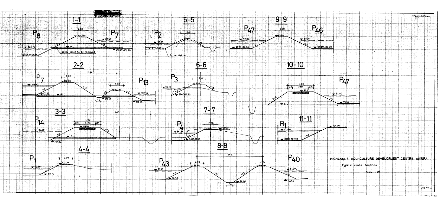
The average water depth in the reservoir and the new ponds would be 1.50 m and 1.20 m respectively. The height of the dikes would provide 50 cm freeboard above the designed water levels of the reservoir and ponds. The width of dike crests would be 2.0 m, and 4.5 m for that of the road dike. The dikes will have interior slopes of 1:2 and of 1:1.5 outside the ponds and drainage canals. Typical cross sections of the dikes are shown in Drawing No. 3. To avoid erosions in the water supply, it is recommended that canals be lined with 15 cm thick concreted gravel and their slopes should be 1:1. All ponds would be provided with inlet and outlet structures. All inlets would be PVC pipe with 100 mm diameter for experimental and nursery ponds and 150 mm diameter for fingerling ponds and 200 mm diameter for broodstock and rearing ponds respectively. Turndown PVC pipe outlets with 150 mm diameter are recommended for the expe- rimental, nursery and fingerling ponds and reinforced concrete structures for the brood stock ponds and reservoir with 30 cm and 40 cm diameter concrete pipes respectively, similar to the outlet structures in the existing ponds P1–P4.
The yearly amount of water required for filling the existing and proposed ponds as well as the reservoir is as follows:
| Ponds | No. | Water Area | Water Depth | Volume | No. of filling | Total volume | |
| unit | total | ||||||
| m2 | m2 | m | m3 | m3 | |||
| P1 | 1 | 5 300 | 5 300 | 1.0 | 5 300 | 2 | 10 600 |
| P2 | 1 | 2 200 | 2 200 | 1.0 | 2 200 | 2 | 4 400 |
| P3 | 1 | 2 000 | 2 000 | 1.0 | 2 000 | 2 | 4 000 |
| P4 | 1 | 1 700 | 1 700 | 1.0 | 1 700 | 2 | 3 400 |
| P5–P10 | 6 | 2 500 | 15 000 | 1.2 | 18 000 | 1 | 18 000 |
| P11–P19 | 9 | 1 500 | 13 500 | 1.2 | 16 200 | 2 | 32 400 |
| P20–P29 | 10 | 200 | 2 000 | 1.2 | 2 400 | 3 | 7 200 |
| P30–P41 | 12 | 500 | 6 000 | 1.2 | 7 200 | 3 | 21 600 |
| P42–P47 | 6 | 1 000 | 6 000 | 1.2 | 7 200 | 2 | 14 400 |
| R1 | 1 | 4 500 | 4 500 | 1.5 | 6 750 | 2 | 13 500 |
| Total amount of water required for filling: | 129 500 | ||||||
| say: | 130 000 | ||||||
As indicated in paragraph 3.4.4, the mean annual evaporation in Aiyura is 1 581 mm taking into account that the soils found at the site have high a clay content, and, therefore, the seepage can be assumed to be 2–3 mm/day. Hence the total annual water losses in the ponds and the reservoir are:
(i) From evaporation
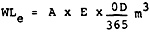
Where:
A = total area of the ponds and reservoir = 5.82 ha = 58 200 m2
E = mean annual evaporation = 1.581 m
OD = assumed yearly operational days = 300 days

(ii) From seepage
WLs = A × s × OD m3
where:
A = total area of the ponds and reservoir = 58 200 m2
s = daily seepage = 0.0025 m/day
WLs = 58 200 × 0.0025 × 300 = 43 650 m3, say 44 000 m3
Total water losses: WLe + WLs = 76 000 + 44 000 = 120 000 m3
The mean annual runoff is calculated applying the equation below:
R = A × Ra × C m3
where:
A = water catchment area of the water supply canal in m2
Ra = mean annual rainfall in m
C = runoff coefficient
Using the above equation with:
Ca = 0.5 km2 = 500 000 m2
Ra = 2 101 mm = 2.10 m
C = 0.401 (woodland)
Hence:
R = 500 000 × 2.10 × 0.40 = 420 000 m3
1 ADCP/REP/94/21, Hydrological Formula, Table 1, page 171
A. Water requirements for operation of the ponds and reservoir:
| (i) | Amount of water required for filling | 130 000 m3 |
| (ii) | Total water losses | 122 000 m3 |
| Total water requirements | 252 000 m3 | |
| B. Water inflow from the water catchment area of the water supply canal | 420 000 m3 | |
It appears that the water requirements may be supplied from the water catchment area of the water supply canal in average years.
The existing four ponds were originally constructed some 30 years ago, hence, all of them have been silted up with 20–40 cm thick silt. All the ponds can be completely drained. As the pond bottom P1 around the outlet was 40 cm deeper than the floor level of its outlet an additional PVC outlet pipe with 15 cm diameter was built to drain the pond properly.
The inner slopes of the ponds are eroded because the dikes were mostly constructed of the top soils excavated from the ponds sites and no proper maintenance has been carried out since their construction. The different slope protections used against erosion have not been applied appropriately.
The following works must be carried out in the existing ponds P1–P4 during their renovation:
After draining and drying-up their bottoms they have to be desilted. The silt excavated from the pond bottoms may be utilized either for fertilization of the horticultural projects adjacent to the fish farm, or for strengthening the outer slopes of the dikes.
The inner slopes of the dikes should be formed with a slope of 1:2. The earth used for sloping the dikes should be thoroughly compacted. Their Proctor density should be minimum 85%. The materials used for dike sloping should be selected clay from the site of the new ponds. The existing slope protection materials may also be used for the new slopes.
The slopes in the ponds to the doorway of the existing duck houses should be 1:3. These slopes should be protected with concreted gravel.
The hatchery building was built in the centre of Highlands Agricultural Experimental Station, Aiyura 1.5 km from the fish ponds. The plan of the hatchery building for its improvement is shown in Drawing No. 4. According to this plan the following improvements are recommended:
The present main water supply pipeline (diameter ¾ inch) has to be changed with one of 2 inch diameter to ensure enough water flow for the proper operation of the hatchery.
Two multipurpose concrete tanks used for holding the spawners, egg hatching and larval nursing should be built in the indoor hatchery building. The proposed tanks can be used for common and Chinese carps as well as Indian major carps.
The section of 10 × 8 cm of the existing drain should be enlarged to 20 × 20 cm to ensure adequate drainage of the tanks.
The existing four fibreglass tanks may be used for larval nursing and experimental works.
To ensure a more successful spawning and a higher survival rate of the hatchlings, 0.5 HP air blower with an output capacity of 75 m3/h at 0.3 kg/cm2 should be provided to the hatchery.
The proposed timetable for hatchling production in the hatchery is given below:
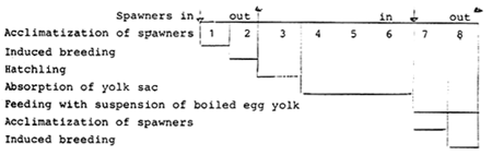
Operation time in the hatchery for one batch of hatchlings
TO = TAS + T1B + TH + TAYS + TF = 1 + 1 + 1 + 3 + 2 = 8 days
Time needed in the hatchery for spawners for the duration of one batch of hatchlings
TS = TAS + T1B = 1 + 1 = 2 days
Interval between two batches of hatchlings
T = To - Ts = 8 - 2 = 6 days
Considering two months (60 days) for peak spawning season, the number of batches of hatchlings may be as follows:
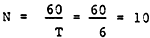
Hatchling production of the hatchery with two multipurpose tanks in each batch is given below:
Volume of one multipurpose concrete tank
V = 1.20 × 3.30 × 0.95 = 3.70 m3
Spawner holding capacity of the tank = 15 kg/m3
| Total holding capacity of the tank = 3.7 × 15 = | 55.5 kg |
| say | 50 kg |
Total number of eggs provided per each batch
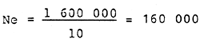
NeB = Sw × M × B × F = 50 × 0.40 × 0.80 × 100 000 = 1 600 000
where:
| Sw = total weight of spawners | = 50 kg |
| M = male percentage | = 40% |
| B = breeding success | = 80% |
| F = practical fecundity | = 100 000 eggs/kg |
| Total number of hatching baskets | = 10 |
| Volume of each hatching basket | = 45 1 |
Maximum loading capacity of one hatching basket = 250 000
Number of eggs placed into each hatching basket
Number of hatchlings from 10 hatching baskets
| NH = 10 × Ne × Fe × Sh = 10 × 160 000 × 0.85 × 0.60 = | 816 000 |
| say | 800 000 |
where:
Fe = fertilization of eggs = 85%
S = survival rate of hatchlings = 60%
| Civil Works | Local |
| (Kina) | |
| Site preparation 1 | 2 820 |
| Desilting existing ponds2 | 3 360 |
| Bank protection of existing ponds3 | 1 770 |
| Renovation of existing ponds4 | 2 850 |
| Earthworks5 | 28 800 |
| Bank protection6 | 8 880 |
| Site finishing7 | 3 600 |
| Surfacing of internal road8 | 4 560 |
| Water supply canals9 | 9 185 |
| Outlets, culverts10 | 10 000 |
| Hatchery building11 | 1 900 |
| Engineering (5%) | 3 885 |
| Sub-total civil works | 81 610 |
| Equipment | |
| Air blower12 | 700 |
| Hatchery building equipment13 | 800 |
| Hatching nets14 | 200 |
| Sub-total equipment | 1 700 |
| Total project cost | |
| Civil works | 81 610 |
| Equipment | 1 700 |
| Total base cost | 83 310 |
| Physical contingencies (20%) | 16 662 |
| Total project cost | 99 972 |
| say | 100 000 |
Footnotes:
1 Cutting and removing vegetation in 60% of total area, 56 400 m2 at K 0.05/m2
5 Excavation of new ponds, reservoir and drainage canals, 24 000 m3 at K 1.5/m3
6 30 cm thick dry gravel pitching 7 400 m2, at K 1.2/m2
8 30 cm thick gravelled surface, 2.5 m wide, 3 800 m2 at K 1.2/m2
Considering the high potential of aquaculture in Papua New Guinea and the increasing interest in carp culture in various provinces (Eastern Highlands Province, Western Highlands Province, Chimbu, etc.), the following recommendations for the aquaculture development in Papua New Guinea are put forward:
HAQDECA may be developed to an aquaculture training centre for extension workers and fish farmers;
HAQDECA can supply fingerlings needed for stocking the existing rural fish ponds and fish ponds which will be built in the Eastern Highlands Province;
For the aquaculture development in Papua New Guinea a detailed survey should be carried out to determine the local aquaculture potential in each province. This survey should cover the location, size, water supply and drainage possibility, and access to fish ponds.
The preparation of detailed plans and commencement of construction works will require three man/months.
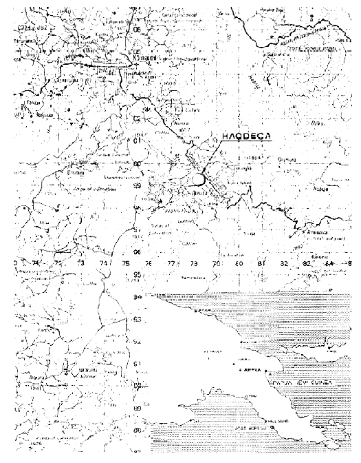
Scale: 1:100 000
Fig. 1 Highlands Aquaculture Development Centre Aiyura. Location map
2. General outline layout plan
![]()