![]()
![]()
![]()
1. GEOGRAPHY AND CLIMATE (after Welcomme, 1979)
Gabon (with a surface area of 257 670 km2) is divided into two main zones:
The climate is hot and humid with a long cold dry season from June to September, a short rainy season from October to December, a short dry season from December to January, and a long rainy season from January to May.
Gabon is very sparsely populated. The main commercial activity is forestry, the majority of the country being thickly wooded.
2. HYDROGRAPHY
2.1 Lakes
There are several freshwater lakes associated with the Ogoouè River flood-plain (Lakes Onangue, Azingo, Anengue, Avanga, Gome, Nkonie and Nguene). Lake Mandji lies on the lower Nyanga River. A complex of four small lakes near Bongo (Lakes Longo-Longo, Kisoro, Mafoumi and Gore) discharge into Ndogo Lagoon.
2.2 Rivers, Floodplains and Swamps
The main river in the country is the Ogoouè which rises in the highlands of the Congo but flows for 820 km through Gabon to discharge into the Atlantic at Port Gentil. There are several other rivers draining this wet and forested country, i.e., the Nyanga, the Benito and a series of tributaries of the Ogoouè. Floodplains are developed on the lower Ogoouè and its tributaries, the Ngounie and the Ivindo.
2.3 Reservoirs: None
2.4 Coastal Lagoons
There are four major (Nkomi, Ngobe, Ndogo and Mbia) and several minor lagoons.
2.5 Aquaculture
There were 2 000 ponds in 1959. In 1967 there were 1 093 ponds with a combined surface area of 35.5 ha. See section 4.1 for aquaculture production by species.
3. FISHERY PRODUCTION/POTENTIAL
3.1 Fish production and per caput supply
Table 1. FISH PRODUCTION AND PER CAPUT SUPPLY - Gabon, 1970–1987
| Nominal Production (including exports) (t) 2 | Nominal Consumer Supply (including exports) (kg/person) | ||||||||
| Year | Population '000 1 | Inland capture | Aquaculture 3 | Marine capture 6 | Total | Inland capture | Aquaculture 3 | Marine capture | Total |
| 1970 | 950 | 400 | - 4 | 3 600 | 4 000 | 0.4 | - | 3.8 | 4.2 |
| 1971 | 960 | 400 | - | 3 600 | 4 000 | 0.4 | - | 3.8 | 4.2 |
| 1972 | 971 | 400 | - | 3 600 | 4 000 | 0.4 | - | 3.7 | 4.1 |
| 1973 | 981 | 400 | - | 4 500 | 4 900 | 0.4 | - | 4.6 | 5.0 |
| 1974 | 992 | 400 | - | 4 500 | 4 900 | 0.4 | - | 4.5 | 4.9 |
| 1975 | 1 003 | 400 | - | 5 656 | 6 056 | 0.4 | - | 5.6 | 6.0 |
| 1976 | 1 015 | 400 | - | 5 656 | 6 056 | 0.4 | - | 5.6 | 6.0 |
| 1977 | 1 027 | 400 | - | 5 656 | 6 056 | 0.4 | - | 5.5 | 5.9 |
| 1978 | 1 039 | 400 | - | 12 950 | 13 350 | 0.4 | - | 12.4 | 12.8 |
| 1979 | 1 052 | 1 800 | - | 19 200 | 21 000 | 1.7 | - | 18.3 | 20.0 |
| 1980 | 1 064 | 1 800 | - | 18 000 | 19 800 | 1.7 | - | 16.9 | 18.6 |
| 1981 | 1 081 | 1 800 | - | 17 700 | 19 500 | 1.7 | - | 16.3 | 18.0 |
| 1982 | 1 098 | 1 792 | 8 5 | 18 800 | 20 600 | 1.6 | 0.007 | 17.1 | 18.7 |
| 1983 | 1 115 | 1 792 | 8 5 | 17 600 | 19 400 | 1.6 | 0.007 | 15.8 | 17.4 |
| 1984 | 1 133 | 1 798 | 2 5 | 19 200 | 21 000 | 1.6 | 0.002 | 16.9 | 18.5 |
| 1985 | 1 151 | 1 798 | 2 5 | 19 200 | 21 000 | 1.5 | 0.002 | 16.7 | 18.2 |
| 1986 | 1 174 | 1 976 | 3 5 | 18 810 | 20 789 | 1.7 | 0.003 | 16.0 | 17.7 |
| 1987 | 1 198 | 1 897 | 3 5 | 19 000 | 20 900 | 1.6 | 0.003 | 15.8 | 17.4 |
1 Source: FAO
2 Source: FAO Fisheries Department FISHDAB; see also section 4.1
3 included in “Inland capture” if not specified.
4 - = data not available.
5 Vincke, 1989, pers.comm.
6 From 1980 to 1983, marine exports were as follows: 1980: 166 t; 1981: 2 079 t; 1982: 1 422 t; 1983: 1 457 t.
Data for artisanal fisheries estimated in collaboration with Gabonese fishery authorities. Industrial catch in 1986 recorded as 8 600 t.
3.2 Inland catch range and potential yield
No detailed data available for Lakes Anengue, Azingo, Mandje and Onangue; Benito and Ogoouè Rivers; Mbia, Ndogo, Ngobe and Nkomi Lagoons.
Total annual yield: 1 800 to 1 900 t (1979–1987)
Potential annual yield: 2 500 t (estimate based on 500 t inland freshwater and 2 000 t in lagoons).
4. STATE OF THE FISHERY (adapted from Welcomme, 1979)
4.1 Yield
For a country with such an extensive network of inland waters, the 1970–77 nominal catch of 400 t quoted in Table 1 seems very low. Mougnassa (1977) advances a more reasonable figure of about 30% of the total national catch (6 056 t), which would put the recent yield at 1 800 t, a figure completely consistent with the 1 485 inland fishermen listed as working in the country.
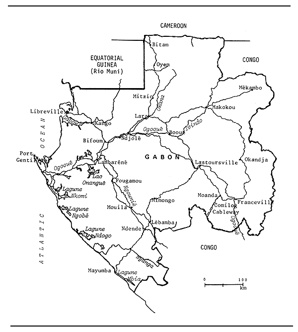
Fig. 1. MAP OF GABON
Even at 1 900 t (in 1986–87) the yield of the inland fisheries appears very low considering the extent of the resource. It may safely be suggested, therefore, that the fishery is underdeveloped - an observation confirmed by Mougnassa (1977), who describes the fishery as developing.
There is a small aquaculture sector which produces about 2–8 t of fish per year (1982–1987).
Production, by species, from aquaculture in Gabon from 1982 to 1987 is reported by Vincke (1989, pers.comm.) as follows:
| Species | 1982 | 1983 | 1984 | 1985 | 1986 | 1987 |
| Oreochromis niloticus | 8 t | 8 t | 2 t | 2 t | 3 t | 3 t |
4.2 Factors influencing yield
At present human and sociological factors seem to be keeping the fishery at a low level of productivity. Fishermen are not abundant and are badly equipped. There is little infrastructure in the form of training establishments or marketing networks or sales facilities for fishing gear.
4.3 Future development possibilities
It is fairly certain that the inland fisheries of Gabon will develop in the future. More catch can be anticipated from the natural waters and, with the recent introduction of aquaculture, the production of freshwater fish could probably be increased consistently.
5. KEY BIBLIOGRAPHY
Collart & Giudicelli, 1984
Deceuninck, 1988
6. WATER BODIES DIRECTORY
| Lakes | ||
| Anengue | Bongo Lake Complex | Onangue |
| Azingo | Mandje | |
| Rivers | ||
| Benito | Ogoouè | |
| Lagoons | ||
| Mbia (= Mbanio) | Ngobe | |
| Ndogo | Nkomi |
LAKE ANENGUE
| Geographical data | |
| Location: | Gabon - 1° 8'S; 9° 28'E |
| Surface area: | 88 km2 |
| Max. length: | 18 km |
| Max. width: | 7 km |
| Inflowing river: | Ogooué (lateral spillage) |
| Outflowing river: | Ogooué |
LAKE AZINGO
| Geographical data | |
| Location: | Gabon - 0° 34'S; 10° 2'E |
| Surface area: | 106 km2 |
| Max. length: | 19 km |
| Max. width: | 8 km |
| Inflowing river: | Ogoouè (lateral spillage) |
| Outflowing river: | Ogoouè |
BONGO LAKE COMPLEX
| Geographical data | |
| Location: | Gabon - 2° 15' -22'S; 10° 6'-11'E |
| Special features: | a tandem series of four small lakes (Longo-Longo, Kivoro, Mafoumi and Gore, in upstream to downstream order). The outflow from Lake Gore enters Ndogo Lagoon. |
LAKE MANDJE
| Geographical data | |
| Location: | Gabon - 2° 50'S; 10° 22'E |
| Surface area: | 45.5 km2 |
| Max. length: | 13 km |
| Max. width: | 5 km |
| Inflowing river: | Nyanga (lateral spillage) |
| Outflowing river: | Nyanga |
LAKE ONANGUE
| Geographical data | |
| Location: | Gabon - 0° 58'S; 10° 4'E |
| Altitude: | 30 m asl |
| Surface area: | 167.5 km2 |
| Max. length: | 32 km |
| Max. width: | 20 km |
| Inflowing river: | Ogoouè (lateral spillage) |
| Outflowing river: | Ogoouè |
BENITO RIVER
(International water)
| Geographical data | |
| Source: | northern Gabon |
| Altitude: | 700 m asl |
| Total length: | 365 km |
| Countries traversed: | Equatorial Guinea (Rio Muni), Gabon |
| Discharges to: | Atlantic Ocean - 1° 35'N; 9° 37'E |
OGOOUE RIVER
(International water)
| Geographical data | |
| Source: | Congo (Leketi, Zala and Massa Mountains) |
| Altitude: | 880 m asl |
| Total length: | 920 km (100 km in Congo, 820 km in Gabon) |
| Drainage area: | 205 000 km2 (at Lambarene) |
| Countries traversed: | Gabon, Congo |
| Major tributaries: | Ivindo, Ngouniè, Ofoouè |
| Discharges to: | Atlantic Ocean - 1° 2'S; 8° 53'E |
| Volume of discharge at mouth: | |
| 1 950–7 340 m3/sec (mean monthly); | |
| 13 500 m3/sec (maximum) | |
| Flood regime: | bimodal flood with peaks in April-May and November-December |
| Special features: | large floodplain in lower reach with several associated lakes (Anengue, Ovanga, Onangue, Gome, Nkome, Azingo and Nguene). Other swampy/floodplain depressions associated with Ngoumiè and Ivindo tributaries (the latter mostly in Congo). |
MBIA (= MBANIO) LAGOON
| Geographical data | |
| Location: | Gabon - 3° 23–46'S; 10° 40-11° 10'E |
| Surface area: | 242 km2 |
| Max. length: | 69 km |
| Max. width: | 5 km |
NDOGO LAGOON
| Geographical data | |
| Location: | Gabon - 2° 23'–40'S; 9° 38'–10° 10'E |
| Surface area: | 582 km2 |
| Max. length: | 64 km |
| Max. width: | 13 km |
| Inflow: | discharge from Bongo Lake Complex |
NGOBE LAGOON
| Geographical data | |
| Location: | Gabon - 1° 51'–2° 6'S; 9° 16'–36'E |
| Surface area: | 402 km2 |
| Max. length: | 41 km |
| Max. width: | 14 km |
NKOMI LAGOON
| Geographical data | |
| Location: | Gabon - 1° 20–44'S; 9° 1–36'E |
| Surface area: | 806 km2 |
| Max. length: | 72 km |
| Max. width: | 16 km |
7. BIBLIOGRAPHY
Barret, 1983
Collart & Giudicelli, 1984
Deceuninck, 1988
Mougnassa, 1977
Welcomme, 1972; 1979
1. GEOGRAPHY AND CLIMATE
The Gambia (surface area of 10 000 km2) is a long, low-lying strip of land flanking the Gambia River for the lower 480 km of its course. Nowhere does the land rise above 40 m in altitude. Much of the river is estuarine and mangroves penetrate upstream for a considerable distance. Salt water penetrates 150 km upstream in the floods and 200 km during the dry season.
The winters are cool and summers warm. The climate is dry for most of the year, with a single rainy season lasting from June to September. The flood of the river coincides with this.
The Gambia is a wholly agricultural country whose activities are confined to the banks of the river. There is some rice culture, but little flood control or irrigation. On the whole the flood regime still controls the activities of the rural communities.
2. HYDROGRAPHY
2.1 Lakes: There are no lakes.
2.2 Rivers, Floodplains and Swamps
The country is dominated by one river, the Gambia, entering from Senegal. During the rainy season about 40% of the country is flooded.
2.3 Reservoirs: None
2.4 Coastal Lagoons
There is one small lagoon on the north shore of the Gambia River estuary near Njakunda.
2.5 Aquaculture
Vincke (1989, pers.comm.) estimates the following aquaculture production units existing in 1985: breeding centres: 1 (surface area: 1 ha); family type ponds: unknown.
3. FISHERY PRODUCTION/POTENTIAL
3.1 Fish production and per caput supply
(See Table 1)
3.2 Inland catch range and potential yield
Annual catch: Gambia River (1977–82): 1 423–3 508 t.
Total annual yield: 1 400–3 500 t
Potential annual yield: 2 000–8 000 t (Welcomme, 1979)
Table 1. FISH PRODUCTION AND PER CAPUT SUPPLY - Gambia, 1970–1987
| Nominal Domestic Production (excluding exports) (t) 2 | Nominal Consumer Supply (excluding imports and exports) (kg/person) | ||||||||
| Year | Population '000 1 | Inland capture | Aquaculture 3 | Marine capture 6 | Total | Inland capture | Aquaculture 3 | Marine capture | Total |
| 1970 | 469 | 800 | - 4 | 5 000 | 5 800 | 1.7 | - | 10.7 | 12.4 |
| 1971 | 479 | 800 | - | 5 200 | 6 000 | 1.7 | - | 11.0 | 12.5 |
| 1972 | 490 | 800 | - | 5 200 | 6 000 | 1.7 | - | 10.6 | 12.2 |
| 1973 | 501 | 800 | - | 9 600 | 10 400 | 1.6 | - | 19.2 | 20.8 |
| 1974 | 512 | 800 | - | 9 995 | 10 795 | 1.6 | - | 19.5 | 21.1 |
| 1975 | 524 | 800 | - | 9 995 | 10 795 | 1.5 | - | 19.1 | 20.6 |
| 1976 | 536 | 800 | - | 9 995 | 10 795 | 1.5 | - | 18.6 | 20.1 |
| 1977 | 548 | 870 | - | 22 131 | 23 001 | 1.6 | - | 40.4 | 42.0 |
| 1978 | 560 | 1 000 | - | 27 724 | 28 724 | 1.8 | - | 49.5 | 51.3 |
| 1979 | 572 | 2 700 | - | 8 443 | 11 143 | 4.7 | - | 14.8 | 19.5 |
| 1980 | 583 | 2 700 | - | 10 565 | 13 265 | 4.6 | - | 18.1 | 22.7 |
| 1981 | 595 | 2 700 | - | 11 368 | 14 068 | 4.5 | - | 19.1 | 23.6 |
| 1982 | 607 | 2 700 | 0 5 | 6 512 | 9 212 | 4.4 | 0 | 10.7 | 15.1 |
| 1983 | 618 | 2 698 | 2 5 | 8 953 | 11 653 | 4.4 | 0.003 | 14.5 | 18.9 |
| 1984 | 630 | 2 699 | 1 5 | 9 182 | 11 882 | 4.3 | 0.001 | 14.6 | 18.9 |
| 1985 | 643 | 2 700 | 0 5 | 8 012 | 10 712 | 4.2 | 0 | 12.5 | 16.7 |
| 1986 | 657 | 2 700 | 0 5 | 10 562 | 13 262 | 4.1 | 0 | 16.1 | 20.2 |
| 1987 | 671 | 2 700 | 0 5 | 11 676 | 14 376 | 4.0 | 0 | 17.4 | 21.4 |
1 Source: FAO
2 Source: FAO Fisheries Department FISHDAB
Excludes catches by Seagull Goldstores Ltd. No comprehensive catch assessment survey for inland waters. Data from 1979 estimated on basis of special study undertaken in 1979.
3 included in “Inland capture” if not specified.
4 - = data not available.
5 Vincke, 1989 (pers.comm.)
6 Exports are not exactly known, but are thought to be small.
4. STATE OF THE FISHERY
4.1 Yield
It is evident that the recorded catch is low compared with the empirically predicted state of the resource. The Gambia River can be divided into two main fisheries:
Two estimates of potential can be advanced. First, simply on the basis of the length of the river, one would expect to find at least 2 300 t of fish per year. The area is, however, largely estuarine and also has extensive upstream floodplains which, on the basis of 55 kg/ha (mean derived from other similar systems), would be expected to produce about 11 000 t/yr. These two estimates are disparate and, because of the lack of fundamental research work on the river, it is difficult to decide which corresponds best to the real situation. The catch levels of 1977–82 would indicate a higher level of catch than that predicted by a simple river length model.
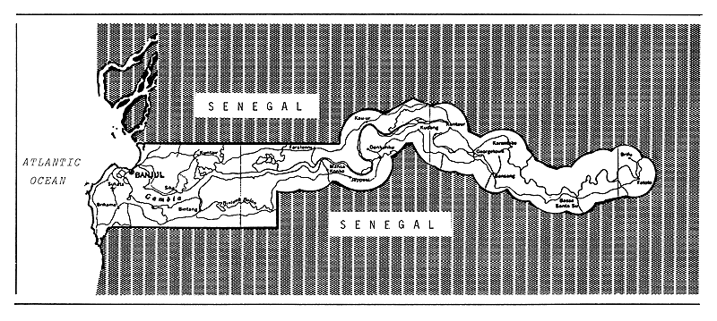
Fig. 1. MAP OF THE GAMBIA
Vincke (1989, pers.comm.) gives the following data for aquaculture production (1982–87) by species:
| Species | 1982 | 1983 | 1984 | 1985 | 1986 | 1987 |
| Oreochromis niloticus | 0 | 2 t | 1 t | 0 | 0 | 0 |
4.2 Factors influencing yield
Factors which may influence yield in the future are plans to control the flood of the Gambia River, which would cut down on the amount of floodland available to the fish.
4.3 Future development possibilities
The recorded catch of inland fish in Gambia may rise in the next few years, due not so much to any actual increases in production as to improvements in statistical systems which will enable better estimates of catch.
5. KEY BIBLIOGRAPHY: None.
6. WATER BODIES DIRECTORY
GAMBIA RIVER
(International water)
| Geographical data | |
| Source: | Fouta Djallon (Guinea) |
| Altitude: | 1 100 m |
| Total length: | 1 120 km (last 480 km in Gambia; 200 km in Guinea) |
| Drainage area: | 77 000 km2 |
| Countries traversed: | Gambia, Guinea, Senegal |
| Discharges to: | Atlantic Ocean at Bathurst, Gambia - 12° 23'N, 16° 20'W |
| Special features: | in Gambia most of the banks are flooded during the rains, and the estimated area of waters at peak floods of 2 000 km2 covers about 40% of the area of Gambia. There is a small lake/lagoon on the northshore floodplain river Njakunda. The saline downstream reaches of the river are lined with mangroves and are generally estuarine in character. |
| Physical and chemical data | |
| Temperature: | about 20° C |
| pH: | 6.3 |
Fisheries data
No. of fish species: 81
Total annual catch and effort:
| Year | Total catch (t) | No.of fishermen | No.of boats |
| 1977 | 3 171 | - | - |
| 1978 | 3 198 | - | - |
| 1979 | 2 795 | - | - |
| 1980 | 2 596 | - | - |
| 1981 | 1 423 | 564 | 554 |
| 1982 | 3 508 | - | - |
7. BIBLIOGRAPHY
Welcomme, 1979
1. GEOGRAPHY AND CLIMATE (Welcomme, 1979)
Ghana (with a surface area of 238 539 km2) is divided into three main regions. There is a narrow sandy coastal plain, behind which there is a range of low but abrupt hills; to the north there are low-lying plains. The southwestern part of the country is densely forested, and to the north are bush savanna and grasslands.
The coastal belt is warm, fairly dry to the east, but becoming more humid to the west. The forest zone is very humid but the rest of the country becomes progressively more arid northward. In the south there are two rainy seasons (March-June and September-November), separated by dry periods. In the north the two wet seasons tend to be closer together and merge into one (May-October).
Ghana is almost entirely agricultural, except for some industries which are located mostly at Tema. The Akosombo Dam was built mostly to provide power for industrialization, especially the Volta Aluminium Company (Valco) based at Tema, which consumes 60% of this power. Ghana also supplies power to Togo and Benin. Forestry is also an important activity in the southwest of the country.
2. HYDROGRAPHY (after Welcomme, 1979, and Balarin, 1988)
2.1 Lakes
The only natural freshwater lake of any size in the country is Lake Bosumtwi, a crater lake situated in Ashanti Region. This supports some commercial fishing activity.
2.2 Rivers, Floodplains and Swamps
Ghana is extremely well watered and is drained principally by the Black, White and Red Volta Rivers and the Oti River, but several smaller water courses, including the Pra, Tano and Bia drain the forested southwestern areas (see Fig. 1, Table 1). Flooding on the lower Volta River is now controlled by the Akosombo Dam.
The hydrology of the Volta River is well documented by Nerguaye-Tetteh et al., (1984). The most important flow is from the Oti. Peak flows are between September and October, with an annual average of 1 230 m3/s. Examining past trends, it is noted that from 1936 to 1958 conditions altered fairly evenly between wet and dry years. However, from 1962 to 1971 the flow regime was relatively wet; then from 1972 to 1978 it became dry again, followed by two wet years. Thereafter 1981 to 1983 were the driest years of the series, emphasizing the effect of the Sahelian drought. In general, water quality is good for both irrigation and livestock uses.
Extensive marsh and swamp occur around the borders of most of the coastal lagoons but no quantified data is available.
2.3 Reservoirs
Ghana contains the largest man-made reservoir in Africa, the 8 482 km2 Volta Reservoir. The reservoir, which is backed up behind the Akosombo high dam, is over 400 km long and has drowned much of the lower courses of the various rivers of the Volta system. It is used as a water store to generate electricity, but the severe drought of 1981–83 drastically reduced the output.
Table 1. MAJOR RIVER SYSTEMS AND HYDROLOGICAL ZONES - GHANA
(Sources: Govt. of Ghana, 1966; Welcomme, 1972; Nerguaye-Tetteh et al., 1984)
| Drainage Basin 1 | Major River Systems | Flow Range (Annual mean) m3/S × 103 | No. of Fish Species | ||
| Name | Length km | Catchment km2 2 | |||
| 1 | Volta Basin | 165 700 | |||
| (149 600) | (0.057) | ||||
| 1a | Black Volta | 650 | 35 105 | 0.01–1.10 | 96 |
| (0.135) | |||||
| 1b. | White Volta | 45 800 | 0.1–1.41 | ||
| (72 900) | (0.112) | ||||
| 1c. | Oti | 900 | 16 215 | 0.01–1.27 | |
| 1d. | Volta | 68 580 | (0.141) | 70 | |
| 2. | Bia | 200 | 6 470 | 0.13 | 32 |
| (9 500) | (0.08) | ||||
| 3. | Tano | 625 | 1 490 | 0.03–0.78 | |
| (16 000) | (0.13) | ||||
| 4. | Ankobra | 8 460 | 0.11 | ||
| 5. | Pra | 445 | 23 200 | 0.03–0.92 | |
| (0.24) | |||||
| 6. | Ochi-Amissa | 1 370 | 0.05 | ||
| 7. | Ochi-Nakwa | 1 500 | 0.05 | ||
| 8. | Ayensu | 1 700 | 0.001–0.06 | ||
| 9. | Densu | 2 550 | |||
| 10. | Subri-Amansuri | 840 | |||
| 11. | Butre | 460 | |||
| 12. | Kakum-Saruwi | 980 | |||
| 13. | Todzie | 1 860 | 0.06 | ||
| 14. | Aka (Keta Lagoon) | 1 720 | |||
| 15. | Minor Coastal Streams | 6 150 | |||
| Total | 237 870 | ||||
1 Numbers refer to Figure 1.
2 Value in parentheses is total drainage area.
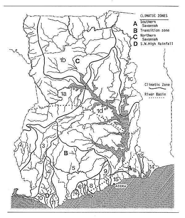
Fig. 1. CLIMATIC ZONES AND MAJOR RIVER SYSTEMS (see Table 1)
(World Bank, 1985 and Govt. of Ghana, 1966)
Table 2. MORPHOLOGICAL DATA FOR MAJOR LAKES, RESERVOIRS AND LAGOONS
(Balarin, 1988)
| Name (date constructed) | Ref. | Description | Fishery potent. t/yr | Fish species | Use* | Water temp °C | |||
| Volume 103m3 | Area km2 e | Alt. (m) | Mean depth (m) | ||||||
| Volta (1966) | a b | 165.0 | 8 482 | 85 | 19 | 50 000 | 70 | f,p,i | 27–32 |
| Bosumtwi | a | 49 | 107 | 600 | 27.9 | ||||
| Weija (1974) | c | 35–57 | 14.1 | 420 | |||||
| Barekese (1970) | c | 6.4 | 80 | ||||||
| Tono (1975) | d | 0.09 | 18.6 | 200 | 225 | ||||
| Vea (1965) | d | 0.02 | 4.0 | 200 | 45 | ||||
| Kpong (1981) | 36.5 | p,i | |||||||
| Nasia | |||||||||
| Golinga | |||||||||
| Tanogo | |||||||||
| Subinia | |||||||||
| Akumandan | |||||||||
| Dawhenya | 2.2 | 30 | |||||||
| Afife | 5.5 | 70 | |||||||
| Lagoons | |||||||||
| Keta | 330 | 4 000 | 27.7 | ||||||
| Sakumo | a | 10 | 0 | 0.5–10 | 120 | ||||
| Songaw | a | 18 | 220 | ||||||
| Unvoiye | a | 11.1 | 140 | ||||||
| Juen | |||||||||
| Sakumor-choko | 23 | 290 | |||||||
| Mukwe | 0.5 | ||||||||
| Nakwa | 6.5 | 80 | |||||||
| Nuyi | 8 | 100 | |||||||
* f = fishery; i = irrigation; p = power generation
Sources:
a Welcomme (1972)
b Czernin-Chudenitz (1971)
c Allen & Gaudet (1978)
d ICOUR (1985)
e Adumua-Bossman & Mensah (1980)
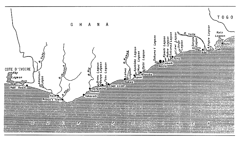
Fig. 2. THE PRINCIPAL LAGOONS OF GHANA
(from M.A. Mensah, in Weigel, 1985)
Downstream from Volta Reservoir is the newly created Kpong Reservoir. Other smaller reservoirs are Vea and Tono, both in the Upper East Region; Weija and Dawhenya, located near Accra; and Barakese, near Kumasi.
Table 2 gives some morphological data for major reservoirs; Table 3 gives an estimate of the total number of reservoirs, from 1967 to 1982. FAO (1982) lists 300 reservoirs of 2.5 to 1 860 ha in Upper East and West alone, and 120 being planned.
Table 3. ESTIMATES OF NUMBERS OF RESERVOIRS - GHANA
(Balarin, 1988)
| Region | Location | 1967 | 1969 | 1974 | 1982 |
| Upper East | Bawku-Bolgatanga-Nawrongo | 150 | 130 | 169 | |
| Northern | Lawra-Wa-Damango-Tamale | 17 | 90 | 90 | |
| Volta | Ho | 51 | 51 |
Sources: FD, 1975; Denyoh, 1967; USAID, 1969
2.4 Coastal Lagoons (see Fig. 2)
There are about 50 brackishwater lagoons situated along the coast of Ghana, with a total surface area of some 400 km2 (FAO/IFAD, 1981). These are described in detail by Mensah (1979). The largest of these is the Keta Lagoon, situated around the delta of the Volta River. The nature of this lagoon has changed considerably since the closure of the Akosombo Dam; the former periodic flushes of freshwater do not now occur, and the lagoon has become more saline as a consequence.
The salinity and temperature of the lagoons vary with opening to the sea and flooding of inflowing rivers; open lagoons generally tend to be more productive. Table 2 gives the surface area and fishery potential of the major lagoons.
2.5 Aquaculture
A recent survey published by CSIR (1984) estimates that 1 135–1 400 ponds exist, covering an area of 77.8 ha (i.e., 555–685 m2 average size), of which 70% are household units and 30% community ponds (Table 4).
Table 4. FISH POND DISTRIBUTION IN GHANA, 1982/83
(Abstracted from CSIR, 1986)
| Region | Area (ha) | Household (%) | Community (%) | Estimated Total No. |
| Upper East | 3.5 | 100 | 0 | 0–10 |
| Upper West | - | |||
| Northern | 3.6 | 90 | 10 | 11–30 |
| Brong-Ahafo | 0.8 | 50 | 50 | 11–30 |
| Ashanti | 9.9 | 20 | 80 | 151–170 |
| Volta | 5.4 | 33 | 77 | 70–150 |
| Western | 3.6 | 85 | 15 | 70–150 |
| Central | - | 77 | 33 | 11–30 |
| Eastern | 9.3 | 90 | 10 | 11–30 |
| Greater Accra | 41.7 | 85 | 15 | >800 |
| Total | 77.8 | 70 | 30 | 1 135–1 400 |
3. FISHERY PRODUCTION/POTENTIAL
3.1 Fish production and per caput supply
Table 5. FISH PRODUCTION AND PER CAPUT SUPPLY - Ghana, 1970–1987
| Nominal Production (including exports) (t) 2 | Nominal Consumer Supply (including exports) (kg/person) | ||||||||
| Year | Population '000 1 | Inland capture | Aquaculture 3 | Marine capture 4 | Total | Inland capture | Aquaculture 3 | Marine capture | Total |
| 1970 | 8 614 | 30 000 | - 5 | 141 500 | 171 500 | 3.5 | - | 16.4 | 19.9 |
| 1971 | 8 839 | 40 000 | - | 176 400 | 216 400 | 4.5 | - | 20.0 | 24.5 |
| 1972 | 9 070 | 32 000 | - | 249 200 | 281 200 | 3.5 | - | 27.5 | 31.0 |
| 1973 | 9 307 | 41 300 | - | 182 400 | 223 700 | 4.4 | - | 19.6 | 24.0 |
| 1974 | 9 551 | 37 300 | - | 182 213 | 219 513 | 3.9 | - | 19.1 | 23.0 |
| 1975 | 9 800 | 41 945 | - | 212 570 | 254 515 | 4.3 | - | 21.7 | 26.0 |
| 1976 | 10 129 | 41 945 | - | 195 752 | 237 697 | 4.1 | - | 19.3 | 23.4 |
| 1977 | 10 469 | 40 704 | - | 226 198 | 266 902 | 3.9 | - | 21.6 | 25.5 |
| 1978 | 10 821 | 36 261 | - | 222 084 | 258 345 | 3.3 | - | 20.5 | 23.8 |
| 1979 | 11 184 | 39 368 | - | 197 166 | 236 534 | 3.5 | - | 17.6 | 21.1 |
| 1980 | 11 560 | 40 000 | - | 191 891 | 231 891 | 3.5 | - | 16.6 | 20.1 |
| 1981 | 11 940 | 40 000 | - | 199 894 | 239 894 | 3.4 | - | 16.7 | 20.1 |
| 1982 | 12 332 | 41 873 | 127 6 | 200 680 | 242 680 | 3.4 | 0.01 | 16.3 | 19.7 |
| 1983 | 12 737 | 42 675 | 325 6 | 207 898 | 250 898 | 3.4 | 0.03 | 16.3 | 19.7 |
| 1984 | 13 156 | 40 550 | 450 6 | 228 518 | 269 518 | 3.1 | 0.03 | 17.4 | 20.5 |
| 1985 | 13 588 | 42 643 | 357 6 | 232 934 | 275 934 | 3.1 | 0.03 | 17.1 | 20.3 |
| 1986 | 14 052 | 52 679 | 321 6 | 267 713 | 320 713 | 3.7 | 0.02 | 19.1 | 22.8 |
| 1987 | 14 532 | 53 614 | 386 6 | 317 817 | 371 817 | 3.7 | 0.03 | 21.9 | 25.6 |
1 Source: FAO
2 Source: FAO Fisheries Department FISHDAB
3 included in “Inland capture” if not specified
4 Includes landings of Ghananian flag vessels in the Gambia.
Catch by Ghanaian artisanal fishermen considerably greater than fish landed in Ghana, as Ghanaian fishermen operate from beaches along the West African coast, notably in Liberia, Gambia, Togo, Benin and Sierra Leone. Catches by these canoes included in totals for the respective countries.
From 1980 to 1983, marine exports were as follows: 1980: 29 600 t; 1981: 34 300 t; 1982: 32 100 t; 1983: 22 390 t.
5 - = data not available
6 Vincke, 1989, pers. comm.
3.2 Inland catch range and potential yield
Table 6. INLAND CATCH RANGE AND POTENTIAL YIELD
| Water body | Period | Annual catch range (t) | Potential annual yield (t) | |
| Volta River | 1960's | 4 000 1 | - | |
| Volta Reservoir | 1970–79 | 35 900–41 945 | 39 000 2 | |
| 50 000 3 | ||||
| Sakumo-Tema Lagoon | 1971 | 15 | - | |
| No information available for | ||||
| Lake Bosumtwi; | ||||
| Rivers Bia, Black Vota, Oti, Pra, Red Volta, Tano, White Volta; | ||||
| Reservoirs Barekese, Dawhenya, Kpong, Tono, Weija; | ||||
| Lagoons Avu, Keta, Mukwe, Sakumo-Accra, Songaw, Unvaiye. | ||||
| Total Rivers | - | 4 000 4 | ||
| Total Lagoons | - | 15 000 5 | ||
1 River clam catch only
2 Welcomme, 1972
3 Denyoh (pers.comm.)
4 Balarin, 1988
5 FAO, 1976
| Total annual yield: | 1980–1985: 40 000 t (see Table 5) 1986–1987: 53 000 t (see Table 5) |
| Potential annual yield: | 40 000–69 000 t (Balarin, 1988) 65 000 t (Denyoh, pers.comm.) |
4. STATE OF THE FISHERY (adapted from Welcomme, 1979; and Balarin, 1988)
4.1 Yield
The main feature of the inland fishery is the Volta Lake, which has 920 fishing villages and 12 500 small canoes; it produces an estimated 40 000 t/yr (FAO, 1978a), employing about 20 000 fishermen (FAO, 1981).
The catch from the Volta Reservoir reached a peak of 61 783 t in 1969 after the reservoir filled in 1964. Subsequently there has been a decline to 36 000–42 000 t, which seems to be the stabilization level. Catch from other inland waters and the coastal lagoons may be estimated at some 7 000 t.
Denyoh (1985) gives the most recent documented statistics of aquaculture production. Government and private fish ponds total 120 ha and produce 325 t annually (2.7 t/ha/yr average yield). In addition, there are 15 ha of Fisheries Department ponds to provide fingerlings for dam stocking. Table 7 gives the production by species from 1982 to 1987.
Table 7. AQUACULTURE PRODUCTION, BY SPECIES (t)
| Species | 1982 | 1983 | 1984 | 1985 | 1986 | 1987 |
| Oreochromis, Sarotherodon spp. | 25 | 82 | - | 64 | - | - |
| Clarias gariepinus | 13 | 50 | 60 | 36 | 96 | 116 |
| Oreochromis niloticus | 89 | 193 | 390 | 257 | 225 | 270 |
| Total | 127 | 325 | 450 | 357 | 321 | 386 |
Source: Vincke, 1989, pers.comm.
Pautzke and Crowther (1968) describe a 4 000 t/yr freshwater clam fishery in the lower Volta River below Akuse: Egeria radiata were harvested as young clams in December-January and stocked further upstream at 1 500/m2 to be harvested when grown in May-June. The fate of this activity due to the damming is not known.
4.2 Factors influencing yield
The yield of Volta Reservoir has followed the classic pattern of peak and stabilization. The dam has undoubtedly affected the catch downstream and also the fisheries of some coastal lagoons, especially Keta Lagoon. There has been some effort in recent years to introduce fishculture in the coastal lagoon areas, as this is considered to have good potential for high fish yield in the inland waters. The lagoons are well adapted to brackishwater ponds and species adapted thereto; Mugil spp., tilapias and shrimps (Penaeus spp.), are indigenous in the coastal lagoons.
4.3 Future development possibilities
With a maximum sustainable yield of 50 000 t/yr (Denyoh, pers. comm.), the Volta Reservoir will continue to provide large amounts of fish, and the catch from other water bodies (MSY 15 000 t/yr estimated by Denyoh) is expected to rise. However, FAO/IFAD (1981) considers that inland resources are currently used at a maximum and that there is little further scope for development, but no limits are given.
The recent awareness of fish production through aquaculture, which has resulted in the construction of a good number of fish ponds on commercial scale as well as a number of household ponds all over the country, will be a major breakthrough in Ghana's fish production in inland waters.
5. KEY BIBLIOGRAPHY
Balarin, 1988
Weigel, 1985 (Lagoons)
6. WATER BODIES DIRECTORY
| Lakes | |||
| Bosumtwi | |||
| Rivers | |||
| Bia | Oti/Pendjari | Red Volta | Volta |
| Black Volta | Pra | Tano | White Volta |
| Reservoirs | |||
| Barekese | Kpong | Vea | Weija |
| Dawhenya | Tono | Volta | |
| Lagoons | |||
| Aby-Tendo-Ehy Complex | Brenu | Keta | Nakwa |
| Amansuri | Chemu | Korle | Oyibi |
| Amisa | Elmina | Kpeshie | Sakumo-Accra |
| Angaw | Fosu | Laiwi | Sakumo-Tema |
| Avu | Gao | Mukwe | Songaw |
| Benya | Juen | Muni | Unvaiye |
LAKE BOSUMTWI
| Geographical data | |
| Location: | Ghana - 6° 30'N; 1° 25'W |
| Altitude: | 1 070 m |
| Surface area: | 49 km2 |
| Depth: | 81 m (max) |
| Max. length: | 8 km |
| Max. width: | 8 km |
| Shoreline: | 26.8 km |
| Catchment area: | 108 km2 |
| Physical and chemical data | |
| Surface temperature: 27.9° C | |
BIA RIVER
(International water)
| Geographical data | |
| Source: | Ghana |
| Altitude: | 306 m |
| Total length: | 300 km (200 km within Ghana) |
| Drainage area: | 9 500 km2 (6 500 km2 within Ghana) |
| Countries traversed: | Ghana, Côte d'Ivoire |
| Discharges to: | Abi Lagoon, Côte d'Ivoire - 5°N; 3° W |
| Volume of discharge at mouth: 83 m3/sec | |
| Special features: Ayame dam and Reservoir | |
| Physical and chemical data | |
| pH: | 6.5–7.5 |
| Fisheries data | |
| No. of fish species: | 32 (Daget & Iltis, 1965) |
BLACK VOLTA RIVER
(International water)
| Geographical data | |
| Source: | Burkina Faso (70 km southwest of Bazo) |
| Altitude: | 300 m asl |
| Total length: | 1 300 km (650 km in Burkina Faso) |
| Drainage area: | 149 600 km2 |
| Countries traversed: | Burkina Faso, Côte d'Ivoire, Ghana |
| Major tributaries: | Bougouriba, Tui |
| Discharges to: | Volta Reservoir |
| Volume of discharge at mouth: 243 m3/sec (mean annual) | |
| Flood regime: | unimodal flood peak in September-October |
| Special features: | the Black Volta has several floodplains fringing its upper course in Burkina Faso where some 75 000 ha are liable to flooding each year. A particular feature of this is the Sourou Depression, with 25 000 ha of flooded lowland, and the “Mare aux Hippopotames” (1 200 ha). |
| Physical and chemical data | |
| Conductivity: | K20 41–124 μ S/cm (Welcomme, 1972) |
| pH: | 6.5–7.3 (Welcomme, 1972) |
| 6.4 (Blanc and Daget, 1957) | |
| Ionic composition: (Blanc and Daget, 1957) | ||
| mg/l | ||
| Na | 3.9 | |
| K | 0.25 | |
| Ca | 380* | |
| Mg | 11.86 | |
| CO2 | 11.3 | |
| Cl | 17.5 | |
| SO3 | 72* | |
| SiO2 | 125.5 | |
* Ca and SO3 figures seem aberrently high and should be taken with care.
Fisheries data
No. of fish species: 96 (Daget and Iltis, 1965)
OTI/PENDJARI RIVER
(International water)
| Geographical data | |
| Source: | Atakora Mountains of Benin |
| Altitude: | 640 m asl |
| Total length: | 900 km |
| Drainage area: | 72 900 km2 |
| Countries traversed: Benin, Burkina Faso, Togo, Ghana | |
| Discharges to: | Volta Reservoir |
| Volume of discharge at mouth:500 m3/sec | |
| Physical and chemical data (after Blanc & Daget, 1957) | |
| pH: | 6.4–6.7 |
| Ionic composition: | mg/l | |
| Na | 3.2 | |
| K | 0.22 | |
| Ca | 300* | |
| Mg | 11.6 | |
| CO2 | 39 | |
| Cl | 23.4 | |
| SO3 | 96* | |
| SiO2 | 132 | |
* Ca and SO3 figures seem aberrently high and should be taken with care.
PRA RIVER
| Geographical data | |
| Source: | Ghana |
| Altitude: | 550 m |
| Total length: | 445 km |
| Drainage area: | 22 710 km2 |
| Discharges to: | Atlantic Ocean - 5° 1'N; 2° 22'E |
| Volume of discharge at mouth: 238 m3/sec | |
| Physical and chemical data (Welcomme, 1972) | |
| pH: | 6.9–7.5 |
| Conductivity: | K20 140 μ S/cm |
RED VOLTA RIVER
(International water)
| Geographical data | |
| Source: | Burkina Faso (20 km west of Titao) |
| Altitude: | 315 m asl |
| Total length: | 330 km (60 km in Ghana) |
| Countries traversed: Burkina Faso, Ghana | |
| Discharges to: | White Volta near Gambaga in Ghana |
| Flood regime: | dry from November to June |
| Physical and chemical data (after Blanc & Daget, 1957) | |
| pH | 6.5 |
| Ionic composition: | mg/l | |
| Na | 8.9 | |
| K | 2.86 | |
| Ca | 220* | |
| Mg | 13.4 | |
| CO2 | 71.7 | |
| Cl | 17.5 | |
| SO3 | 120* | |
| SiO2 | 148 | |
* Ca and SO3 figures seem aberrently high and should be taken with care.
TANO RIVER
(International water)
| Geographical data | (all data from Welcomme, 1972) |
| Source: | Ghana |
| Altitude: | 430 m |
| Total length: | 625 km |
| Drainage area: | 16 000 km2 |
| Countries traversed: Ghana, Côte d'Ivoire | |
| Discharges to: | Abi Lagoon |
| Volume of discharge: | 129 m3/sec |
| Physical and chemical data | |
| pH: | 6.9–9.0 |
VOLTA RIVER
| Geographical data | |
| Source: | Ghana, Volta Reservoir (discharge through Akosombo Dam). Previously began at now-flooded-junction of White Volta and Black Volta Rivers. |
| Altitude: | 14.3 m asl (Akosombo taihace) |
| Total length: | 86 km (from Kpong dam to sea) |
| Drainage area: | 390 000 km2 |
| Surface area: | 44 km2 |
| Countries traversed: | Ghana |
| Discharges to: | Atlantic Ocean - 5° 46'N; 0° 40'E |
| Volume of discharge at mouth: 1 150 m3/sec (highly regulated by Akosombo Dam) | |
| Special features: | Keta and Songaw Lagoon Complex near mouth. Upper reach now permanently flooded by Volta and Kpong Reservoirs. |
| Fisheries data | (cited in Balarin, 1988) |
| No. of fish species: | 122 |
| Total annual catch: | 4 000 t of the river clam Egeria radiata |
WHITE VOLTA RIVER
(International water)
| Geographical data | |
| Source: | Burkina Faso (35 north of Sakonice) |
| Altitude: | 298 m asl |
| Total length: | 660 km (255 km in Burkina Faso) |
| Drainage area: | 92 880 km2 (at Nawuni) |
| Countries traversed: | Burkina Faso, Ghana |
| Major tributaries: | Red Volta, Kulpawn, Nasia |
| Discharges to: | Volta Reservoir |
| Volume of discharge at mouth: 240 m3/sec (mean annual at Nawuni) | |
| Flood regime: | unimodal peak in September, almost dry January-May |
| Physical and chemical data (Welcomme, 1985) | |
| Conductivity: | K20 119 μ S/cm |
| pH: | 7.6 (Blanc & Daget, 1957; |
| 7.2 (Welcomme, 1985) | |
| Ionic composition: (after Blanc & Daget, 1957) | |
| mg/l | ||
| Na | 8.9 | |
| K | 2.23 | |
| Ca | 280* | |
| Mg | 12.4 | |
| CO2 | 84 | |
| Cl | 17.5 | |
| SO3 | 108* | |
| SiO2 | 150.6 |
* Ca and SO3 figures seem aberrently high and should be taken with care.
Fisheries data
Total annual catch: 70 t in Burkina Faso (Welcomme, 1972)
BAREKESE RESERVOIR
| Geographical data | |
| Location: | Ghana - 6°44'; 1° 42'W |
| Date closed: | February 1970 |
| Surface area: | 6.4 km2 at USL |
| Max. length: | 13 km |
| Max. width | 1.25 km |
| Major inflowing river: Ofin | |
| Outflowing river: Ofin | |
DAWHENYA RESERVOIR
| Geographical data | |
| Location: | Ghana - 5° 46'N; 0° 4'E |
| Data closed: | 1974 |
| Surface area: | 0.48 km2 at USL |
| Physical and chemical data | |
| Surface temperature: | 25.0–31.0° C |
| pH: | 7.2–8.0 |
KPONG RESERVOIR
| Geographical data | |
| Location: | Ghana - 6° 9'N; 0° 5'E |
| Altitude: | 14.17 m asl |
| Surface area: | 36.16 km2 |
| Dam height: | 18.29 m |
| Date closed: | May 1981 |
| Annual fluctuation in level: 0.61–1.52 m | |
| Major inflowing river: Volta | |
TONO RESERVOIR
| Geographical data | |
| Location: | Ghana |
| Surface area: | 18.60 km2 |
VEA RESERVOIR
| Geographical data | |
| Location: | Ghana |
| Surface area: | 3.80 km2 |
VOLTA RESERVOIR
| Geographical data (Welcomme, 1972) | |
| Location: | Ghana - 6° 15'–9° 00'N; 1° 00'W-0° 15'E (see Fig. 3) |
| Altitude: | 85 m |
| Surface area: | 8 270 km2 |
| Depth: | 74 m (max); 19 m (mean) |
| Volume: | 165 km3 |
| Max. length: | 400 km |
| Max. width: | 23.8 km |
| Shoreline: | 4 828 km |
| Annual fluctuation in level: 3–4 m | |
| Major inflowing rivers: White Volta, Black Volta, Oti | |
| Outflowing river: | Volta |
| Physical and chemical data | |
| Surface temperature: 27–32° C | |
| Conductivity: | K18 63–172 μ S/cm (Czernin-Chudenitz, 1971) |
| Dissolved solids: | 70 mg/l |
| pH: | North lake: 6.8–7.4; |
| South lake: 7.8–8.5 | |
| Ionic composition: | (Entz, 1969) |
| mg/l | |||
| Na | 1.2–6.8 | ||
| K | 1.5–6.0 | ||
| Ca | 3.4–10.2 | ||
| Mg | 2.4–7.1 | ||
| HCO3 | 20–70 | ||
| Cl | 1–4 | ||
| SO4 | trace | ||
| SiO2 | 16–25 | ||
| Fe | 0–0.26 | ||
| P2O5 | 0.5 | ||
| NO3-N | 0.02–1.00 | ||
| (More detailed data are given in Entz, 1984) | |||
Fisheries data
No. of fish species: 70 (Denyoh, 1969)
Main catches: tilapias (50%, overfished), Lates niloticus, Labeo sp.,
Alestes sp., Citharinus sp., Distichodus sp.
Total annual catch and effort:
| Year | Total catch (t) | No.of fishermen | No.of boats |
| 1964 | 3 437 | - | - |
| 1965 | 8 449 | - | - |
| 1966 | 22 161 | - | - |
| 1967 | 40 682 | - | - |
| 1968 | 50 960 | - | - |
| 1969 | 61 783 | - | - |
| 1970 | 39 133 | - | - |
| 1971 | 39 035 | 18 358 | 12 074 |
| 1972 | 36 011 | - | - |
| 1973 | 35 900 | - | - |
| 1974 | 37 300 | - | - |
| 1975 | 41 945 | 20 615 | 13 814 |
| 1976 | 40 704 | - | - |
| 1977 | 38 262 | - | - |
| 1978 | 37 261 | - | - |
| 1979 | 39 368 | - | - |
| Potential annual yield: | 39 000 t (Welcomme, 1972) |
| 50 000 t (Denyoh, pers.comm.) | |
| Specific references: | Entz, 1984; Vanderpuye, 1984 |
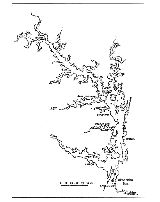
Fig. 3. LAKE VOLTA RESERVOIR
(Welcomme, 1972)
WEIJA RESERVOIR
| Geographical data | |
| Location: | Ghana - 5°35'N; 0°22'W |
| Altitude: | 14.1 m at USL |
| Date closed: | December 1974 |
| Surface area: | 33.61 km2 |
| Max. length: | 14 km |
| Max. width: | 2.2 km |
| Major inflowing river: Densu | |
| Outflowing river: | Densu |
ABY-TENDO-EHY LAGOON COMPLEX
(International water)
| Geographical data | |
| Location: | Côte d'Ivoire, Ghana - 5° 5'–23'N; 2° 51'-3° 21'W (Ghana has about 25 km of shoreline along the Tendo-Ehyportia but no actual lagoon surface area) |
| Surface area: | 410 km2 |
| Depth: | 14.9 m (max); 5.0 m (mean) |
| Max. length: | 52 km |
| Max. width: | 30 km |
| Annual fluctuation in level: 0.3–0.5 m | |
| Major inflowing rivers: Bia, Tano | |
| Outflow: | channel to Atlantic Ocean; also a short canal to Juen Lagoon in Ghana |
| Physical and chemical data: | |
| Surface temperature: 24–30° C | |
| Fisheries data | |
| No. of fishermen: | 1 654 (year unspecified) |
| No. of boats: | 617 (year unspecified) |
| Total annual catch: | 570 t (mean for 1968–71 period) |
AMANSURI LAGOON
| Geographical data | |
| Location: | Ghana - 5° 1'N; 2° 35'W |
AMISA LAGOON
| Geographical data | |
| Location: | Ghana - 5° 12'N; 1° 1'W |
| Major inflowing river: Ochi | |
| Outflow: | canal to Atlantic Ocean |
ANGAW LAGOON
| Geographical data | |
| Location: | Ghana - 5° 48'N; 0° 47'E |
| Major inflowing river: Volta | |
| Outflow: | canal to Atlantic Ocean |
AVU LAGOON
| Geographical data | |
| Location: | Ghana - 5° 59'N; 0° 45'E |
| Surface area: | 46 km2 |
| Max. length: | 11 km |
| Max. width: | 6 km |
| Major inflowing river: Todzie | |
| Outflow: | channels to Keta Lagoon |
BENYA LAGOON
| Geographical data | |
| Location: | Ghana - 5° 05'N; 1° 21'W |
BRENU LAGOON
| Geographical data | |
| Location: | Ghana - 5° 4'N; 1°26'W |
CHEMU LAGOON
| Geographical data | |
| Location: | Ghana |
| Special features: | heavily polluted |
ELMINA LAGOON
| Geographical data | |
| Location: | Ghana |
FOSU LAGOON
| Geographical data | |
| Location: | Ghana |
GAO LAGOON
| Geographical data | |
| Location: | Ghana |
JUEN LAGOON
| Geographical data | |
| Location: | Ghana - 5° 6'N; 2° 54'W |
| Outflow: | connected by a short canal to Aby-Tendo-Ehy Lagoon Complex in Côte d'Ivoire |
KETA LAGOON
| Geographical data | (see Fig. 4) |
| Location: | Ghana - 5° 55'N; 0° 56'W |
| Surface area: | 330 km2 |
| Max. length: | 29 km |
| Max. width: | 13 km |
| Major inflowing river: | outflow from Avu Lagoon |
| Outflow: | short channel to Atlantic Ocean |
| Catchment area: | 3 600 km2 |
| Physical and chemical data | |
| Surface temperature: | 27.7° C |
Fig. 4. THE KETA LAGOONS
(Weigel, 1985)
KORLE LAGOON
| Geographical data | |
| Location: | Ghana - 5° 32'N; 0° 13'W |
| Special features: | heavily polluted |
KPESHIE LAGOON
| Geographical data | |
| Location: | Ghana - 5° 33'N; 0° 10'W |
| Physical and chemical data | |
| Salinity: | to 72 ‰ |
LAIWI LAGOON
| Geographical data | |
| Location: | Ghana - 5° 42'N; 0° 4'E |
MUKWE LAGOON
| Geographical data | |
| Location: | Ghana -5° 36'N; 0° 3'W |
| Surface area: | 0.04 km2 |
| Depth: | 1.5 m (max) |
| Max. length: | 2 km |
| Physical and chemical data | |
| Surface temperature: | 24-8-32.2° C |
| Salinity: | 10–70 ‰ |
MUNI LAGOON
| Geographical data | |
| Location: | Ghana - 5° 20'N; 0° 39'W |
NAKWA LAGOON
| Geographical data | |
| Location: | Ghana - 5° 12'N; 0° 55'W |
OYIBI LAGOON
| Geographical data | |
| Location: | Ghana - 5° 22'N; 0° 36'W |
SAKUMO-ACCRA LAGOON
| Geographical data | |
| Location: | Ghana - 5° 32'N; 0° 17'W |
| Surface area: | 23.6 km2 |
| Max. length: | 5 km |
| Max. width: | 0.14 km |
| Major inflowing river: | Densu |
| Outflow: | canal to Atlantic Ocean |
| Physical and chemical data | |
| Salinity: | <1–36.3 ‰ |
SAKUMO-TEMA LAGOON
| Geographical data | |
| Location: | Ghana - 5° 37'N; 0° 2'W |
| Surface area: | 1 km2 |
| Depth: | 0.88 m (max); 0.50 (mean) |
| Max. length: | 4.42 km |
| Outflow: | canal to Atlantic Ocean |
| Physical and chemical data | |
| Surface temperature: | 18–34.3° C |
| Salinity: | <1–50.5 ‰ |
| Fisheries data | |
| No. of fishermen: | 13 in 1971 (no boats) |
| Total annual catch: | 15 t in 1971 |
SONGAW LAGOON
| Geographical data | |
| Location: | Ghana - 5° 49'N; 0° 28'E |
| Surface area: | 18 km2 |
| Max. length: | 20 km |
| Max. width: | 8 km |
| Major inflowing river: | Volta |
UNVAIYE LAGOON
| Geographical data | |
| Location: | Ghana |
| Surface area: | 11.1 km2 |
7. BIBLIOGRAPHY
Adumua-Bossman & Mensah, 1980
Allen & Gaudet, 1978
Balarin, 1988
Blanc & Daget, 1957
CSIR, 1986
Czernin-Chudenitz, 1971
Daget & Iltis, 1965
Denyoh, 1967; 1969; 1985
Entz, 1969; 1984
FAO, 1976; 1978a; 1981; 1982
FAO/IFAD, 1981
Fisheries Department, 1975
Government of Ghana, 1966
ICOUR, 1985
Mensah, 1979
Nerguaye-Tetteh et al., 1984
USAID, 1969
Vanderpuye, 1984
Weigel, 1985
Welcomme, 1972; 1979; 1985
World Bank, 1985
![]()
![]()
![]()