![]()
![]()
![]()
NASSER/NUBIA RESERVOIR
(International water)
(See detailed ref. in Entz, 1984)
| Geographical data (see Fig. 8) | ||
| Location: | Egypt (Nasser); Sudan (Nubia) - 20° 27'-23° 58'N; 30° 35'–33° 15'E | |
| Altitude: | 183 m at USL; 170–175 m mean | |
| Dam height: | 111 m | |
| Date closed: | May 1964; working lake level reached Sept. 1979 | |
| Surface area: | 6 850 km2 at USL | |
| 6 216 km2 at 180 m lake level (5 072 km2 in Egypt; 1 144 km2 in Sudan) | ||
| 3 057 km2 at 160 m lake level (2 497 km2 in Egypt; 560 km2 in Sudan) | ||
| Depth: | mean at 180 m lake level: | 25.2 m |
| at 160 m lake level: | 21.6 m | |
| max. at 180 m lake level: | 130 m | |
| at 160 m lake level: | 110 m | |
| Volume: | mean at 180 m lake level: | 65.9 km3 |
| (55.6 km3 in Egypt; 10.3 km3 in Sudan) | ||
| max. at 180 m lake level: | 156.9 km3 | |
| (132.4 km3 in Egypt; 24.5 km3 in Sudan) | ||
| Length: | max. at 180 m lake level: | 496 km |
| mean at 160 m lake level: | 430 km | |
| Width: | max. at 180 m lake level: | 60.0 km |
| mean at 180 m lake level: | 12.5 km (total lake) | |
| 18.5 km (only Nasser) | ||
| mean at 160 m lake level: | 7.5 km (total lake) | |
| 8.9 km (only Nasser) | ||
| Shoreline: | at 180 m lake level: | 9 250 km |
| at 160 m lake level: | 6 027 km | |
| Annual fluctuation in level: 7–10 m | ||
| Catchment area above High Dam: 2 400 000 km2 | ||
| Mean inflow: | 84.0 km3/yr; 2 662 m3/sec | |
| Suspended solids: | 1–10 mg/l (low water); 2–10 g/l (flood); inflow: 134 × 106 t/yr | |
| Displacement time: | 2 years | |
| Major inflowing river: | Nile | |
| Outflowing river: | Nile | |
Specific references: Ali, 1984; Entz, 1984; Latif, 1984; Marshall, 1984.
| Physical and chemical data | |||
| Surface temperature: | |||
| 16–32° C (23.9° C mean); 16–18° C during winter period | |||
| Conductivity: | 190–300 μS/cm; 260 μS/cm; (210–230 μS/cm mean) | ||
| Dissolved solids: | 175–200 mg/l (185 mean) | ||
| pH: | 6.8–9.0; 7.1–9.4 | ||
| Oxygen: | winter: 6.7–11 (surface); 5.4–8.7 (bottom) | ||
| summer: 4.9–10 (surface); 0 (bottom) | |||
| Ionic composition: | mg/l | ||
| Na | 8.2–27.8 | ||
| K | 1.9–8.0 | ||
| Ca | 14.3–27.5 | ||
| Mg | 4.5–12.5 | ||
| HCO3 | 70–160 | ||
| Cl | 2.96–9.83 | ||
| SO4 | 5–10.8 | ||
| SiO2 | 12.45–17.18 | ||
| NO3 | |||
| surf. | 0.001–1.25 | ||
| bottom | 0.04–1.27 | ||
| PO4-P | 0.10–0.17 | ||
| Fisheries data | |||
| No. of fish species: | |||
| In Nasser Reservoir: | |||
| 53 in 16 families (Latif, 1984). See list, Table 4 (p.186). Oreochromis niloticus and O. galilaea are the major fish landed, comprising 95% (1978) of the total fresh, and 75% (1978) of the total salted fish landed (Latif, 1984). | |||
| In Nubia Reservoir: | |||
| 43 in 16 families (Ali, 1984). See list, Table 4. | |||
Total annual catch and effort:
| Total catch (t) | No.of fishermen | No.of boats | ||
| Year | Nasser | Nubia | (Nasser only) | (Nasser only) |
| 1964 | 500 | |||
| 1966 | 749 | 600 | 200 | |
| 1967 | 1 415 | 1 050 | 350 | |
| 1968 | 2 663 | 1 500 | 500 | |
| 1969 | 4 071 | 1 815 | 599 | |
| 1970 | 5 618 | 198 | 2 466 | 816 |
| 1971 | 6 716 | 144 | 3 822 | 1 039 |
| 1972 | 8 545 | 228 | 4 540 | 1 135 |
| 1973 | 10 693 | 424 | - | - |
| 1974 | 12 257 | 268 | - | - |
| 1975 | 14 725 | 295 | - | - |
| 1976 | 15 971 | 285 | - | 2 000 |
| 1977 | 18 406 | 249 | - | - |
| 1978 | 22 587 | 204 | 5 964 | 1 962 |
| 1979 | 26 995 | 355 | - | - |
| 1980 | 30 316 | 628 | - | - |
| 1981 | 33 933 | 625 | - | - |
| 1982 | - | 9 000 | - | |
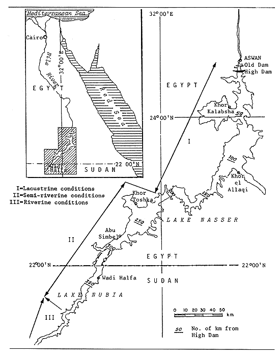
Fig. 8. NASSER/NUBIA RESERVOIR
(FAO/UNDP, 1975)
Potential annual yield:
Nasser Reservoir:
earlier estimates based on MEI: 19 000 t/yr
30 000 t/yr (Sadek, 1984)
35 000 t/yr in 1982 (Entz, 1984)
30 kg/ha/yr (Sadek, 1984)
78 kg/ha/yr (Entz, 1984)
Nubia Reservoir:
5 000 t/yr (Ali, 1984)
5 100 t/yr (51 kg/ha/yr) (Henderson, 1975)
Table 8. LIST OF FISH SPECIES FOR NASSER/NUBIA RESERVOIR
(adapted from Latif, 1984 and Ali, 1984)
| Family | Species | Nasser a | Nubia b | |
| 1. | PROTOPTERIDAE | Protopterus aethiopicus | + | + |
| 2. | POLYPTERIDAE | Polypterus bichir | + | |
| P. spp. | + | |||
| 3. | MORMYRIDAE | Mormyrops anguilloidos | + | + |
| Petrocephalus bane | + | + | ||
| Marcusenius isidori | + | |||
| M. spp. | + | |||
| Gnathonemus cyprinoides | + | + | ||
| Mormyrus kannume | + | + | ||
| M. caschive | + | + | ||
| Hyperopisus bebe | + | + | ||
| 4. | GYMNARCHIDAE | Gymnarchus niloticus | + | |
| 5. | CHARACIDAE | Hydrocynus forskalii | + | + |
| H. lineatus | + | |||
| H. brevis | + | |||
| Alestes nurse | + | + | ||
| A. baremose | + | + | ||
| A. dentex | + | + | ||
| 6. | DISTICHODONTIDAE | Distichodus niloticus | + | + |
| D. rostratus | + | |||
| D. engycephalus | + | |||
| 7. | CITHARINIDAE | Citharinus citharus | + | + |
| C. latus | + | |||
| 8. | CYPRINIDAE | Chelaethiops bibie | + | |
| Raiamas niloticus | + | |||
| R. loati | + | |||
| Labeo forskalii | + | |||
| L. niloticus | + | + | ||
| L. coubie | + | + | ||
| L. horie | + | + | ||
| Discognathus vinciguerrae | + | |||
| Barbus werneri | + | |||
| B. perince | + | |||
| B. neglectus | + | |||
| B. anema | + | |||
| B. bynni | + | |||
| 9. | CLARIDAE | Clarias anguillaris | + | + |
| C. Lazera | + | + | ||
| Heterobranchus bidorsalie | + | |||
| 10. | SCHILBEIDAE | Eutropius niloticus | + | + |
| Schilbe mystus | + | + | ||
| S. uranoscopus | + | |||
| Siluranodon auritus | + | |||
| 11. | BAGRIDAE | Bagrus bayad | + | + |
| B. docmac | + | + | ||
| Chrysichthys auratus | + | + | ||
| C. rueppelli | + | |||
| Clarotes laticeps | + | + | ||
| Auchenoglanis biscutatus | + | |||
| A. occidentalis | + | + | ||
| A. spp. | + | |||
| 12. | MOCHOKIDAE | Synodontis schall | + | + |
| S. serratus | + | + | ||
| S. clarias | + | |||
| S. batensoda | + | |||
| S. khartoumensis | + | |||
| Mochocus niloticus | + | |||
| Chiloglanis niloticus | + | |||
| 13. | MALAPTERURIDAE | Malapterurus electricus | + | + |
| 14. | CICHLIDAE | Oreochromis niloticus | + | + |
| O. galilaea | + | + | ||
| 15. | CENTROPOMIDAE | Lates niloticus | + | + |
| 16. | TETRODONTIDAE | Tetraodon fahaka | + | + |
| 17. | OSTEOGLOSSIDAE | Heterotis niloticus | + | |
| 53 | 43 |
a Latif, 1984
b Ali, 1984 (Note: Nubia data are for 1967–1979)
ROSEIRES RESERVOIR
| Geographical data (Welcomme, 1972, 1979) | |
| Location: | Sudan - 11° 40'N; 34° 23'E. See Figs. 2 and 6 (p.177). |
| Date closed: | 1966 |
| Surface area: | 290 km2 |
| Depth: | 68 m (max); 10 m (mean) |
| Volume: | 3 km3 |
| Max. length: | 75 km |
| Major inflowing rivers: | Blue Nile |
| Outflowing river: | Blue Nile |
| Annual fluctuation in water level: 13 m | |
| Fisheries data | |
| No. of fishermen: | 70–100 (1975) |
| Total annual catch: | |
| 300–500 t (1975) (Henderson, 1975); | |
| 2 250 t (1976), | |
| 1 800 t (1982), | |
| 1 500 t (1984) (George et al., 1985). | |
| Potential annual yield: | |
| 1 700 t (58 kg/ha/yr) (Henderson, 1975) | |
SENNAR RESERVOIR
| Geographical data (Welcomme, 1972, 1979; Henderson, 1975) | |
| Location: | Sudan - 13° 46'N; 33° 36'E. See Figs. 2 and 6 (p.177). |
| Altitude: | 422 m |
| Date closed: | 1925 |
| Surface area: | 140–160 km2 |
| Depth: | 26 m (max); 6.5 (mean) |
| Volume: | 0.93 × 10⁹ m3 (CSTR, 1982) |
| Major inflowing river: | Blue Nile |
| Outflowing river: | Blue Nile |
| Annual fluctuation in level: 17 m | |
| Fisheries data | |
| No. of boats: | 50 (1975) |
| Total annual catch: | |
| 1 000 t (1975) (Henderson, 1975) | |
| 1 400 t (1982), | |
| 1 100 t (1984) (George et al., 1985; FAO, 1982). | |
| Potential annual yield: | |
| 1 100 t (71 kg/ha/yr) (Henderson, 1975) | |
7. BIBLIOGRAPHY
Ali, 1984
Bailey, 1987
Balarin, 1986; 1988
Blache & Miton, 1962
Boulenger, 1907
Brook & Rzoska, 1954
Burgis, 1987
Carleton & Pena, 1982
Coche, 1983
CSTR, 1982
Dumont, 1984
Entz, 1984
Europa Publs., 1986
FAO, 1982; 1983a,b
FAO/UNDP, 1975
FAO/WB, 1976
George, 1975; 1976
George et al., 1985
Green, 1987
Hefny, 1982
Henderson, 1975
Huet, 1959
Ibrahim, 1984
Kapetsky & Petr, 1984
Krishnamurthy, 1981
Latif, 1984
Marshall, 1984
Osro, 1986
Sadek, 1984
Sandon, 1950
Talling, 1957
Welcomme, 1972; 1979; 1985
Yousif, 1985
1. GEOGRAPHY AND CLIMATE
Tunisia has an area of 15 536 km2. The Atlas Mountains dominate the topography of the northern part of the country, rising to a maximum elevation of 1 544 m asl. The south is mainly desert (40% of the total land area). The interior is hot and dry, while the coastal zone is more moderate. The north generally receives adequate rainfall. Due to low runoff and high salinities water quantity and quality limit irrigation agriculture in most parts of the country.
2. HYDROGRAPHY
2.1 Lakes
Kelbia (100 km2) and Sidi Mansour (35 km2) are the two largest low-salinity lakes. There are several others of less than 1.0 km2. A number of salt lakes and marshes occur in the country, some of large basin size (i.e., Chott Djerid, 4 580 km2; Chott Fedjadj, 570 km2; Sabkhet Sidi El Hani, 360 km2). The term “chott” or “sebkha” defines a non-permanent water body (swamp or lake), submitted to the occurrence of seasonal precipitations.
2.2 Rivers, Floodplains and Swamps
Four small river systems discharge into the Mediterranean Sea; the Oued Medjerda is the largest of these. Several landlocked rivers discharge into salt lakes. Total national runoff is only 2.5 km3/year of rainfall of 33 km3/year (90% is lost as evaporation).
2.3 Reservoirs
There are 14 large dams/reservoirs with a combined area of over 176 km2. The two largest are Bourguiba-Sidi Saad (90 km2) and Sidi Salem (43 km2). The total impounded volume is 1.451 km3 or 58% of total annual runoff. There are some 15 small earthen dams which store irrigation and potable water. Combined area is circa 2.0 km2. There are also small reservoirs associated with nine principal oases, with a combined area of 0.03 km2.
2.4 Coastal Lagoons
There are seven important coastal lagoons with a combined surface area of 550 km2; the largest are Bibane (230 km2), Bizerte (150 km2) and Ichekeul (100 km2).
2.5 Aquaculture
No data available on aquaculture ponds or production centres.
3. FISHERY PRODUCTION/POTENTIAL
3.1 Fish production and per caput supply (see Table 1)
3.2 Inland catch range and potential yield (see Table 2)
Table 1. FISH PRODUCTION - Tunisia, 1970–1987
| Nominal Production (including exports) (t) 2 | Nominal Consumer Supply (including exports) (kg/person) | ||||||||
| Year | Population '000 1 | Inland capture 7 | Aquaculture 3 | Marine capture 6 | Total | Inland capture | Aquaculture 3 | Marine capture | Total |
| 1970 | 5 127 | 100 | - 4 | 24 300 | 24 400 | 0.02 | - | 4.8 | 4.8 |
| 1971 | 5 220 | 100 | - | 27 400 | 27 500 | 0.02 | - | 5.3 | 5.3 |
| 1972 | 5 315 | 100 | - | 28 000 | 28 100 | 0.02 | - | 5.3 | 5.3 |
| 1973 | 5 412 | 800 | - | 31 000 | 31 800 | 0.15 | - | 5.7 | 5.7 |
| 1974 | 5 511 | 301 | - | 42 350 | 42 651 | 0.05 | - | 7.7 | 7.7 |
| 1975 | 5 611 | 0 | - | 31 686 | 31 686 | 0 | - | 5.6 | 5.6 |
| 1976 | 5 759 | 0 | - | 34 923 | 34 923 | 0 | - | 6.1 | 6.1 |
| 1977 | 5 911 | 0 | - | 38 441 | 38 441 | 0 | - | 6.5 | 6.5 |
| 1978 | 6 067 | 0 | - | 54 600 | 54 600 | 0 | - | 9.0 | 9.0 |
| 1979 | 6 228 | 0 | - | 58 778 | 58 778 | 0 | - | 9.4 | 9.4 |
| 1980 | 6 392 | 0 | - | 60 073 | 60 073 | 0 | - | 9.4 | 9.4 |
| 1981 | 6 524 | 0 | - | 57 376 | 57 376 | 0 | - | 8.8 | 8.8 |
| 1982 | 6 659 | 0 | 139 5 | 62 708 | 62 847 | 0 | 0.02 | 9.4 | 9.4 |
| 1983 | 6 797 | 0 | 186 5 | 67 051 | 67 237 | 0 | 0.03 | 9.9 | 9.9 |
| 1984 | 6 937 | 0 | 116 5 | 74 871 | 74 987 | 0 | 0.02 | 10.8 | 10.8 |
| 1985 | 7 081 | 0 | 147 5 | 88 908 | 89 055 | 0 | 0.02 | 12.6 | 12.6 |
| 1986 | 7 237 | 0 | 182 5 | 92 618 | 92 800 | 0 | 0.02 | 12.8 | 12.8 |
| 1987 | 7 396 | 0 | 212 5 | 99 169 | 99 381 | 0 | 0.03 | 13.4 | 13.4 |
1 Source: FAO
2 Source: FAO Fisheries Department FISHDAB
3 included in “Inland capture” if not specified.
4 - = data not available.
5 fresh, brackish and marine water (Vincke, 1989, pers.comm.).
6 from 1980 to 1983, marine exports were as follows: 1980–6 368 t; 1981–6 679 t; 1982–5 479 t; 1983–7 167 t. The export figure for 1969 was 1 555 t.
7 Lagoons capture is included in marine capture.
Table 2. INLAND CATCH RANGE
(no potential yield figures available)
| Water body | Period | Annual catch range (t) |
| Lake Besbessia | 1969 | 1.3 |
| Lake Kelbia | 1966; 1968; 1972 | 191.7; 18.5; 0.6 |
| Bir M'Chergua Reservoir | 1980 | 3.5 |
| Mellegue Reservoir | 1970; 1981 | 2.4; 4.4 |
| Nebhana Reservoir | 1980 | 8.9 |
| Bibane Lagoon | 1970; 1981 | 269; 440 |
| Bizerte Lagoon | 1973; 1981 | 24.5; 101 |
| Ghar El Melh Lagoon | 1967; 1981 | 21.4; 64 |
| Ichkeul Lagoon | 1970; 1981 | 60.6; 195 |
| Khenis Lagoon | 1971; 1981 | 7; 10.4 |
| Tunis Lagoon | 1970; 1981 | 472.8; 490.5 |
No information available for:
Lake Sidi Mansour; Mejerda River; Reservoirs Abdel Monam, Ben Metir,
Bezirk, Bou Heurtma, Bourguiba-Sidi Saad, Chiba, Gdir El Goulla,
Kasseb, Lakhmess, Masri, Mlaabi, Nacherine, Sidi Salem and Tahouna;
Bou Grara Lagoon
Total annual yield (including lagoons): 900–1 350 t
Potential annual yield: no data available.
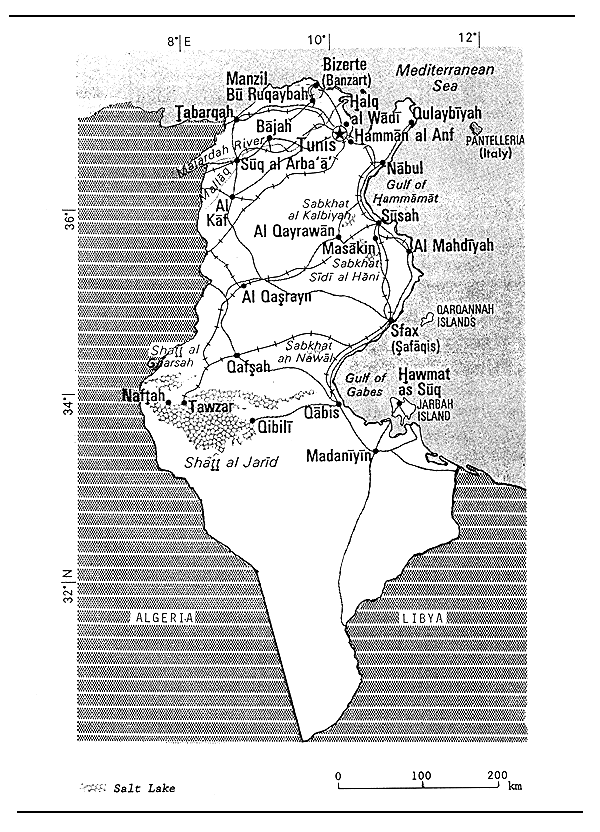
Fig. 1. MAP OF TUNISIA
4. STATE OF THE FISHERY
4.1 Yield
Since the mid-1950's total inland catch has generally remained between 900 and 1 500 t/yr. Most of this is derived from the lagoons. A significant production is obtained from aquaculture (finfish and shellfish). Aquaculture production (t) by species, from 1982 to 1987, is given below (Vincke, 1989, pers. comm.).
| Species | 1982 | 1983 | 1984 | 1985 | 1986 | 1987 |
| Dicentrarchus labrax | - | - | 2 | 15 | 30 | 40 |
| Sparus aurata | - | - | 15 | 5 | 20 | 25 |
| Mugilidae | - | - | - | 5 | 10 | 12 |
| Crassostrea gigas | 12 | 19 | 4 | 12 | 20 | 25 |
| Mytilus galloprovincialis | 127 | 167 | 95 | 110 | 102 | 110 |
| Total | 139 | 186 | 116 | 147 | 182 | 212 |
4.2 Factors influencing yield
Lakes and reservoirs suffer from prior rainfall runoff in some years (see, for example, the trend in catches from Lake Kelbia which is mainly the result of declining rainfall).
4.3 Future development possibilities
Certainly reservoir fisheries are at a low state of development and offer good possibilities for expansion. Lagoons also do not appear to be particularly heavily exploited. Extensive aquaculture practices could increase lagoon yields.
5. KEY BIBLIOGRAPHY
Lemoalle, 1987 (Coastal Lagoons)
6. WATER BODIES DIRECTORY
| Lakes (Chotts) | ||
| Besbessia | Kelbia | Sidi Mansour |
| Rivers | ||
| Medjerda | ||
| Reservoirs | ||
| Abdel Monam | Chiba | Mlaabi |
| Ben Metir | Gdir El Goulla | Nacherine |
| Bezirk | Kasseb | Nebhana |
| Bir M'Chergua | Lakhmess | Sidi Salem |
| Bou Heurtma | Masri | Tahouna |
| Bourguiba - Sidi Saad | Mellegue | |
| Lagoons | ||
| Bibane | Ichkeul (= Tindja) | |
| Bizerte (= Menzel, Abderahmen) | Khenis (= Monastir) | |
| Bou Grara | Tunis (= Goulette) | |
| Ghar El Melh | ||
LAKE BESBESSIA (Chott)
| Geographical data | |
| Location: | Tunisia |
| Fisheries data | |
| Total annual catch: | 1.3 t (1969) |
LAKE KELBIA (Chott)
| Geographical data | |||
| Location: | Tunisia - 35°35'N; 10°8'E (see Fig. 2 | ||
| Surface area: | 0–100 km2 (highly variable; can dry up) | ||
| Depth: | 2.25 m (max); 0.75 m (mean); 0 (min). | ||
| Physical and chemical data | |||
| Salinity: | highly variable: 1–80 ‰ | ||
| Dissolved solids: | 4.0–70 g/l | ||
| Fisheries data | |||
| Total annual catch: | |||
| Year | Total catch (t) | ||
| 1961 | 115.7 | ||
| 1966 | 191.7 | ||
| 1968 | 18.5 | ||
| 1969 | 82.1 | ||
| 1970 | 10.4 | ||
| 1971 | 41.8 | ||
| 1972 | 0.6 | ||
LAKE SIDI MANSOUR (Chott)
| Geographical data | |
| Location: | Tunisia - 34°14'N; 9°30'E |
| Surface area: | up to 35 km2, but can dry up completely for periods of several years. |
| Inflowing rivers: | Baiache, Segui, Belkhire |
| Physical and chemical data | |
| Temperature: | 3–24° C |
| Total dissolved solids: | 1 200 mg/l |
MEDJERDA RIVER
(International water)
| Geographical data | |
| Source: | Algeria |
| Total length: | 305 km (80 km in Algeria; 225 km in Tunisia) |
| Countries traversed: | Algeria, Tunisia |
| Major tributaries: | Mellegue |
| Discharges to: | Mediterranean Sea - 37°6'N; 10°14'E |
| Special features: | Mellegue Reservoir on Mellegue tributary in Tunisia |
ABDEL MONAM RESERVOIR
| Geographical data | |
| Location: | Tunisia |
| Surface area: | 0.31 km2 at normal level |
| Depth: | 3.5 m (mean) at normal level |
| Volume: | 1.1 × 10⁶ m3 at normal level |
| Outflowing river: | Abdel Monam |
| Physical and chemical data | |
| Total dissolved solids: 900 mg/l | |
BEN METIR RESERVOIR
| Geographical data | |
| Location: | Tunisia |
| Altitude: | 440 m at USL |
| Dam height: | 60 m |
| Date closed: | 1954 |
| Surface area: | 3.50 km2 at USL; 2.90 km2 at normal level |
| Depth: | 20.9 m (mean) at USL; 19.7 m (mean) at normal level |
| Volume: | 73 × 106 m3 at USL; 57.2 × 10⁶ m3 at normal level |
| Outflowing river: | El Lil |
| Physical and chemical data | |
| Total dissolved solids: | 1 000 mg/l |
BEZIRK RESERVOIR
| Geographical data | |
| Location: | Tunisia |
| Dam height: | 22 m |
| Date closed: | 1959 |
| Surface area: | 1.02 km2 at normal level |
| Depth: | 5.9 m at normal level |
| Volume: | 6 × 10⁶ m3 at normal level |
| Outflowing river: | Bezirk |
| Physical and chemical data | |
| Total dissolved solids: | 1 600 mg/l |
BIR M'CHERGUA RESERVOIR
| Geographical data | |
| Location: | Tunisia |
| Altitude: | 122.50 m at normal level |
| Dam height: | 43 m |
| Date closed: | 1971 |
| Surface area: | 7.05 km2 at normal level |
| Volume: | 0.130 m3 at USL |
| Outflowing river: | Meliane |
| Fisheries data | |
| Total annual catch: | 3.5 t (1980, 4 months) |
BOU HEURTMA RESERVOIR
| Geographical data | |
| Location: | Tunisia |
| Altitude: | 228 m at USL; 221 m at normal level |
| Date closed: | 1976 |
| Surface area: | 8.94 km2 at normal level |
| Depth: | 13.1 m (mean) at normal level |
| Volume: | 117.5 × 10⁶ m3 at normal level |
| Annual fluctuation in level: 2–3 m | |
| Major inflowing rivers: Guezala, El Lil | |
BOURGUIBA-SIDI SAAD RESERVOIR
| Geographical data | |
| Location: | Tunisia |
| Altitude: | 282 m at normal level |
| Date closed: | February 1982 |
| Surface area: | 90 km2 at normal level |
| Depth: | 40 m (max) at normal level; 2.2 m (mean) at normal level |
| Volume: | 0.200 m3 at normal level |
| Major inflowing rivers: | El Hateb, El Hadjed |
| Outflowing river: | Zeroud |
CHIBA RESERVOIR
| Geographical data | |
| Location: | Tunisia |
| Altitude: | 78 m at USL |
| Dam height: | 26 m |
| Date closed: | 1963 |
| Surface area: | 2.72 km2 at normal level |
| Depth: | 1.5 m (mean) at normal level |
| Volume: | 4 × 10⁶ m3 at normal level |
| Outflowing river: | Chiba |
| Physical and chemical data | |
| Total dissolved solids: | 1 500 mg/l |
GDIR EL GOULLA RESERVOIR
| Geographical data | |
| Location: | Tunisia |
| Dam height: | 27 m |
| Date closed: | 1968 |
| Surface area: | 0.07 km2 at normal level |
| Depth: | 40.0 m (mean) at normal level |
| Volume: | 2.8 × 10⁶ m3 at normal level |
KASSEB RESERVOIR
| Geographical data | |
| Location: | Tunisia |
| Altitude: | 292 m at USL |
| Dam height: | 57.6 m |
| Date closed: | 1969 |
| Surface area: | 4.37 km2 at USL |
| Depth: | 57 m (max) at USL; 18.7 m (mean) at USL |
| Volume: | 81.9 × 10⁶ m3 at USL |
| Annual fluctuation in level: 5 m | |
| Outflowing river: | Kasseb |
LAKHMESS RESERVOIR
| Geographical data | |
| Location: | Tunisia |
| Altitude: | 517 m at normal level |
| Dam height: | 32 m |
| Date closed: | 1966 |
| Surface area: | 1.02 km2 at normal level |
| Depth: | 7.8 m (mean) at normal level |
| Volume: | 14.6 × 10⁶ m3 at USL; 8.0 × 10⁶ m3 at normal level |
| Outflowing river: | Lakhmess |
MASRI RESERVOIR
| Geographical data | |
| Location: | Tunisia |
| Altitude: | 161 m at normal level |
| Dam height: | 38 m |
| Date closed: | 1965 |
| Surface area: | 0.95 km2 at normal level |
| Depth: | 7.4 m (mean) at normal level |
| Volume: | 7 × 10⁶ m3 at normal level |
MELLEGUE RESERVOIR
| Geographical data | |
| Location: | Tunisia - 36° 19'N; 8° 42'E |
| Altitude: | 270 m at USL (250 m, mean level) |
| Date closed: | 1956 |
| Surface area: | 16.0 km2 at USL |
| 14.72 km2 at normal level | |
| 7.705 km2 at mean level | |
| Depth: | 45 m max at mean level |
| 65 m max at USL | |
| 18.2 m (mean) at normal level | |
| Volume: | 267.7 × 10⁶ m3 at normal level |
| Outflowing river: | Mellegue |
| Physical and chemical data | |
| Total dissolved solids: | 1.0–2.5 g/l |
| Fisheries data | ||
| Total annual catch: | ||
| Year | Tons | |
| 1968 | 5.2 | |
| 1970 | 2.4 | |
| 1979 | 4.9 | |
| 1980 | 11.5 | |
| 1981 | 4.4 | |
MLAABI RESERVOIR
| Geographical data | |
| Location: | Tunisia |
| Surface area: | 0.98 km2 at normal level |
| Depth: | 3.6 m (mean) at normal level |
| Volume: | 3.5 × 10⁶ m3 at normal level |
| Outflowing river: | Mlaabi |
| Physical and chemical data | |
| Total dissolved solids: | 900 mg/l |
NACHERINE RESERVOIR
| Geographical data | |
| Location: | Tunisia |
| Dam height: | 14 m |
| Date closed: | 1962 |
| Surface area: | 0.151 km2 at normal level |
| Depth: | 9 m (max) at USL; 2.50 m (max) at mean level; |
| 2.6 m (mean) at normal level | |
| Volume: | 0.4 × 10⁶ m3 at normal level |
| Outflowing river: | Nacherine |
| Physical and chemical data | |
| Total dissolved solids: | 2 800 mg/l |
NEBHANA RESERVOIR
| Geographical data | |
| Location: | Tunisia |
| Altitude: | 230 m at USL |
| Dam height: | 62 m |
| Date closed: | 1968 |
| Surface area: | 5.32 km2 at USL |
| Depth: | 16.2 m (mean) at USL |
| Volume: | 86 × 106 m3 at USL |
| Outflowing river: | Nebhana |
| Physical and chemical data | |
| Temperature: | 12.8° C |
| Total dissolved solids: | 1 000 mg/l |
| Fisheries data | |
| Total annual catch: | 8.9 t (1980, 3 months) |
SIDI SALEM RESERVOIR
| Geographical data | |
| Location: | Tunisia |
| Altitude: | 110 m at USL |
| Dam height: | 57 m |
| Surface area: | 43.00 km2 at normal level |
| Depth: | 12.9 m (mean) at normal level |
| Volume: | 0.555 km3 at normal level |
| Outflowing river: | Mdjerda |
TAHOUNA RESERVOIR
| Geographical data | |
| Location: | Tunisia |
| Surface area: | 0.125 km2 at normal level |
| Depth: | 7.2 m (mean) at normal level |
| Volume: | 0.9 × 10⁶ m3 at normal level |
| Outflowing river: | Tahouna |
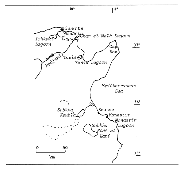
Fig. 2. COASTAL LAGOONS AND SEBKHAS OF NORTH TUNISIA
(after Lemoalle, 1987)
EL BIBANE LAGOON
(all data, except “Total annual catch, 1961–81” from Lemoalle, 1987)
| Geographical data | |
| Location: | Tunisia - 33° 15'N; 11° 15'E (see Fig. 3) |
| Surface area: | 230 km2 |
| Depth: | 6.8 m (max); 4 m (mean) |
| Volume: | 934 × 106 m3 |
| Physical and chemical data | |
| Surface temperature: | |
| max. August: 28–30°C | |
| min. January: 6–11 °C | |
| Salinity: | (in 1981–82, central part) |
| end of summer: 45 ‰; | |
| end of winter: 42 to 43.5 ‰ | |
| Alkalinity: | 2.5–2.8 meq/l |
| Ionic composition: | close to sea water |
| Fisheries data | |
| No. of fish species: | over 60 species, all marine; Sparus aurata, Diplodus annularis and Solea vulgaris = 60% of the catch. |
Total annual catch:
| Year | Tons | Year | Tons |
| 1961 | 628.4 | 1971 | 246.2 |
| 1962 | 583.0 | 1972 | 255.1 |
| 1963 | 652.4 | 1973 | 288.1 |
| 1964 | 596.2 | 1974 | 235.5 |
| 1965 | 513.8 | 1975 | 46.8 |
| 1966 | 478.2 | 1976 | 385.0 |
| 1967 | 448.5 | 1977 | 335.0 |
| 1968 | 385.9 | 1978 | 523.6 |
| 1969 | 256.4 | 1981 | 440.5 |
| 1970 | 269.6 | 1980's mean 535 t/yr (23 kg/ha) | |
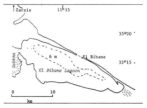
Fig. 3. EL BIBANE LAGOON
(after Lemoalle, 1987)
BIZERTE (= MENZEL, ABDERAHMEN) LAGOON
| Geographical data | |||
| Location: | Tunisia - 37° 12'N; 9° 51'E (see Fig. 2) | ||
| Surface area: | 150 km2 | ||
| Depth: | 15 m (max); 1.0 m (mean) | ||
| Max. length: | 13 km | ||
| Max. width: | 11 km | ||
| Major inflowing river: | Tindja Channel (outflow from Ichkeul Lagoon) | ||
| Outflow: | Bizerte Canal (8 km) to Mediterranean Sea. | ||
| Physical and chemical data | |||
| Surface temperature: | 10–28.6°C (18.25° C annual mean) | ||
| Salinity: | 27–39 ‰ (34.17 ‰ annual mean) | ||
| Fisheries data | |||
| Total annual catch: | Year | Tons | |
| 1908 | 170 | ||
| 1939 | 2 400 | ||
| 1973 | 24.5 | ||
| 1977 | 51 | ||
| 1981 | 101.6 | ||
| Aquaculture production: | (mussels) | ||
| 1964 | 92 | ||
| 1976 | 70 | ||
BOU GRARA LAGOON
| Geographical data | |
| Location: | Tunisia - 33° 35'N; 10° 50'E |
| Surface area: | 500 km2 (subdivided by a causeway into a large western basin and a small eastern basin) |
| Depth: | 10+ m (max); 3 m (mean) |
| Max. length: | 27 km |
| Max. width: | 22 km |
| Outflow: | restricted passageways to Mediterranean Sea. |
| Physical and chemical data | |
| Surface temperature: | 11.5–34° C |
| Salinity: | 37.50–39.35 ‰ |
GHAR EL MELH LAGOON
(all data, except “Total annual catch, 1961–81”, from Lemoalle, 1987)
| Geographical data | ||||
| Location: | Tunisia - 37° 10'N; 10°10'E (see Fig. 4) | |||
| Surface area: | 26 km2 | |||
| Total length: | 7 km | |||
| Max. width: | 4.5 km | |||
| Depth: | 2 m (max); 1.0 m (mean) | |||
| Major inflowing river: | ||||
| lateral flooding of Medjerda (formerly); at present several small streams and drainage channels. | ||||
| Outflow: | short canal to Mediterranean Sea. | |||
| Physical and chemical data | ||||
| Salinity: | in winter: 25–37 ‰ | |||
| in summer: 39–46 ‰ | ||||
| Surface temperature: | 18.5°C (mean); 27.4°C (max); 9.7°C (min). | |||
| Ionic composition: | same as sea water. | |||
| Fisheries data | ||||
| No. of fish species: | 12 small stationary species; | |||
| 32 migratory marine species. | ||||
| No. of fishermen: | 420 | |||
| Total annual catch: | ||||
| Year | Tons | Year | Tons | |
| 1961 | 57.7 | 1971 | 16.0 | |
| 1962 | 119.0 | 1972 | 11.3 | |
| 1963 | 162.6 | 1973 | 63.5 | |
| 1967 | 21.4 | 1974 | 50.2 | |
| 1968 | 21.5 | 1975 | 46.9 | |
| 1969 | 20.2 | 1976 | 44.8 | |
| 1970 | 15.3 | 1978 | 64.8 | |
| 1981 | 64.1 | |||
| 1980'5, current mean: 62 ± 20 t/yr | ||||
| (Mugils over 50%; Anguilla, 15%; Dicentrarchus, 8%) | ||||
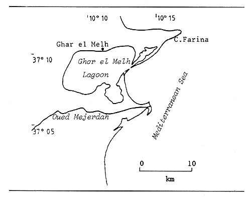
Fig. 4. GHAR EL MELH LAGOON
(Lemoalle, 1987)
ICHKEUL (= TINDJA) LAGOON
(all data, except “Total annual catch, 1961–81” from Lemoalle, 1987)
| Geographical data | ||||
| Location: | Tunisia - 37° 17'N; 9° 40'E (see Fig. 2) | |||
| Surface area: | 89 km2 in summer; 100 km2 in winter | |||
| Catchment area: | 2 200 km2 | |||
| Total length: | 14 km | |||
| Max. width: | 5 to 6 km; plus swamp extensions in winter | |||
| Depth: | 2 m (max); 0.90 m (mean) | |||
| Major inflowing rivers: | Sejnane (44%) and Joumine (38%); total inflow, including smaller streams: 271 × 106 m3/yr. In summer, sea water inflow through Tindja Channel. | |||
| Outflow: | Tindja Channel to Bizerte Lagoon (5 km downstream) in winter. | |||
| Physical and chemical data | ||||
| Surface temperature: | 9.5–29.5° C (18.2° C annual mean) | |||
| Salinity: | 1–3 ‰ (end winter); 30–33 ‰ (end summer) | |||
| Fisheries data | ||||
| No. of fish species: | mainly Mugils (68% of the catch), Anguilla (25%), Dicentrarchus labrax and Solea vulgaris | |||
| Total annual catch: | ||||
| Year | Tons | Year | Tons | |
| 1961 | 19.3 | 1971 | 92.1 | |
| 1962 | 72.2 | 1972 | 92.8 | |
| 1963 | 129.8 | 1973 | 260.5 | |
| 1964 | 60.4 | 1974 | 173.0 | |
| 1965 | 86.4 | 1975 | 160.6 | |
| 1966 | 127.6 | 1976 | 115.7 | |
| 1967 | 57.6 | 1977 | 123.1 | |
| 1968 | 76.7 | 1978 | 132.0 | |
| 1969 | 22.2 | 1981 | 195.0 | |
| 1970 | 60.6 | |||
| 1980's, current mean: 128 t/yr (13.5 kg/ha) with high variability. | ||||
KHENIS (= MONASTIR) LAGOON
(all data, except “Total annual catch, 1961–81” from Lemoalle, 1987)
| Geographical data | |||
| Location: | Tunisia - 35° 45'N; 10° 45'E (see Fig. 5) | ||
| Surface area: | 1.73 km2 | ||
| Total length: | 3 km | ||
| Max. width: | 0.5 km | ||
| Depth: | 2.00 m (max. in the channel); 0.5 m (mean central) | ||
| Special features: | an artificial lagoon created by damming shallow seabed in the South (in 1952). | ||
| Physical and chemical data | |||
| Surface temperature: | mean, in 1977–78: 12.8°C in January; 28°C in July | ||
| Salinity: | 40 to 50 ‰ | ||
| Oxygen (saturation): | 60 to 130% | ||
| Fisheries data | |||
| No. of fish species: main catches: mugils, Sparidae | |||
| Total annual catch: | |||
| Year | Tons | ||
| 1971 | 7.0 | ||
| 1972 | 4.4 | ||
| 1973 | 16.0 | ||
| 1974 | 5.4 | ||
| 1975 | 11.2 | ||
| 1976 | 11.9 | ||
| 1977 | 9.4 | ||
| 1978 | 9.2 | ||
| 1981 | 10.4 | ||
| Production: | mean: 34 kg/ha/yr; since 1984 there is an important aquaculture production centre. | ||
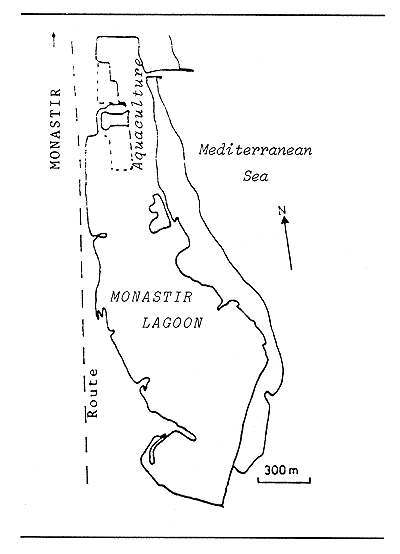
Fig. 5. MONASTIR LAGOON
(after Lemoalle, 1987)
TUNIS (= GOULETTE) LAGOON
(all data, except “Total annual catch, 1961–81” from Lemoalle, 1987)
| Geographical data | |||
| Location: | Tunisia - 36° 50'N; 10° 10'E (see Fig. 6) | ||
| Surface area: | 45 km2 (bisected by a canal), decreasing | ||
| North basin: 28 km2; outflow: Khereddine Channel | |||
| South basin: 13 km2; outflow: South Channel | |||
| Depth: | 3.60 m (max); l m (mean) | ||
| Physical and chemical data | |||
| Surface temperature: | |||
| 19.2°C (mean); 9°C (in winter); 30°C (in August) | |||
| Salinity: | North basin: 38 ‰ (winter 33, summer 43 ‰) | ||
| South basin: 42 ‰ (winter 40, summer 45 ‰) | |||
| Special features: | highly eutrophic due to input of municipal sewage; high concentration of H2S in sediments, mainly in north basin. | ||
| Fisheries data | |||
| Main fish species: | Mugilidae (mainly Mugil cephalus, chelon labrosus, Liza ramada) and Anguilla anguilla, for the migratory species; Aphanius fasciatus as stationary species. | ||
| Total annual catch: | |||
| Year | Tons | ||
| 1961 | 496.6 | ||
| 1962 | 582.0 | ||
| 1963 | 357.2 | ||
| 1964 | 364.2 | ||
| 1965 | 313.0 | ||
| 1966 | 408.7 | ||
| 1967 | 535.6 | ||
| 1968 | 432.6 | ||
| 1969 | 606.9 | ||
| 1970 | 472.8 | ||
| 1971 | 546.7 | ||
| 1972 | 531.3 | ||
| 1973 | 946.7 | ||
| 1974 | 651.1 | ||
| 1975 | 465.7 | ||
| 1976 | 379.7 | ||
| 1977 | 580.5 | ||
| 1978 | 700.0 | ||
| 1981 | 490.5 | ||
| 1980's, current mean: 500 t | |||
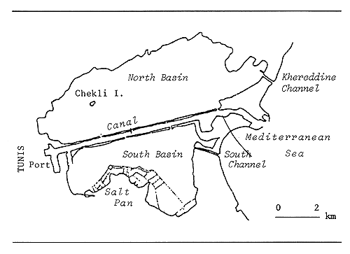
Fig. 6. TUNIS LAGOON
(after Zaouali, 1987)
7. BIBLIOGRAPHY
Lemoalle, 1987
Zaouali, 1987
1. GEOGRAPHY AND CLIMATE
The Saharawi (surface area of 178 999 km2) consists largely of desert plateau. The climate is hot and semi-arid. Most of the country is too arid for agriculture. There are large deposits of phosphate.
2. HYDROGRAPHY
2.1 Lakes
Although there are a number of lake basins, they are usually dry.
2.2 Rivers, Floodplains and Swamps
There are two river systems (the Uad el Fat and Uad Assag), but they infrequently contain water.
2.3 Reservoirs: None of significant size.
2.4 Coastal Lagoons: None of significant size.
2.5 Aquaculture: No aquaculture in West Sahara (Vincke, 1989, pers.comm.)
3. FISHERY PRODUCTION/POTENTIAL
3.1 Fish production and per caput supply (see Table 1)
3.2 Inland catch range and potential yield
No information available.
4. STATE OF THE FISHERY
4.1 Yield
No data available, but there seems to be no inland fishery activity.
4.2 Factors influencing yield
Extremely low rainfall.
4.3 Future development possibilities
Extremely limited. The construction of artificial coastal lagoons (for example at Bahia, de Rio de Oro) would create some additional potential.
5. KEY BIBLIOGRAPHY (none)
Table 1. FISH PRODUCTION AND PER CAPUT SUPPLY - West Sahara, 1970–1987
| Nominal Production (including exports) (t) 2 | Nominal Consumer Supply (including exports) (kg/person) | ||||||||
| Year | Population '000 1 | Inland capture | Aquaculture 3 | Marine capture | Total | Inland capture | No aquaculture | Marine capture 5 | Total |
| 1970 | 76 | - 4 | 4 000 | 4 000 | - | 52.6 | 52.6 | ||
| 1971 | 84 | - | 4 000 | 4 000 | - | 47.6 | 47.6 | ||
| 1972 | 93 | - | 4 000 | 4 000 | - | 43.0 | 43.0 | ||
| 1973 | 102 | - | 4 000 | 4 000 | - | 39.2 | 39.2 | ||
| 1974 | 110 | - | 4 000 | 4 000 | - | 36.4 | 36.4 | ||
| 1975 | 117 | - | 4 000 | 4 000 | - | 34.2 | 34.2 | ||
| 1976 | 123 | - | 4 000 | 4 000 | - | 32.5 | 32.5 | ||
| 1977 | 126 | - | 4 000 | 4 000 | - | 31.7 | 31.7 | ||
| 1978 | 129 | - | 4 000 | 4 000 | - | 31.0 | 31.0 | ||
| 1979 | 132 | 0 | 0 | 0 | 0 | 0 | 0 | ||
| 1980 | 135 | 0 | 0 | 0 | 0 | 0 | 0 | ||
| 1981 | 139 | 0 | 0 | 0 | 0 | 0 | 0 | ||
| 1982 | 142 | 0 | 0 | 0 | 0 | 0 | 0 | ||
| 1983 | 147 | 0 | 0 | 0 | 0 | 0 | 0 | ||
| 1984 | 151 | 0 | 0 | 0 | 0 | 0 | 0 | ||
| 1985 | 155 | 0 | 0 | 0 | 0 | 0 | 0 | ||
| 1986 | 159 | 0 | 0 | 0 | 0 | 0 | 0 | ||
| 1987 | 164 | 0 | 0 | 0 | 0 | 0 | 0 | ||
1 Source: FAO
2 Source: FAO Fisheries Department FISHDAB
3 No aquaculture in West Sahara (Vincke, 1989, pers.comm.)
4 - = data not available.
5 Most of the fish being exported, the “nominal consumer supply” data for marine capture do not reflect the reality and are highly overestimated.
6. WATER BODIES DIRECTORY
No permanent water body.
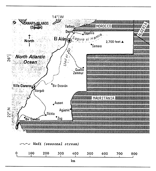
Fig. 1. MAP OF WEST SAHARA
![]()
![]()
![]()