![]()
![]()
![]()
by R.K. Shrestha
PHYSICAL ENVIRONMENTAL CONDITION
Location of the Area
The mid-hill region is a major portion of Nepal and accounts for 43% of the total land area. The region is considered the original heartland of Nepal, and includes some of the most beautiful and fertile valleys in the country - Kathmandu, Pokhara, Banepa, and Trisuli, along with a rugged mountain topography. It is centrally located extending from the southern slopes of the main Himalayan ranges to the Mahabharat ranges, with a varying width of 60 to 110 km running across the length of the country. The location of the region is approximately 26°85" - 29°85"N and 80°04 - 88°12"E, with an altitudinal range between 500m and 3000m.
Topography and Geography
The mid-hill zone is of generally rugged mountain topography, so the altitude can vary considerably within a short horizontal distance. Thus, the mid-hills include deep river valleys well below 1000m, while the nearby ridge tops may rise to more than 3000m. Accordingly, climate and the vegetation show great variation over a very short distance, and give rise to great ecological diversity and complexity. In general, the area rises towards the north, to the main Himalayan ranges, and up to 30% of these slopes are worked traditionally into innumerable terraces, which are extensively cultivated. This is the only arable land available in the region, apart from some highly productive valleys such as those around Kathmandu, Pokhara and Banepa.
The great rivers of Nepal - the Karnali, the Gandaki and the Koshi which originate from the Tibetan plateau have deeply incised the area, and their many tributaries flow through deep gorges between massive mountains. The significant discharge of these rivers even during the dry period of the year, has made them very important to the country. The water of these rivers is one of the major natural resources for hydropower, supply of which has been theoretically estimated at 83,000mw, out of which 27,000mw is considered to be economically feasible. They also have a potential for irrigation programmes. There are many other medium sized rivers such as the Bagmati, Kali, Kamala, Trishuli, Rapti, Kankai and Mechi, which flow out of the Mahabharat range, and are fed by ground water springs and seasonal rainfall. All are perennial, but are characterised by large seasonal fluctuations in discharge, which can cause great damage to their banks every year. Apart from these, many streams rise on the slopes of the mid-hills which flow north-south, but which are frequently seasonal. The erratic discharge of these smaller rivers during the monsoon can also cause much damage by cutting their banks, but at the same time they are invaluable for irrigating the main arable crop of paddy rice.
Geology
Geologically, the structure of the area is complex, with hills and ridges which are composed of hard rocks, and major valleys with deposits along rivers and streams. A large portion of the southern Himalayan slopes, and the Mahabharat ranges are composed of alternative strata of shale, schist, quartzite and phyllite, together with beds of limestone, and other rocks of granite and gneiss. These are the oldest rock of the pre-Cambrian era found in Nepal. Sedimentary sandstones and lime stones of the Cambrian to Devonian ages have overlain some of the high peaks of the Mahabharat range. The presence of strong folds, and faults in the geological formations, render the region very vulnerable to natural surface erosion, landslides and slips.
It has been estimated that 50% to 70% of the landslides in the region are solely of geological origin (Laban, 1979). These are aggravated both by the extensive annual rainfall which occurs over a very short period of time, and the deterioration of the forest cover. Also, the mountains of the region are geologically young and are still rising, because of the northward thrust of the Indian tectonic plates, and consequently earthquakes also give rise to additional landslides and erosion.
Soil
The nature of the soil is very dependant upon the nature of the parent material from which it is derived. Accordingly, because of the different types of parent material and microclimate, the soil type in Nepal can vary widely within a very short distance. The major portion of the mid-hill soil is formed from the phyllitic schists and gneisses, with some limestones and carbonaceous material. Alluvial deposits occupy the valley bottoms, with some recent coarse deposits. A detailed soil map of the region is not available, but the Land Resource Mapping Project (LRMP, 1986) has produced a general soil map of the country. There is an urgent need for detailed maps of the mid-hill region to assist with better land-use planning.
The classification used by the LRMP is based upon the United States Department of Agricultural System (Soil Survey Staff USDA, 1975). According to this classification the following types of soil are found in the mid-hills.
Entisoils: This type of soil is commonly found from the mid-hills to the high moutain areas. The soil is very young, with very thin layers of horizons O, A and B. The bulk of the soil is made up of unchanged parent material such as sand or rock fragments. This soil is of low fertility and susceptible to erosion unless well terraced for agriculture. Areas with this type of soil are not suitable for arable agriculture, but are acceptable for forestry and pasture development.
Inceptisoils: Common in the mid-hills, and though more developed than the entisoils, these are still young in nature. Here, the A horizon consists of less clay than the B Horizon, and has a high pH value. The B horizon is brown to grey in colour, with a dominance of coarse-grained sand and gravel of high permeability. The top horizon is prone to sheet erosion. Organic matter, nitrogen, phosphorus and potassium content varies from low to medium. The lower valley portions of the region have thick organic deposits with a good fertility regime. This type of soil is suitable for arable crop cultivation.
Mollisoils: This type of soil is common in the lower hills and valleys, and is generally a rich, dark coloured soil, found in moist conditions. All horizons have a thick soil layer of alluvial origin, with fine texture and a high pH value in the A horizon. This soil is less susceptible to erosion.
Alfisoils: Found throughout the Churia and lower portion of mid-hills. This is a well developed soil where horizons A and B are distinct in colour. However, the soil is acidic in nature and has a dark coloured B horizon with a layer of clay. The soil is unable to retain water associated with high rainfall and is prone to erosion. Additionally, the texture is sandy to sandy-loam with variable drainage.
Although most studies are based upon these classifications, it should be borne in mind that the people themselves have a highly developed indigenous soil classification system, based upon the traditional knowledge of the region. Soil colour and texture are two dominant criteria considered by farmers for soil classification (Tamang, 1991). Soil is usually classified by colour, as being red (rato mato), black (kalo mato) etc., and within each colour group, various textures are defined such as chimtay (clay), balautay (sandy) etc. Different management practices are then adopted for different soil types. More study is required to fully evaluate the existing indigenous knowledge.
Climate
The climate of the region is very complex, because of the extreme differences in elevation. Topography, aspect and the location of the area, also have a substantial effect upon the local climate. Therefore, within short distances climates from sub-tropical to cold temperate can be experienced. These zones can be further modified by rain shadows, as in the leeward side of the High Himalaya mountain ranges.
The country is in the monsoon climate zone, and the weather regime of the region is directly influenced by the summer monsoon rains which have been recorded in excess of 5000mm in some places. More than 80% of the annual total rainfall is the summer monsoon, which occurs generally between June and September, and occasionally until October. The monsoon starts one to two weeks earlier in the east of the country than in the west. There is also some pre-monsoon, post-monsoon and winter rain, this last being very critical for winter crop production. The region receives a wide range of rainfall, due to the large mountain ranges, altitude and aspect. The southern side of the Himalayas and the northern parts of the Mahabharat range receive heavy rainfall (over 5000mm per annum at Lumle) in total contrast to areas to the north of the Himalayas where rainfall can be as little as 250 to 350mm per year. Rainfall in the southern part of Mahabharat varies from 1600 to 2500mm.
Besides the heavy rainfall, many parts of the region experience severe hail storms during the pre-monsoon period, which can cause major damage to both crops and trees, particularly as they invariably occur just prior to the harvest of arable crops.
Temperatures over the country are affected both by season, altitudinal variation and aspect. South-facing slopes are hotter and drier than those which face North. The mean temperature decreases by 5.5°C for every 1000m rise in altitude (Goldsmith, 1981), and minimum temperature falls below freezing point in the winter on the upper ridges (over 3500m), where snowfall is also common. The permanent snowline in the country is at around 5000m. High wind velocities of short duration are also common during the pre-monsoon period, and can cause severe local damage. Data for maximum and minimum temperatures according to season and altitude are given in Table 1.
Table 1: Monthly mean daily temperatures (°C) for selected elevations in Nepal.
| Month | Elevation | |||
| 1000m | 2000m | 3000m | ||
| January | max | 18.3 | 13.0 | 7.8 |
| min | 6.1 | 1.8 | -4.5 | |
| February | max | 20.4 | 14.5 | 8.6 |
| min | 7.5 | 3.1 | -2.2 | |
| March | max | 25.2 | 18.2 | 11.2 |
| min | 11.4 | 6.6 | 1.8 | |
| April | max | 28.7 | 21.8 | 14.9 |
| min | 16.1 | 10.1 | 4.1 | |
| May | max | 29.8 | 23.2 | 16.6 |
| min | 18.5 | 12.4 | 6.4 | |
| June | max | 29.1 | 23.6 | 18.1 |
| min | 20.3 | 15.1 | 9.8 | |
| July | max | 27.8 | 23.1 | 18.3 |
| min | 20.7 | 15.8 | 10.9 | |
| August | max | 28.1 | 23.3 | 18.5 |
| min | 20.5 | 15.5 | 10.5 | |
| September | max | 27.8 | 22.9 | 18.1 |
| min | 19.3 | 14.2 | 9.2 | |
| October | max | 26.1 | 20.6 | 15.1 |
| min | 15.9 | 10.3 | 4.1 | |
| November | max | 23.0 | 17.2 | 11.4 |
| min | 10.6 | 6.0 | 1.4 | |
| December | max | 19.5 | 14.3 | 9.1 |
| min | 6.8 | 3.0 | 1.6 | |
Source: LRMP (1986)
NATURAL VEGETATION
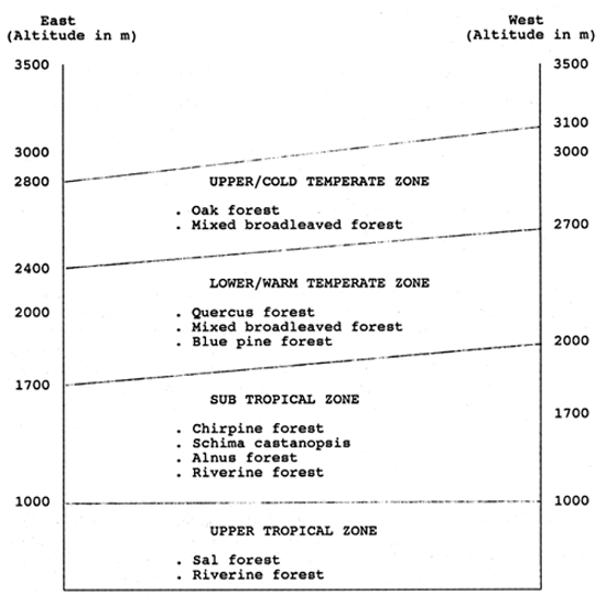
Over 40% of the country's remaining forest resources are in the mid-hill region. Climate, rainfall, temperature, altitude and human activities exert a great influence on the natural vegetation. For this publication, the natural vegetation zones have been classified primarily on the system adopted by Jackson (1987), based upon altitude, but this itself was a modification of those defined by Dobremez (1976, cited by Jackson, 1987) and Shrestha (1982). The main zones identified are described below.
UPPER TROPICAL ZONE: Up to 1000m
Sal forest: Sal (Shorea robusta) with its common associates - Terminalia spp, Anogeissus spp, Lagerstroemia and Syzygium spp.
Riverine forest: Along the river banks and alluvial deposits - Khair (Acacia catechu) and Sisso (Dalbergia sissoo), replace Sal with main associates of Bombax ceiba, Syzygium spp., and Michelia champaca.
Sub-tropical zone: Approximately 1000 to 2000m in the western regions, and 1000 to 1700m in the eastern regions.
Chir pine forest: Chir pine (Pinus roxburghii) with some Schima wallichi and Castanopsis indica and scattered Sal in the lower parts.
Schima - Castanopsis forest: Mainly Schima wallichii, Castanopsis spp. with some Daphniphyllum himalense. Once this forest covered a large portion of the region, but has been reduced through clearing and cultivation.
Alnus forest: Pure Alnus nepalensis colonises new soil (eg. landslips) with scattered Lyonia ovalifolia in places.
Riverine forest: Evergreen-type confined to narrow strips along the rivers/streams with Toona ciliata and Albizia spp.
Warm temperate zone: From 2000 to 2700m in the West and 1700 to 2200m in the East.
Quercus Forest: characterised by different oaks (Quercus spp). with Aesculus and Acer spp.
Mixed Broad-leaved Forest: Mainly Lauraceae family with Machilus, Neolitsea and Michelia spp.
Blue Pine Forest: Pure small patches of Pinus wallichiana.
Cold temperate zone: From 2700 to 3100m in the West and 2400 to 2800m in the East.
Oak Forest: Pure Quercus semicarpifolia with Rhododendron spp. and Ilex spp. as under storey.
Mixed Broad-leaved Forest: Mainly Acer and Rhododendron spp. with occasional small patches of Tusga dumosa.
Figure 1 gives the vegetation types of the region according to altitude and East-West direction.
SOCIO-ENVIRONMENTAL CONDITIONS
Population
According to the recently completed 1991 census, the population of the country is 18.4 million, 45.6% of which resides in the mid-hill regions, with an annual growth rate of 2.1% (Gorkha Patra, 1991) as against 2.6% from the 1981 census (see Table 2).
Figure 1: Vegetation zones from the East to West in the mid-hills by altitude.
Population growth trends between 1971 and 1991 clearly indicate that the distribution of the population has changed, with increases in the Terai, and decreases in the hills and mountains. This is the result of outward migration from the Hill Districts to the Terai, in response to the greater economic opportunities there. In spite of this, there has still been no overall reduction in the population of the hill regions either. The rural population density per unit area of arable land is over 1500/km2, or 15 per hectare, and this overpopulation has a detrimental effect upon the available resources. Crop production is declining, and between 1970 and 1980, cereal grain production of the mid-hills fell by 6.7%, largely as a result of a decline in soil fertility (Karki, 1984). This trend of decreasing yields of grain continues, in spite of all efforts given to agricultural development. This has forced the people to encroach into the remaining forest areas, which are steep and inherently unsuitable for agricultural development. The result has been an increase in land slides and erosion in many places.
Table 2: Changes of population in Nepal based upon data from the 1971, 1981 and 1991 National Census Statistics.
| Year/Region | 1971 | 1981 | 1991 | |||
| Million | % | Million | % | Million | % | |
| High Himal | 1.1 | 9.8 | 1.3 | 8.7 | 1.4 | 7.8 |
| Mid-hills | 6.1 | 52.3 | 7.2 | 47.8 | 8.4 | 45.5 |
| Terai | 4.3 | 38.0 | 6.6 | 43.6 | 8.6 | 46.6 |
Source: CBS (1986); Gorkha Patra (1991)
Concentrated settlements of the ancient Nepalese tribes are generally confined to those areas with good access to fuelwood, fodder, and water. Although there are no clear historical criteria or reasons for settlement in a particular area, compact hamlets with a few dwellings are found to be scattered widely over the region connected by footpaths and trails. Over 90% of the population derive their livelihood from agriculture, and 80% of the farmers in the region are classified as subsistence farmers. Over 90% of the population is Hindu, but there are also Buddhist, Islamic and Christian believers. The infant mortality rate of the region is high at 133 per 1000 live births.
LAND USE
Within the region there is great diversity of land use due to topography, climate, population, aspect and geological formation. In general, the steep slopes and dry parts of the region are left as forest, grassland or rough/pasture land (kharbari), while the areas with gentle slopes and reliable rainfall are extensively cultivated. Slopes up to 30% are traditionally formed into innumerable terraces for growing crops. A summary of land use type within the region is given in Table 3.
Nepal has a total of 2.97 million hectares of cultivated land of which 27.5% is situated in the mid-hills, and so is highly influenced by the diverse geo-climatic conditions. It is generally accepted that no more land is available for development for arable cropping in the hill regions. However, people are still actively involved in swidden agriculture, moving onto steep slopes and cultivating without constructing proper terraces. This has created major hazards and disasters, such as soil erosion, landslides and loss of crop land and production. In this way, the ecosystem is being continually degraded, and numerous forest species and agricultural crops are under threat. Although over 40% of the total area is under forest, much is in a very poor condition, the exceptions being those parts which are inaccessible to the local population by virtue of topography. Scrub and grassland now occupy around 9% and 7% of the area in the region respectively. These grass and scrublands give very low levels of production, both because of overstocking with livestock, and lack of proper management. As a result, these degraded lands are losing their original flora, which are being replaced by unpalatable and useless species such as Eupatorium spp. However, it is possible to reclaim these areas and make them more productive, by placing them under protection, and developing simple management plans, so that they can continue to support the community by supplying both surplus fodder for livestock and fuelwood.
Table 3: Land use categories of the mid-hills of Nepal.
| Category | Nepal | Mid-hills | ||
| '000 ha. | % | '000 ha. | % | |
| Forest land | 5616 | 38.1 | 1794 | 40.4 |
| Grassland | 1757 | 11.9 | 293 | 6.6 |
| Scrubland | 690 | 4.7 | 409 | 9.2 |
| Cultivated land | 2968 | 20.1 | 1223 | 27.5 |
| Non-cultivated inclusions | 987 | 6.7 | 665 | 15.0 |
| Other land (ice) rock, urban and water. | 2730 | 18.5 | 61 | 1.4 |
| Total | 14748 | 4445 | ||
Source: LRMP (1986)
FARMING SYSTEM
The traditional farming practices of the region have evolved into a complex system where livestock husbandry, forestry and arable cropping are practised together, and any changes in one component will exert a significant effect upon the others (Mahat, 1985). The difficult topography, and the great climatic variation, means that the whole farming system is extremely labour intensive.
As stated above, over 90% of the population derives its livelihood from agricultural production, and the contribution of agriculture to the total gross national product (GNP) was 56% in 1985 (CBS, 1985). Of this, livestock accounted for 28% (Table 4).
Table 4: Contribution of agriculture to the GNP of Nepal 1984/85.
| Sector | Percentage |
| - Agricultural | 56 |
| - Non-agricultural | 44 |
| Agricultural Sub-sector | |
| - Arable cropping | 56 |
| - Livestock | 28 |
| - Forest | 11 |
| - Other | 5 |
Source: CBS (1985)
Two distinct land types exist, distinguished by either being irrigated or rainfed. The rainfed bari/pakho is cultivated unbunded upland, on sloping terraces, and on unirrigated valley bottoms. The second is khetland, usually distributed along the river/stream banks, and which is bunded for flooding, under various irrigation systems. Khetland is usually highly productive, and has a better cropping potential compared to bariland. However in total area, bariland far exceeds khetland, and so the latter is much more valued in the regions where it is available. Where small-scale irrigation schemes can be introduced, farmers invariably convert bariland into khetland at lower altitudes.
The most important cropping practices are maize-based on the non-irrigated bariland, and rice-based on irrigated khetland. Although rice and maize are the two major staple crops of the region, wheat, millet, barley, potato, mustard and some other minor crops also make important contributions to hill agriculture. Rice can be grown virtually everywhere below 1800m on irrigated land, and maize on rainfed land up to an altitude of 2500m.
Following the main season rice crop, khetland is generally left fallow in the winter, but in areas where there is irrigation, wheat may be grown. Most commonly, soyabean (Glycine max) and blackgram (Vigna mungo) are grown on the bunds of khetland in the summer but gram, lentil (Leus culinaris), peas (Pisum sativum) and other pulses are also grown on the terrace bunds with the main rice crops in the terrace.
Maize is either intercropped with soyabean and millet, or is relay-cropped with millet or wheat, the degree of relay-cropping depending upon altitude.
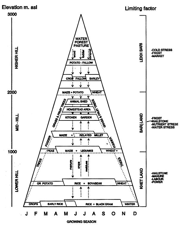
Numerous cropping patterns exist in the hills, and crop combinations vary greatly with altitude, climate and soil. On irrigated land below 1000m asl, three crops per annum are produced in the valley bottoms on khetland. At higher altitude (1000–1800m asl) a two crop system predominates, while only one crop is grown at altitudes above 1800m. The principles of the cropping systems in the hills have been well represented diagramatically by Sthapit (1983), and his scheme is reproduced as Figure 2. This clearly demonstrates that the cropping systems become progressively simpler as the altitude increases, the reason being a shorter length of cropping season available because of climatic constraint. Table 5 summarises the more common cropping patterns found in the mid-hills of Nepal.
Farming practices in the region are still very traditional, and over 75% of the land is ploughed by bullocks and subsequently worked by manual labour (Pandey, 1982). Apart from wheat which is a relatively recently introduced crop in some areas, local varieties generally predominate, though farmers with access to agricultural inputs are now turning to improved varieties to exploit their greater potential.
In addition to cereal crops, the region has a very good potential for horticultural crops. The most commonly grown fruits are banana, mandarin orange, lime, lemon, peach, plum, papaya, and apples in dryer, colder areas. Vegetable production is important, but where there is lack of a ready market nearby, vegetable seeds are grown for sale. Approximately 25% of the total country's demand for vegetable seed was produced from Lumle's Extension Command Area in the Western Hill Districts in 1990, providing a considerable cash income to the farmers involved.
Fig 2: The farming systems in the hills of Nepal as resulted by altitudinal variation. (from: Sthapit, 1983)
The whole farming system of the hills is still at a subsistence level and with annual food deficits in many places. However, much effort has been made to introduce modern technologies with improved varieties of crops, and other inputs such as fertilizer, agrochemicals and finance. In addition, intensive utilization of arable land, and proper management and utilization of natural resources is also encouraged.
Table 5: Common hill cropping patterns in the Hill Districts of Nepal.
| Altitude | Land type | Cropping patterns |
| <1000m | Khet | Rice-wheat-rice Rice-wheat-maize Rice-wheat-fallow Rice-fallow-rice |
| Bari | Maize-fingermillet-fallow Maize+soyabean-fallow Maize+upland rice-blackgram | |
| 1000–1500m | Khet | Rice-wheat-fallow Rice-potato Rice-fallow Rice/lentil or peas |
| Bari | Maize/fingermillet-wheat/barley Maize/fingermillet-fallow Maize/fingermillet-mustard | |
| 1500–2400m | Khet | Rice-fallow Buckwheat-wheat |
| Bari | Maize/fingermillet-fallow Maize/fingermillet-wheat/barley Maize-naked barley-fingermillet (2 years) Maize-fallow Potato fallow |
Source: Subedi (1990)
The whole cropping pattern in the region is dependant upon and influenced by the application of animal-based manure, and chemical fertilizers are seldom used, usually because of the price, or non-availability. Different crops remove substantial amounts of nutrients from the soil, with data for the three main arable crops being presented in Table 6.
Table 6: Major plant nutrients (N,P,K) removed from the soil by main arable crops of the Hill Regions of Nepal.
| Type of crop | Quantity of nutrient removed (kg/ha) | ||
| N | P | K | |
| Maize | 53 | 23 | 12 |
| Rice | 54 | 7 | 74 |
| Wheat | 30 | 23 | 32 |
Source: Sthapit et al (1987)
That these large quantities of nutrients are removed by different crops is well realised by farmers, although they are obviously unaware of the exact figures. To counteract this, farmers have adopted different traditional manuring methods to maintain their crop production profile. Among these methods some are efficient and some are not. According to Sthapit et al (1988), and Subedi et al (1989), different methods of manuring are practised by farmers for different land types, and crops. These are presented in Table 7. In addition to these methods, many other local practices exist which have not been recorded.
Table 7: Traditional manuring methods practised in the hills of Nepal.
| Manuring type | Practices/method | Type of level |
| 1. In-situ | - Goth system where cattle and buffalo sheds are kept in the field. - Migratory sheep and goats kept in open field during fallow winter period. | Bariland |
| 2. Manure and compost | - Heap and pit method. - With dung and leaf litter/agriculture residue. - Carry from animal shed to cultivated land before ploughing. | Bariland and Khetland |
3. Legume crop inclusion in rotation | - Planting blackgram, soyabean, lentil, cowpea etc. during winter. | Bari and Khetland |
| 4. Short fallow period | - Leaving land fallow once in every 3–4 years. | Bariland |
5. Burning of organic matter and crop residue | - Before ploughing for potato, Colocasia. - Common in shifting cultivation. | Bariland and Shurbland |
6. Slicing and burning of terrace risers | - Almost every year when terrace risers are without grass. | Khetland but rarely in Bariland |
| 7. Green manuring | - Paddy field with wild shrub like Asuro (Adatoda vasica), Titepati (Arteminia vulgaris) etc. well before planting. | Khetland |
| 8. Trapping of flood water | - During rainy season before planting/after planting paddy in the field. | Khetland |
9. Use of home and kitchen waste | - Not so common but in kitchen garden for vegetable. | Bariland |
Source: Sthapit et al (1989); Subedi et al (1989)
The traditional manuring practices for maintaining soil fertility are no longer sufficient to fulfil the nutrient demand of crops. Existing practices need improvement to realise sustainable crop production, but to achieve this, radical changes to the system need to be made, which are not possible at present. However, possibilities do exist for improving the soil status within the existing system itself, one of which would simply be to encourage better management practices while preparing and applying compost.
In the more accessible areas, farmers do use chemical fertilizers in combination with manure, especially when improved varieties of crops such as maize, wheat, and rice are grown. However, because of the great variation in soil properties of the region, blanket recommendations of fertilizers are not cost effective (Khadka and Chand, 1987), so there is little scope for widescale application of chemical fertilizers, under present circumstances. The amount of manure application varies greatly from land to land and crop to crop. Table 8 shows the quantity of manure application reported by different authors.
Table 8: Amounts of manure applied by farmers for different crops in the mid-hills of Nepal.
| Source | mt/ha | Crop | Land type |
| Heuch (1986) | 3 – 21 | - | - |
| Balogun (1989) | 58 | Maize-based cropping | Bariland |
| Subedi and Gurung | 20 – 28 | Maize/millet | Bariland |
| (1991) | 0 – 23 | Rice | Khetland |
These large quantities of manure application for sustaining arable cropping patterns are dependent upon natural resources and livestock. Because of this, the numbers of livestock per human inhabitant of Nepal, is amongst the highest in the developing world.
Consequently, for most farmers, the most important enterprise after arable cropping is livestock husbandry. It is the major source of food protein for people, in the form of meat and milk, but also supplies manure and draught power for maintaining land fertility and for land preparation. In addition, it is a potential cash insurance for farmers to tide them over the winter period, or through personal problems. However, it is also a very labour intensive activity, and much time is spent in collecting animal fodder and supervising grazing.
The other major role of livestock is the transfer of basic plant nutrients from the forest and grasslands to cultivated lands, in the form of manure. This cycle of transfer obliges the farmer to keep large numbers of animals, which has resulted in the Hill regions having the greatest number of livestock in the country.
Over 50% of cattle, 60% of buffalo, 57% of goats, 43% of sheep, 61% of pigs, and 73% of poultry are located in the hill regions and this high population of livestock is causing imbalance for the whole ecosystem, because of a substantial feed deficit on the one hand, and the low productivity of the animals on the other. Livestock production is well below its full potential, because of feed shortages during the winter months. At present, the acute feed shortage and over population of the livestock remain as problems, because livestock are regarded as a vital part of the hill farming system. There is a great need to implement programmes which will re-establish an ecological balance in the region.
Table 9: Livestock population of Nepal by physiographic region.
| Animal Species | Total (million) | Terai (million) | Mid-hills (million) | High Himal (million) |
| Cattle | 6.4 | 2.2 | 3.2 | 0.8 |
| Buffalo | 2.8 | 0.9 | 1.7 | 0.3 |
| Sheep | 0.8 | 0.1 | 0.3 | 0.4 |
| Goats | 4.9 | 1.3 | 2.8 | 0.8 |
| Pigs | 0.4 | 0.1 | 0.3 | 0.1 |
| Poultry | 7.0 | 0.6 | 5.1 | 1.3 |
Source: DFAMS (1985)
INTERRELATIONSHIPS BETWEEN THE SOIL, CROPS, LIVESTOCK AND FORESTS IN ANIMAL PRODUCTION
As stated, the complex farming systems of the mid-hills cannot be sustained unless all three components of crops, livestock and forest are considered in developing new or improved technology.
Livestock is a major earning resource, which is second in the contribution made to the GNP from the Agricultural Sector. Under such complex interactive farming systems, it is difficult to determine which part of the profile is the most efficient in its energy production and exchange, but the role of livestock is crucial in the ultimate derivation of energy for human survival in the form of carbohydrate from cereal grain production.
The major limitation faced in mid-hill livestock production is a deficit in feed, which has placed the whole region into ecological imbalance. The critical time of foodder/forage shortage is during the dry winter period of the year, October to April, and at this time the forest is the major supplier of fodder. According to a survey conducted by FAO (1979), animal feed consumption is about 9.5 million tonnes TDN per year for the whole country. Of this, more than seven million tonnes is derived from the forest and grassland in the mid-hills. This has placed the hill forests and grasslands under severe strain, causing further depletion and deterioration in these natural resources. Pandey (1982) reported that over 50% of total animal feed comes from the forest, of which 20% is from trees alone. In the Tinau Watershed Area, 30% of the feed requirement is derived from public land (forest) and grassland (Fronzen and Oberholzen, 1984). In the same way, Sharma and Pradhan (1985) have estimated that 46% of the total animal fodder/forage comes from the forest, and the bulk of this derives from fodder trees. Mahat et al (1987) stated that the fodder use per person is 7.5 times more than fuelwood in the Sindhupalchok and Kavrepalanchok Districts, and according to these authors, the forest is more heavily exploited for fodder than for fuelwood. These conclusions reveal that although the contribution of forest to fodder production varies from place to place, it is vital, and because the forests in the hills are heavily exploited for fodder collection, and are utilized for free grazing and browsing, livestock production in the hills would be extremely difficult without them.
The existing traditional hill farming system has been entirely dependant on locally available manure for maintaining soil fertility. Farmers in the mid-hills, under their present circumstances, generally cannot afford chemical fertilizers, both due to a lack of cash needed to purchase them, and the cost of transportation to remote areas. Furthermore, there is no properly established infrastructure for an assured supply in this inhospitable environment. Therefore, without organic manuring, farm crop production would decrease to a very low level. As a consequence, utilizing all the available organic manure, and minimizing soil erosion, has been the main process by which soil fertility has been maintained on hill farms (LRMP, 1986). Forest biomass and livestock are crucial components in this process, both to exploit and cycle the nutrients available in the region, and for this reason, large amounts of leaf litter (forest biomass) are collected every year to maximise compost production. Mahat (1985) has estimated that 2.3 mt/ha of leaf litter is used annually in the Sindhupalchok and Kavre areas. Similarly, Khadka et al (1984) reported that 50% of the litter is removed from the forests of the mid-hills annually for manuring purposes. Wyatt-Smith (1982) has estimated that at least three hectares of forest land are needed to maintain each hectare of arable land with livestock, without causing deterioration of the forest, livestock and the amount of manure produced. Organic manure yield is directly proportional not only to the numbers of livestock and numbers of stall-fed animals, but also to the quantities of forest biomass used for manuring (Mahat et al, 1987). Bedding is another important facet of livestock farming, because farmers depend upon the compost made from livestock manure mixed with bedding materials to supply nutrients essential for food production where crop residues are intensively used as a feed for livestock during the winter period. Farmers from Tapu village within the Extension Command Area (ECA) of Lumle, have to spend between two and four hours per day to collect one bhari (25–30kg) of leaf litter for animal bedding, due to the absence of forest near the village.
All these activities therefore depend ultimately upon the forest, and have contributed to the replacement of productive and palatable tree species with unpalatable species and weeds such as Eupatorium spp. (Shrestha, 1988). This will eventually have a negative impact upon the plant nutrient recycling system, resulting in poor livestock production and a continued decline in crop yields.
Because the agriculture production system in the region has a multidisciplinary approach, without which no sustainable agriculture can be conducted in the mid-hills, some farmers have adopted an agroforestry system, planting fodder/fuelwood trees and cereal crops together on the terrace risers of bariland, and on the bunds of khetland. Though the actual loss in crop yield from competition from the trees has yet to be fully quantified, farmers do report an adverse effect on crop yields. However, the need for trees to supply fodder to the livestock has obliged the retention of trees in and around cultivated land, and the losses in crop yield are accepted as part of the price to be paid to sustain the system. The actual effect of the tree on the crop needs to be studied and accurately measured, because only then can recommendations be made that will eventually assist farmers to manage tree species with minimal loss of crop production on cultivated land.
Over the winter period, crop residues make a major contribution to the feed resources of livestock, and crop residues provide 16% of the total feed requirement of the region (Pandey, 1982). For this reason, farmers store crop residues such as rice straw, millet straw and maize stover. According to a survey conducted by Sharma and Pradhan (1985), 2.9 million tonnes of roughage is produced annually in the mid-hills of Nepal, of which about 2 million tonnes is consumed by animals, along with some green fodder. The remainder is used for roofing and bedding in livestock housing. Farmers therefore give high priority to selecting crop varieties which will produce good yields of both grain and straw. The importance of rice straw has led farmers to reject high yielding short straw rice varieties in favour of lower yielding long straw types (Shrestha, 1988; Sthapit et al, 1989). The lack of sufficient straw in the Western Hills at least, has now led to a trade in straw, for which a price of Rs. 60–80 per head load (40–50kg) is charged.
The vegetable crops grown in the hills can also provide a source of fodder. Though their contribution as livestock feed has been neglected by many researchers, considerable amounts are used by farmers as an animal feed. Data on the amounts of fodder available from green vegetables after preparation for human consumption are not available, but one study by Sen et al (1986) estimated that various vegetables, such as cabbage, cauliflower and radish can give amounts of fodder ranging from 44–48% of the total mass of vegetable grown.
CASE STUDY
Problems and Constraints in the Farming System of Lopre Village
As an example to demonstrate the concepts discussed in this chapter, a case study from a mid-hill village, Lopre, gives a clear picture of how the livestock, forestry and cropping patterns are interrelated and interdependent.
Lopre is a village within in Lumle's ECA in Parbat District, situated at 2400m asl. The total population of the village is 335 individuals in 62 households. The average cattle holding per household is over five (including calves and oxen). At the start of Lumle's intervention there was no khetland in the village, so almost all land was bariland and with a large proportion uncultivated. In addition, some kharbari land for growing thatching grass was available.
Almost 70% of farmers reported having uncultivated fallow land due to a shortage of compost, low soil fertility, and labour shortage. The forest resource was limited to a few coniferous patches on the hill tops, and a shortage of animal forage/fodder was another major constraint to realising a sustainable farming system. The lack of forest for fodder collection, as well as low levels of crop production from which to realise sufficient crop residues which could eventually be used to give greater manure production for compost making, were also major constraints. These extreme shortages of fodder, leaf litter and fuelwood in turn caused a labour shortage in the village, because people had to spend a large proportion of their time in fetching fodder, fuelwood and leaf litter from other areas, and in supervising animals grazing at considerable distances from the village. Very few trees could be grown in the bariland due to the prevailing climate at that altitude, which was not conducive to fodder tree growth. Although the villagers had a practice of collecting pine (Pinus wallichiana) needles for making compost, this was still insufficient to meet their needs. This downward spiral in which the villagers were trapped could be ascribed to the absence of sufficient forest resources near the village, which restricted animal feed, resulting in very poor performance of livestock, and so little production of manure. This in turn caused lower crop yields and so there were insufficient crop residues to feed back to the livestock. This decrease in food availability to meet the year round needs of the villagers led to food deficit, and resulted in outmigration of people to earn money elsewhere in order to survive. Under these circumstances there was need to develop a policy to reverse this downward spiral and intensify farming in the area.
The following policy has been adopted to attempt to reverse these trends by managing the available natural resources according to the following plan.
Development of existing forest resources can be done by implementing proper management practices, and also by introducing more palatable fodder/multipurpose tree species. The aim is to convert the pure pine (Pinus wallichiana) forest into a mixed forest with species diversity. Trials have demonstrated that fodder trees can be successfully established and grown at the altitude of Lopre, if planted to the leeward side of indigenous pine trees to given shelter from the prevailing wind. In addition planting of fodder/multipurpose trees and forage on communal, uncultivated bari and kharbari lands will produce additional fodder/forage.
These activities will eventually alleviate the present fodder deficit situation of the village by generating surplus fodder/forage to feed the livestock.
The development of forest resources will mean that farmers can eventually be made self-sufficient in food by bringing back more fallow-land into production which in turn will give more agricultural crop residues for livestock feeding. Lopre is a one crop area, but by research into time of planting, it has been demonstrated that it is possible to grow a wheat crop in addition to the usual potato/buckwheat (LAC, 1990; 1991). This will also help to alleviate the food deficit, and produce more crop residues, which in turn can be fed to the livestock.
In summary, for successful livestock farming, the trees, crops, the animals themselves, and the soil are interdependent components, and the relationship among them is very deep. None should be ignored if the farming systems in the hills are to be maintained.
The present levels of crop and livestock production, which are substantially below the potential possible, and the rapid disappearance of forest resources have created an alarming situation in the traditional farming systems of the hills of Nepal, but with care and if proper strategies, such as the example outlined above, are implemented for the future, this trend can be reversed, and ultimately it should be possible to correct the situation, without the disastrous consequences prophesied by many.
REFERENCES
Balogun, P.A.K. (1989). A discussion of crop-cut estimates of rice, maize and millet yields in the Extension Command Area of Lumle Agricultural Centre. LAC Technical Paper 6, Lumle Agricultural Centre, Kaski, Nepal.
CBS (1985). Central Bureau of Statistics. His Majesty's Government of Nepal, Kathmandu, Nepal.
CBS (1986). Central Bureau of Statistics, Population Statistics of Nepal. His Majesty's Government of Nepal, Kathmandu, Nepal.
DFAMS (1985). Department of Food and Agricultural Marketing Services. Report on food production and water use at the farm level. His Majesty's Government of Nepal, Kathmandu, Nepal.
Dobremez, J.F. (1976). Le Nepal, ecologie et biogeographie Paris, France. CNRS (cited by Jackson, 1987).
FAO (1979). Agriculture Sector Review, Nepal. FAO, Rome, Italy.
Fonzen, P.F. and Oberholzen, E. (1984). Use of multipurpose trees in the hill farming system of western Nepal. Agroforestry Systems 6, 187–197.
Goldsmith, P.J. (1981). The land and soil resources of the KHARDEP Area. KHARDEP Report 16, pp 1–95.
Gorkha Patra (1991). The Gorkha Patra, 11 September, 1991 edition.
Heuch, J.H.R. (1986). The quality of compost applied to farmers' fields and its relevance to forest management in the mid-hills of Nepal. LAC Technical Paper 86/11. Lumle Agricultural Centre, Kaski, Nepal.
HMG/SATA (1980). Tinau Watershed Management Plan (Vol. 1). Tinau Watershed Project. His Majesty's Government of Nepal/Swiss Association for Technical Assistance.
Jackson, J.K. (1987). Manual of Afforestation in Nepal. Forest Survey and Research Office, Department of Forest, Kathmandu, Nepal.
Karki, N.P.S. (1984). Livestock and feed resources in the hills of Nepal from the example of the Command Area of Lumle Agricultural Centre. Paper presented at the Forestry Workshop held at Lumle Agricultural Centre, 24–27 January, 1984.
Khadka, R.J., Shrestha, J. and Tamrakar, A.S. (1984). Ecology of Godawari. In: Nepal - Nature's Paradise, pp 408–437. (Ed: T.C. Majpuri). White Lotus Co., Bangkok, Thailand.
Khadka, R.J. and Chand, S.P. (1987). The organic materials: a valuable source of soil nutrients in the Eastern Hills of Nepal. PAC Working Paper 12/87. Pakhribas Agricultural Centre, Dhankuta, Nepal.
Laban, P. (1979). A preliminary appraisal of land mass movement in Nepal. Journal of the Nepal Research Centre 2/3, 97–108.
LAC (1990). Lumle Agricultural Centre, Annual Report 1989/90. P.O. Box 1, Pokhara, Gandaki, Nepal.
LAC (1991). Lumle Agricultural Centre, Annual Report 1990/91. P.O. Box 1, Pokhara, Gandaki, Nepal.
LRMP (1986). Land Resource Mapping Project, Agriculture Forestry Report. Present land and potential for improvement, p55. His Majesty's Government of Nepal/Government of Canada.
Mahat, T.B.S., Griffin, D.M. and Shepherd, R.R. (1987). Human impact on some forests of the middle hills of Nepal. Forest in the subsistence economy of Sindhupalchok and Kavrepalanchok. Mountain Research and Development 7.
Mahat, T.B.S. (1985). Human impact on forests in the middle hills of Nepal. PhD Thesis, Australian National University, Canberra, Australia.
Pandey, K.K. (1982). The livestock-fodder situation and potential fodder resources. Mountain Development and Environment - A collection of papers published on the 20th Anniversary of SATA, pp 47–60. Sahayogi Press, Kathmandu, Nepal.
Sharma, L.P. and Pradhan, D.R. (1985). Present fodder resources and prospects for their development in the hills of Nepal. In: Livestock in the hills of Nepal. Proceeding of a Livestock Workshop held at Pakhribas Agricultural Centre, Dhankuta, Nepal.
Sen, C.K., Sthapit, B.R., Joshi, B.R. and Heuch, J.H.R. (1986). LAC's FSR experience and results to date. Paper presented at FSR New Working Group Meeting held at Pokhara, 11–15 August, 1986.
Shrestha, T.B. (1982). Ecology and Vegetation of North-West Nepal. Royal Nepal Academy Silver Jubilee Publication No. 23 Kathmandu, Nepal.
Shrestha, R.K. (1988). The fodder tree situation and its management in the mid-hills of Nepal. MSc Thesis University College of North Wales, Bangor, UK.
Soil Survey Staff, USDA (1975). Soil Taxonomy. Agricultural Handbooks No. 436. Washington D.C., USA.
Sthapit, B.R., Joshi, K.D., Dhital, B.K., Gurung, J., Vaidya, A., Pradhanang, P.M., Kadayat, K.B. and Subedi, K.D. (1989). A research report on early upland and normal rice conducted at LRARC and its RCA. Paper presented at Summer Crops Workshop, 4–9 February, 1990, held at the National Rice Improvement Project, Parwanipur, Nepal.
Sthapit, B.R., Gautam, M., Ghale, N., Gurung, D.B., Gurung, J., Gurung, K.J., Paudel, D.R.S. and Subedi, K.D. (1988). The results of a soil fertility thrust Samuhik Bhraman: traditional methods of sustaining crop productivity in the lower hills (300–700m asl): Problems and potentials. LAC Technical Paper 88/19. Lumle Agricultural Centre, Kaski, Nepal.
Sthapit, B.R. et al (1987). Lumle Report on soil fertility research. LAC Technical Paper 87/13. Lumle Agricultural Centre, Kaski, Nepal.
Sthapit, B.R. (1983). Soyabean production in the hills of Nepal. MSc Dissertation, University of Reading, U.K.
Subedi, K.D., Gurung, G.B., Paudel, D.R.S., Gurung, K.J., Gurung, D.B., and Gurung, J.B. (1989). Traditional methods of maintaining soil fertility in the mid and high hills (1200–2100m asl) of the Western Development Region of Nepal (Kaski and Lamjung Districts): Problems and Potentials. LAC Working Paper 3/89. Lumle Agricultural Centre, Kaski, Nepal.
Subedi, K.D. and Gurung, G. (1991). Soil fertility thrust towards sustainable agriculture: experiences of Lumle Regional Agricultural Research Centre (LRARC). LAC Technical Paper 4/91. Lumle Agricultural Centre, Kaski, Nepal.
Subedi, K.D. (1990). Study of maize/finger millet relay intercropping in the hills of Nepal: measures for production maximization. MSc Thesis, University of Reading, UK.
Tamang, D., 1991. Indigenous soil management systems in the Jhikhukhola Watershed. In: Soil Fertility and Erosion Issues in the Middle Mountains of Nepal, pp 135–151. IDRC, Ottawa, Canada.
Wyatt-Smith, J., (1982). The agriculture system in the hills of Nepal. The ratio of agricultural land and the problem of animal fodder. APROSC Occasional Paper 1, Kathmandu, Nepal.
![]()
![]()
![]()