Step 5. Evaluate land suitability
This step forms the central part of land evaluation, a procedure which answers the following questions:
• For any specified kind of land use, which areas of land are best suited?
• For any given area of land, for which kind of use is it best suited?
A systematic way of doing this is set out in A framework for land evaluation (FAO, 1976) and detailed procedures are given in guidelines on evaluation for rain-fed agriculture, irrigated agriculture, forestry and extensive grazing (see Land evaluation, p.81). In simplified form, the procedure is:
• describe promising land-use types;
• for each land-use type, determine the requirements, e.g. for water, nutrients, avoidance of erosion;
• conduct the surveys necessary to map land units and to describe their physical properties, e.g. climate, slope, soils;
• compare the requirements of the land-use types with the properties of the land units to arrive at a land suitability classification.
Land cannot be graded from "best" to "worst" irrespective of the kind of use and management practiced because each kind of use has special requirements. For example:
• Rice has high water requirements and most varieties grow best in standing water; no other cereal crop will tolerate waterlogging during its period of active growth.
• Tea, sugar cane and oil-palm need efficient transport to processing plants; most crops grown for subsistence do not.
• For mechanical operations, stones and rock outcrops are limiting; with oxen or hand implements, cultivation can work round these obstacles.
Description of land-use types
A land-use type is a kind of land use described in terms of its products and management practices (Table 3). For reconnaissance surveys at the national level, highly generalized descriptions may be sufficient, e.g. "sorghum production", "conservation forestry". At the district and local levels, it is necessary to specify the use in more detail. For example, will the sorghum production be mechanized or based on animal traction? Will fertilizer be used? Will the conservation forests be managed by the government forestry service or by local communities?
Such descriptions serve two purposes. First, they are the basis for determinating the requirements of a use. Second, the management specifications can be used as a basis for extension services and for planning necessary inputs.
The land-use types will be based on the promising improvements identified in Step 4. They may be modifications of existing uses, such as incorporating fodder trees or soil conservation measures, or something new to the area, such as the introduction of a new cash crop.
Selection of land qualities and land characteristics
Land-use requirements are described by the land qualities needed for sustained production. A land quality is a complex attribute of land that has a direct effect on land use. Examples are the availability of water and nutrients, rooting conditions and erosion hazard (Table 4). Most land qualities are determined by the interaction of several land characteristics, measurable attributes of the land. For example, the quality "availability of water" is determined by the balance between water demand and water supply. The demand is the potential evaporation from the surface of the crop and the soil; the supply is determined by rainfall, infiltration, storage of water in the soil and the ability of the crop to extract the stored water.
In the case of "availability of water", it is practicable to calculate reliable quantitative values for the land quality. The water demand of a leafy perennial crop, such as sugar cane or rubber, is much greater than that of a crop with a short growing period, for example beans. A soil water storage capacity of 200 mm might be enough in a humid area but not enough where seasonal droughts occur. For major crops, quantitative models have been developed to estimate crop yields under a range of quality values.
TABLE 3
Description of a
land-use type
TITLE | Rice cultivation by smallholders |
PRODUCTION Marketing arrangements, yields | Grain for subsistence, surplus sold in local market. Straw fed to draught animals. Average yield, 2.6 t/ha. When water is not limited, wet-season yield may be 4 t/ha and dry-season yield may be 5 t/ha |
MANAGEMENT UNITS Size, configuration, ownership | Family-owned plots from 0.2 to 2 ha, usually associated with as many as 4 ha of upland which may be up to 2 or 3 km distant |
CULTIVATION PRACTICES AND INPUTS Labour, skill, power, varieties, seeds, agrochemicals | Labour requirements from 200 person-days/ha without mechanization to 150 person-days/ha where buffaloes or tractors are used Terraced fields need extra labour to maintain bunds and waterways |
Power requirements. Power for ploughing, harrowing and threshing may be provided by two-wheeled tractors. Alternatively, buffaloes may be used for land preparation or all work may be manual. Tractors may reduce tillage time by 60% and total time between crops by 30% | |
Land preparation seeks to control weeds, create a good physical medium for rooting and reduce water seepage loss. This is achieved by ploughing or hoeing twice, followed by harrowing under flooded conditions | |
Recommended varieties. Varieties are selected locally to suit specific sites and according to the season. The growing period must be long enough to span the flood period and to allow cultivation and harvesting under favourable conditions. | |
Planting rates are 20 to 40 kg/ha, seedlings are spaced from 20x20 to 25x25 cm depending on tillering capacity and length of stalks | |
Fertilizer. To replace nutrients removed by a crop of 4 t/ha requires 60 kg N. 30 kg P2O5 | |
Weed control by maintaining adequate water depth and hand weeding until the crop canopy is closed | |
Pests and diseases. Chemicals used to control rice blast and stem borers. Good husbandry and resistant varieties control other fungal diseases | |
CROPPING CHARACTERISTICS | Rice is grown as a monoculture, one or two crops per year. Fallow land is grazed by draught buffaloes and other domestic livestock |
WATER | Most crops are rain fed, with water stored in level, bunded fields. Irrigation, from tanks or by stream diversion, enables a second crop to be grown in the dry season |
In any particular project, only a limited number of land qualities need be selected for use in evaluation. Criteria for selection are:
• The quality must have a substantial effect either on performance or on the costs of production. Some qualities affect most kinds of land use, for example "availability of water"; others are more specific, for example "conditions of ripening" is a quality that affects grain crops but not rubber.
• Critical values of the quality must occur in the planning area. If a quality is adequate everywhere, there is no need to include it. For example, most tropical crops are sensitive to frost but, in most parts of the lowland tropics, the land quality "frost hazard" need not be considered.
TABLE 4
Land qualities for
rain-fed farming
Land qualities | Land characteristics that measure the quality |
Availability of energy | Sunshine hours in growing season, temperature regime |
Availability of water | Evaporative demand set against rainfall, soil water storage and rooting conditions |
Conditions for ripening | Period of successive dry days with specified sunshine and temperature |
Climatic hazards | Frequency of damaging frost, hail or winds during growing period |
Sufficiency of oxygen in the root zone | Soil drainage class, depth to water-table |
Sufficiency of nutrients | Soil nutrient levels, pH, organic matter content |
Erosion hazard | Rainfall and wind erosivity set against soil cover, slope angle and length and soil permeability |
Toxicity | Levels of soluble Al and Fe; pH |
Having selected relevant land qualities, it is necessary to decide which land characteristics are to be used for measuring them. For example, the quality "erosion hazard" requires information on rainfall intensity, slope angle and soil properties.
A compromise must be reached between characteristics that most closely define the land quality and those that are less precise but on which information is more readily available. Out of necessity, the choice is limited to those characteristics for which information is already available or can be gathered quickly. If there is no information on a critical land quality, surveys must be carried out or research initiated.
Land evaluations are sometimes conducted directly in terms of land characteristics, e.g. by using rainfall instead of availability of water, slope angle instead of erosion hazard. There is, in fact, a hidden use of land qualities in this way of doing things, since plants do not actually require rainfall but do require water (which might alternatively be obtained from a high water-table in a dry area, for example). In practice, evaluations carried out carefully using either qualities or characteristics give quite similar results.
Mapping of land units and their characteristics
In Step 3, land units were identified as a basis for the diagnosis of problems. It may now be necessary to map these units in more detail, e.g. by dividing land systems into land facets or complex soil mapping units into soil series. The criterion for choice of land units is that they are expected to respond to management in a relatively similar way at the scale of the study.
Whether it is now necessary as part of the land-use plan to conduct original surveys depends on the requirements of the plan and the detail and reliability of the information available. Soil surveys, agroclimatic studies, forest inventories and pasture resource inventories are major sources. For land-use planning at the national level, reconnaissance surveys at scales of about 1:250000 may be adequate; district-level planning will need at least semi-detailed surveys at a scale of about 1:50000.
Natural resource surveys take a substantial amount of time and will delay the planning procedure. However, past experience has shown that to proceed with land development projects without adequate resource data can lead to disasters, both for production and conservation. In practice, resource surveys and studies of land-use types can proceed at the same time, with frequent interchanges of information.
TABLE 5
Structure of the FAO
land suitability classification
S | SUITABLE | The land can support the land use indefinitely and benefits justify inputs |
S1 | Highly suitable | Land without significant limitations. Include the best 20-30% of suitable land as S1. This land is not perfect but is the best that can be hoped for |
S2 | Moderately suitable | Land that is clearly suitable but which has limitations that either reduce productivity or increase the inputs needed to sustain productivity compared with those needed on S1 land |
S3 | Marginally suitable | Land with limitations so severe that benefits are reduced and/or the inputs needed to sustain production are increased so that this cost is only marginally justified |
N | NOT SUITABLE | Land that cannot support the land use on a sustained basis, or land on which benefits do not justify necessary inputs |
N1 | Currently not suitable | Land with limitations to sustained use that cannot be overcome at a currently acceptable cost |
N2 | Permanently not suitable | Land with limitations to sustained use that cannot be overcome |
Examples of classes in the third category | ||
S2e | Land assessed as S2 on account of limitation of erosion hazard | |
S2w | Land assessed as S2 on account of inadequate availability of water | |
N2e | Land assessed as N2 on account of limitation of erosion hazard | |
Note: There is no standard system for letter designations of limitations; first-letter reminders should be used where possible.
Setting limiting values for land-use requirements
Limiting values are the values of a land quality or land characteristic that determine the class limits of land suitability for a certain use. The standard FAO land suitability classification is shown in Table 5.
The first and most important decision is to separate land that is suitable from that which is not. Important criteria for deciding on the suitability of land for a specific use are sustainability and ratio of benefits to costs.
• The land should be able to support the land use on a sustained basis. This means that the use must not progressively degrade the land. Many changes of land use cause an initial loss of land resources: for example, when forest is cleared for tea plantations or for arable farming, there is always a loss of forest habitat and wildlife as well as of soil and accumulated plant nutrients.
From then on, a good level of productivity must be maintained by the new system of management. For example, if soil erosion is not controlled, the new land-use type cannot be sustained. According to the land-use type, the upper limit of the land quality "erosion hazard" might be set in terms of slope, as follows:
- plantation tea, high level of management: 20
- smallholder tea, average level of management: 15
- rain-fed arable crops with simple soil conservation practices: 8
• The use should yield benefits that justify the inputs. The user has to make a reasonable living from the land. Local experience will usually be the best guide. Alternatively, a financial analysis can be undertaken.
It is then possible to distinguish up to three classes of suitability, although this is not always necessary. Land classed as highly suitable is the best land for the specified use; moderately suitable land is clearly fit for the use but has limitations; while marginally suitable land falls near to (but above) the limit for suitability. Land that is not suitable may be subdivided into permanently not suitable, where there are limitations to sustained use that are clearly impractical to overcome; and currently not suitable, where such limitations could be overcome but not at a currently acceptable cost.
TABLE 6
Example of land
requirements for a specified land-use type (bunded rice)
| Land qualities | Land characteristics | Limiting values for land characteristics | |||
| S1 | S2 | S3 | N | ||
| Sufficiency of energy | Mean annual temperature, (°C) or | >24 | 21-24 | 18-21 | <18 |
| Elevation (m)* | 0-600 | 600-1200 | 1200-1800 | >1800 | |
| Sufficiency of water | 75% probability rainfall (mm) | >1300 | 900-1300 | 500-900 | <500 |
| Soil drainage class | Poorly drained | Imperfectly drained | Moderately well drained | Excessively drained | |
| Soil texture | C, ZC, ZCL, L | SC, SCL, ZL, Z | SL | S, LS | |
| Soil depth (cm) | >80 | 60-80 | 40-60 | <40 | |
| Sufficiency of nutrients | pH of flooded soil | 6-7 | 5 6 | 4.5-5 | <4.5 |
| 7-8 | 8-8.5 | >8.5 | |||
| Salinity hazard | ECe (mS cm-1) | <3 | 3-5 | 5-7 | >7 |
| Ease of water control | Slope angle (degrees) | <1 | 1 -2 | 2-6 | >6 |
| Ease of cultivation | Stones and rock outcrops (%) | Nil | 1-5 | 5-10 | >10 |
* Elevation
is used to assess sufficiency of energy where temperature data
are not available; these values apply to Sri Lanka.
Source: Dent and
Ridgway (1986).
The construction of a table of limiting values for each land suitability class (see Table 6) is a central operation in land evaluation. To do this, information is needed on the performance of a land-use type over a range of sites, taken either from trials or the experience of land users.
The land requirements for several individual crops can be combined to assess the needs of a land-use type that includes several crops grown together or in rotation.
Matching land use with land
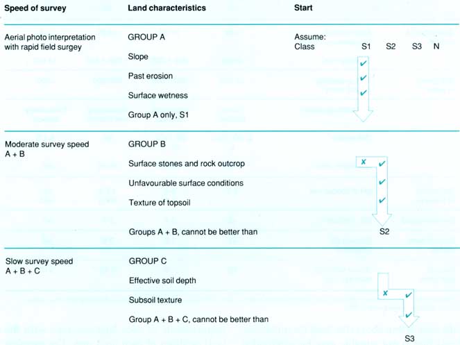
The first stage in matching is to compare the requirements of each land-use type with the land qualities of each land unit. The simplest procedure is to:
• check measured values of each land quality or characteristic against the class limits;
• allocate each land unit to its land suitability class according to the most severe limitation (Fig. 8).
For cases in which at least one limitation is enough to render the land unsuitable for the use, the method of taking the most severe limitation is valid. For example, for maize cultivation it is of no use having level land and sufficient rainfall if the soils are highly saline. For less severe values of limitations, alternative methods of combining ratings for individual qualities can be used.
Matching, however, can become a wider process than the simple comparison of requirements with qualities. Wherever this initial comparison shows certain land units to be unsuitable for a given use, the specification of the land-use type can be examined to see if, by modifying it, the suitability of those land units can be raised.
Figure 8: Example of the process of qualitative land suitability classification
Thus, if suitability has been downgraded owing to erosion hazard, a new land-use type could be designed with the addition of contour-aligned hedgerows or other soil conservation measures. The use of fast-maturing crop varieties in areas with a short growing season is another example. By adapting the land-use types to meet the limitations present in the area in this way, higher overall suitabilities can be achieved.
A further possibility is the introduction of land improvements, inputs which bring about relatively permanent improvements in the characteristics of the land. Examples are drainage of land that is too wet or terracing of steeplands. In this way, the land is adapted to the requirements of the land use. Land improvements invariably require maintenance as well as capital expenditure.
Qualitative and quantitative land evaluation
Some decisions need only qualitative land evaluation: for example, identifying the critical importance of certain areas for important land uses such as for an export crop. Quantitative economic evaluations, however, require estimates of crop yields, rates of tree growth, or other measures of performance. It is not realistic to predict the performance of each land suitability class unless data are available on plant growth (or other measures of performance) and the relevant inputs from well-characterized sites, and unless the physical characteristics of the land mapping units are equally well known. Quantitative models have been developed for several major crops but these demand good data. Even when predictions are based on carefully controlled trials, they may be confounded in practice by variations in management. Therefore, try to estimate a range of performance under the likely standards of management.
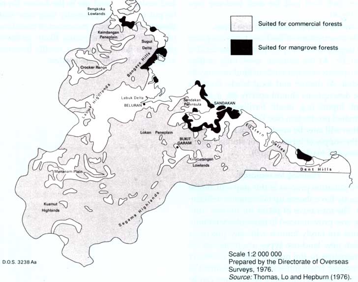
Figure 9: A land suitability map: areas suited for forestry, Sandakan Residence, Sabah, Malaysia
Scale
1:2000000
Prepared by the Directorate
of Overseas Surveys, 1976.
Source: Thomas, Lo
and Hepburn (1976).
Land suitability classification
The comparison of requirements of land-use types with properties of land units is brought together in a land suitability classification. Suitability is indicated separately for each land-use type, showing whether the land is suitable or not suitable, including - where appropriate - degrees of suitability (Table 5). The major reasons for lowering the classifications, i.e. the land limitations, should be indicated (because of erosion hazard in one area or a high water-table in another, for instance). In large or complex surveys involving many mapping units land evaluation can be assisted by the use of geographic information systems (see p. 77). A major facility is that, if the land suitability data are entered into such system, when a change is made to one or more limiting values, new maps of land suitability can be rapidly produced.
The outputs from Step 5 are:
• land suitability maps, showing the suitability of each land unit for each land-use type (Fig. 9);
• descriptions of these land-use types.
The descriptions of land-use types are given in a degree of detail appropriate to the level of planning. At the national level, only outline descriptions of major kinds of land use may be needed. At district and local levels, land-use type descriptions should specify the management, inputs (e.g. seeds, fertilizer, fuel) and estimated production (see Table 3). Such information will later be needed to make provision for the supply of inputs and for storage, distribution and marketing (Step 9).
Planning for research
The evaluation process in this step will almost certainly have shown up information deficiencies. The tolerances of plants (or of crop cultivars, tree provenances) to particular land limitations are rarely known with any precision. Where new land-use types are proposed for introduction to the area, it will be necessary to conduct trials (on-station and on-farm) to validate their performance before they can be safely recommended for adoption. Gaps in knowledge of land resources may also have been revealed, thus calling for additional surveys.
It is impracticable to delay the land-use plan until all such research has been completed; but, at the same time, it is unwise to proceed if there is a serious lack of information. Action can be taken in two ways:
• Outside the land-use plan. Draw the attention of national and international research agencies as well as universities and donors to the need for research in specified aspects if land development of the area is to proceed on a proper basis of knowledge.
• Within the land-use plan. Based on existing local institutions (strengthened if necessary), set up trials or other research activities as part of the land-use plan itself.
Either of these ways will form a "research loop", feeding back information for making more reliable evaluations and more productive and sustainable land use in the future. Do not be put off by the apparently long time scale, three to five years as a minimum, of most kinds of research. By anticipating likely problems, there is a better chance of results becoming available when they are needed.
CHECKLIST Responsibility: planning team • Describe land-use types in sufficient detail for subsequent analysis. • Select land qualities and land characteristics to be used in comparisons of land-use requirements with land. • Map the land units and determine their relevant land characteristics and qualities. • Set limiting values to land-use requirements, to be used for determining class limits for land suitability. Take into account sustainability and the ratio of benefits to inputs. • Match land use with land:
• Map land suitability for each land-use type. • Plan for research needed: additional surveys, research by outside agencies or within the land-use plan. |