Step 7. Choose the best option
Planning as a decision support system
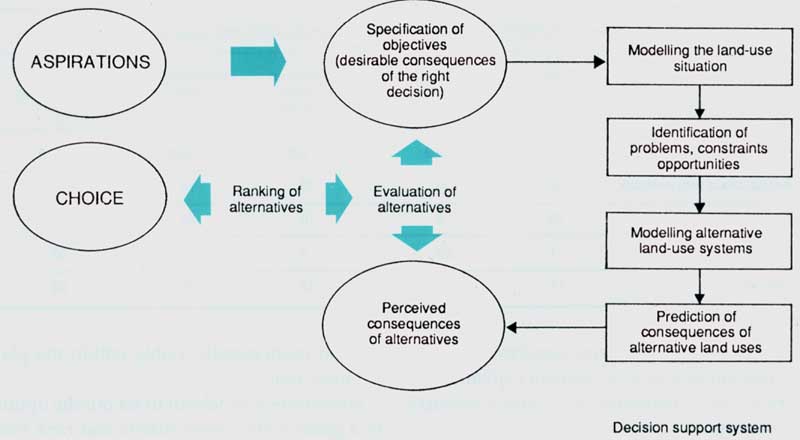
At the point of decision, the roles of the planner and the decision-maker must interact. The planner has to assemble and summarize the facts needed to make an informed decision - namely the results obtained from the previous steps. The decision-maker has to choose the land-use option that best meets the goals.
Figure 12 represents decision-making as a process of choosing between a range of options, with the preceding steps of land-use planning shown as a decision support system. It may be obvious which option is best, or else the choice may involve careful judgement.
In simple cases, a good decision may be made by intuitively weighing the evidence that has been built up through the previous steps of planning.
Land-use allocation, recommendation and assistance
In the simplest planning situation, that of new land settlement, land units can be allocated to specific uses. Settlers are then brought in and, at least initially, required to practice those uses.
Far more commonly nowadays, the land is already settled and is being cultivated, grazed, etc., so the purpose of the plan is to help solve problems of existing land-use systems. In this situation, land use cannot be simply "allocated". New land-use types can be recommended for specific areas, through extension services and through provision of inputs and services.
Decisions on land allocation or land-use recommendation for competing uses begin with:
• a set of policy guidelines, for example - a minimum acceptable production of staple foods and fuelwood, the preferred location within range of existing services and a limited amount of development capital;
• land units, delineated by a natural resource survey;
• land-use types, designed to be sustainable and economically viable within the planning area.
Sometimes it is helpful to set out the options in a goals achievement matrix and rank them according to the chosen criteria. Table 7 gives an example. First, the predicted performance of several promising land-use types is set out according to four criteria. Next, the options are rated according to how well they satisfy each criterion. Finally, weightings are allotted to each criterion, reflecting the decision-maker's judgement of the extent to which it should influence land use. No one is likely to make a decision solely on the "percentage goals achievement", but this procedure draws attention to the subjective weightings that are being used and the less beneficial as well as the favourable consequences of a particular decision.
TABLE 7
Example of a goals
achievement matrix: Dedza District, Malawi
1. Data from Step 6
Land-use type | Net income (#) per ha | Net income (#) per caput | Population carrying capacity per km² | Environmental impact |
Annual crops with livestock, improved management, 1.6 he farms | 113 | 36 | 312 | Moderate |
Annual crops without livestock, improved management, 3 ha farms | 50 | 30 | 167 | Moderate |
Coffee, improved management, 1.6 he farms | -10 | -16 | 156 | Low |
Ranching | -2 | 75 | 3 | Low |
Forestry | 63 | 51 | 63 | Low |
2. Goals achievement, as a percentage of the best option for each criterion
Land-use type | Return per ha | Return per caput employed | Population carrying capacity | Environmental impact |
Annual crops with livestock | 100 | 48 | 100 | 70 |
Annual crops only | 44 | 40 | 54 | 60 |
Ranching | 2 | 100 | 1 | 90 |
Forestry | 56 | 68 | 40 | 100 |
3. Goals achievement, weighted by the decision-maker's judgement of the importance of each criterion
Land-use type | Return per ha | Return per caput | Population carrying capacity | Environmental impact | Total goals achievement |
Weighting | 0.3 | 0.2 | 0.3 | 0.2 | 1.0 |
Annual crops with livestock | 30 | 10 | 30 | 14 | 84 |
Annual crops only | 13 | 8 | 16 | 12 | 49 |
Ranching | 1 | 20 | 1 | 18 | 39 |
Forestry | 17 | 14 | 12 | 20 | 63 |
Source: Dent and Young (1981).
TABLE 8
Example of a summary
table of land use: Walapane AGA, Sri Lanka
Land use by crop | Potential area | Area actually used | Areas planned for change this year | Estimated production this year |
(hectares) | (tonnes) | |||
Irrigable land | ||||
Double cropped rice | 1840 | 650 | +140 | 1500 |
Single cropped rice | - | 450 | -32 | 800 |
Rain-fed arable land | ||||
Bunded rice | 2250 | 1610 | -108 | 1750 |
Tobacco | - | 1900 | -300 | ... |
Subsistence upland crops | <4 000 | 2000 | -200 | ... |
Other chena land | - | 2320 | -100 | ... |
Improved mixed cropping + livestock | - | 48 | +200 | 140 l.u. |
Tea | ||||
Estate seedling | - | 6500 | -120 | 3900 |
Clonal | 5250 | 370 | +120 | 250 |
Smallholders | - | 120 | No change | 48 |
Forest | ||||
Dense | 29980 | 1630 | No change | Reserve |
Open | - | 3110 | No change | ... |
Scrub | - | 1190 | -280 | ... |
Plantation | - | 4780 | +400 | 4000 m³ |
Grassland | Not estimated | 1070 | No change | 400 l.u. |
Urban | Not estimated | 10 | No change | - |
Water | 490 | 490 | No change | - |
Unusable land | 130 | 130 | No change | - |
Note:
... data not available.
l.u. = livestock units.
The tasks of storage, retrieval and interpretation of a large and heterogeneous mass of information can be assisted by computerized methods. These can be used for the repetitive task of comparing the predicted performance of land units against multiple criteria and can present the user with the consequences of alternative decisions in terms of the optimum land-use pattern and goals achievement.
For the increasingly complex tasks of selecting sites for development projects, allocating land among several land uses, developing policies on land use as well as allocating resources, hundreds of individual land units and many alternative land uses may have to be considered. The decision-maker must take into account a variety of practical considerations, including:
• the expressed preferences of the local people;
• the interests of minority groups;
• national policies;
• constraints, e.g. of land tenure and availability of inputs;
• the maintenance of environmental standards;
• practicability - potential implementing agencies should be consulted;
• costs and the availability of funding.
TABLE 9
Example of a tabular
plan format1
Land units | Mountains | Basins | ||
12-28° slopes | Terrace | Bottomland | Steep knolls | |
Present land use | Subtropical mixed broadleaf forest, 30% degraded | Well-managed paddy. tobacco and vegetables | Badly managed tea or waste | |
Problems | Accessibility, landslips, soil erosion on recently logged sites | Water shortage in dry periods: low incomes. modest rice yield on coarser soils. Flooding in bottomland. Water pollution from paper mill effluent | Severe soil erosion: low yields | |
Planned changes | Replant degraded land. Bamboo and spruce plantations on lower gentle slopes: pines on poorer sites irrigated fruit trees | Increased fertilizer use and high yielding rice on best paddy soils to release more permeable soils for | Fish pond project | Upgrade better tea sites. Farm woodlots of quick growing species for the rest |
Standards | Strict control of logging within limits of regeneration. Extraction routes to avoid landslip hazards | Upgrade extension services. Advise on agrochemical practices to avoid pollution. Weirs to control water supply. Do not use field runoff for fish ponds. Divert paper mill effluent | For tea. mulch during replanting and pruning: build back sloping terraces and protected waterways | |
1 This is essentially a legend to the planning map which shows the land units and locations of special projects such as the fish ponds and farm woodland projects.
At this point the decision-maker can appraise the overall situation and, if dissatisfied with the achievement of any particular policy guideline, can adjust the weighting of the criteria or introduce new ones. With the aid of a computer, a new land-use pattern and its suitability scores can be produced quickly and, perhaps over several iterations between the decision-maker and the decision support system, an optimum solution may be arrived at.
Good land-use decisions can be arrived at without the assistance of a computerized decision support system. The procedure is the same whether a computer is used or not but the computer package enables the decision-maker to take account of much more information and to learn from predicted consequences of alternative decisions.
Second major consultation
The draft plan should now be submitted for public scrutiny. This is the last chance to bring in outside opinions about the plan and, for most people, it is their first chalice to find out in detail what the plan is supposed to achieve and how it will affect them.
In the final analysis, most land-use decisions will be taken by the thousands of individual land users, all making decisions from their own points of view. l se every available means to achieve public involvement - through meetings, posters, the press, broadcasts and government agencies. Many countries have no established tradition or mechanism for public consultation. Consultation may be organized through government, political party mechanisms or traditional systems.
Allow adequate time for reviews and comments, as determined by the decision-maker or planning regulations, and fix a deadline for the receipt of comments.
Review comments and resolve conflicts
Since the comments may be numerous, a systematic process for dealing with them must be adopted. The planners can:
• group the comments according to land use, land users or products;
• assign comments by subject area to a member of the planning team for responses;
• list proposed changes in the draft plan;
• submit comments, responses and proposed changes to the decision-maker.
The decision-makers must decide:
-whether the responses to the comments are adequate;
- which, if any, changes should be made to the draft plan.
Not everyone will be satisfied with the plan. Whatever compromises or adjustments are made, there will still be people who disagree. This should not prevent most of the community from benefiting from the plan. Some way must be found to resolve conflicts. Essentially, this has to be by negotiation, with all sides having the opportunity to prepare and present their case. The consequences of decisions at different planning levels, above and below that of the plan, must be considered, with two-way flows of information (see Fig. 1).
The critical point in Step 7 is reached with selection of the option that is judged to be the best. This forms the basis for subsequent preparation of the plan. The data and evaluation of other options are not discarded, but recorded in the report, since they may be needed for later revision.
Finally, the decision-maker must authorize subsequent steps; that is, the preparation of the chosen plan. At the local level, this may simply require an executive decision, with preparation and implementation proceeding directly. At the district level, there may now be a need to formulate implementation as a new project requiring further funding and additional staff, in which case there will be a time delay between Steps 7 and 8. At the national level, the most likely action at this point is for the ''national master land-use plan" (or similar title) to be submitted for approval at the highest level of government, after which it will form the basis for policy decisions.
CHECKLIST Responsibility: planning team • Set out a series of options for the allocation or recommendation of land-use types to land units. Also state their evaluation in terms of land suitability and environmental, economic and social analysis. • Set out the consequences of these options in terms of the goals and planning objectives. • Present the options and their consequences in a way that is appropriate for review. Responsibility: planning team and decision-makers • Make arrangements for consultations with the communities affected as well as with the implementing agencies; obtain views about feasibility and acceptability. • Assemble and review the comments received. In the light of these, make any necessary changes to the options. Responsibility: decision-makers • Decide if the response to comments is adequate. • Consider the options in terms of goals and policy criteria. • Choose the best option. • Authorize preparation of the plan. |