![]()
![]()
![]()
The hydrology of Nigeria is dominated by two great river systems, the Niger-Benue and the Chad systems. With the exception of a few rivers that empty directly into the Atlantic Ocean (Cross River, Ogun, Oshun, Imo, Qua Iboe and a few others), all other flowing waters ultimately find their way into the Chad Basin or down the lower Niger to the sea. The distribution of the major inland water bodies of Nigeria is shown in Figure I.
The two river systems (Niger-Benue and Chad) are separated by a primary watershed extending north-east and north-west from the Bauchi Plateau which is the main source of their principal tributaries. North-west of the plateau lie the elevated, drift-covered plains of central Hausa-land which is drained by numerous streams all flowing outwards to join the major tributaries.
The rivers flowing into Lake Chad emanate both from the central highland and from the high plateau and converge to form the Yobe River just before flowing into Lake Chad. Some rivers flowing into the lake originate from the Cameroon mountains. Only a small part of Lake Chad lies within Nigeria. Along the Nigerian border, the lake is little more than a vast swamp. A few passages are cut through the reeds and tall grasses for movement of canoes to open water.
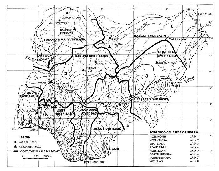
Fig. 1. Hydrological map of Nigeria showing the major inland waters.
Within Nigeria the River Niger is fed by rivers flowing into it from all directions with headwaters originating from the central plateau in the north, from the Yoruba highlands in the south, from Benin Republic to the west and from the eastern highlands. A significant flow from outside Nigeria comes from the watersheds stretching westwards right up to the Fouta Djallon mountains of Guinea. The River Benue is fed by rivers emanating both from the high central plateau and also from the Cameroon mountains and Ogoja hills.
Of the other rivers flowing to the Atlantic, the Cross River is fed by many tributaries originating in the Cameroon mountains. It flows east and then turns southwards and empties into the Atlantic Ocean with limited delta formation. Both the Ogun and Oshun rives are fed by rivers originating from the Yoruba highlands. They flow slowly from north to south into the Lagos lagoons before discharging through creeks and swamps into the Atlantic Ocean. Other rivers flowing into the Atlantic Ocean in the south include; Imo, Kwa Iboe, Ase, Orashi, Benin and numerous creeks in the Delta and Rivers States areas.
Nigeria lies between Longitudes 2° 49'E and 14° 37'E and Latitudes 4° 16'N and 13° 52' North of the Equator. The climate is tropical, characterized by high temperatures and humidity as well as marked wet and dry seasons, though there are variations between South and North. Total rainfall decreases from the coast northwards. The South (below Latitude 8°N) has an annual rainfall ranging between 1,500 and 4,000 mm and the extreme North between 500 and 1000 mm.
Nigeria is blessed with a vast expanse of inland freshwater and brackish ecosystems. Their full extent cannot be accurately stated as it varies with season and from year to year depending on rainfall. However, as shown in Figure 1 these water resources are spread all over the country from the coastal region to the arid zone of the Lake Chad Basin.
The country has an extensive mangrove ecosystem of which a great proportion lies within the Niger Delta and are also found mostly in Rivers, Delta, Cross River, Akwa Ibom, Lagos and Ondo States. They lie between Latitudes 3° and 7° 6' North and are estimated to cover between 500,000 and 885,000 ha. Freshwaters start at the northern limit of the mangrove ecosystems and extend to the Sahelian region.
The approximate extent of the major inland water systems is given in Tables 1 and 2. The major rivers, estimated at about 10,812,400 hectares, make up about 11.5% of the total surface area of Nigeria which is estimated to be approximately 94,185,000 hectares.
Thirteen lakes and reservoirs with a surface area of between 4000 ha and 550,000 ha have a total surface area of 853,600 ha and represent about one percent of the total area of Nigeria.
The water bodies in Table 2 are divided into saline deltas and estuaries, and freshwaters. Deltas and estuaries, with their saline wetlands have a total surface area of 858,000 ha, while freshwaters cover about 3,221,500 ha. Other water bodies, including small reservoirs, fish ponds and miscellaneous wetlands suitable for rice cultivation cover about 4,108,000 ha. Thus the total surface area of water bodies in Nigeria, excluding deltas, estuaries and miscellaneous wetlands suitable for rice cultivation-but not necessarily suitable for fish cultivation, is estimated to be about 14,991,900 ha or 149,919 km2 and constitutes about 15.9% of the total area of Nigeria.
Table 1. Major inland water resources of Nigeria.
Types of water bodies | Approximate surface area (ha) | Reference |
| A: Major Rivers | Ita and Sado et. al. 1985 | |
i) Anambra River | 1,401,000 | |
ii) Benue River | 129,000 | |
iii) Cross River | 3,900,000 | |
iv) Imo River | 910,000 | |
v) Kwa Iboe River | 500,200 | |
vi) Niger River (less Kainji and Jebba lakes) | 169,800 | |
vii) Ogun River | 2,237,000 | |
viii) Oshun River | 1,565,400 | |
| Sub-total | 10,812,400 | |
| B: Major Lakes and Reservoirs | Ita and Sado et. al. 1985 | |
i) Lake Chad (natural) | 550,000 | |
ii) Kainji Lake (man-made) | 127,000 | |
iii) Jebba Lake (man-made) | 35,000 | |
iv) Shiroro Lake (man-made) | 31,200 | |
v) Goronyo Lake (man-made) | 20,000 | |
vi) Tiga Lake (man-made) | 17,800 | |
vii) Chalawa Gorge (man-made) | 10,100 | |
viii) Dadin Kowa (man-made) | 29,000 | |
ix) Kiri (man-made) | 11,500 | |
x) Bakolori (man-made) | 8,000 | |
xi) Lower Anambra (man-made) | 5,000 | |
xii) Zobe (man-made) | 5,000 | |
xiii) Oyan (man-made) | 4,000 | |
| Sub-total | 853,600 | |
| Total A+ B | 11,666,000 | |
| A + B as % of total area of Nigeria (94,185,000ha) | 12.4% |
Table 2. Distribution and extent of Nigerian brackish and fresh waterbodies.
| Types of wetland and distribution | Approximate size (ha) | References |
| 1. Deltas and estuaries | ||
i) Niger delta | 617,000 | Scott (1966) |
ii) Cross River estuary | 95,000 | (1) |
iii) Imo and Qua Iboe estuary | 36,000 | ENPLAN (1974) |
iv) Others | 110,000 | |
| Sub-Total | 858,000 | |
| 2. Freshwaters | ||
i) Niger delta freshwater | 362,000 | Scott (1966) |
ii) Apex of delta to Lokoja | 635,000 | Mutter (1973) |
iii) Niger/Sokoto Basin | 470,000 | Hughes and Hughes (1991) |
iv) Niger Kaduna Basin | 150,000 | Hughes and Hughes (1991) |
v) Lower Niger: Jebba to Lokoja | 385,500 | Hughes and Hughes (1991) |
vi) Benue River floodplain | 312,000 | Hughes and Hughes (1991) |
vii) Hadejia Komadugu Yobe | 624,000 | Hughes and Hughes (1991) |
viii) Ogun/Oshun floodplains | Not estimated | |
ix) Cross River floodplains | 250,000 | Moses (1981) |
x) Imo River floodplains | 26,000 | ENPLAN (1974a) |
xi) Kwa Iboe | 7,000 | Moses (1981) |
| Sub-Total | 3,221,500 | |
| 3. Other freshwaters | ||
i) Minor reservoirs | 98,900 | Ita and Sado et. al. (1985) |
ii) Fish ponds | 5,500 | Ita and Sado et. al. (1985) |
iii) Miscellaneous wetlands suitable for rice cultivation | 4,108,100 | (1) |
| Sub-Total | 4,212,500 | |
| Surface area of Nigeria | 94,185,000 | |
| 1. as % of total area of Nigeria | 1.0% | |
| 2. as % of total area of Nigeria | 3.4% |
![]()
![]()
![]()