The cause and processes of linear erosion
The cause of linear erosion is to be sought in runoff energy, which depends on runoff volume and its squared speed.
THREE THEORIES OF THE ONSET OF RUNOFF
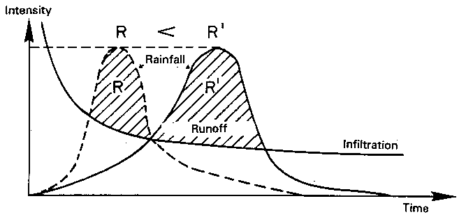
1. Horton's theory (1945). Runoff starts when rainfall intensity exceeds soil absorption capacity (Figure 54a). Comparing infiltration to rainfall intensity, absorption decreases over time partly because capillary potential falls as the wetting front penetrates into the soil, and partly because soil structure at the surface has deteriorated. Rainfall generally has one or several peaks, and any volume of rain over the infiltration curve can be considered runoff. In the example chosen, even at similar intensity peaks runoff volume can vary considerably depending on when peak intensity occurs during the storm. The earlier this peak, the less runoff there will be, since absorption capacity decreases over time. However, hydrologists were unable to obtain any clear correlation between runoff volume for a watershed and rainfall intensity, and so another explanation had to be sought.
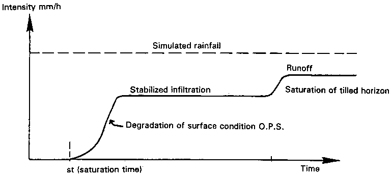
2. Soil saturation theory. Runoff starts when all the pores in the soil are filled with water (Figure 54b). In the course of a simulated rainstorm, if runoff starts after rain has soaked the soil, it will increase until it stabilizes at a level corresponding to the absorption capacity of the soil. However, if the rainfall persists (more than 100 mm), runoff may rise again, reaching a new plateau of stabilized infiltration. This simply means that the tilled horizon has reached saturation, so that the macroporous storage capacity of this horizon is filled to overflowing. If the underlying horizon is totally impervious, the amount of runoff will correspond precisely to that of the simulated rainfall; there may, however, be a certain residual absorption capacity corresponding to that of the plough pan. When the soil is totally saturated, any drop of rain will run off, irrespective of rainfall intensity.
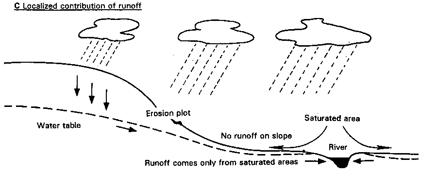
3. Theory of partial watershed surface contribution to runoff. Figure 54c shows that the runoff measured at river-level depends on the area of the saturated soil in the valley bottom. If watershed surface runoff is measured during the dry season, it is seen that the river reacts very quickly to rainstorms whereas no runoff is seen on the slopes! The volume of runoff is less during this dry period because only a narrow strip in the valley bottom is saturated - often only the minor bed. At the end of the winter, however, when the whole soil cover has been soaked to capacity, the slightest rainfall replenishes the aquifer, which will spread out sideways, saturating a greater area of the valley. As a result, even if there is no runoff on the slope during the rainy season, the entire watershed will contribute to the volume of flow in the river through extension of the saturated area, inasmuch as the groundwater is recharged directly by draining the entire basin.
FIGURE
54
Onset of runoff: three
theories
A. If intensity of rainfall > infiltration (Horton)
B. If soil pores are saturated
C. Localized contribution of runoff
Erosion control therefore takes a different form depending on the origin of runoff. If, as in the first case, runoff is a result of degradation of the soil surface, erosion control will primarily entail protecting this soil surface through plant cover, or delaying formation of a slaking crust. If, on the other hand, runoff sets in after saturation of the soil, the first step will be to control drainage. Plants will slow runoff and store it temporarily, thus reducing peak floods and the energy available to carry away solid matter. Lastly, if runoff appears only at specific places in the watershed, there is no point in setting up diversion bunds on the banks of steeper slopes, for very little runoff forms there. This explains the failure of many erosion control projects, which simply apply prescriptions developed in temperate regions under very different environmental conditions (for example, diversion ditches in Sudano-Sahelian areas).
THE PROCESS OF GULLYING
The kinetic energy of raindrops on a slope is more or less constant, depending on the wind-speed. Runoff, on the other hand, tends to accumulate and run together on a longer slope. If the peak flow increases, the soil surface will be cut and a rill will start to form. It will then deepen as the water-borne sediment abrades the bottom of the rill, the edges cave in, and the material thus dislodged is carried away.
V-shaped gullies are the form most common in nature, and tend to be found in relatively loose, homogeneous material - sandy-clay, clay, marl, or schist. The slopes of these gullies alter as the rock weathers: in cold seasons through the alternation of freezing weather and sun, and in hot seasons through the alternation of dry and stormy periods. In Mediterranean areas, weathering can reach 4 to 10 mm per year for marl and schist. Subsidence takes place during exceptional rainstorms. One or two storms per year are enough to carry away all particles accumulated in the gully bottom during the year, and for the solid load in the runoff to abrade the valley bottom.
During intermediate seasons, the fine matter accumulated on the slopes as the rock weathers slides down to the bottom of the gully, partly as a result of the impact of raindrops, partly through formation of small secondary rills, but most often through the mass sloughing of water-saturated particles. Since slope equilibrium has been far exceeded, no vegetation can take root. Erosion control must therefore concentrate on preventing further excavation of the bottom of the gully and re-establishing equilibrium.
U-shaped gullies are a second type common in nature on heterogeneous material. The base may be made up of very resistant material, in which case the channel will broaden as the sides cave in during exceptional flows. If, on the other hand, the resistant layer is found on the surface, runoff will cut deep into the material until it reaches a temporary or permanent water table, which will exercise lateral pressure on the base of the slope until it caves in (undermining the banks). Here again, the gully bottom must be stabilized and the sediment retained until the slopes attain equilibrium. In the agro-industrial farmlands of the Paris basin, there are also "boxed" U-shaped gullies which cut down through increasingly sticky silt from the seed bed down through the tilled horizon and plough pan into the compacted untilled B horizon.
Tunnelling is a third form of gullying, and is still more difficult to treat. It can develop on gentle slopes, in material with surface cracks, on soil rich in swelling clay (vertisols, tropical brown soils, etc.), or on marl rich in gypsum or other soluble minerals (frequent in the Mediterranean basin). During end-of-dry-season rainstorms, the water penetrates these cracked soils down to the weathered rock, percolating through the cracks to the bottom of the slope, where headwater-cutting can form gullies. As hypodermic runoff pours into cracks in the soil, these will gradually become tunnels, which will in due course cave in, forming headward-cutting gullies that can advance by several dozen metres during major rainstorms. Dry tillage is the only way of blocking these cracks and forcing the water to wet the whole soil mass instead of soaking primarily into the megapores.
FACTORS AFFECTING THE VOLUME OF RUNOFF
• Rainfall is the primary element: cumulative rainfall in cases where runoff sets in after saturation of the soil, or the intensity of rainfall over 30 minutes (Wischmeier and Smith 1960, Roose 1973), which is what affects rainsplash and the onset of runoff. On steep slopes in the Andes, the maximal intensity is counted over 15 minutes (Ecuador: De Noni, Viennot and Trujillo 1989).
In Zimbabwe, Hudson claims that rain causes almost no runoff or erosion on very resistant oxisols when rainfall intensity is less than 25 mm per hour. There are therefore intensity thresholds for rainfall below which runoff cannot start on a permeable soil (Casenave and Valentin 1989, Raheliarisoa 1986). Using a rain simulator, Lafforgue and Naah (1976) demonstrated that in the case of a rough soil surface the absorption capacity of the soil increases with any increase in rainfall intensity. On the other hand, if the soil has a finely powdered, smooth surface, an increase in rainfall intensity has no effect on absorption. On fragile, loamy soil, infiltration decreases as rainfall intensity increases, for an almost impermeable slaking crust forms faster (Raheliarisoa 1986).
• Soil moisture content prior to rainfall is the second element affecting the volume of runoff. This factor is expressed either in terms of the lack of soil saturation before the rain (pores not swollen with water), or in terms of the number of hours before it rained, or by use of the Köhler index. The amount of rain absorbed is generally much higher for a dry soil than a moist one: while it may be 10 to 40 mm for dry soil, it will often be only 1 to 10 mm for moist soil. There is an interaction between the condition of the soil structure and initial soil moisture. Boiffin (1976) and Raheliarisoa (1986) demonstrated that simulated rainfall on a dry, loamy soil can degrade the soil surface faster than on already moistened soil.
• The third point affecting the volume of runoff is the size of the catchment area drained by the same channel (Zimbabwe: Stocking 1978).
• The state of the soil surface encompasses:
• soil surface structure;
• cracking;
• holes of biological origin;
• roughness.
Soil roughness mainly influences the amount of rain absorbed before the soil is saturated, but the influence of this factor decreases with steeper gradients, for the volume stored in puddles decreases on steep slopes.
When the soil surface is degraded, clods dissolve, and a thin structural crust forms on their surface, thus reducing infiltration to a few millimetres - or a few dozen millimetres - per hour. However, the sedimentation crusts that spread over the area, starting with the puddles between the clods, can be as thick as several centimetres and have extremely low infiltration capacity: from 0 to 10 mm/in. Runoff on a given plot will thus depend on the area covered by the various types of crust, and by the macropores that remain open between the clods on the soil surface.
• The gradient of the slope. This generally reduces the volume of runoff, for on a steep slope internal drainage is better, and a slaking crust forms more slowly as it is continually destroyed by runoff energy. The length of the slope also affects the volume of runoff, but although this volume, expressed as a percentage, theoretically remains constant all the way down the slope, in many instances of bare soil it seems that the runoff coefficient decreases as the slope lengthens (Roose 1973, Valentin 1978).
• Cropping techniques can increase absorption to a considerable degree. At Pouni in Burkina Faso, absorption on a bare, untilled soil was compared with that on the same soil when crop residues were dug in or when it was treated with tied ridging. Absorption of a 120-millimetre rainstorm rises from 35 mm to over 104. Also of interest here are French trials in the Pas de Calais region measuring the effect of the number of passes of farm implements over the land.
• The effect of mesofauna at Saria in Burkina Faso should also be highlighted. The final infiltration of a 100 mm sheet of water over 100 cm² was measured. Absorption was between 5 and 12 mm/in on crusted bare soil, about 60 mm/in where there were termite holes, as much as 90 mm/in after the slaking crust was removed, and finally 120 mm/in after the soil was dug to a depth of 5 cm. Holes made by earthworms, and in some cases termites, can have a considerable effect on infiltration, inasmuch as the flow in a tube varies to the fifth power of the diameter of the tube. The flow in a 2/mm pore will be 32 times greater than in a 1-mm pore. And the tunnels left by earthworms and termites are often over 4 mm in diameter.
FACTORS AFFECTING FLOW VELOCITY
The second factor that can help to reduce or increase the kinetic energy of runoff is its velocity.
• Runoff velocity depends on the depth of the runoff sheet and the slope and roughness of the channel. The slope increases the speed of flow and hence the advance of gullying, although gullying can very easily start on slopes of less than 1%.
• The topographical position of the plot can also be a major factor (Heusch 1970): water can drain away in the soil until it reaches the valley bottom, but gullying can develop where the groundwater emerges, later leading to headward erosion.
• Differences in height will also influence the depth of gullies: the height from which water falls into the gully causes a considerable vortex energy, which will accelerate erosion or the speed at which gully-heads advance. Stocking's studies on the speed at which gullies advance in Zimbabwe should also be mentioned here. Having studied different types of gully on homogeneous soils, he observes that whatever the type of gully, erosion depends on:
• the volume of rainfall, i.e. r in mm;
• the surface area of the catchment in km², and hence the volume of runoff;
• the height of the fall at the head of the gully (h).
The equation is as follows:
Gully erosion = 6.87 × 10⁻³ r1.34 × s1 × h0.52
• Plant cover has a complex influence on linear erosion:
• plant cover protects against the impact of rainsplash, hence prolonging soil permeability and reducing the volume of runoff;
• its litter attracts mesofauna (which dig out macropores) and absorbs a considerable quantity of runoff energy;
• the roughness of the soil depends on the number of stalks per square metre, so that a plant cover made up of grasses with many stalks is more effective than trees in protecting the soil against runoff.
• The soil itself affects runoff and erosion in various ways. Thus, the roughness of the soil surface slows down runoff and also affects the volume stored, while the stability of the soil structure affects the velocity of rainsplash and hence the amount of the rain absorbed before runoff starts. If the soil surface contains gravel or larger stones, there can be two opposite effects (Poesen 1989; Valentin and Figueroa 1987): if such stones are on the soil surface, they protect it against splash and also protect the underlying macroporosity, and hence have a positive effect on infiltration. On the other hand, if the stones are included in the sedimentation or slaking crusts, runoff will increase. If soils are compacted, they will be less pervious but more cohesive, and therefore more resistant to runoff. If the soil profile is homogeneous, erosion will produce a V-shaped gully, whereas if soil resistance is irregular, a U-shaped gully with vertical sides will form because erosion velocity depends on how well the material resists cutting.
In 1935 Hjulström studied soil erodibility as a function of soil texture and flow velocity, in canals. In a graph (Figure 19, page 92) showing flow velocity as a function of particle size, Hjulström demonstrated three levels: an upper erosion level, with a minimum of about 100 microns, a lower sedimentation level, and between the two a transport level. Erosion starts at a minimum flow velocity of 25 cm per second and with the texture of the bank soil at about 100 microns, i.e., the size of fine sand, which is lighter than coarse sand and gravel and less cohesive than loam and clay. The minimum flow velocity for erosion is roughly 25 cm/s. It therefore appears that the most vulnerable matter - fine sand in this case - is slightly coarser than in sheet erosion, where the most vulnerable matter is 10-100 m (Wischmeier, Johnson and Cross 1971). This is why sheet runoff moving at under 25 cm/s carries away only fine particles and light particles detached by rainsplash, and not coarse sand. On the other hand, where runoff is concentrated, erosion is no longer selective and the speed and energy of the flow increase, digging out rills. When the slope gets steeper, runoff energy increases and exceeds that of sheet erosion. Energy becomes channelled toward the formation of rills and gullies, scouring the topsoil and draining all loose material across the breadth of the slope along these lines.
A further observation is that the transport area in sandy textures is very narrow, so that the shift from the erosion to the sedimentation level occurs as soon as runoff speed falls: hence the sandy deposits that very often litter channels - for example diversion ditches, particularly at the end of each spate. This is particularly striking in the case of rivers in the Sudano-Sahelian area of Cameroon, the beds of which are littered with coarse sand.
Controlling runoff and linear erosion
This entails cutting runoff velocity and gradually reducing the volume of runoff.
ON FIELDS
The volume of runoff leaving a field can be reduced by adjusting cropping techniques and plant cover. Deep tillage allows better root growth, better water storage in subsurface horizons, and hence better development of plant cover, significantly reducing erosion and runoff. Another and opposite technique is never to leave the soil surface bare, till it as little as possible, and only along the seed line. Here again water is absorbed through the macropores created by mesofauna, and the level of erosion is very low. Where there are earthworms and termites, they will consume the litter deposited on the soil surface, dig out macropores, and maintain optimum absorption.
IN DRY VALLEYS
In dry valleys, small gullies and the bottoms of drained valleys, it is often enough simply not to till the soil or to keep compacted land under grassland to reduce erosion damage. Living obstacles such as hedges or dead obstacles such as bales of straw can also be set up in a V formation across such valleys. Another, but more expensive, solution consists of digging out storm ponds or building small earth dams to reduce flood flows and trap the suspended solid load in order to prevent mudflows from damaging inhabited areas. However, the expense of this method should be considered, for it immobilizes land and requires regular channel clearance.
BIOLOGICAL FIXATION OF SMALL GULLIES (cf. Lilin and Koohafkan 1987)
Small gully erosion varies considerably from one region to another depending on the extent of degradation. If woody vegetation still constitutes a protective armour for the valley bottom but is showing signs of weakness in some places, more attention should simply be given to preventive measures, and agricultural development curtailed in the bottom. Once the gully has started to cut into the bottom, the broken balance will need to be restored.
There are two distinct aims of this type of intervention.
The main objective will generally be that of improving farm or forest productivity by exploiting the alluvium that builds up behind each sill in the gully bottom. Since torrent phenomena are almost negligible, these deposits often have a high productive potential. As soil collects above the sill, fruit trees (for example: in Haiti - breadfruit, mango, coconut, banana; in Algeria - pear, apple, apricot, walnut, or poplar, ash, etc.) or water-demanding food crops can be planted.
The second objective is that of reducing the solid load and regulating flows. This aspect especially concerns sectors downstream of the area treated. Mindful of environmental conditions and the plant material available, the biological treatment of small gullies should be stressed. The basic instrument is a sill crosswise to the gully made up of living plants. This approach is based on the technique of hedges of large, close-planted cuttings used by peasant farmers to fence farm plots and protect them from livestock. The technique is widely used in Haiti, Rwanda and Burundi and is easy for farmers to learn, although it requires adaptation to the specific problems of gully treatment.
Various types of plant material are used in building a sill: large cuttings of woody species, and plants such as sisal and grasses to break the flow of the water and protect the lower side of the construction from undermining. Species must be chosen on the basis of their suitability for gully treatment: resistance to very swift-flowing water, jolting, bark-stripping, undermining and submersion; and a swift growth-rate. Euphorbia lactea, various sisals, Bromelia, Glyciridia septium, yucca, Bambusa vulgaris, guava, Jatropha curcas, Cassia and Leucaena leucocephala can be used in Haiti. However, this list of useful plants should be adapted for each region. The conditions each requires, as well as production methods for fragments or cuttings and rooted plants, will need to be spelled out.
After a hedge has been planted across the bed, a filter to induce deposit of the sediment load is formed by branches laid against the hedge. The height of this filter must be raised as the alluvial deposit and hedge grow in height. In Haiti, it is best to use cuttings between 1.2 and 1.5 metres high, 50 cm of which are below ground to stabilize the sills. In favourable conditions, the cuttings making up the sill can be planted directly across the bed without further care, in fairly close single or double lines with about 30 cm between cuttings. In some cases, recovery of the active gully-bed must start from the two banks - particularly when the colluvium is regularly swept away by floods as spring tides uproot plants during peak flows. Under these conditions, it may be possible to reestablish vegetation in the gully by using the trees growing on the two banks, for example by bending a slip down from either bank and attaching earth-filled woven baskets or old tyres in which cuttings have been planted. This favours the establishment of vegetation.
When gullying is already too far advanced, the technique is to build a small dry-stone sill before planting woody shrubs. As the sill silts up, it creates a favourable environment for the establishment of plants. It also spreads the sheet of water flowing down the gully during peak floods, thus helping to prevent the plant sill from being swept away. Where few stones are available, they can be replaced by earth-filled salvage bags, protected by a thin layer of gravel or cement, or simply earth - especially for plastic bags that disintegrate faster when exposed to the sun's rays. These barriers made of stones or bags of earth have a temporary role, with the biological barrier then taking over in order to control gullying. They need not be very high - 50 to 100 cm at the notch should be adequate - but they must be V-shaped so as to concentrate the flow down the stream of the gully.
Once these small structures are built they must be properly maintained:
• repair of weak points in the sill with supplementary planting;
• addition of a filter of plant residues;
• making sure that the water cannot flow around the barrier, by planting protective vegetation along the banks, reinforcing this if need be with branches;
• prevention of undermining below the barrier by limiting its height and planting certain species immediately below it: agave and fast-growing forage plants.
Generally speaking, government officers cannot be responsible for such upkeep. The farmers can be expected to assume this responsibility if the barriers have a great enough effect on farm productivity in the gully bottom. The distance between such correction sills in a small gully does not need to be calculated as precisely as for large, torrential gullies: alluvium is usually shallower, so that any localized cutting due to destruction of a sill develops more slowly into headward erosion than it does in the presence of deep alluvium in larger gullies. The authors of treatment projects therefore have a certain flexibility in the positioning of sills, which means that they can start the treatment where there are no land tenure problems, or where the landowners on the gully banks are willing to work together. In principle, priority should be given to the upstream sections, where the chances of success are higher as torrentiality is less. Once these sections have been treated, it will also be easier to treat the lower sections.
The second priority is that of treating gully sections that can lead to more appreciable results, for example a topographical situation allowing creation of a large alluvial deposit with a similar type of construction, proximity to the village and good access, thus facilitating surveillance and the removal of harvests.
LARGE, TORRENTIAL GULLIES (Lilin and Koohafkan 1987)
In large, torrential gullies, torrent-correction dams are the developer's basic instrument. Such treatment can have two objectives:
1. Stabilizing the length-wise profile of the gully in sections where there is a general tendency to cutting. The constructions primarily hold back the part of the hillside that would gradually be carried down into the gully (through undermining of banks and sliding) if the cutting continued; in other words, they stop headward erosion. The objective here is therefore not to hold back a great deal of sediment, but to prevent the gully from deepening.
2. Holding back sediment in transit sections where there is little cutting. Here retention becomes the main purpose, rather than a by-product as in the first case. Storage of alluvium (a) helps to prevent silting-up in dams further downstream, (b) improves water resources by spreading floods and storing ground water in the alluvium thus collected, and (c) protects inhabited areas against torrential wash.
The general principles to be observed in treating large gullies are as follows:
• The dams must have a long life-span, since plants cannot be expected to take over at once. They will be built in resistant materials - gabions, but especially masonry dams of large stones and cement.
• Plants play a major role even if the dams are the central element in this treatment. Establishment of vegetation on the alluvial deposits (except in the central part of the channel, which is left free to facilitate flow):
• consolidates siltation, or the accumulation of sediment in the channel, and allows steeper slopes, which in turn means that more such matter can be stored;
• channels and recentres flows, so that banks are not undermined and water does not flow around the structure;
• produces wood, forage or fruit, depending on the choice of species used, in a place made unsuitable for annual crops by torrentiality.
• The structures must backstop one another, with spacing calculated on the basis of the equilibrium bed slope, i.e., the slope point at the gully bottom at which there is neither removal nor sedimentation. The principle of stepped torrent control must be respected if the intervention is to be lasting. Excessive spacing or the destruction of one structure will compromise the long-term stability of all the structures above, for headward erosion is particularly rapid when a mass of alluvium carpets the gully bed. Even when such erosion is slower because it has to cut through rock, calculations must be based on the long term, bearing in mind the intended sustainability.
Where spacing between structures is too great, the dam base is undermined and the cost of repair operations high (underpinning of the stonework, building an auxiliary dam). It is therefore better economics to space dams so as to minimize the risk of undermining.
When the aim is that of stabilizing the profile, the sections where cutting is important must be treated. Modest-sized structures are often enough to halt cutting. When the aim is that of trapping and storing sediment, operations are usually concentrated lower down, on more gently sloping sections, so that a greater volume of sediment can be trapped for a dam of the same height although this second objective does also mean increased dam height.
The torrent control works described represent a technique that is both expensive and fragile. The high cost is due to the use of durable materials (gabions and stonework) and the need to build structures sturdy and large enough to withstand the various constraints and risks (jolts from boulders, shearing of unstable banks, overturning under the pressure of water, undermining, piping erosion, circumvention, etc.).
The fragility stems from the fact that destruction of one structure often leads to the destruction of those upstream as a result of headward erosion. Such treatment of a large gully is financially justified only if major economic interests are at stake and there is a sufficiently well-funded, well-staffed unit responsible for ensuring maintenance.
TREATMENT OF MEDIUM-SIZED GULLIES THROUGH MECHANICAL AND BIOLOGICAL ENGINEERING (Lilin and Koohafkan 1987)
When small gullies have deteriorated to the point where direct biological barriers are no longer feasible, but before the torrential gullying stage, biological action can be taken only after the gully-bottom has been stabilized by building sills.
The various principles for treatment of medium-sized gullies are given in the "Ten Commandments for Gully Treatment" (page 216). Since the sills do not have an indefinite life-span, a saving can be made on dry stone barriers where stones are scarce, and on gabions where these are still too expensive, by replacing them with sills in metal fencing, which generally cost about one-third as much. The successive establishment of vegetation is what, in the end, definitely stabilizes the gully. The first point is to fix sediment as soon as it is deposited, by planting rhizome grasses which will continue to grow as the sediment piles up, while unbroken, closely-planted lines of shrubs on the sides of the gully will help to recentre the flow. Then, when enough soil has collected, large fodder, fruit or high-value timber trees can be planted along the gully to stabilize the slopes. Research should be done to find the most suitable and productive species for the sides of the gully. A line of trees along the edge of the gully can also help to isolate this microenvironment, which is still fragile.
For small and medium-sized gullies, the use of plants attractive to farmers can also be fostered. The farmers can then be trained to maintain this system of gully fixing and control while at the same time producing forage, fruit and wood.
In Algeria, for example, the life-span of dams is very short - between two and ten years for small earth dams, and twenty to fifty years for large dams. Action therefore focused on rehabilitation of mountainous land and gully control (Figure 55). The general aim is that of stopping erosion, in other words blocking the process of gullying. Low dams are built in deep, narrow bottlenecks where raised sills then form. These can be gradually raised to the point where the slope and the banks reach equilibrium. It is a question of managing sediment. However, since treatment of a medium-sized gully 1 km long costs between 100000 and 500000 FF (US$ 20000 and 100000) and there are tens of thousands of gullies requiring treatment, feasibility studies are being done to reduce the cost and to make intervention more cost-effective (Roose 1989, Bourougaa and Monjengue 1989). At present, gabions are being built at the mouths of secondary gullies where they flow into main gullies, while the whole length of these secondary gullies can then be stabilized through use of sills made of lightweight wire mesh.