A VARIETY OF NATURAL ENVIRONMENTS
This variety springs from the interaction of several factors, the most important of which are the nature of the soils, the bioclimate and the topography.
Four major agro-environmental units (Figure 76) have been identified, with various sub-units. These distinctions are fundamental to any understanding of the choices made by farmers regarding crop distribution and land use on each plot. They are as follows:
Unit 1: high bluffs and calcareous uplands. Between 500 and 900 m in altitude, they have ferralitic soil on the higher reaches, and calcimagnesic soil lower down. They are stony, and organic fertility is poor. Rainfall is frequent and sometimes heavy (60 to 88 mm/h). Winds can be violent and constitute an additional crop constraint. The basic crop combination is maize-beans-sweet potato, with the occasional addition of cabbage and yam. This is the most deforested zone on the transect except for areas that are densely populated thanks to the presence of gardens, always owned outright, around the home: the devant porte kaye garden, also known as the lakou.
Unit 2: marly-calcareous hillslopes and bottom lands. This is an area where springs emerge, and where the soils are more favourable to permanent crops (vertisols, brown calcareous soils). Rainfall is heavy enough to allow two cropping seasons, mainly yam, maize, sorghum and black beans. Banana, coffee and malanga (Xanthosoma spp.) are also found in the cooler spots (gullies, bottoms). Forest cover is extensive, with a preponderance of breadfruit (Artocarpus incisa non-semifera variety).
FIGURE 76 Agro-environmental cross-section of the transect
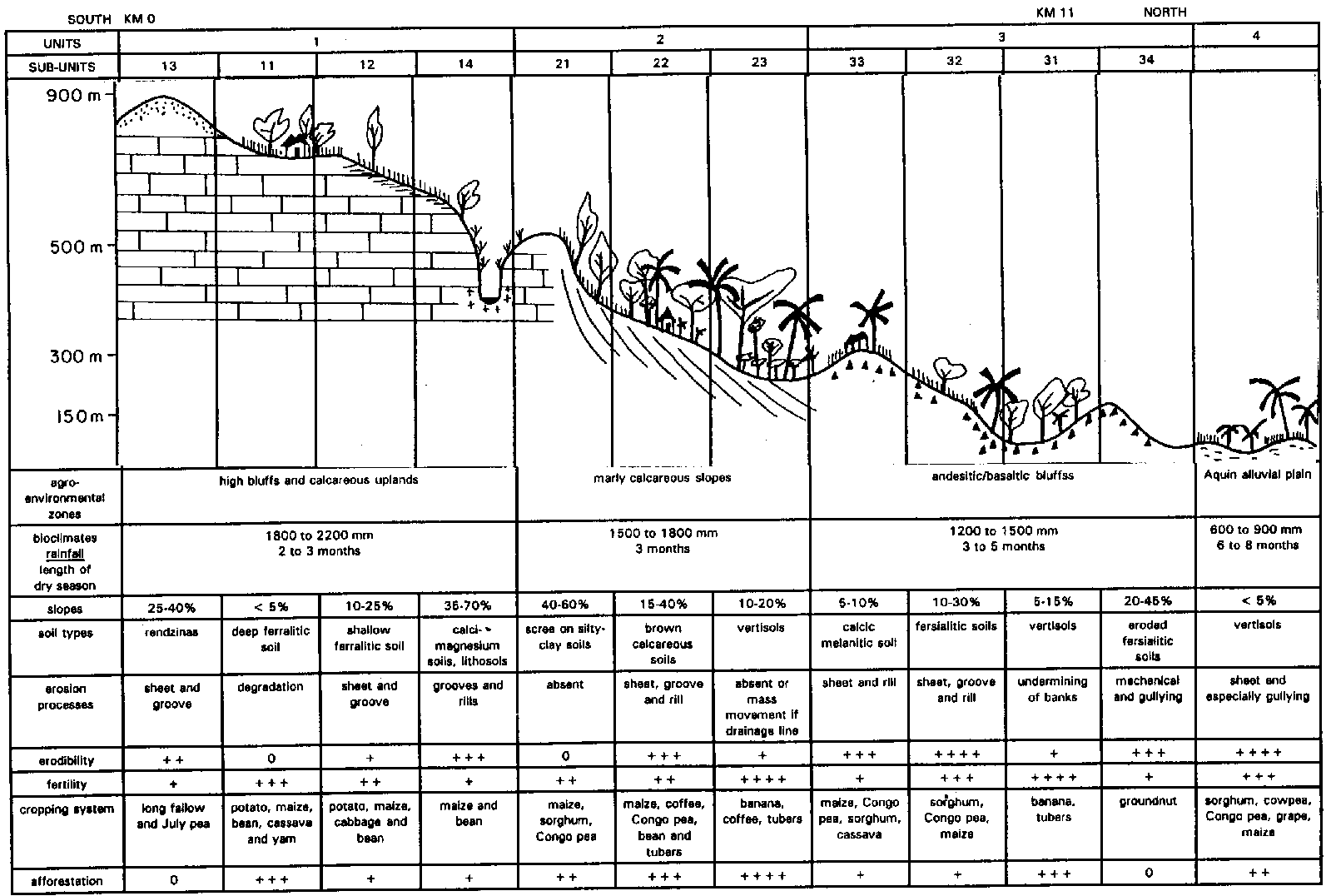
Unit 3: andesitic or basaltic bluffs. This unit is less well-watered (1200 mm/yr) and below 300 m in altitude. A fairly marked dry season makes only one cropping season possible: sorghum, groundnut, Congo pea, and sometimes maize. The soils of volcanic origin are very well-suited to agriculture; however, they are often found on slopes, exposing them to strong sheet erosion from diffuse runoff or groove and rill erosion.
Unit 4: the Aquin plain. This lies between sea level and 300 m. The climate is dry tropical, with a mean annual rainfall of 600-1000 mm with considerable yearly variation and a dry season of six to eight months. The soils are vertisols, with little infiltration on gentle slopes (3 to 10%). Cropping systems concentrate on various combinations: maize, cowpea, sorghum, Congo pea, vigna. Gullying is frequent at points where rainwater concentrates (roads and paths).
A VARIETY OF PRODUCTION SYSTEMS
Several factors account for this diversity:
• unequal pressure on landowning;
• complex types of land tenure, the four major types being (in decreasing order of security): land ownership with formally divided inherited land, informally divided inherited land or jointly owned inherited land; to which should be added types of land use: owner-operated (the most common), tenancy ($60 to $120/ha/yr), and sharecropping (one-third to one-half share handed to the owner), the system in use among the poorest;
• the available human resources, whether sold or bought;
• the availability of livestock resources.
These internal factors give rise to three major farming systems, corresponding to a variety of socio-economic levels:
• Low: farmers owning very little land (less than 1 ha), tending to share-crop, with very meagre capital resources and reduced livestock resources, and who very often have to sell their labour to augment their income. For some this is simply the way they start off in farming, but for others it is a permanent condition, the main cause being land rentals that obviate savings.
• Medium: there is enough arable land (1 to 3 ha) to feed the whole family, making the head of the household less dependent on rich farmers and the market, but also less integrated with the latter. Accumulation is based on farm production, and can be slowed down by the growth of the family. Farming swings between the two extremes, keeping a dynamic balance.
• High: arable land (more than 3 ha) allows production in excess of family needs, and there is enough livestock to function as productive savings. The accumulation processes usually start with a large inheritance and/or a second activity (carpentry, bricklaying, etc.). These farms draw on a significant labour pool, and quickly increase their capital.
These differences in farming systems explain the different ways in which natural resources are managed, and the different degrees of their degradation, and also why strategies for maintaining fertility will be different. For example, the density of livestock per hectare on farms with little land will tend to lead to compaction of soil, then runoff and finally erosion; selling one's labour or working on land with insecure tenure does not encourage a maximum investment of labour or inspire people to protect the cultivated area. Jointly owned land shows advanced degradation: severe compaction, outcrops of mother-rock, no trees, very poor fertility.
A VARIETY OF DEGRADATION PROCESSES
The range of factors mentioned above (agro-environmental conditions and farming systems) also explains the variety in processes of soil-cover degradation, which happens in three stages:
• constant, rapid mineralization of organic matter, not compensated for after clearing (little or no organic matter dug in) and hastened by (selective) erosion;
• gradual slipping of surface layers through repeated tilling of soil under foodcrops that are not long in the ground (on slopes the soil is always tilled downhill);
• onset of runoff and gullying following compaction of the soil by tethered livestock and on paths, especially following reduction in the water storage capacity of soil scoured by dry mechanical (man-made) erosion; in areas with calcareous substrata the saturation point is reached after 70 to 80 mm of rainfall on deep ferralitic soil and less than 30 mm on worn-out land or rendzinas; and rainstorms of more than 60 to 80 mm/in occur three to six times every year, plus hurricanes every four to ten years, with more than 400 mm of rain in five days.
Sheet erosion seems insignificant in Unit 1: true slaking crusts are rarely seen, but there are frequent aggregate discharges, as well as disintegration of mounds and compaction of the soil surface. Clayey, well-structured, chalky and pebbly soils are very resistant: rainsplash dislodges aggregates.
Linear erosion is seen everywhere in the form of grooves (channels of several centimetres) (Unit 1) and rills (tens of centimetres), quickly developing into active gullies (metres) (Units 2, 3, 4) if nothing is done to stop it. Land where there are outcrops of mother-rock ("worn-out land"), tracks and paths, overgrazed fallows and vertisols on basalt are the source of dangerous runoff on steep slopes. Impermeable brown soils on basalt give copious runoff (Pi = 2 to 5 mm with moisture).
Mass movement takes the form of creep and dry mechanical erosion due to tilling on steep slopes, and through headward cutting starting from the network of gullies on convex slopes (especially Unit 3).
Erosion of banks is very widespread in the plains, where rivers carrying excess sediment loads (Unit 4) frequently alter channel.
Generally speaking, erosion is more significant on basaltic or andesitic than calcareous soil, although economic effects vary according to the nature of the subsoil. Thus, on a basaltic or andesitic substratum there is a high rate of weathering of mother-rock and pedogenesis is quite fast, so that there are fairly good possibilities of restoring fertility following degradation. However pedogenesis is much slower on calcareous substratum, and once the soil capital has been depleted there is much less possibility.
Farmers' traditional strategies and their limitations
In these very varied conditions, farmers choose, combine and apportion plant species by area and season. Cropping patterns are thus the outcome of reasoned choices and indicate how far farmers have adapted to local conditions. For all that, there is not necessarily a proper balance, and there are certain worrying developments that could end in failure.
COMBATING DEGRADATION: A FARMER'S WAY OF MANAGING FERTILITY
The three Haitian gardens: improving fertility or increasing soil degradation by transferring crop residues?
Fertility in the three gardens involves livestock-based transfers.
Each farm in Unit 1 comprises at least the following three gardens:
• The devant porte kaye garden (A), also called lakou (500 to 1000 m²): this is an area of dense vegetation surrounding the house, and is always owned by the householder. Many perennial or annual species are grown in combination here, forming several storeys: avocado (Persea americana), chadequier (Citrus maxima), banana, coffee, malanga (Xanthosoma campestris), taro (Colocacia esculenta), yam (Discorea sp.), chayote or christophene (Sechia edulis), pumpkin (Cucurbita moschata), chives (Allium fostulosum).
• The pré-kaye garden (B) (1000 to 5000 m²): this treeless area is bounded by a shrub hedge to mark off the property and protect crops from wind and animals. Beans, maize, yams, sweet potato (Ipomea batata) and cassava (Manihot utilissima) are grown here in combination.
• The loin kaye garden (C), often with a total area of over 5000 m²: this garden is found in areas with very few trees and far from dwellings. It may be rented, share-cropped or jointly owned. Fertility is low and soil is degraded. Farmers intercrop beans and sweet potato for six months, after which the plot is left as grassland. If the garden is extremely degraded and situated on a steep slope (D), it is left fallow for long periods (more than three years) as goat pasture (racks zone).
Farms in Unit 2 differ in various ways from those in Unit 1. The considerable tree cover in these zones makes it hard to distinguish between A and B gardens, so that both could be lumped together as a single A garden. However, there is a new type of garden here that the farmers call a "field" and is comprised basically of banana (sometimes combined with malanga) under tree cover. These gardens are not always found near dwellings, and their location depends on the availability of water and the coolness of the soil, i.e., in the bottom lands or near spring lines.
FIGURE 77 Types of garden, fertility transferral and tree cover (cf. Guarrigue 1990)
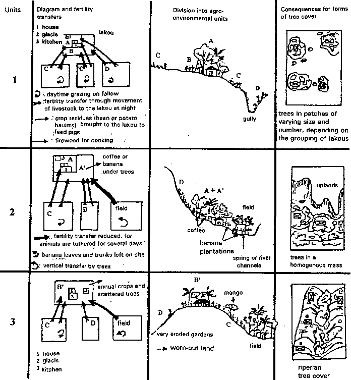
In Unit 3 there is still the garden near the house, in a space protected and bounded by a continuous hedge, situated on dry bluffs, although it tends to become poorer at lower altitudes, sometimes whittled down to a few trees scattered around the house (coconut, mango); in short, gardens A and B tend to become a single, lightly, wooded, B-type garden. There are also perennial bottomland gardens, heavily wooded and very fertile, which can be classified as A gardens growing in wetter areas.
This garden structure disappears in Unit 4.
Arguably, the distribution of the different types of garden is mainly determined in Unit 1 by the distance of plots from dwellings, and in Units 2 and 3 by soil type (lowlands = alluvial and colluvial deposits) and humidity.
It is important to note that farmers transfer crop residues from one plot to another in order to manage reserves of organic matter (Figure 77). However, while fertility increases in certain gardens (usually the freehold ones) near the dwellings, this is at the expense of other plots (usually sharecropped or rented) further away, where fertility drops because crop residues are regularly used on plots with more secure tenure. Farmers have little interest in fertilizing these more distant plots when they do not know if they will be able to use them the following year. The land tenure factor is pivotal to soil degradation.
THE USE OF FALLOWS
Fallows used to be common in Haiti, but are tending to disappear. Fallow periods can last from three months to two years depending on the type of garden and the land available to the farmer.
In Unit 1, the poorer land furthest from the home is left fallow for one or two years after a cropping cycle of one or two years. On the most fertile land closest to the home, the fallow lasts only two to six months - the time needed to fertilize the plot by keeping animals on it who are fed fodder. In the first case, the land is "rested." The second is in fact a fertilization technique.
In Unit 3, intercropping (maize, sorghum, Congo pea) fill the plot throughout most of the year (April to January) and then preparation of the soil starts with the first rains (March/April). Fallows are infrequent and only at long intervals. Soil fertility depends solely on the effectiveness of intercropping, for there is no mineral fertilization. The farmer will always give economic reasons (no seed, insufficient labour available, etc.) for not cultivating a plot, rather than reasons connected with preserving fertility.
Conclusions. When fallow periods are long (one to two years), livestock is left tethered without fodder, initially to eat harvest residues on the spot (maize or sorghum stubble, or potato haulms), and then to graze. This gives an on-site recycling of organic matter from animal dung which, being unfermented, loses much nitrogen in the sun. This technique often leads to compaction of the soil on steep slopes, encouraging runoff.
CONCENTRATING ORGANIC MATTER WITHIN MOUNDS
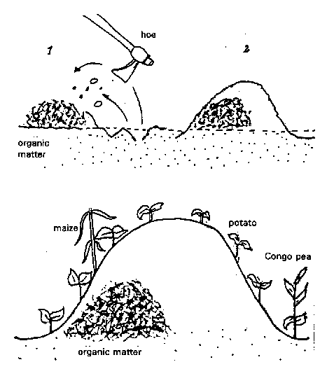
This practice is followed on all types of garden (Figure 78). After a fallow period, and one month before sowing and planting, weeds are hoed, dried and piled up. They are then covered with earth from the surface horizon (15 cm), which is the richest in organic matter, to form mounds about 1 metre in diameter. This procedure assists root growth by improving drainage and aeration, but, more importantly, it allows a concentration of organic matter within the mound. As the most demanding plant, maize is sown in the most favourable location, while Congo pea - less demanding because of its deep, powerful root system - is sown in the least favourable location.
FIGURE 78 Preparing a compost mound (cf. GRET/FAMV 1991)
BURNING
This practice is common in Units 3 and 4 where the residual plant material is very woody sorghum stubble, Congo pea or cassava stalks - and is burnt when there is enough of it, since it would decompose too slowly otherwise. Although such burning allows rapid preparation of the ground and also releases a large number of mineral elements, making them available quickly at the start of the growing season, there are some drawbacks: it encourages runoff and scouring on steep slopes, and does not allow enhanced water retention or enrichment with organic matter by digging in. If the slopes have good organic matter content, there is less degradation, but sheet erosion is still significant.
COMBATING SHEET EROSION
Sheet erosion occurs in Units 2 and 3 on slopes, and in Unit 1 on degraded soil on steep slopes.
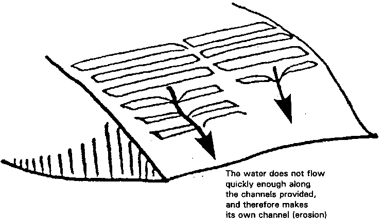
FIGURE 79 Effect of overly long ridges (cf. Smolikowski 1989)
The farmers use traditional control measures, but these are limited in effect - although they do have the advantage of being integrated into the farming system and could therefore be improved.
• Horizontal ridges (Figure 79) on a slope are not enough to stem erosion. They have only a limited effect on runoff, and rarely follow contour lines. And when they are too long, water collects at certain points, the ridges give way, and linear erosion starts with heavy rainstorms.
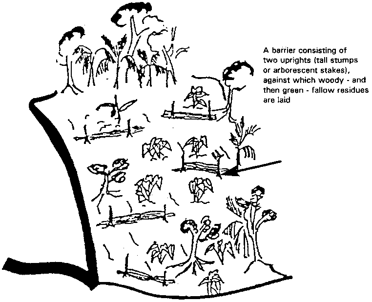
• Straw barriers are widely used, but to little effect. These small barriers (Figure 80) are made by sticking two wooden posts into the ground, then laying other woody residues between them, interwoven with green fallow residue after clearing. These structures are not permanent and can have no cumulative effect over the years. Moreover, they are only roughly horizontal, and are too permeable.
• Hedges of various species could have some degree of effectiveness. Unfortunately, they are found only on plots near dwellings (A- and B-type gardens), i.e., on gentle slopes on freehold land. Furthermore, they are planted chiefly as enclosures and not along the contour lines, with the main purpose of protecting against theft and preventing animals from straying. The species used are not attractive to livestock and produce little biomass. Here too, such investments are made on land with the most secure tenure.
COMBATING LINEAR EROSION
Farmers also use wattle barriers to prevent rills or grooves, but this is less common, since these forms of erosion appear mostly in Units 3 and 4 where vegetation is sparser.
FIGURE 80 System of straw barriers (cf. Smolikowski 1989)
For small and medium gullies, farmers build small sills of plant material or stones, but this not-very-common practice requires care and upkeep, since the structures are often fragile and can be swept away in heavy rain.
COMBATING MASS MOVEMENT
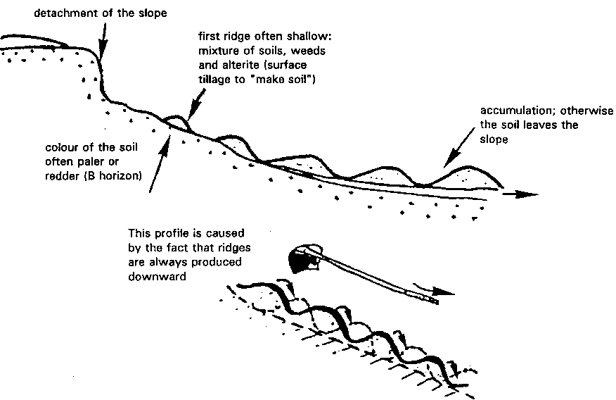
There is no traditional technique for combating this form of erosion. Moreover, such phenomena are often hastened by the way that farmers till slopes: each year they work from top to bottom as they prepare mounds or ridges, so that a portion of the soil is moved downhill (Figure 81). This amounts to a gradual sliding of the surface layer material.
ONE WAY OF MANAGING BIOMASS: WOODED GARDENS
The existence of a tree strata in the various gardens and their distribution in the different environmental units has already been mentioned (Figure 77). Despite what people say, trees always play an important role in Haitian farming. This role may expand or contract according to circumstances, but management of trees is closely tied to the production factors of the farming system concerned (land tenure, income level, method of stock rearing, form of inheritance,1 etc.).
1
Usually, when a farming couple dies, the pré-kaye garden will be kept and divided into a number of A-type gardens, or destroyed (trees felled, crops divided) and abandoned. Since the number of heirs makes it impossible to share out the inheritance equitably, the land becomes jointly owned.
FIGURE 81 Man-made erosion: tilling the soil on a slope (cf. Smolikowski 1989)
Haitian farmers are aware of the environmental role of wooded spaces (better infiltration of rainwater, biomass production, reduction in the effects of rainsplash and in mass movement). However, outside factors (pressure on land and low incomes that tend to favour the sale of charcoal) and other implicit farming constraints often make it hard for them to preserve this heritage.
Moreover, the traditional tethered system of animal husbandry precludes planted trees. The role of livestock in savings and in income-producing gives animals priority over trees. Growing trees or shrubs requires a major change in methods of animal husbandry.
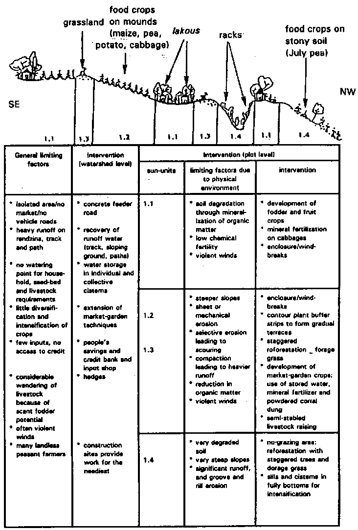
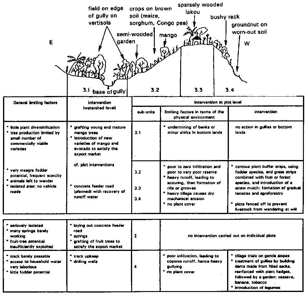
FIGURE 82
Types of erosion control and main actions in the agro-environmental sub-units of the transect
SE - NW
E - W
All these traditional erosion control techniques confirm that Haitian farmers are the shapers of the agrarian landscape. However, despite their remarkable adaptability, the whole approach to production and the dynamics of rural Haitian society admittedly lead to breaking points which could compromise the sustainability of certain systems. The main causes include the following:
• a very restrictive agrarian space, exposed to all types of erosion;
• land tenure problems that hamper co-ordinated control structures on a plot or slope and also encourage erosion;
• abrupt changes in techniques as a result of economic breakdowns (the coffee market) forcing farmers to introduce new crops or at least grow them on a new, more intensive scale, and so hasten the process of degradation (clearing and weeded crops);
• intensification prevents renewal of stock of organic matter and replacement is insufficient; tillage also accelerates sliding of the soil cover, so that in a few years (six to eight) "mixed" land can turn into "worn-out" land.
Conclusions. The farmers' traditional techniques for managing water and soil fertility and also their tillage techniques - must be reinforced, in order to improve management of surface water, increase organic (then mineral) inputs, and improve plant cover by encouraging the use of enclosures.