


Historical mapping is used to:
stimulate discussion of why and how a problem arose;
gain community insight into the "root" of a problem.
Understanding the origin of a problem can provide the project and the community with a clean slate on which to start building solutions.
This tool assists in documenting, either in pictures, writing or symbols, the history of the community or beneficiary group. A timetable (either every five or ten years) is established, going back as far as people can remember. The timetable is focused on a specific subject such as natural or communal resource management or village growth and its effect on the surrounding environment.
Time: minimal. Group meeting.
Expense: minimal. Materials on which to write (draw) the time line.
Training: minimal. Can be facilitated by anyone experienced in two-way communication.
1. Create a time line to follow - every five or ten years, with events to be filled in through group discussion.
2. Allow time for discussion around each time period, make sure that all relevant events are recorded.
Sensitive issues from the past may be raised. If this happens, the facilitator can move to the next time period and return to the sensitive issue later on. The group should not get stuck in deep discussion of each issue.
A community in Asia produced this time line in one meeting. They later developed it in picture form.
1930 Extensive forest felling for Rana Palace
1940 First recruitment to British army from village
1945 Extensive felling of teak and mahogany for export
1960 Introduction of panchayat system
1970 Founding of village primary school
Construction of road
Introduction of daily bus service
1980 Establishment of village nursery and panhayat forest
1990...?
The purpose of the semi-structured interview is to:
obtain specific quantifiable information from a sample of the population;
obtain general information relevant to specific issues, (ie: to probe for what is not known);
gain a range of insights on specific issues.
1. The semi-structured interview encourages two-way communication. It is therefore less intrusive to those being interviewed. The people being interviewed can ask questions of the interviewer. In this way it can also function as an extension tool.
2. This type of interview confirms (qualifies) what is already known but also provides the opportunity for learning. Often the information obtained from semi-structured interviews will provide not just the answers, but the reasons for the answers.
3. Allows individuals to more easily discuss sensitive issues.
4. Helps field staff become acquainted with a broad range of community members. Outsiders may be better at interviewing because they are perceived as more objective.
5. The use of both individual and group interviews can optimize the strengths of both.
Semi-structured interviews provide a framework for focused, conversational, two-way communication to obtain information from individuals or groups.
Instead of formulating detailed questions ahead of time, semi-structured interviewing starts with more general questions or issues. Relevant factors are initially identified and the possible relationship between these factors and the topic becomes the basis for more specific questions (called subtopics) which do not need to be prepared in advance.
Semi-structured interviewing is guided only in the sense that a set of subtopics (or some other form of interview guide, such as the matrix described below) is identified before an interview. These preparations bring some structure to the interview. Not all questions are designed and phrased ahead of time. The majority of questions are thought-up during the interview, allowing both the interviewer and the person being interviewed the flexibility to probe for details or discuss issues.
DATE............
NAME............
CONFIGURATION |
MANAGEMENT | |
| Description Reasons Results Other factors |
........... ........... ........... ........... |
.......... ........... ........... ........... |
Time: varies according to the depth of the issue (1/2 hour interview is thought to be optimal) and the form of the interview (group or individual interviews). Group interview can take 2-3 hours. Analysis may take 2-4 hours.
Expense: minimal.
Training: facilitator (or interviewer) must have good two-way communication and analytical skills.
1. Design (facilitator or interview team) a matrix, such as the example above, which includes topics for discussion.
2. Establish the sample size and method of sampling.
3. Interviewers can conduct a number of practice interviews with each other to become familiar with the questions, and get feedback on how they were asked. Do a couple of "test" interviews with community members for feedback.
4. Either record the information from the interview immediately, or take brief notes during the interview and elaborate upon them shortly after.
5. Analyse the information at the end of each day of interviewing, with the interview team or group.
6. Discuss the results of the analysis with community members so that they can challenge the perceptions of the interview team. This can make the process even more participatory.
A lot of superfulous information may surface. Interview team meetings can help identify similarity in answers.
Assure that, in a personal interview, the person being interviewed understands and believes that his responses are confidential and will not be shared with others.
It may take some practice for the interviewer to find the balance between open-ended, though focused interviewing.
In semi-structured group interview people may interrupt one another, or "help one another out", or not take turns. They may also get off the topic completely.
Interviewers need some skills. Common problems with interviewers are: failure to listen closely, repetition of questions that have already been asked, failure to probe when necessary, failure to judge the answers, use of vague or insensitive questions, failure to ask questions within the experience of the person being interviewed and most commonly, use of leading questions. Practice with and critique from fellow interviewers may help to overcome these potential problems.
Semi-structured interviewing has been found to be more participatory, and collects more relevant data than formal questionnaires. It has been used in Sudan, Kenya, Bolivia and Nicaragua. Khon Kaen University in Thailand uses this information gathering tool extensively in its rapid rural appraisal methodology.
Ranking, Rating and Sorting can be used to:
identify needs and priorities;
monitor changes in preference;
evaluate the "success" of projects or activities;
compare preferences and priorities between groups.
This tool can be used to obtain a better understanding of an individual's decision-making process, to identify the criteria that people use to select certain items or activities, or to pin-point differences in perception between groups such as landed/landless or foresters/local people.
This tool can be used to lead to further discussion and analysis among local people or as a training tool for outsiders to learn from local people. It can be used in all phases of the project: to choose between activities during problem identification, to monitor changes in preference, and to evaluate projects by identifying the reasons a community might adopt or reject different technologies or project strategies.
1. This is a flexible and "fun" tool. Picture cards or written cards can be sorted, ranked and rated.
2. The tool "physically" involves people in the decision-making because they must handle and sort the cards.
3. Qualitative information can be translated into quantitative information.
4. The rationale for group decisions can be revealed; the issues which need further investigation can be identified.
Ranking, Rating, and Sorting is a tool which encourages people to make, and then evaluate, choices (whether individually or in a group). It is a simple and inexpensive tool for obtaining information about how people make choices, why people make choices, and what choices they make.
The tool is very adaptable. For example, if information on local species preferences is needed, the tool can be designed and used in any of the following ways:
(a) baskets can be labelled "first", "second", "third", and "fourth", choice and a set of cards with pictures of different species can be given to each respondent. Respondents can select four species cards and then rank these cards in order of preference by placing one card in each of the four labelled baskets. Choices can then be discussed and a tally can be kept by the facilitator for future reference.
(b) containers can be labelled with potentially available tree species and respondents can be given cards (or some other set of objects) to signify first, second, third and fourth choice. Respondents can signify preferences by ranking the possible species and placing priority markers in appropriate containers.
(c) cards of different tree species (using pictures of trees, leaves, fruits or, in literate cultures, words) can be given to repondents and they can be asked to sort them in order of preference, explaining the reasons for their choices.
(d) respondents can be given pairs of cards and, comparing the set, can voice a preference for one or another species.
This tool can just as easily be used to elicit the opinions of the field staff. Simply have community members ask the questions; have staff members respond.
Time: depends on the complexity of tool design. Time will be required to design, test, and administer the tool.
Expense: minimal. Use what is at hand.
Training: facilitator should be very familiar with the tool. It is important to test this tool thoroughly before use.
1. Prepare for tool design with a community/beneficiary meeting. Have the group review its objectives and choose a topic for examination. It may be necessary to use other tools (interviews, drawing etc.) to determine the key items for comparison (never choose more than six items for one comparison).
2. Construct recording forms for the interviewer. These can be simple matrix forms which indicate the variables that are to be considered.
3. It may not be possible to test all community members/ field staff. Have select a representative sample with the community members. The topic should help limit the possible candidates for selection (e.g. if discussing agroforestry species selection, non-farmers may not need to be considered).
4. To administer the questions a team of at least 2 persons is required. They should have a basic working knowledge of the tool's case-specific design. They should also have some hands-on field experience working with Ranking, Rating and Sorting.
5. Explain the exercise to each individual or group. Make sure they understand the question and the selection process.
6. When doing paired comparisons, begin with the two most similar items (two varieties of Eucalyptus, for example). A good question could be "If you could have one of these, which one would you choose first?" The next question could be: "Could you tell me why you have made that choice?" Continue through the entire list of comparisons. Allowing time for participants to physically register their selections.
7. Make sure to record results on prepared forms so that they can be tabulated later.
8. Summarize results using a format that is easily understandable. A table or chart can be a good way to present results. (See Section 7).
9. Meet with the community to present and discuss the results. In
this larger group setting new, useful information can surface.
The testing of the tool is important. The method of selection and the choices must be clearly understood by all respondents. Carefully test the tool and weed out unclear methods and choices.
Recording responses may be difficult if the reasons for choices are required. This is especially true if this is a group exercise. A tape recorder may help record responses.
Decisions are subjective. Be careful who is selected to participate. Results should be as reliable as possible. Because of this subjectivity, the findings may not be applicable to other areas.
This can be a complex and time-consuming tool if too many comparisons are made. Comparison of 6 items is the maximum.
In a development project in Ethiopia, six tree species were being promoted for community forestry. However, farmers were obviously somewhat disatisfied and adoption of some species was low.
This tool was used to determine the species preferences of both farmers and extension workers. The interviewers began by laying down two squares of paper representing tree species. Respondents were asked to choose which of the pair was better and to state why. They were then asked whether the less preferred species was superior in any way and whether there was anything else of interest about the two species.
The responses revealed great differences in opinion between the two groups (farmers and extensionists). The results showed that farmers preferred trees with a wide range of uses (other than just rapid growth), choosing species for very different reasons than extensionists.
COMMUNITY ENVIRONMENTAL ASSESSMENT
Community environmental assessment is used to gather information and analyse the environmental effects of planned and/or completed activities in order to:
provide systematic and consistent value judgements which can be compared over time;
predict, as far as possible, the various positive and negative effects proposed activities may have. When these are understood, trade-offs, which are as favourable as possible to the people involved, can be made;
identify areas where problems may occur (ie: warning flags).
1. This tool can be useful to beneficiaries, community and field staff.
2. The assessments can create a better understanding of the settings in which negative situations may arise.
3. It can also assure local awareness of both the positive and negative environmental effects of a project.
This tool provides a framework for group observation and value judgement. The importance of the impact is determined by key people, and given a numerical assignment (value), an environmental score. Though the score is not that useful in and of itself, a comparison of the ratings can indicate the relative importance of different factors and areas to watch.
Time: meetings to design and familiarize field staff with tool. Construction of materials (wall chart, value assignment chart). Approximately 2 hours for each "exercise".
Expense: materials to produce wall charts, etc.
1. After holding a community/beneficiary meeting to determine the topic that is to be examined, design categories and construct questions which relate to the issue which is being examined. Do this with a group of key community members.
For example:
The "environment of a community is defined by the health, social, economic, cultural and physical aspects of that community".
The basic question that will be asked is
"How will the proposed activity affect..."
2. The value assignments and categories can be produced in chart form. An example of this given below:
Value assignments may be made in the following way:
Very positive, clear and decisive positive impact...............+2
Some, but limited positive impact...............+1
No effect, not applicable, no impact...............0
Some definite, but limited negative impact...............-1
Very specific or extensive negative impact...............+2
SAMPLE OF COMMUNITY ENVIRONMENTAL ASSESSMENT WORKSHEET
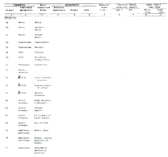
An explanation of the factors presented in columns 1 and 2:
Surface water: runoff, peaks and yields. Will/Does the project activity affect runoff. Will/Does it affect the peaks (flood discharges)? Will/Does it affect the amount of water flow?
Groundwater: its quality, recharge rates. Does/(Will)/Has the project alter(ed) its chemical composition?
Vegetation: Will/Has natural vegetation be/been reduced (bad) or increased (good)? How will/has natural regeneration be/been affected? Will/Has there be/been additional or fewer demands on trees, bushes, grasses, etc?
Soils: Will/Does the project increase or drain soil fertility? Where land surfaces will be/are affected by the project, does/has the best land use produce favorable or unfavorable results? Will/Has erosion be/been more or less likely?
Other: Basic questions dealing with favorable or unfavorable changes in wildlife, fisheries, natural features.
Food: Will/Do people have more food? Dry season foods? A more complete die
Disease: Will/Has the project create/created more standing water? Will/Has the project increase/increased fast flowing water?
Other: Basic questions dealing with toxic chemicals, exposure to animal borne diseases, etc.
Agriculture productivity: Will/Have per capita food production (staples or cash crops) yields be/been affected?
Volume of goods or services: Will/Has the project provide/provided more or fewer goods (food, firewood, water, etc.)?
Common resources: Water, pasture, trees, etc. Will/Has the project eliminate/eliminated community use of any of these resources? Will/Has it restrict/restricted access to these resources?
Project equity: How will/have benefits been distributed? Who will/has profited from these activities. How "fairly" will/have the benefits be/been shared?
3. Two separate operations are required: OBSERVATIONS (results from measurements or judgements 1-4); and CALCULATIONS (5-12)
4. Test the materials with a small group first so that the "bugs" (small problems) are worked out and facilitators become familiar with the tool.
5. Go through the exercise with community groups. Each group should produce a consensus statement stating which environmental factors should be most closely watched.
6. This tool can be used periodically throughout the project, to monitor changes in environmental factors.
The community should be heavily involved in the design of the tool (categories and questions). Avoid "fine-tuning" the tool and "applying" it to a community without their input.
This tool will not provide exact, mathematically precise measurements. However, it will provide systematic and consistent judgements which can be compared over time.
Leave room for new categories and questions that the group(s) may suggest during the exercise.
This is a somewhat complicated tool, so be sure it is well understood before using it.
This tool has recently been created, and has not yet been field tested. For further details see Weber in the Annotated Bibliography.
Survival surveys can be used to:
plan for nursery management;
measure the amount of community interest (protection, management, watering) in trees;
provide information about correct site/species selections;
increase the likelihood of overstock, based on mortality expectations;
determine reasons for mortality.
1. Serves as an "early warning indicator" for both technical and social problem areas.
2. The stocking rates can be adjusted to maintain optimal stocking targets.
3. Comparisons between communities can be made.
4. The quality of the nursery seedlings can be determined, (this will give information on seed sources, handling, planting, etc. but is more of a quality check than a survival survey, and is usually done soon after planting).
Time: some time may be needed to determine why and how farmers want to do a survival survey.
Expenses: depends on the methods, but minimal.
Training: some training on how to determine reasons for mortality and how to set sample size and choose methods for sampling.
There are at least two ways to do survival surveys. One is useful if a survival count is to be carried out on a macro-level on all the trees that have been planted. This is a useful tool if farmer/community records are not being kept. An appropriate and representative sample can give information on the extent to which trees have survived. It can sometimes also give some indication as to why some trees have not survived.
The other method, a micro-level count is useful if farmers or community members have kept their own seedling survival records. This type of survey uses a sample of their records to represent the community as a whole.
1. Determine (through discussions with beneficiaries) WHY a survival survey may be useful. HOW they may benefit from the information. WHICH information they need.
2. Design the survival survey. Consider the above information needs. There may be many different factors to consider: different configurations (woodlots, alleycropping, boundary planting, compound planting, random field planting, etc.), variation in species, possible reasons for mortality (weather, animal browse, etc.), different sites (dry/wet, fertile/infertile, etc.).
3. Decide how the survey will be administered. There are a number of options:
(a) when distributing seedlings, give each individual a card listing the number of each different type of seedling being taken. Ask that it be returned, with survival rates recorded, when receiving seedlings the following season;
(b) survival rates can be a part of the Farmer's Own Records (Tool 15). If this is the case, a representative sample of these records can be used;
(c) if micro-farm planning is done, a representative sample of the farms can be taken, and a survival survey can be done on a few farms;
(d) if no records of seedling distribution have been kept, an "as is" inventory can be made, and a survival survey can then be carried out in the future;
(e) for small communities, maps which record the households with seedlings, seedling species and seedling survival rates can be created and compared over time.
(f) demonstration plots (fenced areas with planted seedlings) can give "benchmarks" of seedling performance when seedlings are given optimum protection. These can be helpful if protection is a limiting factor.
4. A representative sampling methodology is probably a good idea. Stratify the sample by site conditions, agroforestry techniques, species, size, farm units, or programmes, etc.
Once you have stratified the sample, you must decide whether it makes sense to have a permanent (go back to the same trees every year) or a temporary sample (count only the trees planted in the last season).
NOTE: There has been a lot of difficulty with permanent samples because with many fast growing species it is very difficult to tell the age of a seedling. Tagged trees lose their tags. if permanent sampling is to be done, a map of the area that indicates each tree and it's planting date can help.
If sample accuracy is of concern, basic statistics may be required. Get help before beginning the survey if a high level of confidence in the data is required or/and if unsure about the process of statistical analysis.
5. It is important to decide WHEN to sample for survival. There are four discrete periods when trees should be checked. It is important to define the period in which the survival surveys are needed. Keep the period consistent over time.
(a) Initial Check: mainly to evaluate planting quality, handling practices.
(b) At end of limiting factor: drought, rain, pests, frost, etc. (this is usually what is meant by a survival count)
(c) At "free to grow" stage. This stage varies based on many different factors, such as height away from browse or height above competing vegetation.
(d) After spacing operations: when optimal stocking is assumed.
These sampling methods, when used, will give a "pretty good" estimate of survival, but may not be statistically valid. It is most important that the survey supply useful, and that fairly reliable information which is relayed to the beneficiaries.
Survival surveys are done once the LIMITING FACTOR has passed. This can be after the dry period, after herder's have passed through, after seasonal problems (wind and water) etc. A check on seedlings before this will not give reliable survival figures, although a check can be useful for determining restocking requirements.
Survival surveys are most useful as management tools, not as "success" indicators.
Be careful when identifying households where survival rates are low or management techniques may be poor. Public identification of planters with low survival rates can sometimes lead to divisiveness and decreased community cooperation.
Be consistent and systematic in conducting survival surveys as this will give useful information over time. Stick to the pre-selected sample and sampling methods so that bias is limited. Otherwise, results may not be reliable.
Community survival surveys were carried out in a forestry village project in India. Each community's "villager forester" had a map of the village and would put a coloured dot in the appropriate space for each different tree species planted in and around the village. If the tree died a circle was drawn around the dot. The "villager forester" reported "survival" to the project which did the analysis and presented the information to the village in simple chart form. In that way villagers could see survival by species and village. The maps, which were on display in the village, also gave a good indication of where trees did not survive ... which households did not protect or manage them well, and where poor site/species selection had been made.
MONITORING OF PARTICIPATORY FORESTRY ACTION RESEARCH
When participatory forestry action research is done in forestry related activities, the tools for monitoring (eg. yields, research plot records, soil traps) will help:
locally test new technologies (species, management practices, soil conservation measures, etc.);
determine the effectiveness of specific interventions when trees are planted to respond to a particular need;
support and strengthen indigenous research skills.
1. These tools identify research that is relevant to farmer's real needs.
2. These tools generate information that outside research agencies can use to identify their future research.
3. These tools give research high local visibility.
4. These tools show farmers the changes (positive or negative) brought about by interventions.
5. These tools lower the risks that could be associated with large scale promotion and adoption of a given approach.
6. These tools can hasten the adoption/rejection of new technologies.
7. These tools can strengthen participatory extension methods.
A number of tools are presented in this category, and each of them can be used to monitor specific aspects of participatory action research. Basic to all is a consistent, comparative and/or systematic measurement of some key indicators which will show the effects of the interventions.
Yields: farmers (communities) measure and record information. A separate booklet may be provided, or a section in the Farmers (Communities) Own Records (Tool 15).
Soil Traps: this is an example of a simple physical structure which is set up to monitor the effects of an intervention which may effect soil stability. Farmers (Communities) build and set up the soil traps, and measure and record the resulting information.
Research Plots: central-farmer initiated research plots. These plots are -established on communal or government land. They can be used to test interventions that could be risky to farmers. The inputs (measurements and records) should be provided by the project.
decentral-uses farmer initiated on-farm plots which farmers measure and record.
Time: varies based on the tool, but meetings and follow-up may take a great deal of time.
Expense: varies with the tool, but minimal.
Training: if the project staff has no experience in research design, help may be needed to design such things as research plots. However, with care, much of the actual research can be carried out by farmers.
1. Arrange a meeting of field staff and beneficiaries to discuss what interventions and management practices they wish to test, what methods they wish to employ (ie: whether it will be a test/control plot, or yields tests before and after treatments), the terms of measurement, and the method of measurement.
2. Field staff and key community members should then design the monitoring tool (this can be a separate booklet or an insert in Farmers'(Communities) Own Records (Tool 15).
3. Some monitoring methods:
Soil traps or sticks
-can be pits dug and shored up, or sticks with measurements carved or coloured on them. These can be used to study erosion control if soil runoff is monitored in areas with and without farmer interventions.
Research plots
-central (demonstration) plots are easier to manage and control. More "scientific" information can be collected. They may have higher community visibility. And records are centralized and shared with the community.
-decentralized (on-farm) research plots have value because they show variation in sites, they are more realistically managed in terms of labour inputs, and they may facilitate greater farmer-to-farmer interaction. Records are kept by each farmer and there can, therefore, be variation in results. Trends can, however be shown.
Yields
-to measure the effect of an intervention (alley cropping, windbreaks, boundary plantings, etc.) on crop yields, and the outputs from an intervention (poles, fodder, firewood, etc.). The units of measurements should be determined and recorded by the farmer.
Do not take land out of production for trials if farmers' yields, and therefore livelihood, is risked.
The increase in the attention being given to select farmers may lead them to feel that they need to apply more attention to the test plots (weeding, watering, etc.) than to the control plot. Results may in this way become inaccurate.
Other factors that could influence research results must be considered (ie: unusually heavy rains over one year might result in heavy erosion; use of improved crop seed could improve harvests; the number of years the land has been fallow could affect productivity, etc.).
Results over the long term will increase accuracy, and decisions should not be made on the basis of short-term results.
In a World Neighbor project in Mali, farmers identified their research needs; they were not satisfied with the quality of the new variety of short cycle millet that had been introduced. The field staff used dialogue to guide discussion. By evaluating different techniques, the farmers decided how to undertake trials. Ten individuals chose to undertake trials on small plots (10 steps by 10 steps) on their own land. Each trial plot represented the major variant conditions prevailing in the community (ie: fertile/poor soil; high/low land; early/late planting time, etc.) Farmer's grasped the utility of establishing control plots, and using the local variety of millet next to the trial plots.
After harvest, a community level evaluation was organized. Farmers reported their assessment of the results based on the criteria they had established: yield, flavor, drought and pest resistance, conservability and marketability. Disparities in the results were questioned, and ultimately the group decided to recommend that the new variety only be used under specific conditions.
The experience revealed "a remarkable ability among the farmers to test new technologies, analyse results, and formulate recommendations for use."
ILEIA (1988)
A small NGO in East Africa used informally trained community members as agroforestry extension workers for yearly evaluations of new agroforestry interventions in neighboring villages. Following these evaluation missions, villager/extension workers regularly came together to share their observations in an evaluation seminar. In one of these discussions the observed differences in coppicing a particular species were analysed. Further study was proposed and farmer designed and managed demonstration plot tests were planned. In this case, the approach permitted evaluation of different techniques without risk to farmers' trees.
