![]()
![]()
![]()
The survey area comprised the continental shelves and slope of Sierra Leone, Liberia, Côte d'Ivoire and Ghana, geographically situated between 9°10'N, 15°20'W and 6°8'N, 1°12'E ( Fig.1).
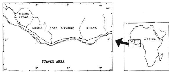
Fig.1. Location of the survey area
These four countries are located on the great bulge of West Africa, the northern boundary of the Gulf of Guinea. Their coastlines, extending for more than 2 000 km and composed of pre-cambrianic material, are bathed by the waters of the Eastern Central Atlantic.
SIERRA LEONE
In addition to the mainland proper, Sierra Leone also includes Banana, Turtle and Sherbro Islands, as well as other minor islets.
Its coastline stretches for 506 km and its total continental shelf area which descends to a depth of 200 m (at which point the slope cuts off) is about 27 500 km2 (Domain, 1979) (Map 5).
The western tip of Sherbro Island delimits two contrasting marine zones in terms of coastal morphology, topography and hydrography (Coutin and Payne, 1986). The southern shelf, from Sherbro to Liberia, is narrow, has limited fish resources (as will be seen below), and is influenced by the Equatorial Counter Current. Few rivers flow out along this coast.
The prograding northern coastline, from Sherbro to the border with Guinea, comprises extensive mangrove swamps and a number of estuaries and rivers that are navigable for short distances. A number of rocky outcroppings occur on the shoreward side of the shelf (as far as the 15–20 m isobaths) in the Saint Ann area in the Freetown region (Konate et al., 1989).
The shelf in northern Sierra Leone attains a width of 125 km and is a continuation of the vast Guinea Shelf. It represents more than 75% of the total shelf area, is Sierra Leone's productive zone (demersal, pelagic and shellfish resources are found there) and is influenced by the Canary Current. The major rivers (Scarcies, Sierra Leone and Sherbro) discharge large quantities of sediment along this coastline, the effects of which are felt both on the continental shelf and in the coastal region (Coutin and Payne, 1988).
The superficial sedimentary deposits on the northern shelf differ from those on the southern shelf (Williams, 1968). In the south, sediments consist of mud, sand and shells, while hard bottoms of gravel, shells and rock pre-dominate in the north. Softer, muddy sediments are nevertheless found near the coast and in the estuarine areas, and moving from the river mouths up to the rocky shelf edge, muddy, fluvial deposits begin to mix with marine sediments, sand and gravel.
The Saint Ann shelf also consists mainly of mud (Williams, 1963). These banks form a barrier roughly 30 km wide, 5–14 m deep, extending northeasterly from Sherbro island to the outer edge of the shelf in the extreme south.
There are no reef formations on these bottoms, although a number of consolidated structures have been detected at mid-shelf (between 20 and 60 m). These structures (crests and monticules) appear to be the remains of barriers and shelves belonging to former coastlines, which are now found mainly at 25 m depth (McMaster et al., 1970).
The most prominent geomorphological feature of the northern shelf is a number of submerged valleys (originally formed by rivers), following the same direction as the beds of present-day rivers (Sheridan et at., 1969). These former river beds are very deep, ending at the deep part of the shelf and slope in a system of very highly developed submarine canyons, through which sediment is transported to the ocean (Konate et al., 1989).
LIBERIA
The Liberian coast extends for 590 km and has a contintental shelf area of 18 400 km2. The present coastline is low and shows a number of depositional and erosional features, such as sandy beaches, lagoons, estuaries, mangroves, rocky bottoms (Ssentongo, 1987).
The continental shelf in the north between Monrovia and Cape Mount is narrower than in the south between Monrovia and the border with côte d'Ivoire, as indicated by the wider distance between isobaths. The slope breaks at about 200 m (Map 6).
The Bay of Monrovia is the only sedimentation basin in the area and is covered with thick layers of mud, carried by the Saint Paul river.
A coastal strip consisting of isolated, sharp rocks projecting from soft bottoms extends from the capital in a southeasterly direction. This rocky strip gradually widens to cover the sea floor to depths of up to 80 m off Cape Palmas. The remainder of the continental shelf, made up of soft sediment, mud and sand in differing proportions, extends in parallel strips all along the coast. Also parallel to the coast, between 80 and 200 m, are fossil coral banks dating from the Holocene period.
CÔTE D'IVOIRE
The Côte d'Ivoire coastline displays two different typologies. From Cape Palmas to Fresco the coastal fringe is rocky, while from Fresco to the border with Ghana, the coast, associated with an area of subsidence, is low, sandy and bordered with lagoons.
The sedimentology and morphology of the continental shelf is well-known (Martin, 1971, 1973). The shelf is narrow, covering some 10 200 km2, with the slope starting at about 125 m. Its width varies from 10 miles in the narrow area off Abidjan, to 19 miles east of Sassandra (Map 7).
Its topography down to 2 000 m depth in the area between Sassandra and Grand Bassam has been studied in detail (Martin, 1973). The sea beds are on the whole fairly flat, with few irregularities except for a marine canyon, known as “le Trou sans fond” (the bottomless hole), which cuts through the shelf off Abidjan (Martin, 1970). Nearby, a series of submarine canyons cut through the outer edge of the shelf and slope and continue below 2 000 m. In the remainder of the area studied, the slope is very irregular and cut by many smaller canyons.
Attention is drawn to the presence of rocky banks or reefs running for long distances parallel to the coast between the 55 and 100 m isobaths. These coral-type formations up to 5–6 m in height are the remains of former coastlines (“beach rocks”) which originated during past regressions when the sea level was 70–90 m lower than now. In addition to these hard bottoms, isolated rocky outbreaks are found between 0 and 50 m depth on the country's western coast.
As regards sedimentary deposits, the continental shelf is characterized by a covering of mud around the river mouths. One muddy zone, formed by discharge from the Cavally, San Pedro and Sassandra rivers, is found at depths of 30–70 m from Cape Palmas to Sassandra, and another in the vicinity of the Bandana river stretches to the shelf edge. The small muddy area located off Grand Lahou bears no relationship with the emptying of any of the present rivers. The last major muddy zone lies between Grand Bassam and “le Trou sans fond” and is associated with deposits from the Komoe river.
The remainder of the continental shelf is covered with sand (of grain size varying from very fine to coarse), mixed with mud in varying proportions. These sediments, from 70 m depth to the slope, are organogenic, consisting of more than 70% calcium carbonate and associated with the isolated rocky outbreaks and reefs.
GHANA
The Ghanaian coast extends for 536 km. The continental shelf area up to 200 m is 23 700 km2.
The coastal area consists of several different morphological types: the coast between Axim and Cape Three Points is low and marked by a wide, flat beach and a coastal lagoon on the inshore side. Between Cape Three Points and Tema, the coast consists of rocky promontories and sandbanks encircling lagoons (Ly, 1980). To the east of Tema, the coast is low and sandy once again, forming part of the western side of the Nigerian sedimentary basin (martin, 1971). The mouth of the Volta, one of the largest West African rivers, is located in this last stretch. Recession of the coastline here increased from 4 m/year to 8–10 m/year following the construction of the Akosombo dam across the Akosombo river, which prevents 99.5% of the river's sediment from reaching the sea (Ly, 1980).
The general configuration of the Ghanaian continental shelf is controlled by various break systems which appear to extend to the edge of the slope (Cudjoe and Khan, 1972). The shelf attains its maximum width of 100 km between Takoradi and Cape Coast, narrowing eastwards to Cape Saint Paul, where it reaches its minimum width and slopes sharply (Map 8).
The sea floor off the mouth of the Volta, where the 20 m isobath reaches the edge of the continental shelf, consists of a large submarine delta formed by river deposits.
Apart from this physiographical feature, the Ghanaian continental shelf presents no other irregularities of note, except for a belt of dead madreporaria coral at 75 m depth, which seems to mark the start of the slope.
Soft sediment (mud and sandy mud) predominates along the coast and below the coral belt. The central part of the continental shelf has hard bottoms, which are widest off Takoradi, and extend eastward. They consist of flat rocks and shoal and are are covered by large gorgons, branched corals and briozoons (Rijavec, 1980). Mixed gravel and pebble bottoms, on the other hand, are usually covered with corallinaceous algae.
The climatology of the area, characterized by high temperatures, high humidity and heavy rainfall, and two alternating seasons (the dry season from November to April and the wet season from May to October) greatly influences oceanographic conditions, affecting marine resource distribution and fisheries.
The surface waters of the Gulf of guinea are basically warm (temperatures above 24°C) and of low salinity (below 35°00), the result of heavy rainfall and high river discharge during the wet season.
These surface waters circulate in an easterly direction along the West African coasts from Senegal to Nigeria. Two currents bring their waters to the Guinea Current (GC): the Equatorial Counter Current (ECC) moving eastward, and the Canary Current (CC) (Fig. 2).
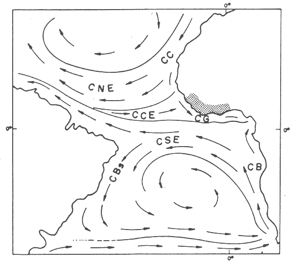
Fig. 2. System of surface currents in the Central Atlantic
The cold, high salinity waters of the Southern Central Atlantic region lie below these 30–40 m of tropical waters. The water separating these two types of water is a transition layer, termed the thermocline or halocline.
The hydrographic regime in Gulf of Guinea waters is affected by a relatively stable, shallow thermocline, which extends along most of the West African coast between 20 and 35 m depth. Usually lying at mid-shelf and oscillating vertically on a seasonal basis, according to the fluctuations of the equatorial current system, the thermocline has a significant effect on fish distribution.
Taking the Gulf of Guinea as a whole, the thermocline rises to the surface at the northern and southern extremities of the surface layer, forming two fronts, and the surface isotherms narrow where these fronts occur (23–27°C).
These fronts are not fixed; they move, depending on the season of the year (affected, at least indirectly, by the movements of the intertropical front and the intensification of the trade winds). During the northern winter, the northern front lies in the region of Cape Verga and the southern front near Cape Frío. Six months later, during summer, the fronts will have moved northwards and southwards respectively, to Cape Blanc and Cape Lopez (Fig. 3).
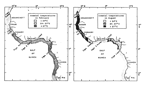
Fig.3. Position of the warm upper layer and upwelling areas during northern winter and summer
In the central part of the Gulf of Guinea, off Côte d'Ivoire and Ghana, the warm surface layer disappears during the cold season (third quarter), causing an upwelling of colder, more saline deep water, which fertilizes the upper layers as it rises. Although a possible correlation between upwelling and the existence of winds blowing parallel to the coast has been suggested (Longhurst, 1962), more recent studies would appear to confirm that the local effect of the wind would not suffice to cause these upwellings, and that long waves and currents play an important role (Picaut, 1983; Bussalachi and Picaut, 1983; Houghton, 1983).
The Gulf of Guinea is therefore flanked by two high-productivity areas, situated north of Cape Verga and south of Cape López, its own waters being evidently very poor, except for Côte d'Ivoire and Ghana which are seasonally enriched by local upwellings.
From the viewpoint of oceanography and productivity, the survey area comprises a number of very different sectors.
SIERRA LEONE
The hydrographic situation of the Sierra Leone continental shelf is complex due to the fact that this is the area of convergence of the three major seasonally fluctuating ocean currents, the Canary Current, the Equatorial Counter Current and the Benguela Current.
As already stated, the characteristics of the water masses in northern Sierra Leone differ greatly from those in the south (there is apparently an ecological barrier between them) and as a result, they are usually treated as separate units (Coutin and Payne, 1986).
The northern part of the Sierra Leone continental shelf is particularly isolated from the northern and southern upwelling areas by the physical barriers formed by the Bissagos archipelago and the Saint Ann banks. It is nonetheless the most productive part of the coast, probably due to the strong influence of effluents from the many rivers emptying into the sea in this area.
River discharge also affects salinity. It is known that at the end of the wet season (October), the 33 o/oo salinity isoline coincides with the 30 m isobath in the north and the 200 m isobath in the south.
LIBERIA
Liberia, situated in the area of permanance of the “Guinean waters”, is biologically very poor. The thermocline in the Liberian shelf can be as shallow as 12–14 m, which means that there is no renewal of water, very low productivity and that fertilization is by river effluents rather than by seasonal upwellings.
CÔTE D'IVOIRE AND GHANA
The Côte d'Ivoire and Ghana shelves are affected by the seasonal upwellings which take place in the Gulf of Guinea central upwelling area, stretching from Cape Palmas in Côte d'Ivoire to Cotonou in Benin (Williams, 1969). Most of these upwellings occur from July to September between western Côte d'Ivoire and Cape Three Points in Ghana, but other less intense ones occur between December and January. In both cases, they appear to move from east to west and to be stronger along the Ghanaian coasts, in the vicinity of Takoradi, to the east of Cape Three Points.
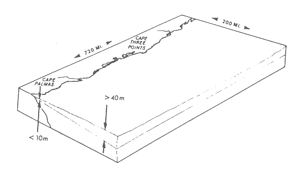
Fig. 4. Diagram showing the position of the thermocline on the Côte d'Ivoire and Ghana continental shelf (based on Ingham, 1970)
The Eastern tropical Atlantic is poorer than other tropical regions as regards marine species. Its waters contain an insignificant number of endemic genera and very few demersal species (Longhurst, 1983). There are various reasons for this, some of which have already been discussed. Apart from the very shallow surface layer, the major climatic regressions which occurred in the eastern basin of the tropical Atlantic during the Quaternary, made it impossible to preserve the fauna from the Tertiary to the present time (Ekman, 1953).
The faunal homogeneity of all the Gulf of Guinea demersal species has been stressed by several authors, on the basis of data obtained through demersal trawling surveys conducted in the area. The demersal species of the Western tropical Atlantic have been classified into different communities according to their ecological characteristics. Available data show that the factors determining the distribution of these species on the continental shelf are depth, substrate type (rock, mud, sand) and hydrological conditions (Villegas and García, 1983).
Fager and Longhurst (1963) and Longhurst (1969) provided a detailed and objective description of tropical demersal fish assemblages and their affinities showing how they coincided with previous, more subjective classifications.
These tropical communities occupy the entire Gulf of Guinea, as far as the latitude of Cape Blanc (Mauritania) to the north (at which point the Guinean fauna gives way to a fauna with Saharian and warm temperate affinities), and Cape Frío (Angola) to the south.
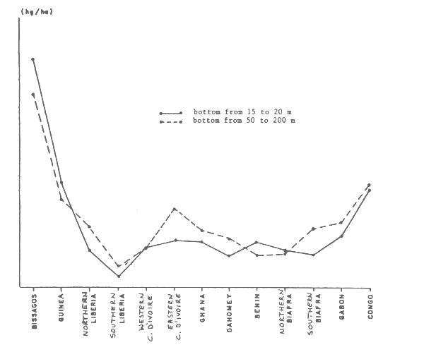
Fig. 5. Relative density of demersal species along the continental shelf between Senegal and Angola (based on Williams, 1968)
Despite this high degree of homogeneity, demersal biomass distribution varies considerably along the coasts due to variations in oceanic productivity (Fig. 5) and, to a greater or lesser extent, to the migratory habits of some species (travelling from the coast to the open sea or vice versa at given times of the year).
Seven different communities may be distinguished on the Gulf of Guinea continental shelf (Longhurst, 1969). Their species composition is given in Table 1.
1. Sciaenid Community
This community is represented by species of the Sciaenidae, Polynemidae, Pomadasyidae, Ariidae, Drepanidae and Clupeidae families. Croakers (Pseudotolithus) are the dominant species (both ecologically and commercially).
This community inhabits the soft, sandy and muddy bottoms at depths of between 15 and 50 m up to the base of the thermocline.
A variant of the same community occupies low salinity waters in estuarine areas.
2. Lutjanid Community
This community consists of a number of species of the Lutjanidae, Acanthuridae and Chaetodontidae families, which inhabit rocky and fossil dune bottoms at depths of between 15 and 40 m.
The lutjanids are the most commercially valuable species.
3. Coastal Sparid Community
This community, comprising mainly Pagellus bellottii, Pagrus caeruloestictus and Dactylopterus volitans, among others, lives above the thermocline on hard or sandy substrates between 15 and 70 m depth.
4. Deepwater Sparid Community
This is the dominant community below the thermocline on soft bottoms between 40 and 200 m depth. It includes Sparidae (Dentex angolensis and Dentex congoensis), Triglidae, Uranoscopidae, the brotulid, Brotula barbata, and the deepwater sciaenid, Pentheroscion mbizi. It also comprises other species such as Pagellus bellottii, Epinephelus aeneus, Raja miraletus and Pseudupeneus prayensis, although these are not found in such depths as the former.
5. Deep Shelf Community
6. Continental Slope Community
Although a number of species of these two communities have been defined ecologically (see Table 1), they are not exploited commercially by any type of fishing fleet.
7. Eurybathic or Thermoclinal Species
Among these species, which have not been assigned to any group, are some typical eurybathics such as Trichiurus lepturus and Cynoglossus canariensis, as well as other coastal species like Penaeus duorarum. Environmental, temperature and salinity conditions in this zone differ widely at any given time (Caverivière, 1983).
| Sciaenid Community | Sparid Community (coastal) | Deep Shelf Community |
|---|---|---|
| Brachydeuterus auritus | Chilomycterus antennatus | Peristedion cataphractum |
| Galeoides decadactylus | Pagrus ehrenbergi | Antigonia capros |
| Vomer setapinnis | Dentex canariensis | Zenopsis sp. |
| Pseudotolithus senegalensis | Balistes capriscus | Synagrops microlepis |
| Pseudotolithus typus | Dactylopterus volitans | Bembrops heterurus |
| Arius spp. | Pterothrissus belloci | |
| Ilishi africana | Sparid Community | Monolene microstoma |
| Pteroscion peli | (deep-water) | Chlorophthalmus sp. |
| Drepane africana | ||
| Pomadasys margarita | Priacanthus arenatus | Continental Slope |
| Cynoglossus browni | Fistularia villosa | Community |
| Pentanemus quinquarius | Pseudupeneus prayensis | |
| Sphyraena spp. | Epinephelus aeneus | Chaunax pictus |
| Ephippion guttifer | Pagellus coupei | Benthodesmus tenuis |
| Chloroscombrus chrysurus | Raja miraletus | Setarches guentheri |
| Lagocephalus Laevigatus | Dactylopterus volitans | Epigonus telescopus |
| Gerres melanopterus | Sardinella aurita | Galeus polli |
| Torpedo torpedo | Moridae | |
| Eurybathic or | Mustelus mustelus | macrouridae |
| Thermoclinal Species | Boops boops | Etmopterus pusilus |
| Scomber japonicus | Halosaurus oweni | |
| Trichurus Lepturus | Trachurus spp. | Cyttus roseus |
| Cynoglossus canariensis | Pentheroscion mbizi | merluccius spp. |
| Parageleus gruveli | Brotula barbata | Trigla Lyra |
| Scoliodon terranovae | Uranoscopus albesca | Dibranchus atlanticus |
| Platycephalus gruveli | Lepidotriglia cadmani | Gonostomatidae |
| Torpedo torpedo | Lepidotriglia Laevispinis | Hypoclidonia bella |
| Dentex angolensis | Chascanopsetta sp. | |
| Lutjanid Community | Dentex congoensis | |
| Squatina aculeata | ||
| Lethrinus aclanticus | Paracubiceps Ledanoist | |
| Lutjanus goreensis | Smaris macrophthalmus | |
| Lutjanus agennes | Saurida parri | |
| Balistes forcipatus | Eucitharus Linguatula | |
| Chaetodon hoefleri | Sphyraena spp. | |
| Acanthurus monroviae | Lagocephalus Laevigatus | |
| Ostracion tricornis | Scyacium micrurum | |
| Neanthias accraensis |
The artisanal and industrial fisheries operating in Gulf of Guinea waters direct their fishing efforts to many of the demersal species mentioned above. The sciaenid, lutjanid and sparid communities include species of high commercial value, such as croakers (Pseudotolithus), Lutjanus, soles (Cynoglossus), groupers (Epinephelus) and a number os sparids, including dorados and snappers (Dentex). Other species worthy of mention are the coastal penaeids (Penaeus and Parapeneopsis atlantica), as well as skate and shark species.
The first signs of overexploitation of coastal demersal stocks were localized within restricted areas. Deepwater demersal stocks, on the other hand, are underexploited (Poinsard and García, 1984). Furthermore, very little is known about the general state of demersal resources since resource assessment surveys over the past ten years have been very few.
In this section, each country's resource potential, fisheries and the species fished are reviewed, as well as the major demersal resource surveys conducted along their respective coasts. A summary is provided by van der Knaap (1985).
SIERRA LEONE
There are no reliable data on Sierra Leone's resource potential, pelagic or demersal, but the pelagic fish potential is probably less than 100 000 t, while that of demersal fish is estimated at some 30 000 t (Ssentongo and Ansa-Emmim, 1986).
Sierra Leone's resources are exploited by both artisanal and industrial fisheries. The catches of the artisanal sector, using handlines, gillnets, driftnets, encircling nets, etc., represent about 90% of national fish landings, 70% of which comprises small pelagics (Sardinella, Ethmalosa and Ilisha africana). The fishing grounds are located around the estuaries north of Sherbro and in the coastal areas, between 20 and 40 m depth.
Industrial fishing has traditionally been done by a number of foreign trawlers and purse-seiners, although efforts have been made in the last ten years to boost the capacity of the national industrial fleet, which focuses its efforts on several demersal species, including croakers (Pseudotolithus), soles (Cynoglossus), grunters (Pomadasys), threadfins (Polynemidae) and various sparids. Crustacean fishery efforts focus on three penaeid species. Penaeus notialis is the most abundant, and is fished with P. kerathurus in the northern zone below 100 m. The best fishing grounds for these species are around the Freetown Peninsula, Banana Island and Turners Peninsula and the best fishing season is from April to September. The third species, Parapenaeopsis atlantica is fished mainly in southern Sierra Leone. Parapenaeus longirostris is not as abundant and the fishery has not yet been developed.
Biomass estimates have been based on the findings of various resource assessment surveys, including the Guinean Trawling Survey (1963–1964), the joint USSR/Sierra Leone surveys (AtlantNIRO, 1983) conducted between 1976 and 1982, and the R/V DR. FRIDTJOF NANSEN 1981–82 surveys (Stromme, 1983; CEFAF, 1984). Williams' biomass estimates (1968) based on GTS data for all fish, obtained by the swept area method, were as follows:
| Continental shelf | 15–50 m | 50–200 m |
|---|---|---|
| Guinea/Sierra Leone | 188 000 t | 40 000 t |
| Sierra Leone/Liberia | 18 000 t | 27 000 t |
Total fish biomass (excluding Balistes), estimated on the basis of data gathered by the USSR surveys, was 547 000 t, while the FAO estimate from data collected by the R/V DR. FRIDTJOF NANSEN (still excluding Balistes), was 317 000 t.
Biomass estimates for demersal stocks, obtained by Longhurst (1983) from an analysis of their carbon content, were much lower:
| gC/m2 | t/km2 | |
|---|---|---|
| Sciaenid community | 0.25 | 1.88 |
| Sparid community | 0.10 | 0.75 |
LIBERIA
The findings of a number of trawling surveys point to the scarcity of demersal species in Liberian waters. Their potential biomass has been estimated at 9 000–15 000 t, while the potential of coastal pelagic species is reported to vary between 19 400 and 41 400 t.
Liberia's artisanal fisheries are not as developed as the industrial fisheries, whose annual catches are estimated at around 12 000 t (FAO, 1986). Artisanal fisheries, centred mainly in the Montserrado and Grand Bassa regions, catch between 1 000 and 2 000 t. Sixty percent of this catch consists of coastal pelagic species (50% Sardinella), but tuna (10%) and other species such as barracudas, sole, croakers, shark and skates are also caught.
The industrial fleet exploits mainly demersal species (croakers, threadfins and sparids) and coastal penaeids. The catch composition indicates that the coastal sciaenid community is now the most exploited (until the early seventies, this record was held by the crustaceans). Crustacean fisheries target P. notialis, intensively fished in the northern area, and P. atlantica.
Deepwater sparid and crustacean industrial fisheries have not yet been developed and although no biomass estimate of the stocks on the slope has yet been made, data obtained in adjacent waters suggest that they are neither very abundant nor very profitable (Ssentongo, 1987).
The following trawling surveys have been conducted in the area: the Guinean Trawling Survey (1963–64), the surveys of the Centre de Recherches Océanographiques (1964–65), the Freetown Fisheries Research Institute survey in the north (1952–57), the BIRKUT (1961) and BELOGORSK (1981) surveys. Their findings all indicate a scarcity of demersals in Liberian waters. Biomass estimates have put maximum production potential (excluding Brachydeuterus) at 9 000 t.
According to GTS findings, maximum catches of commercial species occur between 30 and 40 m (the depths at which most crustaceans are caught). At greater depths, the most-harvested species was B. auritus, less valuable commercially. Catch rates both in coastal waters and off-shore are higher in the north than in the south (Williams, 1968).
Catch rates were extremely variable during the BELOGORSK survey (which covered bottoms up to 900 m), but the largest were obtained on the shelf edge (200 m). As regards demersal species, biomass estimates were highest for Dentex angolensis and D. congoensis (3 500 and 3 100 t respectively), followed by E. aeneus (2 010 t).
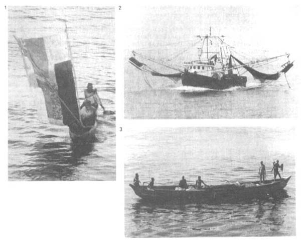
Local fisheries
Dugout canoe (fitted with a sail) off King Wills (Liberia)
Outrigger trawler in Monrovia Bay
Dugout canoe in the Tema area (Ghana)
CÔTE D'IVOIRE
Many demersal trawling surveys have been conducted in Côte d'Ivoire. In addition to the 1981 DR. FRIDTJOF NANSEN and the 1963–64 Guinean Trawling Surveys, others were carried out periodically between 1979–80 and 1983–84 for the purpose of biomass estimation. Three of them focused on deepwater crustaceans, but these data are unavailable.
Fishing potential for the whole of the Ivorian shelf would appear to be between 13 000 and 15 000 t (balistes excluded). Global models (again for the whole of the shelf) based on commercial catch data put the demersal stock potential in Côte d'Ivoire at 9 000–10 000 t during the period prior to the appearance of dense concentrations of Balistes (1959–70) and at some 6 000 t in the period 1971–85 (Bard et al., 1988). the abundance of this species appears to have decreased, especially since 1986, probably due to the return of a more normal rainfall pattern in the region.
Artisanal fisheries are exploited mainly by fleets from Ghana, Liberia, Senegal and Togo, since the Ivorians are not professional fishermen and only practise fishing as a subsistence activity. Groupers, lutjanids, Lethrinus, “sea breams”, “red porgies” and some sciaenids, as well as skate and shark, are fished with handlines and longlines.
Industrial fishing is done by trawlers of varying capacity (from 300 to more than 600 CV), operating from Ghana and Mauritania. Their numbers had been on the decline until 1980. Landings over the past ten years have fluctuated between 5 000 and 6 000 t, with the most abundant species being croakers (1 300 t/year on average), sparids, such as Dentex, Pagellus and Pagrus (1 200 t) and big-eye grunters (B. auritus) (1 000 t/year).
GHANA
Ghanaian fisheries (both artisanal and industrial) have a long history, with first attempts at mechanization dating back to 1946 (Bernacsek, 1986).
Of the four sectors under which the country's fishing activities may be classified (artisanal, coastal semi-industrial, off-shore industrial and tuna fisheries), the artisanal fishery is the most important.
The main gear used in artisanal fishing are encircling nets, with which anchovy and sardine, Sardinella aurita, are caught, especially during and after the upwelling season.
The semi-industrial coastal fleet also catches Sardinella (with encircling nets) and Balistes capriscus (with trawling gear), while catches of sparids, Sardinella aurita and two species of carangids, Decapterus punctatus and Trachurus trachurus dominate deeper water fisheries.
A number of demersal fishery surveys have been conducted in Ghanaian waters, including the Cape St. Mary bottom trawling surveys (1956), which covered depths up to 360 m, the Guinean Trawling Survey (1963–64), the Research Survey (1969–1970), the KAKADIAMAA surveys (1979–80; 1981–82), the DR. FRIDTJOF NANSEN survey (1981) and the SAGONAA survey (where bottom gillnets were used).
Demersal fish resources have been estimated at 328 000 t, with Balistes accounting for 95% (Stromme, 1984). Among the other species, the sparid biomass (S. caeruloestictus, D. congoensis and P. bellottii) has been estimated at 30 900 t (Koranteng, 1984).
![]()
![]()
![]()