Conjunctive use of surface and groundwater
SURFACE WATER OR GROUNDWATER?
Disadvantages of surface water development compared to groundwater
In most climates of the world, precipitation, either rain or snow, and consequently peak runoff corresponding to a significant part of the total discharge of the rivers, occur during a particular season of the year which usually coincides with the smallest water demand. The water development problem therefore consists of transferring water from the high supply season to the high demand season. The most obvious and the most common solution to that problem consists of storing surface water behind dams, but storage of water in the ground may be a valuable alternative to surface storage systems, although not always systematically considered when planning water development. Yet surface reservoirs have many drawbacks, especially:
• evaporation: large open water areas are exposed, during several months and even years, to high evaporation rates leading to water losses sometimes exceeding 20 percent of the average annual runoff. Losses may be even higher when the width of the impounded valley is considerable, and induces a larger open water area.
• sedimentation: soil erosion in the catchment results in siltation in the surface reservoirs and in the equivalent reduction of the storage capacity. The soil vulnerability to erosion, and therefore the importance of the siltation problems in surface reservoirs, grows as the vegetation cover shrinks, so the more arid the climate, the less the vegetation cover, the higher the probability of sediment accumulation in the surface reservoirs. Draining part of the mud from the reservoirs is occasionally possible through specially designed pipes placed at the bottom of the dam, but each operation is water consuming (to flush the mud) and may be detrimental to downstream environment.
• environmental impact of surface reservoirs may often be highly undesirable for human health, flooding of inhabited, or good agricultural land,
• distribution of water from the reservoir may be expensive and requires the construction of costly canals because of the distance between dam and utilization areas.
P. Pallas, Water Resources
Development and Management service, FAO, Rome |
Evaporation in Lake Nasser Since
the beginning of impoundment of the High Asswan Dam in
1964, the lake has progressively increased to a total
surface area of 6000 km2, with an average
width of 12 km and a length of 500 km. Total average
annual losses had been estimated at 9 km3 for
evaporation and 1 km3 for seepage and
absorption. Considering that Egypt Nile water allocation
corresponds to 55.5 km3, hence losses by
evaporation would represent 16 % of the present water
allocation of Egypt, enough to meet the requirement of
perhaps 500 000 ha under irrigation. |
Morocco: Loss of storage capacity of surface reservoirs due to sedimentation Sediment accumulation in surface reservoirs, now amounts to 50 million m³/year and is expected to increase to 100 million m³/year when the remaining large dams construction programme will be achieved. The present annual loss of storage capacity of surface reservoirs in Morocco is equivalent to the annual volume required to irrigate 6 000 ha. Source
: Aménagement des bassins versants et protection des
barrages contre l'envasement Conseil supérieur de l'eau
- 5ème session. |
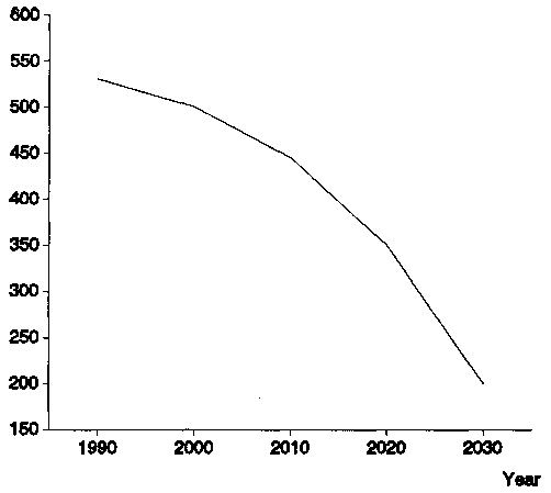
MOROCCO - MOHAMED V RESERVOIR: Reduction of storage capacity
In contrast, groundwater is not exposed to evaporation; does not suffer from reduction of storage capacity because of siltation; is seldom harmful to environment and offers a natural water distribution up to the users.
Why is surface water storage always preferred to groundwater development?
When looking at these advantages and disadvantages, groundwater seems to be a better alternative that should be preferred, but this not the case; large and concentrated water demand such as that from large irrigation schemes is usually supplied from surface water storage, and there are various reasons for that choice:
• groundwater aquifers seldom offer large storage capacity able to absorb large volumes of flood in a short period of time, and are unable to return them as significant discharge per unit production system of well or borehole,
• surface water storage, because of the large investments involved, is often preferred because it offers a much higher political visibility and because high construction costs give an opportunity for private profit and corruption, opening the way for improper influence on decision making.
A reasonable solution
Conjunctive use of surface and groundwater consists of harmoniously combining the use of both sources of water in order to minimize the undesirable physical, environmental and economical effects of each solution and to optimize the water demand/supply balance. Usually conjunctive use of surface and groundwater is considered within a river basin management programme - i.e. both the river and the aquifer belong to the same basin.
Assuming that the mixed solution is part of the national policy, several problems need to be carefully studied before selecting the different options and elaborating a programme of conjunctive use of surface and groundwater:
• underground storage availability to be determined,
• production capacity of the aquifer(s) in term of potential discharge,
• natural recharge of the aquifer(s)
• induced natural recharge of the aquifer(s)
• potential for artificial recharge of the aquifer(s)
• comparative economic and environmental benefits derived from the various possible options.
UNDERGROUND STORAGE AVAILABILITY AND PRODUCTION CAPACITY OF THE AQUIFER
In order to use the underground reservoir to store a significant volume of water - possibly of the same order of magnitude as the annual runoff - with the intent to use it at a later stage, it is necessary to ascertain the potential storage capacity of the groundwater reservoir as well as its suitability for being recharged by the surface water and for easily returning the stored water when needed. The groundwater reservoir should present sufficient free space between the ground surface and the water table to accommodate and retain the water to be recharged, for the period during which water is not needed. This condition requires accurate hydrogeological investigations including geological mapping, geophysics and reconnaissance drilling, in order to determine the configuration and the storage capacity of the underground reservoir.
The suitability of an aquifer for recharging may be estimated from the following parameters:
• surface material has to be highly permeable so as to allow water to percolate easily;
• the unsaturated zone should present a high vertical permeability, and vertical flow of water should not be restrained by less permeable clayey layers;
• depth to water level should not be less than 5 to 10 m;
• aquifer transmissivity should be high enough to allow water to move rapidly from the mound created under the recharge basin but should not be too high (as in karstic channels) so that water cannot be recovered.
An adequate transmissivity for recharge is also a good indicator of the aquifer capacity to produce high well discharge and therefore easily to return the water stored.
NATURAL AND INDUCED RECHARGE OF THE AQUIFER
Should a significant natural recharge of the aquifer occur from the surface runoff and the deep percolation of rainfall, and should the average annual amount of recharge be of the same order of magnitude as the water demand, there would not be the need for any additional human intervention. On the contrary, any tentative modification of the natural course of surface water may significantly alter the groundwater renewable resources. There are many examples of double counting of water resources as if surface and groundwater were independent. Because of this wrong approach, dams have been built with the intent to store the surface water and to create an additional resource. The resulting situation has often been catastrophic with rapid depletion of the aquifer not recharged any more, destruction of the ecosystem based on the groundwater and extreme difficulty to go back to initial conditions.
Induced natural recharge occurs when intensive exploitation of groundwater close to a river results in an important depression of the groundwater level and in a water inflow from the river. This phenomenon is well known in temperate climate where rivers flow all year long; but it may also occur in semi-arid climates where a depression of the piezometric level of an aquifer underlying a temporary river creates the empty space in the aquifer which facilitates its recharge during floods.
ARTIFICIAL RECHARGE
Artificial recharge of aquifers can be achieved using three different methods, namely surface spreading, watershed management (water harvesting) and recharge wells.
Surface spreading
Artificial recharge by the spreading method consists of increasing the surface area of infiltration by releasing water from the source to the surface of a basin, pond, pit or channel. This is certainly the most efficient and most cost-effective method for aquifer recharge. However, only phreatic (unconfined) aquifers can be recharged by the spreading method, which also requires large surface areas to accommodate the recharge scheme, allowing water to evaporate if percolation in the ground is slow.
Surface spreading usually needs two structures: the diversion structure and the infiltration scheme.
Diversion structures are the same as those used for spate irrigation. The traditional methods, based on centuries of experience, are well adapted to the conditions of arid land wadis. They consist of the construction of earthen bunds (ogmas) and deflectors across the wadi to divert the flow into the fields. But large spates usually destroy the ogmas and reduce irrigation of the fields. Furthermore, the very high sediment content of spate water tends to fill the diversion canals, which have to be cleaned regularly. So, although the ogmas are relatively inexpensive to rebuild, the overall cost of seasonal maintenance and repair of the scheme is high.
Performance of infiltration basins Permeable
soils and particularly coarse alluvial deposits have
vertical hydraulic conductivity ranging from 1 m/day
(fine loamy sands) to 10 m/d (sand and gravel mixes).
However, because of clogging, the actual infiltration
rate of recharge basins generally varies from 0.3 to 3
m/d. The quantity of water infiltrated obviously varies
with the duration of the source of water which may be
limited to a few days per year if no surface water
storage facility exists. In any case, the total duration
of the infiltration process will seldom exceed 100 days
per year since, if a surface reservoir controls the
floods, infiltrating water in the ground would be
competitive only if it can be achieved in less than 100
to 150 days. The volume that one can reasonably expect to
be infiltrated in basins will therefore range
approximately from 100 000 to 3 000 000 m3/year/hectare |
Several techniques have been tested with the objective of achieving a better control and regulation of spate and reducing sediment transport in the canals. Due to the hydrological characteristics of wadis, it soon became evident that it is not economic to provide diversion weirs which will control the probable maximum flood. Thus, the tendency nowadays is to build diversion structures with a canal head regulator, sediment excluder and a spillway on one flank and a fusible dyke across the wadi. Unfortunately, present design and feasibility studies are often hampered by lack of adequate data on spate runoff. These techniques were developed with the intention of improving the spate irrigation systems, but the results can apply to the diversion structures (diversion weirs) needed for artificial recharge by surface spreading.
The infiltration scheme may consist of basins, channels or pits depending on the local topography and on land use. The most common system consists of a number of basins each one having an area ranging from 0.1 to 10 ha according to space availability. Each basin must have its own water supply and drainage so that each basin can be flooded, dried and cleaned according to its best schedule. Basins should never be in series, because in such a system, they cannot be dried and cleaned individually. Often the first basins are used as pre-sedimentation facilities.
In the vicinity of urban agglomerations, pits may have been dug in ancient paths of wadis in order to extract construction material (gravel, sand). The depth of these pits may range from 2 to 3 m up to 30 to 40 m. Pits may also be excavated for the specific purpose of artificial recharge. Aquifer recharge simply consists of diverting water from the main channel to the pit. Even with a deep pit, it may be advisable to have a smaller settling pit between the main channel and the larger recharge pit. Both recharge and settling pits should be fenced and have a suitable inlet so that the inflowing water does not erode the walls of the pits.
Other techniques may also be identified with the surface spreading method: spate irrigation, check dams, underground dams and sand dams.
Spate irrigation is a well known traditional technique in the Near East consisting of watering terraced fields which flank the wadi, by diverting flood flows into them. Although the primary objective of spate irrigation is not aquifer recharge, this technique usually contributes significantly to increasing the infiltration of water into the underlying groundwater reservoirs. The storage of excess water into the aquifer and its subsequent retrieval alleviates some of the risks inherent to runoff based irrigation in arid zones.
Check dams are small structures built across wadis with a view to slowing down the velocity of water, allowing it to percolate into the alluvial aquifer. When the wadi usually flows into a narrow channel surrounded by plains located a few metres above the bottom of the channel, check dams may be built in the channel, raised 1 to 2 metres above the ground level of the plain and extended laterally by two wings crossing most of the valley. The flood is then forced to expand over a large area, thus facilitating the infiltration of water.
Underground dams apply in shallow depth alluvial deposits to prevent groundwater (underflow of the wadi) from flowing away immediately after it is stored in the aquifer. They consist of digging a 1 to 1.5 m wide trench across the valley, down to the bedrock (which should be impervious) and then filling the trench either with loose impervious material (clay) or by building a wall made of local bricks. Underground dams may be complemented by sand dams consisting of raising the dam above ground by 1 or 2 metres so that the solid transport (usually sand and gravel) of the floods can accumulate behind the surface dam and thus increase the storage capacity of the alluvium.
Watershed management and water harvesting
Watershed management offers an effective method to intercept dispersed runoff. Many techniques of water conservation have been developed along hill slopes with the intention of preventing soil erosion and reducing surface runoff, then increasing the infiltration in the ground, thus recharging the aquifers. Traditional terraced agriculture is certainly one of the most common water harvesting methods in arid areas and particularly in the Near East. Where the terraces are well maintained, they effectively control runoff and improve aquifer recharge but, once allowed to fall into disuse, they progressively lead to gully erosion, collapse of the retaining walls, destruction of the whole system and severe modification of the hydrological regime. Therefore, whatever the economic virtues of such terraces, it should be recognized that their abandonment on a large scale can upset the hydrological conditions within a basin for a considerable period of time.
Because of the siltation problems in the surface reservoirs resulting from soil erosion in the upper catchment, large programmes of soil and water conservation as well as forestation are being undertaken in several semi arid countries. Although the primary objective of the watershed management is to limit the soil erosion and therefore to reduce sediment accumulation in the surface reservoirs downstream, the effect of these practices may become significant on the aquifer recharge when large areas are included in the programmes. However there are few examples of quantitative analysis of the modification of the water cycle in a catchment where soil and water conservation has been practiced.
Recharge wells
Artificial recharge by injection consists of using a conduit access, such as a tubewell, shaft or connector well, to convey the water to the aquifer. It is the only method for artificial recharge of confined aquifers or deep-seated aquifers with poorly permeable overburden. The recharge is instantaneous and there are no transit or evaporation losses. The method is very effective in the case of highly fractured hard rocks and karstic limestones.
Recharge wells or "injection" wells are similar in construction to pumped wells, using screened sections.
The great difficulty in using recharge wells is always their rapid clogging. While a basin may clog within years and in any case may easily be reconditioned, a recharge well may clog in a few days or weeks and is always difficult to keep in good operating condition. There are many possible causes of clogging.
• First there is suspended matter present in the water; it reduces the pore space in the gravel pack and in the formation at the interface with the gravel pack. This causes clogging to be more severe in aquifers with finer grain size.
• High content of organic matter may result in bacteriological growth. This is why clogging phenomena vary during the year as temperature of injected water changes.
• Clogging may also occur due to gas or air bubbles in the water, especially in shallow wells with low water pressure. It is essential to prevent underpressure in recharge pipes, valves and connections. This problem can be overcome by the use of small diameter recharge pipes in order to ensure the "pipe-full conditions
• Mixing of chemically dissimilar waters causes these waters to react and to form precipitates. Another form of clogging is caused by the swelling of clay particles which may be present in the target aquifer.
The most economical way to operate artificial recharge by injection consists of using dual purpose wells (injection and pumping) so that cleaning of the aquifer may be achieved during the pumping period. However, a pretreatment to eliminate the suspended matter is always necessary.
CONJUNCTIVE USE OF SURFACE AND GROUNDWATER AS PART OF INTEGRATED RIVER BASIN MANAGEMENT
The increasing acuteness of water scarcity problems, worldwide, requires the adoption of a double approach of water supply management and water demand management.
Governments tend to consider river basins as water resources management units and as a spatial basis for the formulation of water management strategies integrating all cross-sectoral issues such as water resources conservation, environment, water resources allocation, water demand management, etc. The conjunctive use of surface and groundwater is one of the strategies of water supply management which has to be considered to optimize the water resources development, management and conservation within a basin, and artificial recharge of aquifers is certainly one of the tools to be used for that purpose.
The use of the river basin as the spatial unit for analyzing the interactions and interrelations between the various components of the system, and for defining the water management policy, is well justified, and is increasingly becoming common practice:
• in China, river basin plans have legal status and development projects are required to be consistent with the provisions of the plans;
• in Indonesia, the Government recently adopted new water management policies in order to prepare spatial management plans and to link water and land use through river basin plans, to centre water management at the river basin level, and to centralize water management responsibilities through a more effective participation and collaboration of beneficiaries;
• in Italy, a 1989 law introduced the river basin as a management unit to regulate the programmes of the various sectoral and regional institutions;
• in the United Kingdom, Spain, France, and in most European countries, water resources management is now essentially centred on river basins.
The adoption of an integrated river basin management approach for elaborating policies and strategies of water resources development, management and conservation would help consider the water resources as one system and would avoid a water resources development approach focused only on surface water. This approach also facilitates the management of the resource itself, allowing a better understanding, by water users, of the hydrological issues involved.
Research is still needed, however, to understand better, and to quantify the role of watershed management and particularly of soil and water conservation practices in the water cycle. The development of GIS techniques could certainly help assess the overall water resources within a river basin and the effect of various human interventions such as water conservation practices over large areas, large dams or small dams.