GEOGRAPHY, POPULATION AND WATER RESOURCES
Namibia, situated on the southwest Atlantic coast of Africa, has a total area of 824 290 km² and the cultivable land area is estimated to be 25 million ha, which is 30% of the total area. The cultivated area is only 205 150 ha, limited to areas with annual rainfall of more than 500 mm, which is 0.8% of cultivable area and 0.25% of the total area.
The total population was 1.5 million in 1994. According to the 1991 census, 27% was urban. The average population density is 1.8/km² ranging from 5 to 15/km² in the northern regions bordering Angola, to less than 0.3/km² in the south. Population growth averages 3% per year over the whole country.
Agriculture contributes approximately 10% of GDP, although it provides occupation for more than 80% of the population.
TABLE 1
Basic statistics and population
| Area of the country | 1994 | 82 490 000 ha |
| Cultivable land | 1992 | 25 000 000 ha |
| Cultivated land | 1992 | 205 150 ha |
| Total population | 1994 | 1 500 000 inhab. |
| Population density | 1994 | 2 inhab./km² |
| Rural population | 1991 | 73 % |
| Water supply coverage | ||
| Urban population | 1994 | 100 % |
| Rural population | 1994 | 60 % |
Climate and water resources
The mean annual rainfall of 284 mm ranges from less than 50 mm in the western region along the coastline to 700 mm/year in the northeastern Caprivi. The variability of rainfall has a deviation of as high as 80% of mean annual rainfall in the southwestern area, to 20% in the northeast. Rainfall occurs during the summer months, mainly between November and April and generally in the form of intense but scattered thunderstorms.
Internally produced surface water resources are estimated at 4.1 km³/year. Of the total rainfall, 83% evaporates shortly after precipitation, 17% is available as surface runoff, of which 1 % recharges groundwater sources and 14% is lost through evapotranspiration (2 600 mm to 3 700 mm per year). Hence, only 2% (i.e., 5 mm) remains to be harnessed in surface storage facilities. The internal rivers are ephemeral and are irregular and unreliable, which therefore limits the surface water resources to an estimated potential safe yield of 0.2 km³/year. An agreement with Angola over the bordering Cunene River allocates 7 m³/s to Namibia. In addition, the Caprivi Strip in the northeastern part of the country is crossed by several rivers coming from Angola (Kwando, Cubango) and bordered by the Zambezi River. At the southern border, the Orange River has an annual runoff of 11 km³
TABLE 2
Water balance
| Water resources: | |||
| Average precipitation | 284 | mm/yr | |
| 233.9 | km³/yr | ||
| Internal renewable water resources - total | 6.2 | km³/yr | |
| Internal renewable water resources - per caput | 1994 | 4 133 | m³/yr |
| Global renewable water resources | 45.5 | km³/yr | |
| Dependency ratio | 86.4 | % | |
| Total dam capacity | 1992 | 0.9 | km³ |
| De-salinated water | 1990 | 0.3 | 10 6 m³/yr |
| Water withdrawal: | |||
| - Agricultural | 1991 | 170 | 10 6 m³/yr |
| - Domestic | 1991 | 71 | 10 6 m³/yr |
| - Industrial | 1991 | 8 | 10 6 m³/yr |
| Total | 249 | 10 6 m³/yr | |
| per caput | 1991 | 171 | m³/yr |
| as a % of internal renewable water resources | 4.0 | % | |
| Other withdrawal | 1991 | 0.8 | 10 6 m³/yr |
| Wastewater: | |||
| Produced | - | 10 6 m³/yr | |
| Treated | - | 10 6 m³/yr | |
| Re-used treated wastewater | - | 10 6 m³/yr |
TABLE 3
Irrigation and drainage
| Irrigation potential | 1992 | 45 000 | ha |
| Irrigation: | |||
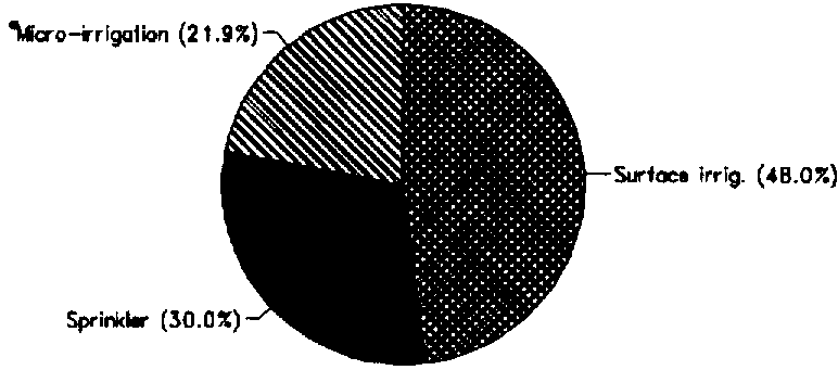
| 1. Full or partial control Irrigation: equipped area | 1992 | 6 142 | ha |
| - surface irrigation | 1992 | 2 950 | ha |
| - sprinkler irrigation | 1992 | 1 845 | ha |
| - micro-irrigation | 1992 | 1 347 | ha |
| % of area irrigated from groundwater | 1992 | 14.4 | % |
| % of area irrigated from surface water | 1992 | 85.6 | % |
| % of equipped area actually irrigated | 1992 | 100 | % |
| 2. Spate irrigation area | - | ha | |
| 3. Equipped wetland and inland valley bottoms | - | ha | |
| 4. Other cultivated wetland and inland valley bottoms | - | ha | |
| 5. Flood recession cropping area | 1992 | 2 000 | ha |
| Total water managed area (1 + 2 + 3 + 4 + 5) | 1992 | 8 142 | ha |
| - as % of cultivated area | 1992 | 4.0 | % |
| - increase over last 10 years | - | % | |
| - power irrigated area as % of water managed area | 1992 | 44.8 | % |
| Full or partial control schemes: | Criteria | ||
| Large schemes | > - ha | - | ha |
| Medium schemes | - | ha | |
| Small schemes | < - ha | - | ha |
| Total number of households in irrigation | 1992 | 550 | |
| Irrigated crops: | |||
| Total irrigated grain production | 1992 | 50 000 | t |
| as % of total grain production | 1992 | 43.9 | % |
| Harvested crops under irrigation (full or partial control) | 1991 | 6 142 | ha |
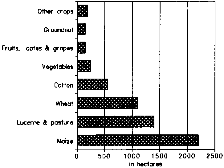
| - maize | 1991 | 2 200 | ha |
| - lucerne & pasture | 1991 | 1 400 | ha |
| - wheat | 1991 | 1 100 | ha |
| - cotton | 1991 | 560 | ha |
| - other | 1991 | 882 | ha |
| Drainage - Environment: | |||
| Drained area | - | ha | |
| as % of cultivated area | - | % | |
| Flood-protected area | 1992 | 0 | ha |
| Area salinized by irrigation | 1992 | 1 300 | ha |
Groundwater resources are estimated at 2.1 km³/year, of which some 0.03 km³/year is used for irrigation purposes.
The total water withdrawal was estimated to be 0.25 km³/year in 1990, and was forecast to rise to 0.29 km³/year in 1995 and to 0.4 km³/year by 2005 (Figure 1). The agricultural water withdrawal of 0.17 km³ in 1990 seems to be an overestimate.
Saline groundwater has been experienced north of the Etosha pan in the Oshana and Oshikoto Regions. The de-salination for drinking purposes of this brackish water is at an experimental stage. There is much concern over the steady lowering of groundwater tables in the country, particularly in the Tsumeb area. Although there are many artesian supplies, the overall losses are not fully understood. Wastewater is re-used at Windhoek. 1.5 to 4.7 million m³/year is treated and fed back into the water supply system.
International Rivers
The common border rivers are:
No agreements have been reached on utilization of water from other common rivers. Namibia, Angola and Botswana have recently agreed to collaborate on utilization of Okavango water, paying particular attention to the major environmental issues of the Okavango Swamp. Namibia is proposing to abstract 0.06 km³ from the Okavango through the development of the Eastern National Water Carrier System for domestic and livestock purposes.
IRRIGATION DEVELOPMENT
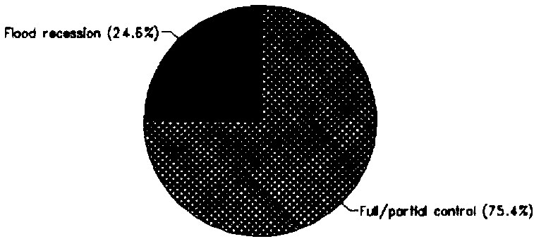
The Total water managed area is 8 142 ha, which includes 2 000 ha of flood recession cropping in the flood plains of the Okavango and Zambezi rivers, mainly planted to maize and using runoff water (15.4 million m³) from Angola (Figure 2).
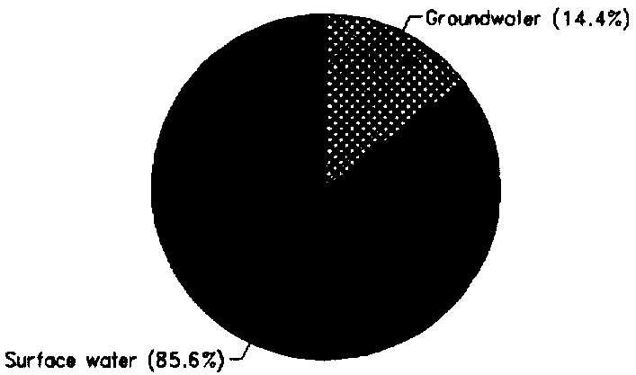
Of the 6 142 ha equipped for irrigation with full or partial control in 1992, some 886 ha (14%) were irrigated from groundwater and 5 256 ha (86%) from surface water, either by pumping from the Okavango and Orange rivers or from storage reservoirs (Figure 3).
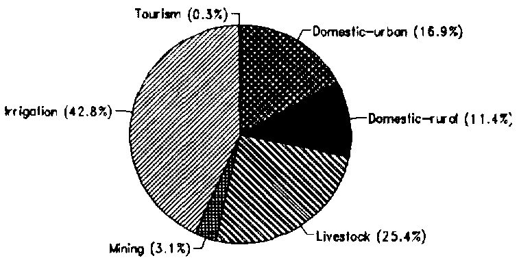
FIGURE 1: Water withdrawal (total: 0.25 km³ in 1990)
The major irrigated crops are maize, lucerne and pasture, wheat and cotton (Figure 4). The irrigation area has increased by some 350 ha between 1991 and 1994. Full or partial control irrigation techniques comprise 2 950 ha under surface irrigation (basin and furrow); 1 845 ha under centre pivot and sprinkler; and 1 347 ha under drip and micro-sprinkler. Layflat hose is also used (Figure 5).
Some 3.6 million ha of land has soil classed as highly suitable for irrigation, but, taking into account water availability, the potential for irrigation development is only 45 000 ha, which is only 1.2% of the irrigable soils. The potential irrigation can be divided into 8 142 ha of already equipped area, 10 000 ha for a sugar cane project in Caprivi, and about 27 000 ha for irrigation development in the rest of the country.
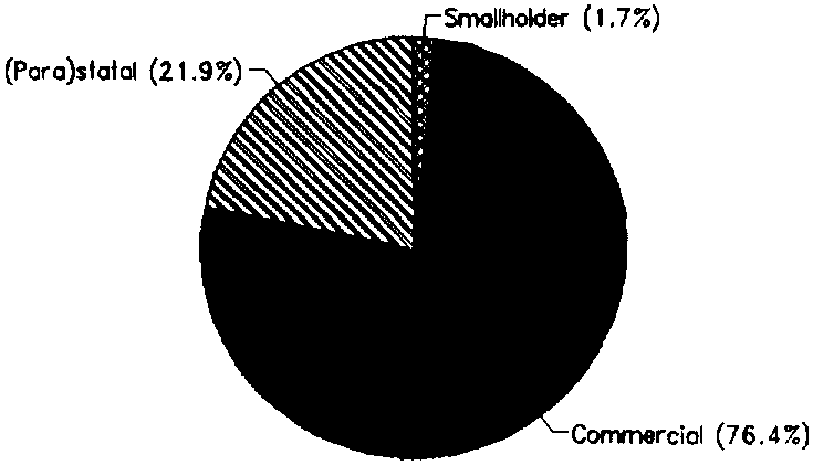
There are four basic categories of farming in the irrigation subsector (Figure 6):
FIGURE 2: Distribution of the water managed areas (1992)
FIGURE 3: Origin of irrigation water, full or partial control (1992)
FIGURE 4: Irrigated crop areas, full or partial control (1990/91)
FIGURE 5: Irrigation techniques, full or partial control (1992)
At present, no water fees are imposed on smallholders or commercial owners who have their own water sources. Where irrigation water is drawn from Water Affairs supplies, such as Hardap, Nante and Owambo, an annual fee of $US 52/ha is charged for the first 15 000 m³/ha and thereafter each additional cubic metre of water per hectare is paid for at a rate ranging from $US 0.0057 to $US 0.042, depending on the total additional quantity used.
INSTITUTIONAL ENVIRONMENT
Responsibility for all irrigation planning and development rests with the Ministry of Agriculture, Water and Rural Development. The Department of Water Affairs within the Ministry has traditionally been responsible for all water resources development projects, including irrigation.
TRENDS IN WATER RESOURCES MANAGEMENT
At the end of 1993, the Government approved an overall Strategy and Policy for the Water and Sanitation Sector. This has now been adopted as policy guidelines for Government. Priority ranking was given to the allocation of water for competing demands:
In all cases where irrigation water is supplied by the State, it is to be charged for at an economic rate, which may be reduced through a special subsidy determined by the value of the produce relative to its socio-economic benefits. On account of the opportunity cost of scarce water resources, there is a trend to focus on the irrigation of high value cash crops rather than fodder crops. However, any change will take time, based on constraints of accessible markets and labour requirements.
FIGURE 6: Irrigation management
Agricultural policy guidelines relating to irrigation have been drafted and were expected to be finalized and approved by the Government at the end of 1994. The policy objectives of the Irrigation Strategy were:
MAIN SOURCES OF INFORMATION
Central Statistic Office. 1991. Population by Regions.
Ministry of Agriculture, Water and Rural Development, Department of Water Affairs. 1991. Perspective on Water Affairs.
Ministry of Agriculture, Water and Rural Development, Department of Water Affairs. 1993a. A Digest of the Water Supply and Sanitation Sector Policy of the Government of Namibia.
Ministry of Agriculture, Water and Rural Development, Department of Water Affairs. 1993b. Central Area Water Master Plan. Phase I. GTZ.
Ministry of Agriculture, Water and Rural Development. 1994. Identification and Prioritization of Irrigation Development Opportunities on the Orange River.
Namibia Early Warning and Food Information System NAM/93/017. 1994. Crop and Food Security Bulletin. Various issues of 1994.
National Planning Commission. 1993. Transitional National Development Plan 1991/921993/94. Windhoek.
SADCC [Southern African Development Coordination Conference]. 1992. Regional Irrigation Development Strategy, Country Report: Namibia.