The ability of the world's natural resources to provide the needs of its growing population is a fundamental issue for the international community. World population continues to grow at 1.6% per annum, and at rates exceeding 3% per annum in many of the least developed countries. At the same time, essential natural resources, such as land and water, are declining both in quantity and quality due to such factors as competition with industrial and urban demands, degradation and pollution.
The basic problem is one of mounting pressure on natural resources. Limits to the productive capacity of land resources are set by climate, soil and landform conditions, and by the use and management applied to the land. Sustainable management of land resources requires sound policies and planning based on knowledge of these resources, the demands of the use to which the resources are put, and the interactions between land and land use.
Answers to the following types of questions provide the basis for policy formulation and land-use planning:
� how is land with different potentials and constraints distributed within the country and in component provinces or districts?
� what uses can be recommended on different types of land in different locations?
� how do potential yields vary among locations, years and seasons?
� what is the balance between population demand and land availability in specified areas, and how does this respond to improvements in inputs or management?
Taken within the context of the objectives of governments and those of land users, this information supports the development of land-use policies and enabling strategies in such specific areas as:
� the provision of appropriate, area-specific, extension information and advice;
� the provision of agricultural inputs, or of relief programmes;
� the setting of agricultural research priorities, and the establishment of networks for agro-technology transfer;
� the formulation of legislation or guidelines to regulate and minimize environmental damage, and the establishment of environmental monitoring;
� the identification of particular development programmes or projects.
FAO has devoted considerable attention to the development of techniques for inventory, evaluation and planning of land resources, both at the global level and through its field programme in regions and individual countries. Comple- tion of the Soil Map of the World at 1:5 000 000 scale, together with a standardized soil classification system (FAO, 1974), provided a stimulus to global and comparative assessments of land resource potential. In 1976 the Framework for Land Evaluation (FAO, 1976) established the conceptual approach and methodological orientation to the assessment of land suitability. The Framework is based on evaluating land conditions according to the specific requirements of defined types of land use. This ecological approach marked a radical departure from previous systems of land resource appraisal, and led to a broad range of applications. Guidelines explaining how the Framework can be applied to rainfed and irrigated agriculture, forestry and extensive grazing have been produced (FAO, 1983; 1984a; 1985; 1991).
The original FAO Agro-ecological Zones Project (FAO, 1978) was an early exercise in the application of land evaluation at a continental scale. The methodology used was innovative in that it characterized tracts of land by quantified information on climate, soils and other physical factors, which are used to predict the potential productivity for various crops according to their specific environmental and management needs. Agro-ecological zones are defined, which have similar combinations of climate and soil characteristics, and similar physical potentials for agricultural production.
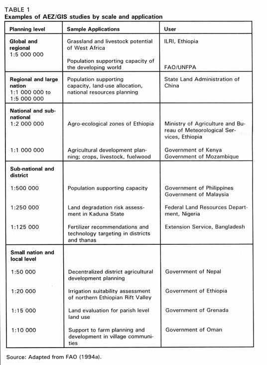
The first series of outputs of the FAO AEZ project were land suitability estimates for 11 crops at three levels of inputs in five regions of the developing world. Subsequently, in cooperation with UNFPA and IIASA, an assessment of potential production and of population support capacity was carried out for the 117 developing nations covered by the project. Following presentation of the findings of this study at the FAO conference in 1983 it was recommended that similar studies be undertaken at national level. Since then, FAO has been assisting various countries, including Mozambique, Kenya, China, Bangladesh, Nepal, Nigeria and Brazil, in learning the methodology, and in applying the results to tackle issues of land, food and people in their component provinces and districts. Still more detailed AEZ investigations have been carried out in selected areas within countries, or on small islands such as Grenada. Some examples of AEZ studies carried out at different scales, and for different purposes, are given in Table 1.
While the AEZ concept is essentially a simple one, the methodology developed by FAO was designed for computers and implemented on them. The nature of the analysis, which involves the combination of layers of spatial information to define zones, lends itself to the application of a geographical information system (GIS). Most advanced AEZ investigations incorporate a series of databases, linked to GIS and dedicated computer models, which have multiple potential applications in natural resource management and land-use planning. Using these techniques, AEZ provides a comprehensive framework for the appraisal and planning of land resources. However, computers are not essential to an AEZ study, and there are many successful examples of application using commercial databases or spreadsheets and conventional cartography.
These guidelines are intended to guide scientists and planners wishing to implement AEZ at the regional, country or sub-national level. Chapter 2 explains the concepts of AEZ and provides definitions of the terms used. Chapter 3 provides a step-wise guide to carrying out an AEZ study, drawing examples from FAO's experience in different environments and different countries, while Chapter 4 discusses computer-assisted techniques, including linkages with GIS. Chapter 5 discusses an alternative, but related, approach to zoning which takes both ecological and economic factors into account.
