![]()
![]()
![]()
GEOGRAPHY AND POPULATION
Kyrgyzstan is a mountainous, landlocked country in Central Asia, bordered on the north by Kazakhstan, in the east and south-east by China, in the south-west by Tajikistan and in the west by Uzbekistan. It became independent in 1991 and has a total area of 198 500 km². About 94% of the country is located at more than 1 000 metres above sea level and 40% above 3 000 metres, covered with glaciers and snow. The highest mountain is Victory Peak (7 429 m), which stands in the immense Mustag massif, one of the world's largest glaciers, covering 1 579 km . To the south are the Pamirs, another towering range of mountains.
In 1990, the cultivated area was estimated at 1.32 million ha, which is almost 7 % of the total area of the country. About 1.28 million ha consisted of annual crops and 40 600 ha consisted of permanent crops. Agriculture is highly mechanized. In 1990, there were 176 collective farms and 290 state farms with about 29 000 tractors.
The total population is about 4.7 million (1995), of which 61 % is rural.
The natural annual demographic growth rate is estimated at 2.2%. However, taking into consideration migration it is estimated at 1.8%. In 1991, 35% of the labour force was engaged in agriculture. In 1994, agriculture accounted for 34% of the country's GDP.
TABLE 1 - Basic statistics and population
| Physical areas. | |||
| Area of the country | 1995 | 19850000 | ha |
| Cultivable area | - | ha | |
| Cultivated area | 1990 | 1323 400 | ha |
| - annual crops | 1990 | 1282 800 | ha |
| - permanent crops | 1990 | 40 600 | ha |
| Population: | |||
| Total population | 1995 | 4 745 000 | inhabitants |
| Population density | 1995 | 24 | inhab./km² |
| Rural population | 1995 | 61 | % |
| Water supply coverage: | |||
| Urban population | 1990 | 86 | % |
| Rural population | 1990 | 75 | % |
CLIMATE AND WATER RESOURCES
Climate
The climate in Kyrgyzstan is of the continental type with hot summers and cold winters, during which frost occurs in all parts of the country. Average annual precipitation is estimated at 316 mm, varying from 150 mm in the plains to over 1 000 mm in the mountains.
Water resources
As a result of tens of thousands of years of glaciation, there are some 3 000 lakes (many of which are located at an elevation of over 3 000 metres), continuously filled by rivers flowing down from the mountains. Average natural surface water flow in the country is estimated at 47.23 km³/year, all internally produced, of which 28.97 km³ or 61% flows through the Amu Darya and Syr Darya that drain into the Aral Sea. Of these 47.23 km³/year, the former Soviet Unionallocated 11.60 km to Kyrgyzstan, while the rest was allocated to the surrounding republics of Kazakhstan, Uzbekistan, Turkmenistan and Tajikistan. This allocation is apparently still endorsed by the five states of Central Asia. Out of the Kyrgyzstan allocation, 5.30 km originate from the Amu Darya and Syr Darya. Fresh groundwater resources, usually of very high quality, have been estimated at 13 km³/year and constitute the baseflow of surface runoff.
TABLE 2 - Water: sources and use
| Renewable water resources: | |||
| Average precipitation | 316 | mm/yr | |
| 62.73 | km³/yr | ||
| Internal renewable water resources | 47.23 | km³/yr | |
| Total (actual) renewable water resources | 1995 | 11.60 | km³/yr |
| Dependency ratio | 1995 | 0 | % |
| Total {actual} renewable water resources per inhabitant | 1995 | 2 445 | m³/yr |
| Total dam capacity | 1990 | 21500 | 106 m³ |
| Water withdrawal: | |||
| - agricultural | 1990 | 10 465 | 106 m³/yr |
| - domestic | 1990 | 259 | 106 m³/yr |
| - industrial | 1990 | 312 | 106 m³/yr |
| Total water withdrawal | 11 036 | 106 m³/yr | |
| per inhabitant | 1990 | 2 527 | m³/yr |
| as % of total (actual) renewable water resources | 95.1 | % | |
| Other water withdrawal | 1990 | 137 | 106 m³/yr |
| Average groundwater depletion | - | 10 6m³/yr | |
| Wastewater - Non-conventional water sources: | |||
| Wastewater: | |||
| - produced wastewater | 1990 | 115 | 106 m³/yr |
| - treated wastewater | 1990 | 11 | 106 m³/yr |
| - reused treated wastewater | 1990 | 9 | 106 m³/yr |
| Desalinated water | - | 106 m³/yr | |
Dams
In 1990, total dam capacity was 21.5 km³. The largest dam is the Toktogul dam on the Syr Darya river with a reservoir capacity of 19.5 km³. However, due to its location downstream near the border with Uzbekistan. it does not play an important role in the irrigation of areas within Kyrgyzstan. The same applies to the Kirov dam which has a capacity of 0.55 km .
Water withdrawal
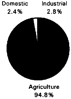
In 1990, total water withdrawal was about 11 km³, which is almost the total allocation of Kyrgyzstan (11.6 km³/year) (Figure 1). Average annual surface water availability for irrigation during the period 1985-1992 was about 10.77 km³, although the water requirement had been evaluated at 10.83 km³, leading to an irrigation water deficit for the whole country of 0.06 km³. However, in some provinces there is a fairly severe water shortage, while in other provinces there is a surplus. Surface water is mainly used for irrigation purposes, while groundwater is mainly used for domestic and industrial purposes.
Figure 1 - Water withdrawal (total: 11.036 km³ in 1990)
TABLE 3 - Irrigation and drainage
| Irrigation potential | 1990 | 2247300 | ha |
| Irrigation: | |||
| 1. Full or partial control irrigation: equipped area | 1990 | 1072600 | ha |
| - surface irrigation | 1990 | 931 588 | ha |
| - sprinkler irrigation | 1990 | 141 000 | ha |
| - micro-irrigation | 1990 | 12 | ha |
| % of area irrigated from groundwater | 1990 | 0.2 | % |
| % of area irrigated from surface water | 1990 | 99.8 | % |
| % of area irrigated from non-conventional sources | 1990 | 0.0 | % |
| % of equipped area actually irrigated | - | % | |
| 2. Spate irrigation area | - | ha | |
| 3. Equipped wetland and inland valley bottoms (i.v.b.) | - | ha | |
| Total irrigation (1 +2+3) | 1990 | 1072600 | ha |
| - as % of cultivated area | 81 | % | |
| 4. Flood recession cropping area | - | ha | |
| Total water managed area (1 + 2 +3 +4) | 1990 | 1072600 | ha |
| - as % of cultivated area | 81 | % | |
| - increase over last 10 years | - | % | |
| - power irrigated area as % of water managed area | - | % | |
| Full or partial control irrigation schemes: Criteria | |||
| Large-scale schemes > 5 000 ha 1990 | 643 200 | ha | |
| Medium-scale schemes | 1990 | 229 400 | ha |
| Small-scale schemes < 1 000 ha | 1990 | 200 000 | ha |
| Total number of households in irrigation | 1990 | 705 825 | |
| Irrigated crops: | |||
| Total irrigated grain production | - | tons | |
| as % of total grain production | - | % | |
| Harvested crops under irrigation (full or partial control) | - | ha | |
| - permanent crops: total | - | ha | |
| - annual crops: total Environment: | - | ha | |
| . fodder crops (perennial and annual) | 1992 | 396 900 | ha |
| . cereals | 1992 | 288 300 | ha |
| . vegetables (including potatoes) | 1992 | 27 800 | ha |
| . cotton, tobacco | 1992 | 40 900 | ha |
| . other annual crops | - | ha | |
| Drainage - Environment: | |||
| Drained area | 1990 | 149 200 | ha |
| as % of cultivated area | 11 | % | |
| - drained areas in full or partial control irrigated areas | - | ha | |
| - drained areas in equipped wetland and i.v.b | - | ha | |
| - other drained areas | - | ha | |
| - total drained area with subsurface drains | - | ha | |
| - total drained area with surface drains | - | ha | |
| Flood-protected area | - | ha | |
| Area salinized by irrigation | 1993 | 123 400 | ha |
| Population affected by water-borne diseases | - | inhabitants | |
IRRIGATION AND DRAINAGE DEVELOPMENT
Irrigation is a key input into the agricultural sector of Kyrgyzstan, reaching over 80% of the cultivated area. It has also been critical in m`intaining and stabilizing agricultural production. Irrigation potential has been estimated at about 2.25 million ha. In 1990, the total water managed area, all equipped for fully or partially controlled irrigation, was estimated at 1.07 million ha, which is almost 48 % of the irrigation potential.
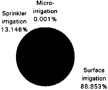
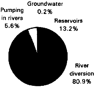
Sprinkler irrigation is practiced on 141000 ha and only 12 ha of micro-irrigation are reported. On the remaining part, representing 87 % of the total area, surface irrigation methods are used (Figure 2). Out of the total irrigated area, only 20% has dependable water either from storage dams or groundwater. The remaining 80% is supplied through the diversion of mountain streams (Figure 3).
The main systems, particularly those downstream of large storage dams, are well maintained. However, the distribution systems within the state and collective farms are generally poorly designed, built and maintained. Seepage and leakage losses in the distribution system are considerable, resulting in a conveyance/distribution efficiency estimated at 55 %.
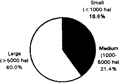
In 1990, there were in total 1 346 irrigation schemes, the characteristics of which are presented in the table below.
Characteristics of the irrigation schemes
| Size | Number of schemes | Total area of schemes (ha) | Average area of scheme (ha) | Number of beneficiaries | Number of benefic./ha |
| Small ( < 1000 ha) | 1 174 | 200 000 | 170 | 486 400 | 2.4 |
| Medium (1000-5000 ha) | 101 | 229 400 | 2 270 | 648 400 | 2.8 |
| Large (>5000 ha) | 71 | 643 200 | 9 060 | 1 688 500 | 2.6 |
| Total | 1 346 | 1 072 600 | 800 | 2 823 300 | 2.6 |
Figure 2 - Irrigation techniques f/p (total: 1 072 600 ha in 1990)
Figure 3 - Origin of irrigation water f/p (total: 1 072 600 ha in 1990)
Figure 4 - Typology of f/p control irrigation schemes (total: 1 072 600 ha in 1990)
Large schemes represent 60 % of the irrigated area (Figure 4). They are state or collective farms. With the government programme to privatize agricultural production it is expected, however, that the number of small-scale farms (even less than 50 ha) will increase considerably.
The average cost of irrigation development varies from $US 1 080/ha for small schemes to $US 2 340/ha for medium schemes and $US 3 530/ha for large schemes. Average annual operation and maintenance costs are estimated at $US 26, 55 and SO/ha respectively.
In the past years, farmers were not charged for water, although the land tax is two or three times higher on irrigated land than it is on non-irrigated land of similar quality. However, the financial situation has changed dramatically and the Ministry of Irrigation (MOI) is no longer able to cover irrigation costs by general tax revenues. In 1992-93, a water fee was imposed on state and collective farms, a service charge for delivering water. Only 20-30% of the farms paid the fee. According to the draft budget for 1995, water users would have to pay 78% of the maintenance costs of the irrigation system through this water fee and the state budget would pay 22 %. Over half the equipped area is said to need rehabilitation.
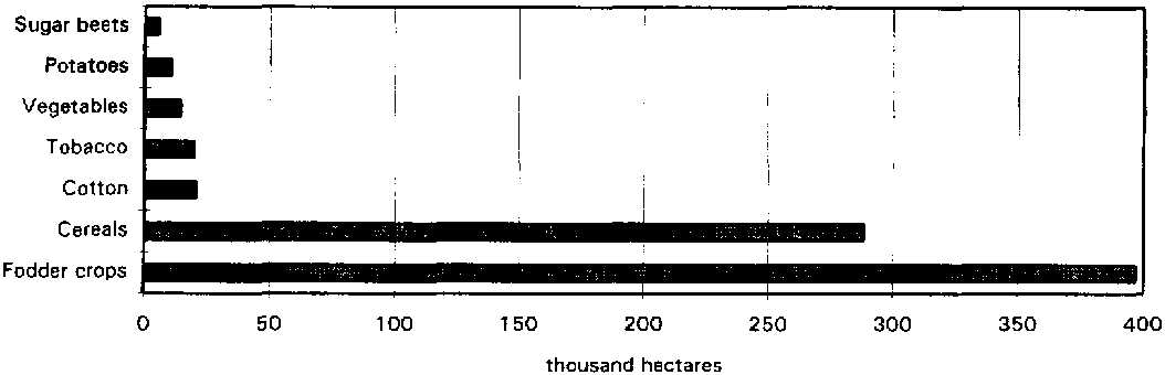
The major irrigated crops are fodder crops and cereals (Figure 5). Although yields are generally low for irrigated land by world standards, they are about five times higher than yields in nonirrigated areas.
Waterlogging, drainage and salinity problems
In 1993, 123 400 ha had salinity problems, of which 63 400 ha were slightly saline, 34 200 ha moderately saline and 25 800 ha highly saline. The waterlogged area was estimated at 89 200 ha in 1990, while the drained lands amounted to 149 200 ha.
Salinity and drainage problems are likely to increase in the near future. With the very restricted budget facing MOI, it is unlikely that it will be able to maintain and operate the existing drainage system effectively, nor improve or extend it. Most drainage and salinity problems are in the northern part of the country, in the Chui province.
Figure 5 - Major irrigated crops in 1992
INSTITUTIONAL ENVIRONMENT
The Ministry of Water Resources/Economy and the Ministry of Agriculture are the main institutions involved in water resources, irrigation and drainage planning and development.
In the past, irrigation systems were designed and operated to deliver water to the large state or collective farms and it was a relatively easy task for MOI to deliver water to each farm. However, the increasing number of small farms following the privatization programmes, will need new legal institutions to interface with the farmers and provide adequate support.
Article 18 of the new water law includes specific provisions for establishing water users associations that receive water from MOI and allocate it among members of the association, many of whom will be farmers. They would have legal standing, be independent of the government, and be able to collect taxes from their members, borrow funds, and take appropriate action to maintain and upgrade 'their' part of the irrigation system, which are the on-farm systems formerly operated by the state and collective farms.
TRENDS IN WATER RESOURCES MANAGEMENT
According to the agricultural sector review of the World Bank (1995) the following three key issues need immediate attention to secure the sustainability of irrigation in Kyrgyzstan.
MAIN SOURCES OF INFORMATION
World Bank. 1993. Kyrgyzstan: The transition to a market economy. A World Bank Country Study. Washington D.C.
World Bank. 1995. The Kyrgyz Republic: Agricultural Sector Review. Report No 12989KG. Washington D.C.
![]()
![]()
![]()