![]()
![]()
![]()
GEOGRAPHY AND POPULATION
The Maltese Archipelago is located in the central part of the Mediterranean Sea about 90 km south of Sicily (Italy), 300 km east of Tunisia and 350 km north of Libya. It consists of 3 main islands, Malta, Gozo and Comino some islets (Cominotto, Filfla) without inhabitants.
The total area of the archipelago is 316 km². The available agricultural land has steadily decreased during recent decades, due to urban and tourist development. Between 1983 and 1991 it decreased by almost 7% from 11491 ha to 10 721 ha. All available agricultural land is cultivated. Pressures are also heightened on already overcharged infrastructures such as water and electricity by the presence of more than 1 million tourists a year.
TABLE 1 - Basic statistics and population
| Physical areas: | |||
| Area of the country | 1995 | 31 600 | ha |
| Cultivable area | 1991 | 10 721 | ha |
| Cultivated area | 1991 | 10 721 | ha |
| - annual crops | 1991 | 10 091 | ha |
| - permanent crops | 1991 | 630 | ha |
| Population: | |||
| Total population | 1995 | 366000 | inhabitants |
| Population density | 1995 | 1158 | inhab./km² |
| Rural population | 1995 | 11 | % |
| Water supply coverage: | |||
| Urban population | 1995 | 100 | % |
| Rural population | 1995 | 100 | % |
The total population is 366 000 (1995), of which 11% is rural. With a population density of 1 158 inhabitants/km² it is one of the most densely populated countries in the world. About 2% of the labour force are full-time farmers and another 15% are part-time farmers. The rural population is decreasing because of a reduction in the number of full-time farmers and a preference for urban settlement. On the other hand, old and abandoned farmhouses are being reinstated or converted to residential farmhouses by non-farming families who prefer to live in the countryside. In 1993, agriculture, including fishing, accounted for only 3% of GDP.
CLIMATE AND WATER RESOURCES
Climate
Due to its geographical location the archipelago enjoys a typical Mediterranean climate characterized by hot, dry summers and mild, humid winters. The rainy season is between September and March with the last rain in April. Average annual rainfall is around 524 rnrn and the temperature varies between 7°C and 15°C in January to between 25°C and 35°C in August. A record temperature of 42°C was recorded in August 1995.
Water resources
Despite the relatively low rainfall and the arid appearance of the Maltese Islands, local catchment characteristics are very favourable for the storage of rainwater and the hydrological cycle provides a generous supply of freshwater which undoubtedly contributed to the early settlement of the inhabitants.
TABLE 2 - Water: sources and use
| Renewable water resources: | |||
| Average precipitation | 524 | mm/yr | |
| 0.1656 | km³/yr | ||
| Internal renewable water resources | 0.0155 | km³/yr | |
| Total (actual) renewable water resources | 1995 | 0.0155 | km³/yr |
| Dependency ratio | 1995 | 0 | % |
| Total (actual) renewable water resources per inhabitant | 1995 | 42 | m³/yr |
| Total dam capacity | 1993 | 0.154 | 106 m³ |
| Water withdrawal: | |||
| - agricultural | 1995 | 6.6 | 106 m³/yr |
| - domestic | 1995 | 48.6 | 106 m³/yr |
| - industrial | 1995 | 0.5 | 106 m³/yr |
| Total water withdrawal | 55.7 | 106 m³/yr | |
| per inhabitant | 1995 | 152 | m³/yr |
| as % of total (actual) renewable water resources | 359 | % | |
| Other water withdrawal | - | 106 m³/yr | |
| Average groundwater depletion | 1995 | 17.92 | 106 m³/yr |
| Wastewater - Non-conventional water sources: | |||
| Wastewater: | |||
| - produced wastewater | 1991 | 23.7 | 106 m³/yr |
| - treated wastewater | 1993 | 1.8 | 106 m³/yr |
| - reused treated wastewater | 1993 | 1.6 | 106 m³/yr |
| Desalinated water | 1995 | 31.4 | 106 m³/yr |
Surface water resources
Total surface water resources are estimated at 0.5 million m³/year. Structurally, Malta tilts gently to the east giving rise to a topography that is high along the western shores and gently slopes down to sea level along the eastern shores. This implies that the surface drainage lines cross the entire width of the island from their source close to the western shore before reaching the sea on the east. This favourable topography, combined with the good water storage capacity of the soil, excellent infiltration characteristics and effective runoff interception by numerous dams and cisterns, gives the surface water maximum time to seep into the ground and thus minimizes runoff losses to the sea. A greater amount of surface runoff, however, is lost from urban areas via sewers or directly to the sea especially in coastal towns and villages. Attempts are in hand to tackle the storm water wastage problem for a more effective use of surface runoff.
Morphologically, the Maltese Islands are divided into two main units by the Victoria Lines fault, that crosses the northern part of the island of Malta from west to east. North of this fault, Malta is broken up into a number of horsts and grabens by less pronounced faults. Drainage is parallel to the general strike of the horst-graben system and the few intermittent streams flow into the bays to the north-east. The second morphologic unit lies south of the Victoria Lines fault, where two main drainage systems are found. The main one converges into the Valletta basin by a system of east- or north-east-trending streams, while the second one converges into Marsaxlokk bay to the south-east.
Groundwater resources
The renewable groundwater potential on the Maltese Islands is estimated as being approximately 40 million m³/year. In order not to deplete the storage capacity of the main aquifer without causing salt water intrusion, only 15 million m³/year of groundwater would be potentially extractable. Based on the 1995 figures of the Water Services Corporation, however, 19.75 million m³/year were extracted from 13 pumping stations, approximately 160 boreholes in Malta and Gozo, and about 2800 registered private wells (the latter extracting an estimated total of 2.44 million m³/year). This means that groundwater depletion does in fact take place. Moreover, there is significant extraction from illegal and unregistered wells (probably up to 2.97 million m³/year), leading to a total groundwater extraction of 22.72 million m³/year.
TABLE 3 - Irrigation and drainage
| Irrigation potential | 1995 | 2 000 | ha |
| Irrigation | |||
| 1. Full or partial control irrigation: equipped area | 1990 | 763 | ha |
| - surface irrigation | 1990 | 113 | ha |
| - sprinkler irrigation | 1990 | 150 | ha |
| - micro-irrigation | 1990 | 500 | ha |
| % of area irrigated from groundwater | 1990 | 63.3 | % |
| % of area irrigated from surface water | 1990 | 0.0 | % |
| % of area irrigated from non-conventional sources | 1990 | 36.7 | % |
| % of equipped area actually irrigated | 1990 | 94.8 | % |
| 2. Spate irrigation area | - | ha | |
| 3. Equipped wetland and inland valley bottoms (i.v.b) | - | ha | |
| Total irrigation (1+2+3) | 1990 | 763 | ha |
| - as % of cultivated area | 7 | % | |
| 4. Flood recession cropping area | - | ha | |
| Total water managed area 11+2+3+4) | 1990 | 763 | ha |
| - as % of cultivated area | 7 | % | |
| - increase over last 10 years | - | % | |
| - power irrigated area as % of water managed area | - | % | |
| Full or partial contra irrigation schemes: Criteria | |||
| Large-scale schemes = 280 ha | 1990 | 280 | ha |
| Medium-scale schemes | 1990 | 0 | ha |
| Small-scale schemes < 3 ha | 1990 | 483 | ha |
| Total number of households in irrigation | 1990 | 3 000 | |
| Irrigated crops: | |||
| Total irrigated grain production | 1990 | 0 | tons |
| as % of total grain production | 1990 | 0 | % |
| Harvested crops under irrigation (full or partial control) | 1990 | 1 807 | ha |
| - permanent crops: total | 1990 | 0 | ha |
| - annual crops: total | 1990 | 1 807 | ha |
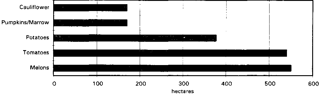
| . melons | 1990 | 550 | ha |
| . tomatoes | 1990 | 540 | ha |
| . potatoes | 1990 | 377 | ha |
| . pumpkins/marrow | 1990 | 170 | ha |
| . cauliflower | 1990 | 170 | ha |
| Drainage - Environment: | |||
| Drained area | - | ha | |
| as % of cultivated area | - | % | |
| - drained areas in full or partial control irrigated areas | - | ha | |
| - drained areas in equipped wetland and i.v.b | - | ha | |
| - other drained areas | - | ha | |
| - total drained area with subsurface drains | - | ha | |
| - total drained area with surface drains | ha | ||
| Flood-protected area | - | ha | |
| Area salinized by irrigation | - | ha | |
| Population affected by water-borne diseases | - | inhabitants | |
Dams
Most runoff occurs after heavy torrential rain. This is the only time when surface water flows, for a few days at most, along the beds of the major valleys. To retain this storm discharge, a large number of small dams have been constructed across the drainage lines. They also serve the purpose of reducing the rate of soil erosion. Open reservoirs have been constructed along recently made roads to minimize runoff. Total dam capacity is estimated at 154 000 m³.
Desalinated water and treated wastewater
At present 31.4 million m³/year of desalinated water are being produced from four sea water Reverse Osmosis Plants and one brackish water Reverse Osmosis Plant, but this is a rather expensive procedure. In 1993, of the total produced wastewater estimated at 23.7 million m³, about 1.82 million m³ was treated and 1.56 million m³ of this was reused.
Water withdrawal
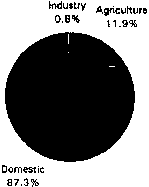
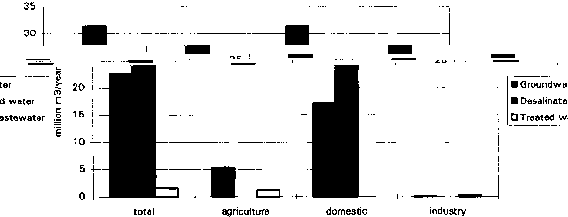
Total water withdrawal, was estimated at 55.68 million m³ in 1995, of which 87% for domestic purposes (Figure 1). Of the total quantity of groundwater used (22.72 million m³), 17.20 million m³ were used for domestic purposes, 5.41 million m³ for agricultural and the remaining 0.11 million m³ for industrial purposes. The desalinated water (31.40 million m³) was all used for the provision of potable water in the public supply, which is equal to 65% of the total potable water supply. Of the total reused treated wastewater (1.56 million m³); 1.22 million m³ was reused in agriculture and 0.34 million m³ in industry (Figure 2).
Figure 1 - Water withdrawal (total: 55.68 million m³ in 1995)
Figure 2 - Origin of water used by sector (total: 55.68 million m³ in 1995)
IRRIGATION AND DRAINAGE DEVELOPMENT
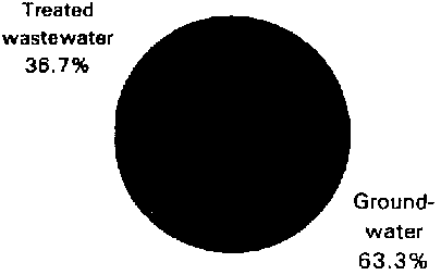
In 1990, the total water managed area, all equipped for full or partial control irrigation, was estimated at 763 ha, which is about 7% of the agricultural land. Of this area, 280 ha are equipped for irrigation by treated sewage water from a sewage treatment plant (Figure 3), which was completed in 1983 to provide 7 000 m³ water per day, but at present 240 ha are actually irrigated per year using 1.22 million m³ of treated wastewater. Tenders have been issued to upgrade this sewage treatment plant to produce 17 000 m³ per day for irrigation and industrial purposes. Work is expected to be completed by early 1997.
Figure 3 - Origin of irrigation water f/p (total: 763 ha in 1995)
Plans are also under way to construct three other sewage treatment plants, two in Malta and one in Gozo, with a total capacity of 73 000 m³ per day to treat all the sewage produced in the country by the year 2000. Hence the total available treated wastewater would be about 90 000 m³ per day. Since the maximum daily irrigation water requirements are estimated at 60 m /ha per day (July/August), the potential area for irrigation from treated wastewater would be 1 500 ha if all the wastewater was reused for irrigation. The potential area to be irrigated from treated wastewater could even be increased up to 2 500 ha if wastewater could be stored in winter (when irrigation water requirements are lower) for use during the summer. However, this solution is financially prohibitive. Thus, the total irrigation potential is estimated at 2 000 ha, of which 500 ha irrigated by groundwater and 1 500 ha irrigated by treated wastewater. Nevertheless, there are several limitations to reaching this potential including fund availability, problems of access to the fields, the size and fragmentation of farm holdings, farm labour demand, marketing, water charges and the Groundwater Protection Zones. From preliminary cost estimates of water distribution networks to supply treated wastewater to farmers from the new sewage treatment plants, the capital investment required would amount to $US 11 000/ha.
According to the Agricultural Census, 483 ha is the area actually irrigated by groundwater, while the Water Services Corporation (WSC) recorded an area of only about 269 ha irrigated by groundwater. The difference can be explained by looking at the history of groundwater extraction in Malta. Groundwater abstraction is administered and regulated by WSC and the law states that nobody is allowed to sink shafts to exploit the groundwater since this is used as potable water. However, before this legislation, which was enacted in 1943, several farmers had sunk shafts to abstract water. The thousands of sunk shafts are the property of the farmers themselves and though, under the law, the abstraction of water is controlled by WSC, the shafts are administered individually by farmers. Each shaft may irrigate only a hectare or two, depending on the area cultivated by the farmer when the shaft was sunk some 60 or 70 years ago. But individual records of present water abstraction are not kept and these shafts are scattered over all rural areas, but predominantly in the north of the country. The number of private wells officially registered by WSC is about 2800, to which an important number of unregistered wells should be added. Total groundwater withdrawal from the wells is estimated at 5.41 million m³/year, of which 2.44 million m³ extracted by registered wells and an estimated 2.97 million m /year by unregistered wells.
Apart from the treated wastewater and groundwater used for irrigation, water harvesting practices are also widely spread all over the islands. Throughout the centuries, several farmers have built or dug small reservoirs in the rock to collect rainwater to be used mainly as supplementary irrigation. Recently, several reservoirs with capacities of 100 - 2 000 m³ were constructed for irrigation in spring or early summer, some with financial assistance from the government. Though this water collection may seem insignificant, it is in fact very important to provide a supplementary source of water for Maltese agriculture and it covers an area estimated at 1 953 ha. For example, probably over 1 000 ha of the 1 400 hectares spring potato crop which is planted in the rainy season in December and January, and harvested in May and June, is irrigated with this source of water in the absence of rainfall. Similarly, unquantified large areas of vegetable production may also receive additional irrigation from this surface runoff water from September to early June.
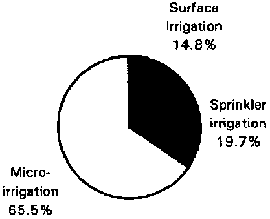
On the areas irrigated by treated wastewater, the distribution network for surface irrigation was originally constructed of concrete channels which created problems and brought complaints from farmers wanting their share of irrigation water. Though a report was drawn up by a consultancy firm to improve this system, funds were never made available to execute the works. Fortunately, the farmers have themselves invested heavily in installing micro-irrigation equipment to irrigate cash crops. Part of the area is also equipped with sprinklers to irrigate potatoes in spring since the potato crop is more responsive to sprinkler irrigation. Out of a total managed area of 763 ha, it is estimated that 500 ha are equipped with micro-irrigation systems, 150 ha with sprinkler irrigation systems, while on the remaining 113 ha surface irrigation is practiced (Figure 4). The cost of irrigation development is in the range of $US 1 600/ha for micro-irrigation, while the operation and maintenance costs are about $US 800/ha per year.
There are three categories of farming in the irrigation subsector and an estimated 3 000 farmers, both full-time and part-time, are involved:
Figure 4 - Irrigation techniques f/p {total: 763 ha in 1995)
The major crops under full or partial control irrigation are melons, tomatoes, potatoes, pumpkins! marrow and cauliflower (Figure 5), with a total cropped area of 1 807 ha (average cropping intensity is 2.5). In addition, the areas benefiting from water harvesting techniques (1953 ha) are generally cropped once a year. With the introduction of micro-irrigation and improved farming practices, the yields of some products significantly increased during the period 1990-95. Yields of melons increased from 6 tons/ha in 1990 to an estimated 20 tons/ha in 1995.
Figure 5 - Irrigated crops f/p (total: 1 807 ha in 1990, crop intensity 2.5)
Revenue from one hectare of fully irrigated land is calculated to be $US 24 750, which is at least ten times the revenue from dry farming. The main reason is that vegetable production during the totally dry period, from May to the end of August, may only be carried out under constant irrigation. Moreover, owing to favourable temperatures, with full irrigation a cropping intensity of 3 may be achieved. In the case of treated wastewater irrigation scheme, cropping intensity averages about 2.
Drainage is not practiced in Malta since infiltration rates are high, averaging 74 mm/hr. The few small wetland areas adjacent to the sea have been declared conservation areas, two of which are bird sanctuaries.
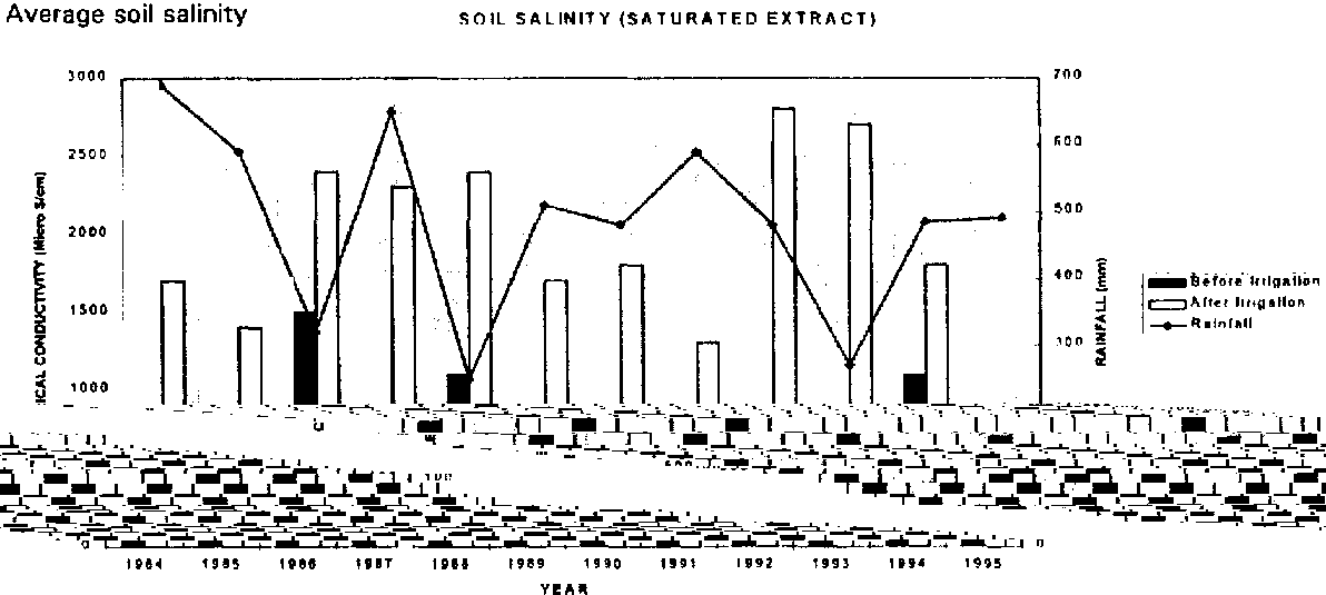
There are no salinization problems since any salt accumulation in the top layer of the soil is washed down through the shallow soils with regular frequent irrigation and torrential rains in the winter. Figure 6 shows clearly that any salt accumulation as a result of irrigation with 4 000 µs/cm wastewater during the dry summer is removed during winter by torrential rains. Moreover both groundwater aquifers are deep and do not rise to the top soil.
Figure 6 - Average soil salinity
INSTITUTIONAL ENVIRONMENT
The two main institutions involved in water resources management are:
The Ministry of the Environment:
The Ministry of Food, Agriculture and Fisheries:
TRENDS IN WATER RESOURCES MANAGEMENT
As a consequence of the groundwater depletion, a steady salinization of the groundwater sources has taken place over the last 20 years. For this reason, other alternative water supplies, like desalinated sea water and treated wastewater, will have to continue to be adopted so as to stop and reverse this depletion..
The commitment of Malta to treat all sewage water produced by the year 2000 would make treated wastewater available to irrigate about 1 500 ha, in addition to 500 ha irrigated by groundwater. However, the main constraints to achieving this potential are the funding of the irrigation network, realistic water charges and marketing prices.
Domestic use of groundwater has top priority and hence further development of this source for irrigation is very limited. Through a more efficient use of water by means of micro-irrigation, there would be great potential for an expansion in irrigated areas. The government is financially assisting farmers to buy irrigation equipment by offering grants and subsidizing interest rates under the Financial Assistance Policy.
MAIN SOURCES OF INFORMATION
BRGM. 1992. Study of the fresh water resources in Malta. Report for the Water Services Corporation.
Central Office of Statistics. 1995. Maltese population estimates 1971-94 and Census of agriculture 199091.
Cowiconsult. 1992. Sewerage Master Plan for Malta and Gozo. Ministry of the Environment.
FAO. 1992. Malta agricultural policy and the E.C. membership challenges and opportunities. Report prepared by Van As, I. and Quick, D.
Gauci, Vince. 1994. Sewage effluent production 1993. Annual report, Waste Recycling Department.
Mitschoff, Josef. 1990. Upgrading and modernization of Sant'Antnin sewage effluent irrigation system. Ministry for Development of Infrastructure.
Water Services Corporation. 1996. Annual Report 1995.
![]()
![]()
![]()