![]()
![]()
![]()
L.R. Oldeman, International Soil Reference and Information Centre (ISRIC),
Wageningen. Netherlands
Since its establishment in 1966, the International Soil Reference and Information Centre (ISRIC), under its mandate:
"to collect and disseminate scientific knowledge about soils for the purpose of a better understanding of their formation, characterization, classification, distribution, and capability for sustained land utilization at local, national and global scales",
prepared a number of national, continental and global soil profile databases and spatially georeferenced soil and terrain databases for a wide range of applications and users (Batjes et al., 1994).
These databases are known under the following acronyms:
|
ISIS: |
ISRIC Soil Information System |
|
WISE: |
World Inventory of Soil Emission Potentials |
|
SOTER: |
World Soils and Terrain Digital Database |
Within the framework of the United Nations Environment Programme (UNEP) and in close cooperation with the Food and Agriculture Organization of the United Nations (FAO), ISRIC has coordinated the development of a database on global soil degradation status and is presently preparing a regional database on soil degradation status for South and Southeast Asia:
|
GLASOD |
(Global Assessment of the Status of Human-induced Soil Degradation) |
|
ASSOD |
(Regional Assessment of the Status of Human-induced Soil Degradation in South and Southeast Asia). |
These databases can be used as a baseline for the development of Land Quality State Indicators. The preamble for a series of workshops (1992) initiated by the World Resources Institute and the California Institute of Technology (Global Environmental Monitoring: Pathways to Responsible Planetary Management) states:
"In order to manage our planet's environment rationally, we must understand Earth system processes, obtain a measure of the baseline conditions of Earth Resources, and monitor and report on changes in Earth resources and environmental quality. The SOTER activity of UNEP, FAO and ISRIC plans to use properly structured ground assessments to create a baseline geo-referenced database on soils, soil degradation, and terrain over the next 10-15 years if funds become available. These data would be invaluable to local, and national planners and to those seeking to set priorities for global action and environmental assistance".
TABLE 1. Database status of reference profiles stored in ISIS (December 1994)
|
Country |
ISIS |
Archive |
|
Australia |
3 |
36 |
|
Belgium |
|
4 |
|
Botswana |
7 |
|
|
Brazil |
28 |
1 |
|
Cameroon |
1 |
|
|
Canada |
|
21 |
|
China |
51 |
|
|
Colombia |
18 |
1 |
|
Costa Rica |
12 |
|
|
Côte d'Ivoire |
7 |
|
|
Cuba |
22 |
|
|
Czech Republic |
|
8 |
|
Denmark |
|
8 |
|
Ecuador |
20 |
|
|
Finland |
|
5 |
|
France |
11 |
1 |
|
Gabon |
6 |
|
|
Germany |
14 |
3 |
|
Ghana |
1 |
5 |
|
Greece |
15 |
|
|
Greenland |
1 |
|
|
Hungary |
3 |
16 |
|
India |
12 |
18 |
|
Indonesia |
46 |
|
|
Ireland |
3 |
7 |
|
Italy |
17 |
|
|
Jamaica |
4 |
|
|
Japan |
4 |
|
|
Kenya |
68 |
3 |
|
Malaysia |
18 |
|
|
Malawi |
1 |
|
|
Mali |
8 |
1 |
|
Mozambique |
9 |
|
|
Namibia |
3 |
6 |
|
New Zealand |
|
5 |
|
Nicaragua |
11 |
|
|
Nigeria |
28 |
|
|
Norway |
2 |
1 |
|
Oman |
4 |
|
|
Pakistan |
6 |
|
|
Peru |
21 |
|
|
Poland |
14 |
8 |
|
Philippines |
6 |
|
|
Romania |
11 |
|
|
Rwanda |
10 |
|
|
South Africa |
12 |
9 |
|
Spain |
19 |
|
|
Sri Lanka |
4 |
|
|
Sweden |
5 |
14 |
|
Switzerland |
|
1 |
|
Syria |
|
4 |
|
Thailand |
13 |
|
|
Turkey |
16 |
|
|
United Kingdom |
|
11 |
|
Uruguay |
10 |
|
|
USA |
4 |
21 |
|
former USSR |
2 |
60 |
|
Venezuela |
1 |
|
|
West Samoa |
5 |
|
|
Yugoslavia |
|
3 |
|
Zambia |
11 |
|
|
Zimbabwe |
13 |
|
|
Total (1994) |
652 |
296 |
|
total (1992) |
375 |
440 |
TABLE 2. Global pedon database
|
Broad geographic region |
WISE |
No. of profiles in homogenized database (Int. set) derived from WISE database |
|||
|
FAO |
NRCS |
ISIS |
Total |
||
|
Africa |
1799 |
93 |
204 |
18 |
315 |
|
South, West and Northern Asia |
522 |
24 |
44 |
0 |
68 |
|
China, India, Indonesia, Philippines |
553 |
45 |
129 |
106 |
280 |
|
Australia and Pacific Islands |
122 |
28 |
27 |
0 |
55 |
|
Europe |
492 |
5 |
2 |
0 |
7 |
|
North America |
266 |
14 |
144 |
0 |
158 |
|
Latin America + Caribbean |
599 |
41 |
114 |
86 |
241 |
|
|
4353 |
250 |
664 |
210 |
1124 |
Benites (1995) states that a systematic assessment of sustainability of current and planned land uses is hampered by 1) too many detailed data that are difficult to interpret; 2) no baseline from which to compare change, and 3) data that are inconsistent over time or between geographic areas. In the following section a brief overview is given of the baseline databases prepared or coordinated by ISRIC, in close cooperation with FAO, UNEP, the International Society of Soil Science (ISSS), and national natural resources institutions worldwide.
BASELINE DATA ON SOILS, TERRAIN AND SOIL DEGRADATION STATUS
ISIS
Since ISRIC's establishment in 1966 as an International Soil Museum, soil profiles have been assembled, standard analytical procedures developed, soil samples analysed and associated information collected to illustrate the units of the FAO-UNESCO Soil Map of the World. To facilitate the storage and management of the soil and environmental data collected and analysed, a computerized database management system was developed (ISIS), which has been operational since 1986 (Van Waveren and Bos, 1988). Out of a total of some 950 reference profiles around 650 are now stored in ISIS (Table 1). It is envisaged that by 1997 the ISIS database will be completed. The uniqueness of this database is that all stored information on soil attributes is analysed in a standardized way. The dissemination of the information in ISIS is in the form of hard-copy Country Reports, while selections of the database can be requested in electronic format. Appendix 1 gives an example of the stored information.
WISE
A global soils database, linked through a GIS to the only viable global soil map available (the FAO-UNESCO Soil Map of the World), is now available in digital format with errors corrected and boundary changes included. This database (Table 2) is composed of international datasets held by the Natural Resources Conservation Service (NRCS) of the USA, by FAO, and by ISRIC (i.e. ISIS) and complemented with regional and national databases where and when available. Also included are resources of the ISRIC library collection. Software is available to (mechanically) transfer data held by the major data holders from one database to another. Currently the WISE database contains 4353 profiles (Africa - 1799; South, West, North Asia - 522; China, India, Philippines - 553; Australia and Pacific Islands - 122; Europe - 492; N. America - 266; S. America + Caribbean - 599).
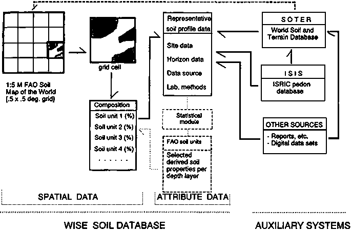
The cartographic database of WISE has been built up mechanically, by identifying soil associations occurring in each 5'x5' grid-cell of the digital version of the World Soil Map, computing the percentage area of each soil unit present in the 36 cells which make up the ½° x ½° grid-cell (Nachtergaele, unpublished data, 1994) using FAO's standard composition rules, and aggregation of information to generate soil geographic area data relevant to each terrestrial ½º x ½º grid-cell. Each of these grid-cells consists of up to ten different soil units (Figure 1, Batjes and Bridges, 1994).
FIGURE 1. Schematic representation of the WISE database
SOTER
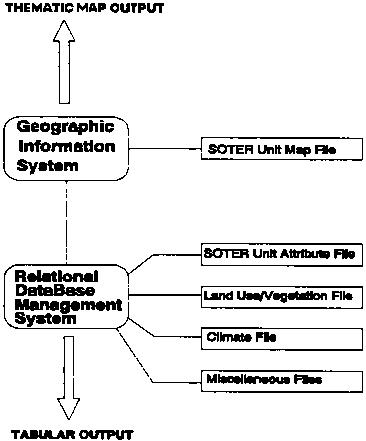
The World Soils and Terrain Digital Database (SOTER) programme provides an orderly arrangement of natural resource data in such a way that these data can be readily accessed, combined and analysed from the point of view of potential use, in relation to food requirements, environmental impact and conservation. Basic in the SOTER approach is the mapping of areas with a distinctive, often repetitive pattern of land form, surface form, slope, parent material and soils. Each area is linked to a geographic information system with a database containing available attributes on topography, land form and terrain, soils, climate, vegetation and land use. In this way each type of information or each combination of attributes can be displayed as a separate layer or overlay or in tabular form.
SOTER is an initiative of the ISSS and the approach was adopted at the 13th World Congress of Soil Science in 1986. The SOTER methodology was developed with UNDP support and in close cooperation with the Land Resources Research Centre of Canada, FAO, and ISSS. After initial testing in three areas, involving five countries (Argentina, Brazil, Uruguay, USA, Canada) the methodology was endorsed by the ISSS Working Group on World Soils and Terrain Digital Database, further refined and in 1993 the Procedures Manual for Global and National Soils and Terrain Digital Databases was jointly published by UNEP, ISSS, FAO and ISRIC, thus obtaining international recognition. The procedures manual is available in English, French, and Spanish.
The SOTER concept was developed for application at a 1:1M scale. However, the methodology can be used at different levels of spatial aggregation. At larger scales subdivisions into smaller sub-units will be necessary (cf. De Oliveira and Van den Berg, 1992). At smaller scales, reduction of the number of attributes is proposed.
In 1992 an international panel to evaluate SOTER was convened by UNEP. The panel recommended not only SOTER activities at national level using scales ranging from 1:500 000 to 1:1M, but also the development of small-scale continental SOTER databases. In 1993 a joint action plan was formulated and jointly financed by UNEP, FAO, and ISRIC to compile a 1:5M SOTER database for Latin America. The SOTER approach applied at scale 1:5M is seen by FAO, UNEP and ISRIC as the formal strategy to replace the Soil Map of the World in the near future (in 2002 at the latest).
The following SOTER databases are completed or currently under construction:
Scale 1:5 million:
¤ Argentina, Brazil (partly), Cuba, Ecuador, Mexico, Uruguay, Venezuela: completed;¤ all other Latin American countries: under construction;
¤ Russia, China and Mongolia, in the framework of the land use and cover change activities of IIASA (under construction);
¤ South and Southeast Asia, as follow-up of the ASSOD activities (under discussion).
Scale 1:1 million:
¤ Argentina (16%), Uruguay, Kenya: completed;
¤ Syria, Jordan: under construction.
Scale 1:500 000:
¤ Hungary: completed.
Scale 1:100 000:
¤ Pilot areas in Argentina, Uruguay: completed.
The SOTER methodology is also being used in Bolivia, Ethiopia, Europe, USA and in North Asia outside the direct involvement of ISRIC. SOTER project proposals have been submitted for funding for China, for Central and Eastern Europe, and for high mountain areas under the Consultative Group on International Agricultural Research (CGIAR) Initiative for Global Sustainable Mountain Development. For further information on the SOTER methodology reference is made to Van Engelen and Wen (1995) and Appendix 2.
GLASOD
In view of UNEP's need for a scientifically credible global assessment of the status of human-induced soil degradation, ISRIC was requested to prepare, in cooperation with over 250 soil scientists worldwide, a world map of the status of human-induced soil degradation at scale 1:15M at the equator (Mercator projection). Regional cooperators were asked to delineate on a standard topographic basemap (derived from the world map of the Institut Geographique National) map units showing a certain homogeneity of physiography, climate, vegetation, geology, soils and land use. Within each delineated map unit, soil degradation types were identified and interpreted for the degree of degradation, their relative extent within the unit and for the type of human intervention that has resulted in soil degradation during the post-war period. The regional results were then generalized and compiled as world map.
As a follow-up activity the GLASOD map was digitized and through a GIS linked to a soil degradation database with attributes derived from its legend. Single value maps on various types of soil degradation and its severity were prepared by UNEP for inclusion in the World Atlas of Desertification. The tabular statistics on extent, degree and causative factors have attracted worldwide attention and were published in the World Resources Report 1992-1993 of the World Resources Institute (WRI, 1992) and were used in IFPRI's 2020 Vision papers (Yadav and Scherr, 1995). Although GLASOD data are based on qualitative expert estimates and provide only a first approximation of the worldwide status of soil degradation, the GLASOD study is according to IFPRI "one of the most cited studies in recent literature on the extent of global soil degradation". More details on GLASOD can be found in Oldeman (1994) and Appendix 3.
At the request of the Steering Committee for the conservation and management of the environment and natural habitats of the Council of Europe an updated version of the European section of GLASOD was prepared (Van Lynden, 1995b).
ASSOD
The third meeting of the Expert Consultation of the Asian Network on Problem Soils (October, 1993) was devoted to the collection and analysis of land degradation data. The consultation recommended to adopt the GLASOD methodology and recognized the need to adopt a physiographic approach in conformity with the SOTER methodology in order to develop national and regional geo-referenced databases to be utilized not only in monitoring soil degradation status but also in estimating key sustainable development factors (FAO, 1994). Under an agreement with FAO a physiographic map and database at 1:5M scale was prepared. The guidelines for soil degradation status assessment were adapted and in late 1994 UNEP supported an Assessment of the status of human-induced soil degradation in South and Southeast Asia, implemented by ISRIC in coordination with national institutions in 16 participating countries and FAO. In ASSOD more emphasis is placed on the assessment of the degree of soil degradation (Van Lynden, 1995a).
Table 3 illustrates how national institutions are asked to derive the degree of soil degradation from the impact on productivity (increase or decrease) in combination with the level of management inputs (e.g., if there is no increase in production despite a major level of management improvements the area is considered to have a moderate degree of soil degradation). During an expert consultation in Manila (November, 1995) ASSOD members expressed the need to prepare more detailed national assessments, to develop a 1:5M SOTER database for the region, and national SOTER databases at larger scales.
THE STATE OF LAND QUALITIES
The databases described in the previous sections form the baseline conditions for the identification of the present or near-present conditions of the land. They can be used to estimate land qualities such as moisture availability, nutrient availability, erosion hazard, flooding hazard, available foothold for roots, conditions for germination, conditions for mechanization, availability of oxygen for root growth, excess of salts, soil toxicities.
TABLE 3. Impact of soil degradation on productivity
|
Level of production increase/decrease |
Level of Input/Management improvements |
||
|
A) Major |
B) Minor |
C) Tradition |
|
|
1) Large increase |
No significant impacts (stable) |
No significant impacts (stable) |
No significant impacts (stable) |
|
2) Small increase |
Light |
No significant impacts (stable) |
No significant impacts (stable) |
|
3) No increase |
Moderate |
Light |
No significant impacts (stable) |
|
4) Small decrease |
Strong |
Moderate |
Light |
|
5) Large decrease |
Extreme |
Strong |
Moderate |
|
6) Unproductive |
Extreme |
Extreme |
Strong to Extreme |
In a pressure-state-response framework baseline information on land conditions is a prerequisite. This will indicate the "inherent", biotic, chemical and physical conditions of the land. These conditions are influenced by outside pressures, which are the normal pressures exerted by natural (climatic) events or those exerted by human activities, depending on the type of land use and land management. As a result the state of the land conditions may change in a negative or positive sense. If the natural resource base is sufficiently stable (or is stabilized) and the pressure exerted on the conditions is balanced by land management inputs, the state of the land conditions may not change at all (sustained utilization of the land). The impact of these changes may lead to a response to halt further degradation or to rehabilitate the degraded land to its initial conditions. In the absence of any response, further pressure may lead to further deterioration of the land conditions, eventually leading to a situation in which the land has lost its productive capacity.
At ISRIC several procedures have been developed to determine the state of the conditions of the land. An ISIS-based procedure has been developed for a qualitative evaluation of the land conditions. This procedure (with acronym STRESS, Mantel and Kauffman, 1995) uses the Automated Land Evaluation System (ALES). It indicates the potential physical suitability of reference soils for low input, arable farming and lists their major limitations, thus enabling the comparison of soils from different parts of the world.
A SOTER-based, automated procedure for qualitative land evaluation is developed (created in ALES). This procedure (acronym SOTAL, Mantel, 1995), provides a methodology that allows quick separation of the potentially suitable SOTER units from those not suitable for an intended land use, and lists constraints for different kinds of land use. SOTAL case studies have been executed in Kenya and Uruguay. The procedure is a useful tool in land-use planning, because constraints for different kinds of land use can be determined quickly. Areas indicated as potentially suitable have no major physical limitations for a proposed land use. For more specific statements, for instance on potentially attainable yield, a quantified land evaluation is needed, using dynamic crop growth simulation models. The attractive feature of the procedure following the pathway of a qualitative land evaluation in SOTAL, preceding a quantified land evaluation, is that non-suitable areas can be neglected in the quantified land evaluation, which demands more data and time.
A SOTER-based programme is developed for the assessment of water erosion hazard (Van den Berg and Tempel, 1995). In this programme (acronym SWEAP), two alternative erosion assessment models, based on SLEMSA (Soil Loss Estimation Model for Southern Africa, developed by Elwell and Stocking, 1982) or the Universal (Soil Loss Equation (USLE), developed by Wischmeyer and Smith, 1978) can be selected. Modifications were introduced in order to adjust the programme to SOTER's facilities and limitations. The aim of SWEAP was to achieve a balance between refinement of the equations and the available information. Results obtained by using SWEAP are in terms of abstract "erosion hazard units", rather than quantified estimates of potential soil loss. SWEAP has been tested in a SOTER pilot area in Canada, in pilot areas in Uruguay and is now being applied in Kenya within the framework of UNEP's programme, "National land degradation assessment and mapping in Kenya".
The GLASOD and ASSOD activities mentioned above provide a qualitative assessment of the status of soil degradation. The approach used in these studies provides indicators for soil degradation state. The estimated impact on productivity of each type of soil degradation is indicated, as well as the "recent past" rate of degradation over the past five to ten years. Although a change in soil and terrain properties may reflect the occurrence and intensity of soil degradation processes, it does not necessarily reflect the seriousness of their impact on overall soil productivity (removal of a 5 cm layer of topsoil has a greater impact on a poor shallow soil than on a deep fertile soil). It would be better to measure the degree of soil degradation by the relative changes of soil properties: the percentage of the topsoil lost, the percentage of total nutrients and organic matter lost; and the relative decrease in soil moisture holding capacity.
Declining productivity as an indicator for soil degradation can also be hazardous because yield declines may arise from factors such as soil degradation, improper management, drought or waterlogging, quality of inputs, pests and diseases. It is therefore important to consider a medium to long period (10-15 years) to level out large aberrations resulting from fluctuations in weather patterns or pest and disease occurrence. On the other hand, soil degradation can be "hidden" by the effects of management measures such as soil conservation techniques, improved availability of external inputs, increased levels of fertilization, better land management. Part of these inputs is used to compensate for productivity losses caused by soil degradation.
In order to indicate the change in degree of soil degradation over time, a qualitative estimate of the trend of soil degradation is given in ASSOD. It is important to know whether a severely degraded area is stable at present, or whether an area that presently has only a slight degree of degradation may show a trend towards rapid further deterioration. At the same time, the ASSOD map will also indicate areas where the situation is improving (for example through soil conservation measures). In this context the project World Overview of Conservation Approaches and Technologies (WOCAT) is worth mentioning.
CONCLUSIONS
Soil and terrain databases form the basis for the assessment of land qualities. Soil degradation databases provide useful indicators of the conditions of the land. Baseline information on the state land qualities is essential to monitor changes in land conditions over time. It would be worthwhile to resample some profiles represented in ISRIC's soil reference collections to determine changes over time. Most of the sites are well-documented and this provides a unique opportunity to study land condition changes as a result of exerted pressures. Another possibility to compare changes over time would be to compare land conditions between areas under natural cover and areas with similar soils but used for agricultural production. To assess the effect of a relative change of soil properties on food productivity, the potential biological productivity of reference soils can be estimated with and without assumed losses of topsoil, or with removal (mining) of nutrients by crops, with and without fertilizer inputs.
REFERENCES
Batjes, N.H. and Bridges, E.M. 1994. Potential emissions of radiatively active gases from soil to atmosphere with special reference to methane: development of a global database (WISE). J. Geogr. Research 99 (08): 16 479-16 489.
Batjes, N.H., van Engelen, V.W.P., Kauffman, J.H. and Oldeman, L.R. 1994. Development of global soil databases for environmental research. Transactions XVth World Congress of Soil Science (Mexico) 6a: 40-57.
Benites, J. 1995. Land conditions change indicators for sustainable land research management. Working Paper, Rpts. 5, (This Volume). FAO/AGLS, Rome. 18 p.
De Oliveira, J.B. and van den Berg, M. 1992. Application of the SOTER methodology to a semi-detailed survey (1:100 000) in the Piracicaba Region (São Paulo State, Brazil). SOTER Report 6. ISSS, Vienna, and ISRIC, Wageningen. 28 p.
Elwell, H.A. and Stocking, M.A. 1982. Developing a simple, yet practical method of soil-loss estimation. Trop. Agric. 59: 43-48.
FAO. 1994. The collection and analysis of land degradation data: report of the Expert Consultation of the Asian Network on Problem Soils, Oct. 1993. RAPA Publ. 1994/3. FAO, Bangkok. 259 p.
Mantel, S. 1995. The Automated Land Evaluation System applied to SOTER with an example from West Kenya. Working Paper and Preprint 95/03. ISRIC, Wageningen. 39 p.
Mantel S. and Kauffman, J.H. 1995. Agricultural suitability of reference soils. The Automated Land Evaluation System applied to ISRIC Soil Information System. Working Paper and Preprint 95/13. ISRIC, Wageningen. 27 p.
Oldeman, L.R. 1994. The Global Extent of Soil Degradation. In: Soil Resilience and Sustainable Landuse. D.J. Greenland and I. Szabolcs (eds.). CAB International, Wallingford. pp. 99-119.
Van Engelen, V.W.P. and Wen, T.T. 1995. Global and National Soil and Terrain Digital Databases (SOTER). Procedures Manual (revised ed.). UNEP, Nairobi; ISSS, Vienna; FAO, Rome; ISRIC, Wageningen. 125 p.
Van Lynden, G.W.J. 1995a. Guidelines for the assessment of the status of human-induced soil degradation in South and Southeast Asia. Working Paper and Preprint 95/02, ISRIC, Wageningen. 20 p.
Van Lynden, G.W.J. 1995b. European soil resources. Current status of soil degradation, causes, impacts and need for action. Nature and Environment No. 71. Council of Europe Press, Strasbourg. 99 p.
Van Waveren, E.J. and Bos, A.B. 1988. ISRIC Soil Information System - User manual. Technical manual. Revised ed. Technical Paper 15. ISRIC, Wageningen. 55 p.
Van den Berg, M. and Tempel, P. 1995. SWEAP: A computer program for water erosion assessment applied to SOTER. SOTER Report No. 7. UNEP, Nairobi and ISRIC, Wageningen. 50 p.
Wischmeyer, W.H., and Smith, D.D. 1978. Predicting rainfall erosion losses. A guide to conservation planning. US Department of Agriculture. Agric. Handbook No. 537, Washington D.C. 58p.
WRI. 1992. Global Environmental Monitoring: Pathways to Responsible Planetary Management. Pasadena, Washington D.C. 17 p.
Yadav, S. and Scherr, S. 1995. Land Degradation in the Developing World: Is it a Threat for Food Production to the year 2020? (Draft paper for workshop on: Land Degradation in the Developing World: Implications for Food, Agriculture and Environment to the Year 2020, 4-6 April, Annapolis, IFPRI, 190 p).
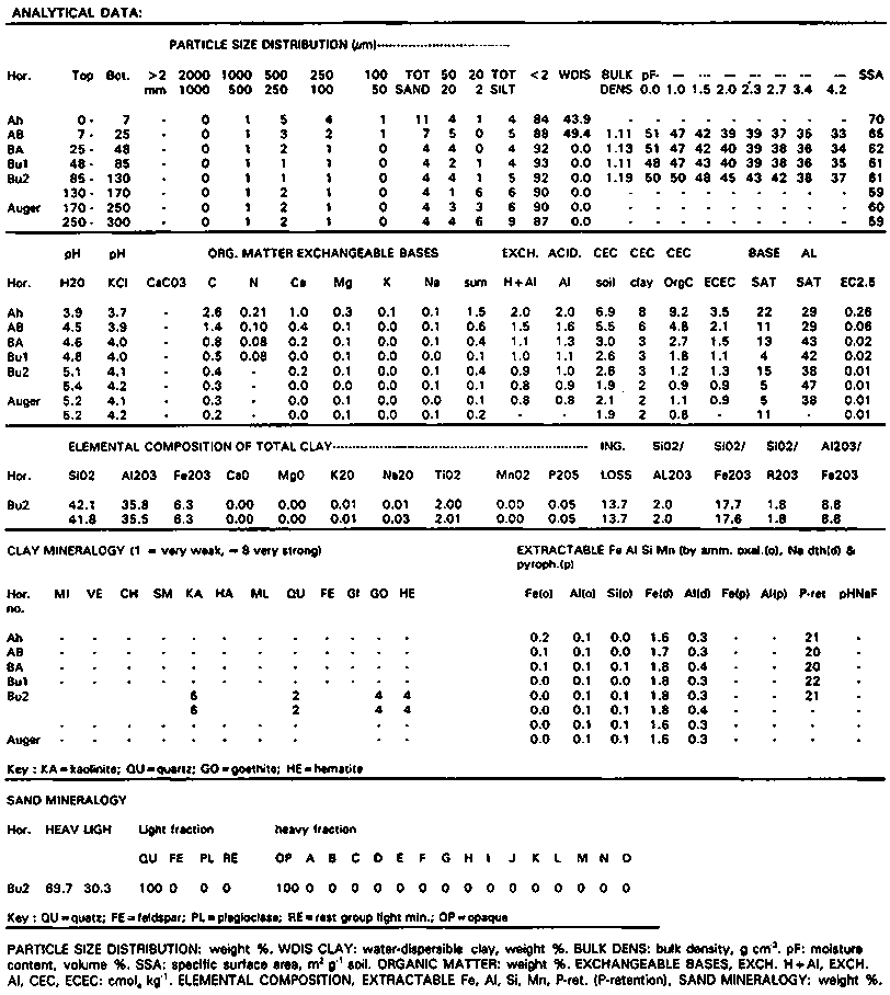
APPENDIX 1
Reference soil BR 1 3, BRAZIL
Print date: 25 July 1995
|
FAO/UNESCO |
(1988) |
: Alumi-Geric Ferralsol | |||
|
|
(1974) |
: Acric Ferralsol | |||
|
USDA/SCS SOIL TAXONOMY |
(1994) |
: Very fine, kaolinitic, isohyperthermic Xanthic Hapludox | |||
|
|
(1975) |
: Haplic Acrorthox | |||
|
LOCAL CLASSIFICATION |
|
: Latossolo amarelo distrófico | |||
|
DIAGNOSTIC CRITERIA |
FAO |
(1988) |
: ochric A, ferralic B horizon, geric properties | ||
|
|
USDA/SCS |
(1994) |
: ochric epipedon, oxic horizon | ||
|
|
Soil moisture regime |
: udic, bordering to ustic | |||
|
|
Soil temperature regime |
: isohyperthermic | |||
|
|
: FAO (1988): geric properties, because ECEC is less than 1.5 cmolc/kg clay. | ||||
|
LOCATION |
: Para State, highway BR 163 (Santarem-Cuiaba) at km 52.2, near Belterra | ||||
|
Latitude/Longitude |
: 2°54'0"S/54°56'0"W |
Altitude |
: 75 m a.s.l. | ||
|
AUTHOR(S) |
: Kauffman, J.H. & J.S. Martins |
Date |
: November 1984 | ||
|
GENERAL LANDFORM |
|
: lacustrine plain, very flat over long distances. | |||
|
|
Topography |
: flat or almost flat | |||
|
PHYSIOGRAPHIC UNIT |
|
: flat plain | |||
|
SLOPE |
Gradient |
: 1% |
Position of site |
: flat | |
|
MICRO RELIEF |
Kind |
: few dispersed small termite mounds at the soil surface | |||
|
SURFACE CHAR. |
Rock outcrop |
: nil |
Cracking |
: nil | |
|
|
Stoniness |
: nil |
Salt |
: nil | |
|
|
Slaking/crusting |
: nil |
Alkali |
: nil | |
|
SLOPE PROCESSES |
Soil erosion |
: slight sheet |
Aggradation |
: not apparent | |
|
|
Slope stability |
: stable |
|
| |
|
PARENT MATERIAL |
Type, texture |
: lacustrine sediments, clayey | |||
|
|
Remarks |
: Belterra clay; geogenesis of the Belterra clay is not very well understood | |||
|
EFFECTIVE SOIL DEPTH |
|
: > 250 cm | |||
|
WATER TABLE |
Kind, depth |
: no watertable observed |
Estimated highest level: 500 cm | ||
|
DRAINAGE |
|
: well | |||
|
|
Drainage remarks |
: no clear surface drainage network present, all surplus precipitation infiltrates to the deeper subsoil and flows laterally through the substratum to the Rio Tapajoz. | |||
|
PERMEABILITY |
|
: high |
| ||
|
FLOODING |
Frequency |
: nil |
Run off: medium | ||
|
MOISTURE CONDITIONS PROFILE |
: 0-250 cm moist | ||||
|
LAND USE |
|
:(semi-) natural vegetation | |||
|
VEGETATION |
Type |
: evergreen forest | |||
|
Land use/vegetation remarks |
: forestry research station; in neighbourhood of site limited wood extraction | ||||
|
ADDITIONAL REMARKS: | |||||
|
CLIMATE: |
Köppen |
: Am | |||
|
MET. STATION |
Name, location |
: BELTERRA, 2°40'S/54°53'W, 31 m a.s.l. | |||
|
|
|
: TAPERINHA (SANTAREM), 2º26'S/54°43'W, 72 m a.s.l. | |||
|
Distance to site (relevance) |
: BELTERRA, 15 km N of the site (good); TAPERINHA (SANTAREM), 90 km ENE of the site (moderate) | ||||
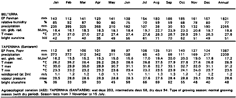
PROFILE DESCRIPTION:
Very deep, well drained brownish yellow clay developed in lacustrine deposits; porous massive, strongly acid and very low in nutrient content and retention. The soil layer from 10 to 50 cm has a faint dark greyish mottled appearance. This mottling is caused by humus which is not well homogenized through the soil.
|
Ah |
0 - 7 cm. |
Brown (10 YR 5/3, moist) clay; weak to moderate fine to very fine subangular blocky to crumb; Sticky, plastic, friable; many very fine and fine pores; common very fine and medium roots; clear smooth boundary to |
|
AB |
7 - 25 cm. |
Yellowish brown (10 YR 5/4, moist) clay; weak subangular blocky to porous massive; sticky, plastic, friable; many very fine and fine pores; few fine and medium roots; gradual smooth boundary to |
|
BA |
25-48 cm. |
Brownish yellow (10 YR 6/6, moist) clay; weak fine to medium subangular blocky to porous massive; sticky, plastic, firm; very fine and fine pores; few fine and medium roots; diffuse smooth boundary to |
|
Bu 1 |
48 - 85 cm. |
Brownish yellow (10 YR 6/8) clay; weak fine to medium subangular blocky; sticky, plastic, firm; broken thin clay cutans; many very fine and fine pores; few fine and medium roots; diffuse smooth boundary to |
|
Bu 2 |
85-170 cm. |
Brownish yellow (10 YR 6/8, moist) clay; moderately coherent porous massive; sticky, plastic, firm; broken thin clay cutans; many very fine and fine pores; few fine and medium roots; diffuse smooth boundary to |
|
Auger |
170-300 cm. |
Reddish yellow to brownish yellow (7.5 to 10 YR 6/8, moist) clay; moderately coherent porous massive; few fine roots |
APPENDIX 2
World Soils and Terrain Digital Database (SOTER)
BACKGROUND
Policy-makers, resource managers and the scientific community at large have repeatedly expressed the need for ready access to soil and terrain resources through geo-referenced databases in order to make assessments of the productive capacity of soils, to have a better understanding about the risks and rates of soil degradation and to better quantify processes of global change.
The SOTER programme is a system which can store detailed information on natural resources in such a way that these data can be readily accessed, combined and analysed from the point of view of potential use, in relation to food requirements, environmental impact and conservation.
SOTER CHARACTERISTICS
SOTER provides an orderly arrangement of natural resource information through the creation of a computerized database containing all available attributes on topography, soils, climate, vegetation and land use, linked to a Geographic Information System, through which each type of information or combination of attributes can be displayed as a separate layer or overlay, or in tabular form.
SOTER DEVELOPMENT
SOTER is an initiative of the ISSS and was adopted at the 13th World Congress of Soil Science in 1986. Under a UNEP project, ISRIC developed a methodology for a World Soils and Terrain Digital Database (SOTER) for use at a scale of 1:1 M, in close cooperation with the Land Resources Research Centre of Canada, FAO, and ISSS.
SOTER was tested in three areas, involving five countries (Argentina, Brazil, Uruguay, the USA and Canada), using local data. Results were reported at the 14th World Congress of Soil Science in 1990. The ISSS Working Group on world soils and terrain digital database endorsed the methodology.
Based on the experience obtained in the pilot areas the SOTER methodology was further refined and a training programme and course materials were developed by ISRIC. In 1993 the Procedures Manual for Global and National Soils and Terrain Digital Databases was jointly published by UNEP, ISSS, FAO, and ISRIC (in English and Spanish), accompanied by attribute input software. A SOTER based methodology for an assessment of water erosion risk and for the Automated Land Evaluation System (ALES) was developed.
In 1993 the SOTER programme was implemented at national level in four countries (Argentina, Uruguay, Kenya, and Hungary). In Argentina and Uruguay, SOTER windows at scales up to 1:100 000 are also scheduled.
The national SOTER programmes are all formulated and financed by UNEP with technical support and coordination provided by ISRIC. The programmes are carried out by the national soil research organisations.
In 1992, the SOTER programme was evaluated by an international panel, convened by UNEP. The panel recommended not only SOTER activities at national level, but also the development of small-scale continental SOTER databases. In 1993, a joint action plan was formulated and jointly financed by UNEP, FAO, and ISRIC for the compilation of a Latin American SOTER at a scale of 1:5M. Some adaptations of the original methodology (designed for 1:1m scale) were necessary, such as the reduction of the number of attributes. In the first phase, six countries (Argentina, Brazil, Cuba, Mexico, Uruguay, and Venezuela) are involved and either have finished or are about to complete their contributions.
A Latin American SOTER workshop was held in April 1994 in Buenos Aires under the UNEP project as a starter for regular SOTER training workshop in the region. Representatives of many Latin American countries indicated their interest in participating in this continental SOTER programme. Compilation of its final phase depends on the availability of external funding. A workshop of the Data Information Systems on Soils task force of the International Geosphere-Biosphere Programme (IGBP-DIS), held in Washington D.C., in April 1994, recommended the use of a continental SOTER database for environmental global change modelling activities.
FUTURE
The number of requests for SOTER developments at a national level from countries in West and East Africa, South and Central America, Central and Eastern Europe, South and Southeast Asia is indicative of the demand for, and importance attached to the land resource database, land evaluation and land-use planning system which SOTER is capable of providing. Implementation will depend on available donor support.
ACKNOWLEDGEMENT
The catalytic and coordinating role of UNEP in bringing SOTER into reality is highly appreciated.
|
Name: |
SOTER |
|
Agent: |
UNEP project, implemented by ISRIC, in cooperation with FAO and ISSS |
|
Duration: |
Long Term |
|
Status: |
In progress |
|
Contact: |
L.R. Oldeman or V.W.P. van Engelen |
APPENDIX 3
Global Assessment of the Status of Human-Induced Soil Degradation (GLASOD)
BACKGROUND
The United Nations Environment Programme (UNEP) expressed the need to produce, on the basis of incomplete knowledge, a scientifically credible global assessment of soil degradation in the shortest possible time. On behalf of UNEP, a World map of the status of human-induced soil degradation (GLASOD) at an average scale of 1:10 million was prepared by ISRIC (1988-1990) in close cooperation with over 250 soil scientists worldwide. The GLASOD map was presented at the XIVth International Congress of Soil Science in Kyoto, 1990, and at UNCED, Rio de Janeiro, 1992.
FOLLOW-UP
The map units of the GLASOD map were digitized and linked to a soil degradation database in which the attributes of soil degradation type, degree, frequency of occurrence, and causative factors of soil degradation are stored. It is now possible to estimate the global and continental extent of the various soil degradation types and their degree of impact. Single value maps of water erosion, wind erosion, chemical and physical degradation were prepared by UNEP/GRID and used in the production of the World Atlas of Desertification in 1992. Tabular data on the status of soil degradation were published in the World Resources Report 1992-1993 of the World Resources Institute. The results of GLASOD are also published by CAB International in the Proceedings of an International Symposium on "Soil Resilience and Sustainable Land Use", Budapest, 1992.
RESULTS
Human-induced soil degradation has affected almost 2000 million hectares (Mha) worldwide, or approximately 15% of the total land area. Water erosion is by far the most important type of soil degradation (56% of the total area affected by soil degradation). Wind erosion is of particular importance in the arid and semi-arid regions of Africa and Asia, while more than 50% of the land affected by nutrient depletion is in Latin America. Salinization is most dominant in Asia. Pollution as a result of industrial activities is of major concern in Europe.
Altogether more than 300 Mha of land is strongly degraded and has virtually lost its productive capacity. About 900 Mha is moderately degraded, characterized by a serious decline in productivity. However, this land can be restored if rehabilitation is implemented now.
Overgrazing, deforestation and mismanagement of the agricultural land, occurring on respectively 680 Mha, 580 Mha and 550 Mha are the major causes of human-induced soil degradation.
|
Global and Continental Extent of Human-induced Soil Degradation (in million hectares) | |||||||
|
Degradation type |
Africa |
Asia |
Latin America |
North America |
Europe |
Oceania |
World |
|
Water Erosion |
227 |
440 |
169 |
60 |
114 |
83 |
1093 |
|
Wind Erosion |
187 |
222 |
47 |
35 |
42 |
16 |
549 |
|
Nutrient Depletion |
45 |
14 |
72 |
- |
3 |
+ |
134 |
|
Salinization |
15 |
53 |
4 |
+ |
4 |
1 |
77 |
|
Pollution |
+ |
2 |
+ |
- |
19 |
- |
22 |
|
Acidification |
2 |
4 |
- |
+ |
+ |
- |
7 |
|
Compaction |
18 |
10 |
4 |
1 |
33 |
2 |
68 |
|
Waterlogging |
+ |
+ |
9 |
- |
1 |
- |
11 |
|
Subsidence |
- |
2 |
- |
- |
2 |
- |
4 |
|
Total |
495 |
748 |
305 |
97 |
218 |
102 |
1965 |
|
Land Area affected |
17% |
18% |
15% |
5% |
23% |
12% |
15% |
FUTURE ACTIVITIES
Frequent requests have been made for more detailed regional and national estimates of soil degradation. The World Resources Institute indicated "a critical need for further study to more accurately portray soil degradation problems at a national and local level and to link soil degradation with its social and economic consequences". There are now proposals tabled for Mapping of Soil and Terrain Vulnerability in Central and Easter Europe (see "SOVEUR"), and for a Soil Degradation Assessment for countries in South and Southeast Asia, as recommended by the Expert Consultation of the Asian Network of Problem Soils (Bangkok, October 1993).
ACKNOWLEDGEMENT
The catalytic and coordinating role of UNEP in bringing SOTER into reality is highly appreciated.
|
Name: |
GLASOD |
|
Agent: |
UNEP project, implemented by ISRIC, in cooperation ISSS |
|
Duration: |
5 years (1988-1990; 1991-1993) |
|
Status: |
Completed |
|
Future: |
New proposals formulated |
|
Contact: |
L.R. Oldeman |
![]()
![]()
![]()