![]()
![]()
![]()
T.F. Shaxson,
Consultant in Land Husbandry, UK
During 1995, the author was a consultant to three projects which are concerned with soil and water conservation and land management on the farms of resource-poor small farmers. In many cases they farm on (theoretically "non-arable") steeplands:
1. Costa Rica: selected areas in the national joint project (Ministry of Agriculture, FAO and the Netherlands) to promote and apply conservation and land-management practices;2. North India - Himachal Pradesh/Changar: Indo-German Eco-Development Project in the Siwalik Hills;
3. Ecuador: National Electricity Corporation project for reducing sedimentation of the Paute Hydro-Electric Dam, below Cuenca in the Andean midlands.
In all three, an original project aim could be described as "stopping erosion to limit land damage and as a fore-runner to yield rises". In all three, conventional recommendations for soil conservation have not been enthusiastically adopted, if at all, by the supposed beneficiaries. In all three, land quality is said to be declining, though the evidence for it is based on visual assessment and memory rather than on hard data.
It was clear in all cases that farmers are much more interested in improvement of the existing situation than they are merely in arresting its further decline. Their interests lie in possibilities for improvement of land quality as it affects particularly food security, stability of output and of income. For example:
¤ In Costa Rica, how land quality indirectly (via soil moisture differences) affects coffee production per ha; how induced changes in soil conditions affect stability of food production in places where rainfall is low on average and erratic in amount and timing; how fertilizer use, affecting chemical quality of the soil, affects the economics of high-value onion production.¤ In Himachal Pradesh, farm families are particularly concerned about dry-season water supplies as related to changes in land quality and rainwater absorption; about how land quality may affect the production of grasses, bushes and trees as sources of animal feed; about how fuelwood sufficiency may be affected by land condition.
¤ In Ecuador, how improvements in soil-moisture content of the land could maintain yields of tree-fruits for marketing, under unpredictable rainfall conditions; how the "construction" of new soils from weathering rock plus organic materials can increase the usable land surface of small farms; how improvements in land quality could enable higher yields per unit area and greater diversification of marketable types of produce.
In Costa Rica the areas considered are in the process of being settled by in-comers; in the projects in Himachal Pradesh and Ecuador there is out-migration of population in response to both increasing population pressure and to the "draw" of possibilities for wage-earning off-farm.
Within each project's area there are marked agro-ecologic differences which are apparent at the detailed scale of farm-fields, but which would not be readily apparent at smaller map-scales of perhaps 1:100 000. In Costa Rica the project embraces both relatively flat terrain under moderate rainfall, dry steeplands on western slopes, and wet steeplands on eastern slopes of the main divide. In Himachal Pradesh, the project grades from steepland with low rainfall along the SW side to comparable steeplands under higher rainfall in the NE; the general topography of the Changar area in which it is located is a complex mosaic of relatively flat uplands, river-margin areas and torrent-beds, among large areas of unstable highly-dissected steeplands. In the project around Cuenca in Ecuador the landscapes range from the high cold "páramo" around the rim of the catchment, through the mid-catchment of steeplands under medium rainfall to wetter very steep gorges in the lower catchment.
It is apparent that "averaging" assessments of land quality across any one of these project areas would not be particularly meaningful with regard to either deciding what ought to be done or how to implement any recommendations in terms of making blanket recommendations for improvement.
None of the three (in common with the great majority of comparable projects elsewhere) have either built-in capacities for formal monitoring of land quality indicators or arrangements with government departments to undertake such work for them.
The three projects were not visited with the specific intention of providing information for this Workshop: the Terms of Reference were different for each, and only in the last was the author specifically concerned with aspects of monitoring and evaluation. The experiences, however have a number of features in common which provide bases for the main comments in this paper:
¤ the possibilities of achieving improvements more through changes in technical and socio-economic approaches than by ever-more detailed refinement of technical specifications;¤ possibilities for achieving conservation of water and soil as consequences of better husbandry of land and of improvements in its quality;
¤ the significance of soil moisture and the condition of the soil surface as mediating the partition of rainwater between infiltration and runoff;
¤ the importance of the development of credibility on the part of would-be advisers before effective partnerships and participation with farmers can be achieved;
¤ farmers' interest in achieving quick economic benefits from any measures being advocated;
¤ the relevance of farm families' perceptions of land-quality changes.
The experiences bring into focus some important basic factors which are of wider value than to these three projects alone.
BACKGROUND CONSIDERATIONS
There is much concern that land qualities in many parts of the world are changing, often for the worse, but there is not much formal monitoring, at specific places on the ground, of what is changing, in what direction and at what rates, even though this deficiency was noted years ago (e.g., FAO, 1977), and more recently by Hudson (FAO, 1991). Assessments of improvements in land quality attributable to field programmes and projects are commonly provided more by guesswork and wishful thinking than by the evaluation of the results of planned monitoring of chosen indicators.
People and land quality
Under undisturbed conditions, without human influence, "land quality" has no meaning. It gains its meaning when considering the uses to which land is or might be put by people.
Therefore changes in land quality are instigated by how people manage their lands, with consequent detrimental or beneficial results.
For the uses being considered in a given area, maintaining the land's quality in general terms relates to upholding or improving:
¤ its usefulness for the chosen purposes;
¤ its productivity;
¤ its stability in the face of climatic and other changes and disturbances (Downes, 1982, quoted in Shaxson et al., 1989:23).
In rural areas, land quality is closely bound up with the nature and condition of vegetation, both native and planted. The quality of the vegetation depends on the chemical, physical, biologic and hydrologic characteristics of the soil as a rooting environment. These have to be considered at the millimetric scale with respect to, for example, porosity, water-holding capacity, structural condition, organic-matter content and activity etc. Thus monitoring of macro-scale indicators alone may not be able to provide all the significant information about condition and changes in land quality. What rural people decide to do in their fields in many cases affects directly these millimetric aspects: conversely if it is necessary to change millimetric aspects of the land so as to improve its quality, the people who work the land are those who will effect the needed improvements, and are therefore key players.
For the future, our concern must be with the rate of positive change in land quality, its stability, productivity and usefulness. Such changes can only come about if those who work the land are provided with adequate and appropriate types and means of support to their efforts at improvement.
Farmers, through long acquaintance, have often become accustomed to gradual average decline in land quality, about which they may believe they are unable to do anything. However, when improvement occurs as result of their own efforts - in terms of, for example, yields higher than expected under particular conditions, crops remaining relatively unaffected by drought for periods longer than expected etc. - farm families may be quick to note the changes and be more keenly aware of rapid improvements than they are of continual customary decline.
SUSTAINABILITY
The "sustainability" of land uses depends to some extent on economic and other factors in the human sphere, but in rural conditions it depends even more on the self-sustainability of the living components of land (Haigh, 1994:3). This refers particularly to (a) perennial vegetation, and (b) soil organisms, especially regarding their capacities as transformers of organic materials into humic derivatives, themselves having multiple effects on and in the soil (e.g., FAO, 1995:11, 24).
LEVELS OF DETAIL
Indices
When high-level decision-makers need information on whether or not negative changes in land qualities are occurring at national scale, single generalized indices - crystallized from aggregations of results from monitoring of a greater number of subject-specific indicators - may suffice at the abstract level. However, while such an index may provoke the response "something must be done", such indices are incapable of providing the technical detail required to determine what must be done - as in, for example, government policy decisions - which will beneficially alter farmers' decision making at field level.
Indicators
The GLASOD study (Oldeman et al., 1991:12,13,18) identifies 12 types of soil degradation under four main headings:
¤ water erosion: loss of topsoil + terrain deformation/mass movement;¤ wind erosion: loss of topsoil + terrain deformation + overblowing;
¤ chemical deterioration: loss of nutrients and/or organic matter + salinization + acidification + pollution;
¤ compaction, sealing and crusting + waterlogging + subsidence of organic soils;
and five causative factors, identified as:
¤ deforestation and removal of natural vegetation;
¤ overgrazing;
¤ agricultural activities;
¤ over-exploitation of vegetation for domestic use;
¤ (bio) industrial activities.
Outside a project or programme situation, monitoring of indicators of changes in land quality lead more often to "scare-stories" about land decline than they do to effective actions of improvement. The reason is that the interpretation and feedback do not normally result in rapid decision making which effectively alters the context within which the decline is occurring - except where farmers are using their own indicators.
Within project or programme situations, most indicators are formally linked to project objectives, at the end of a chain from Principal Objective ® Intermediate Objective ® Specific Objective ® Activity ® Expected benefit ® Indicator. They may or may not be adequate to show changes in land quality if project objectives do not contain this criterion specifically. An example is provided at Appendix 1. Clearly, if this exercise is repeated for each Activity + Benefit under each Specific Objective, there would be a vast number of indicators. The number and nature of indicators eventually chosen will depend on the degree of detail one wants to know, and on the resources made available to do the job in timely fashion.
Even the relatively more detailed information from monitoring indicators at national level (which may have been used to construct the more abstract index, as above) themselves may be of little help in indicating the details of necessary remedial actions. For example, the following provide interesting information:
¤ vegetation changes detected by remote sensing;
¤ adverse changes in river discharges and their sediment loads;
¤ rates of changes in soil depth;
¤ rates of out-migration of people from an area;
¤ estimates of annual erosional loss of plant nutrients at national scale; etc.
But in-field action cannot be derived from them because while they show what is happening, they do not indicate in sufficient detail what has to be achieved, and how it can be done, to produce the desired improvements. On the one hand there may be insufficient technical detail, while on the other hand there is no indication of how rural people will react to a given proposed course of action.
Each suggests domains for deeper investigative action as to why the changes are occurring and what must alter before downward trend in land quality can alter to an upward trend of improvement.
Land is a complex of interacting factors (geology, topography, soils, hydrology, vegetation, other organisms, under the effects of climate, gravity and human actions) and always changing. There is a huge number of aspects for which change-indicators could be selected. The amount of detail which needs to be monitored increases as one moves along the sequence of questions:
1. Is any change occurring, and in what direction - positive or negative?
2. What is changing?
3. How great is the change?
4. How rapidly is it occurring?
5. What processes of change are in motion?
6. Why have these processes of change been set in motion?
It is at level (6) that we begin to see at what points, and of what nature, agro-ecologic and/or socio-economic interventions would be needed to turn decline into upward improvement.
It is insufficient however, on the basis of results from monitoring of indicators, to offer to decision-makers at any level such generalities as:
¤ "restore damaged soils to former levels of productivity";
¤ "improve pasture management";
¤ "increase afforestation";
¤ "increase effectiveness of recuperative periods";
¤ "reduce erosion and runoff".
Remote sensing and other broad-area investigations provide understandings at macro-scale, and usually result in the culprits "causing" land degradation being identified as "deforestation", "overgrazing" and "overcultivation". In conditions of rising rural populations and increasing desperation to find and retain anywhere to farm, attempts to prevent people doing these three things have been notably unsuccessful. But by considering their implications at micro-scale, it is possible to link production practices to increased stability and quality of land through active anthropization with organic materials. Each of the three macro-scale actions have in common three micro-scale problems which may more easily be addressed (Table 1).
TABLE 1. Culprits at macro- and micro-level
|
CULPRITS |
|
|
|
|
Macro ® |
Deforestation |
Overgrazing |
Overcultivation |
|
Micro ¯ |
|
|
|
|
Loss of cover over and on the soil |
# |
# |
# |
|
Loss of organic matter in soil |
# |
# |
# |
|
Loss of spaces in soil architecture |
# |
# |
# |
It is the micro-scale damages which result in, for example:
¤ poorer environment for root growth;
¤ more runoff and erosion;
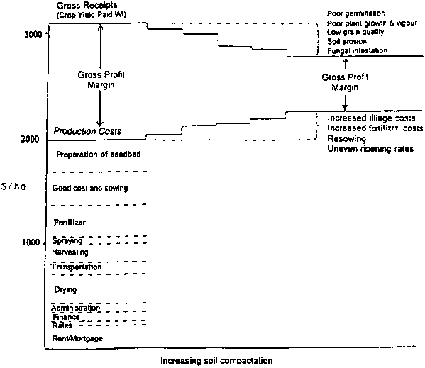
¤ higher energy needs for tillage (e.g., Figure 1).
FIGURE 1. Effects of soil compaction on gross margins under continuous cultivation (Shepherd, 1992)
Conversely, improvements in these micro-scale features can result in decreased occurrences of "deforestation", "overgrazing" and "excessive cultivation".
Observations
Observing what is happening at field level gives clues to why problems of land degradation are occurring, and what sustainable improvements need to be instituted and maintained before land quality can be seen to have improved.
The most useful information will be that which combines the perceptions, observations and studies of the land-users themselves (derived from full-time experience of their own surroundings) with the complementary observations, understandings, studies and analyses by technical support staff.
The results of such observations must feed-back upwards so as to inform successive levels of decision-makers - starting with the farmers themselves, through technical administrators, to national policy-makers - about the necessary detailed content of suitable decisions about land use and management appropriate to each level.
CHOOSING SIGNIFICANT INDICATORS
It is difficult to know how and where to start the selection of a limited number of indicators from among the enormous range.
From a conceptual standpoint it appears that, for an overall first level of assessment of change in land quality, from which the outlines of remedial measures might be derived, three broad types of key indicators may be the most important:
a. Above the soil surface, as related with yields:
¤ Cover close to the ground: its density, distribution, duration, timing.¤ Stress in plants: growth rates; timing and frequency of wilting; visible nutrient deficiencies or imbalances.
b. On the soil surface, as affecting particularly soil moisture and runoff + erosion:
¤ Porosity of at least topsoil layers, in millimetric bands: proportions of incident rainfall becoming infiltrated;
c. Below the soil surface:
¤ Organic matter content and biological activity, as affecting multiple features:Soil architecture:
· structural stability;
· gas exchange
· water movement and retention/release;Cation exchange capacity:
· nutrient capture and retention;
· pH buffering;
· nutrient availability;
· source of small amounts of recycled nutrients.
IMPORTANCE OF RURAL PEOPLE'S VIEWS
Monitored data, especially concerning both changes in conditions of natural resources and changes in people's activities, may have large margins of error ("background noise") related to uncontrollable variations in weather, politics, markets etc., and/or to long time-scales over which the changes occur. Qualitative information from a range of sources and indicators may then prove to be just as reliable and useful as quantified information in the assessment of the type, direction and rate of change of land quality in an area (Casley and Kumar, 1987).
Farm families use their own very pragmatic indicators of the condition of their crops and soils in making day-to-day decisions about how they will use and manage their lands. All policy changes which affect them are ultimately filtered through their decision-making processes, with results that may have positive or negative effects on land quality - or their decisions may block any change from occurring. If the land-users are ignored and marginalized in the process of deciding how to deal with problems of loss of land quality, the chances of them being interested in implementing suggested solutions is very slim, as past experience in several countries shows.
It makes sense to ask those who live on the land and have continuous knowledge of what is happening for information that can provide at least qualitative information, perhaps semi-quantitative data, and local history, from which the outlines of the more readily-perceived changes can be discerned. From these beginnings it can be decided what further detail and what complementary work may be needed to complete the information provided.
Farm families' comments may provide information on many different aspects of change which they perceive (using their own indicators, plus their views of the explanations of observed changes), for example:
¤ density of populations of people, and of animals, according to changes in land condition;¤ patterns of out- and in-migration, and reasons;
¤ levels of satisfaction/dissatisfaction with present conditions of life in the farm/village community;
¤ changes in values of agricultural land;
¤ re-investment in agriculture, and/or in non-farm activities;
¤ effects of drought periods on crop growth and stability of yields;
¤ productivity of crops, pastures, trees;
¤ incidence and severity of pests and diseases of crops and animals;
¤ diversification of on-farm enterprises;
¤ reasons for doing farm operations in particular ways;
¤ uses and values of favoured indigenous vegetation;
¤ springflow and streamflow characteristics;
¤ colours of plants and soils;
¤ output: input relationships;
¤ soil physical conditions and energy needed for tillage;
¤ additional costs in re-planting areas from which soil and inputs have eroded;
¤ spread of salinized areas;
¤ increases and decreases in runoff and soil erosion;
¤ disappearances, re-appearances of birds and other wildlife;
¤ frequency of burning residues etc.;
¤ reasons for cutting/not cutting nearby forest trees;
¤ "traditional" practices for maintaining productivity, catching water, soil, etc.;
¤ reasons for/against implementing currently-promoted recommendations;
¤ innovations taken up after hands-on training;
¤ farmer-to-farmer transfers and adaptations;
¤ farming systems, equipment types, etc.;
¤ activity of worms, etc.;
¤ and others.
For examples see also: Bhuktan et al. 1994; Wijewardene and Waidyanatha, 1984; Hinchcliffe et al., 1995; Tamang, 1993; Pretty, 1994; Cassel and Lal 1992.
If change in some form is not noted by farmers on the spot, it may not be very significant in the first instance, nor warrant much time spent on numerous and detailed analyses of a mass of factors. This is consistent with the pragmatic "subtractive-survey" approach that assumes that the situation is all right unless it can be shown to be otherwise (Shaxson, 1981). It is at this point that results from broad-area monitoring of key indicators (from remote sensing, market studies etc.) - which may show generalized views of land-quality decline - interlink with micro-scale results arising from farm-level monitoring.
At field-level it makes sense to start with characterizing the changes that farmers have begun to notice, then moving on to related linked changes of which farmers may not be aware, and only then, when available resources have been adequately deployed in this way, start more speculative monitoring of less-obvious changes that may or may not be important.
These comments and information may suggest to field staff particular pointers to further appropriate indicators.
Farm families will remark on things they perceive and see. Practical training to recognize small or hard-to-distinguish features can result in farmers becoming closely involved in monitoring. However, they may need assistance to foresee future problems or potentials which may be apparent to advisory staff but not yet within the perceptions of the farm families. These too may require monitoring, for which appropriate indicators would need to be identified by advisory staff: e.g., volatility of prices of particular crop; effects of too-deep tillage in bringing up more-unfavourable subsoil materials; too-great reliance on disc equipment for tillage, in view of potentials for severe sub-surface compaction developing; etc. (e.g., Vieira and Shaxson, 1995:9-11).
Farm-family members' statements on changes in output, food security, farming system etc. are comments about after-effects of combinations and integrations of changes in social, economic and/or technical details that may have taken place.
Within the area controlled by a community, the inhabitants' own comments are often important and illuminating concerning the nature and direction of change: such comments as:
"Things have/have not changed; they are different/better/worse (a) than before, or (b) than I would have expected under the present conditions [of e.g. weather pattern]".
In deciding which indicators may be the best to use, the spirit of co-participation is favoured (and suspicions of outsiders' motives minimized) when the local inhabitants themselves are requested to suggest the indicators which they would use to characterize changes in the land that surrounds them, and in their own livelihoods. Such indicators are pragmatic, involve people's own self-interest, are likely to be enthusiastically monitored by those involved, and represent those things in the farmers' world which are changing most quickly and/or by the greatest amount.
Personal observations by technical staff may provide further insights - for example, sizes of boulders moved by the stream, presence of plants indicating incipient salinization etc. - and be complemented by records of indicators from hydrographs, meteorological records, laboratory analyses of soil conditions etc., as appropriate.
Examples of farm-level pointers to indicators
Farmers' comments make useful first "signposts" as to what may be most significant.
An example of a pointer to choosing appropriate indicators is provided by one remark of a small farmer in Costa Rica when asked his opinion about the effects of an (ongoing) project: "El terreno se ve fofo" - "The soil is seen to be 'fluffy'".
This may be taken as an indication of changes in characteristics that can be quantified, such as: bulk density; porosity; pore-size distribution; mechanical resistance; root proliferation; etc (see, e.g., Cassel and Lal, 1992:71, 72). Similar comments are heard from farmers in other situations as well - including comments of disadvantageous soil changes, for example, as the result of long-continued application of mineral fertilizers (e.g., Tamang, 1993:7).
"In the village of Pacayas, we talked with Elias Zalaya, a farmer-extensionist about the improvements on his farm and in the village. The land had been abandoned as virtually worthless when he took it on some 10 years ago: 'We planted maize here, but it just wouldn't grow'. The unimproved soils are barely a few cm thick, and beneath them is hard bedrock. The soil on his farm is now remarkable [from using green manures and leguminous high-bulk cover crops such as Mucuna]: where he has contour grass strips, the soil has formed terraces 1.3 metres high. The terraces are almost flat, and the soil thick, springy to the step, and covered with a thick layer of decomposing organic matter." (Honduras: Pretty, 1994).
The description is an indicator of soil changes, but the nature of the changes (for purposes of comparison with other places, other times) would benefit by being characterized by quantification of, for example, organic matter composition, organic activity, texture, architectural (structural) condition, pH, nutrient composition and availability, etc.
Older inhabitants of an area may be able to provide qualitative - and perhaps semi-quantitative - information on changes in, for example, groundwater and streamflow conditions that have occurred over the last several decades.
An informant in the Changar project area in India told the author about the increase in land-eroding flood flows of a stream which formerly ran for much of the year tranquilly through his parents' land without causing damage to river banks. In more recent years floodflows have caused severe erosion of the stream banks and loss of significant areas of his cultivable land. Also in recent years the dry-season flow has been significantly less than it had been in his parents' time. He was able to indicate on the valley-sides the levels to which the worst flood each year generally rose, both presently and about 50 years ago. These are semi-quantitative indicators of changes in hydrologic condition of the catchment.
It was these comments, noted while standing on the river bank with this farmer, that initiated the understanding that one of the major problems of the region is in fact decline in porosity of the soil surface in forest and grazing areas, rather than human-induced erosion of soil as so commonly assumed. The understanding that lesser proportions of rainfall are entering the soil than in earlier years would help to explain increase in flood severity, falling availability of grass for fodder and of leaves and branches of trees and bushes for fodder and fuel.
This insight suggests that useful indicators of change, whether as continuation of downward trend, or as reversal to upward trend of improvement, would be the depth/time profiles of soil moisture changes and seasonal volume/time profiles of water availability in wells and streams.
"Farmers used indigenous indicators for determining the reduction in soil erosion [following their implementation of improved soil husbandry methods, again using high-bulk legumes and recycling of organic matter]. Some of such indicators included: soil becoming softer over years; plants growing uniformly; changing colour of soils from dull brown to darker colours; contour wall becoming smoother without slumpage during the rainy season; land strips in the contour farm becoming flatter; water flowing out of the field and water in nearby creeks are fairly clear in contrast to muddy conditions in the past; stone pebbles on the soils not visible any more; decreased frequency of landslides and contour wall slumpages; sticky soils becoming loam thereby absorbing much of rainwater thereby reducing the speed of rainwater flow on the surface; the increase in the depth of top soils on the farm; lesser and lesser deposits in the contour canals, soil traps and check dams and the like." (Albay Province of the Philippines: Bhuktan et al., 1994).
These indicators are clearly useful and valid, and their monitoring is a matter of observation. Quantitative measurements of each of these would be difficult, expensive and time-consuming, and the measurement of only a few of the above qualitative indicators would be justified. But the difficulties of quantification of even a few in no way diminish the importance of the qualitative observations of the many which are here apparent.
In the state of Paraná, Brazil, the cultivation of farmland within about 100 metres of a particular stream earlier had been abandoned because of the increased incidence of a small black biting fly known locally as "Borrachudo". Detective work by local field staff showed that excessive applications of pesticides had resulted in significant amounts washing into the stream and killing the fish which otherwise ate many of the aquatic larvae of the fly. Without this control, the fly multiplied to unacceptable numbers and the land was abandoned. Advice and training on more restrained use of pesticides by the farmers resulted in much less pesticide reaching the stream; the fish eventually returned, again exercised control on numbers of the fly, and the stream-side areas were again brought back into tillage (author's notes from a field trip, 1986).
Farmers' observations and responses led to detailed investigations and characterization and monitoring of indicators of detrimental changes in qualities of both land and water. Observation of indicators led to investigations that led to actions, and subsequently also followed the beneficial changes that followed application of the chosen remedies.
OTHER SOURCES OF INDICATORS
Non-farm people
Other sources of relevant pointers to indicators are staff in both the technical and administrative arms of the district administration: advisory staff can provide information on commonly-observed changes across the District as a whole which individual farmers may not have remarked; the District Roads Engineer may comment on the increased/diminished costs of road maintenance due to changes in severity of runoff and erosion; the popularity of local political figures may be affected by their support for (or indifference towards) rural improvement programmes which have resulted in improved land quality; variations in the local water authority's costs of treating water for urban/domestic use may indicate changes in the sediment and chemical loads in river-flow from the catchments upstream.
Photography
It is important also to add one's own observations and interpretations to what farmers say and show. In addition to note-taking, an ordinary hand-held camera is an important tool for recording observations which otherwise may be difficult to quantify or to describe adequately in words. Although it has great potential for recording serial changes at particular places, the simple camera is much under-used for this purpose. Photography merits more promotion as part of the monitoring record. In addition to single photos in two dimensions, two photos of the same scene, from viewpoints only a few centimetres apart, are in most cases sufficient to record three-dimensional views which can be recreated even with small and inexpensive viewers, including pocket stereoscopes.
Photographs can provide visual records of changes and differences over time, and from place to place, of physical features which otherwise would have no permanent record (see for instance Tiffen et al., 1994). Semi-quantitative comparisons may be possible from a carefully-planned series of photos of the same place at different times, and of a common feature in different places at almost the same time. Photo sequences of time past may suggest what complementary indicators should or could be measured in future.
Scoring
Where quantitative data may be difficult to define and collect, systems of scoring of particular features provide an intermediate and valid step. An example relating to land condition/quality is summarized in Appendix 2 (Douglas, 1995: 17-26).
FEEDBACK TO FARMERS
To become partners with farmers in improving land condition and quality, it is essential to provide them with feed-back, and to discuss with them the results of analyses which have been undertaken both on data which they themselves have collected, and of other monitored information. This is a powerful way of initiating discussion on making further improvements to land-use practices and to the indicators that would be monitored to follow change and progress.
FARMER-TO-FARMER SPREAD
Farmers experiment with and maybe adapt new ideas to their individual circumstances before they decide whether or not to adopt them. An indicator of their enthusiasm for and satisfaction with some new method, which may include better land husbandry practices, is therefore the rate of spread through informal farmer-to-farmer contacts independent of any efforts by extension staff (see, for example, Bunch and Lopez, 1994; Cheatle and Njoroge, 1993).
SUSTAINABILITY
In rural situations, farm-family members' attitudes, perceptions, observations, suggestions, knowledge, insights, interpretations and comments can be particularly important. It is their views of apparent benefits or costs arising from changes which will determine whether they will sustain the improvements in future. These comments may also indicate whether they are becoming more, or less, satisfied with their situation because of changes in the condition and quality of the land. Such comments may indicate a (human) aspect of sustainability affecting their expected permanence of residence. If they are increasingly dissatisfied as time goes on, many will leave an area and fail to maintain its productivity. If, as the land quality improves, they are increasingly satisfied, the land will be well husbanded and maintained. Their degree of satisfaction is also a useful indicator of change in land quality, though once again the reasons for change and the nature of necessary improvements require more detailed analysis than mere monitoring of the indicator.
CONCLUSION
Selected indices and indicators alone can do no more than show that a situation is changing: the more specific the indicator, the closer the understanding of what detailed features of land are changing. But if remedies or improvements are to be applied, monitoring of indicators must be accompanied by feedback plus adequately-informed decision-making which ultimately produces a better impact of rural people on land quality through the filter of their own self-interested decision making.
Decline in land qualities highlighted by macro-scale indicators - such as deforestation, runoff and soil erosion - aggregated across a region or country, often have their bases at micro/millimetric scale, such as soil architectural/structural conditions and an individual farmer's decision-making processes. Understanding at this detailed level may be essential before appropriate strategies can be devised and policies made about how to effectively address and reverse the decline. However, when improvement has begun, increasingly aggregated and abstract indicators may be all that are necessary to show that improvements remain on course.
Rural people directly modify the land and affect its qualities, stability, productivity and usefulness. Thus, their views, observations, perceptions, indicators, records, requirements and aspirations are essential components in characterizing the present condition of the land, the history of changes to date, and how they would like to see it in future. It is through their field-level decision making and its consequences that improvements may be initiated and maintained. Under growing pressures of population, and of rising demand for agricultural and other rural products, traditional ways of maintaining the land's quality and productivity are often no longer adequate. It behoves the technical, administrative and political communities to become partners in helping them to develop their own skills, and the potentials of living organisms - particularly as they affect the self-recuperating capacities of soils and perennial vegetation - to improve the land in ways that can be sustained.
The problems of land quality decline may be recorded in purely technical terms. But their solutions cannot be provided by technical bio-physical "fixes" alone, nor (alternatively) by socio-economic "fixes" alone. Interdisciplinary work in partnership with farmers to ameliorate and solve the problems must acknowledge the necessity for working in an "ecology of disciplines", none of which can afford to work alone (Poole, 1971). In such a context, "indicators" do no more than indicate. Solving the problems to which they point requires additional work by field staff and others, in partnership with farm families, to identify and successfully implement sustainable improvements.
REFERENCES AND FURTHER READING
Behnke, R.H. and Scoones I. 1991. Rethinking Range Ecology: Implications for Rangeland Management in Africa. London: Commonwealth Secretariat with Overseas Development Institute and International Institute for Environment and Development. 38 p.
Bunch, R. and Lopez V. G. 1994. Soil Recuperation in Central America: Measuring the Impact Four to Forty Years On. Paper presented at International Workshop "New Horizons: Economic, Social and Environmental Impacts of Participatory Watershed Development". London: International Institute for Environment and Development. (Proceedings in preparation).
Casley, D.J. and Kumar, K. 1987. Project Monitoring and Evaluation in Agriculture. Baltimore/Washington: Johns Hopkins Univ. Press for World Bank. ISBN 0-8018-3616-6. 159 p.
Cassel, D.K. and Lal R. 1992. Soil physical properties of the tropics: common beliefs and management restraints. In: Myths and Science of Soils of the Tropics. Soil Sci. Soc. Amer. Spec. Pubn. No. 29. pp. 61-89. [R114].
Cheatle, R.J. and Njoroge S.N.J. 1993. Smallholder adoption of some land husbandry practices in Kenya. In: Working with Farmers for Better Land Husbandry. Hudson, N.W. and Cheatle, R.J. (eds.). London: Intermediate Technology Pubns. + World Association of Soil of Water Conservation (WASWC). ISBN 1-85339-122-0. pp. 130-141.
Douglas, M.G., 1995. Guidelines for monitoring and evaluation of better land husbandry. ENABLE - Newsletter of Association for Better Land Husbandry (UK). No. 4, Nov. 1995.
Elliott, C.R. (ed.). 1991. Evaluation for sustainable land management in the developing world. Vol. 2. Technical papers, IBSRAM Proc. No. 12(2). Bangkok: Internatl. Bur. for Soil Res. & Mgt. 631 p.
FAO. 1977. Assessing soil degradation. Soils Bulletin 34. Rome: FAO. ISBN 92-5-100410-2. 83 p.
FAO. 1983. Guidelines: land evaluation for rainfed agriculture. Soils Bulletin 52. Rome: FAO ISBN 92-5-101455-8. 237 p.
FAO. 1991. A study of the reasons for success or failure of soil conservation projects. N.W. Hudson. Rome: FAO, Soils Bulletin 64. ISBN 92-5-103087-1. 65 p.
FAO. 1995. Agricultural investment to promote improved capture and use of rainfall in dryland farming. Rome: FAO. FAO Investment Centre Technical Paper No. 10. ISBN 92-5-103630-6. 46 p.
Haigh, M.J. 1994. Editorial: is sustainability enough?. ENABLE - Newsletter of Assoc. for Better Land Husbandry, UK. Issue 2. p. 3.
Hinchcliffe, F.; Guijt, I; Pretty, J.N. and Shah, P. 1995. New horizons: the economic, social and environmental impacts of participatory watershed development. Gatekeeper Series No. 50. IIED, Sustainable Agriculture Programme. London, UK.
Kiome, R.M. and Stocking, M.A. 1993. Soil and Water Conservation in Semi-Arid Kenya. Chatham (UK): Natural Resources Inst. ISBN 0-85954-359-5. 59 p.
Oldeman, L.R., Hakkeling, R.T.A. and Sombroek, W.G. 1991. Global Assessment of Soil Degradation - GLASOD: World Map of the Status of Human-Induced Soil Degradation. An Explanatory Note. ISRIC/UNEP. ISBN 90-6672-046-8 34 p. + maps.
Poole, D.A. 1971. Involvement or commitment? J. Soil & Water Cons. (USA). Mar/April. 1971. pp. 42-43.
Pretty, J.N. 1994. Pers. comm.: Trip report, Sept. 1994. [95/4/3]
Shaxson, T.F. 1994. Introducción al concepto moderno de manejo integrado y conservación de suelos. In: Memorias del Taller Sobre Planificación Participativa de Conservación de Suelos y Aguas, Paraguay y Brasil, 21-30 Junio 1992. Santiago de Chile: FAO/RLAC. Proyecto GCP/RLA/107/JPN. Doc. de Campo No. 5. pp. 27-79.
Shaxson, T.F. 1981. Determining erosion hazard and land use capability: a subtractive survey method. Soil Survey and Land Evaln. Vol. 2, 1981. ISSN 0206-9088.
Shaxson, T.F., Hudson, N.W., Sanders, D.W., Roose, E. and Moldenhauer, W.C. 1989. Land Husbandry: A Framework for Soil and Water Conservation. Ankeny (USA): Soil & Water Cons. Soc. ISBN 0-935734-20-1. 64 p.
Shepherd, T.G. 1992. Sustainable soil-crop management and its economic implications for grain-growers. In: Proceedings International Conference on Sustainable Land Management. P.R. Henriques (ed.). 17-23 Nov. 1991. Napier, Hawkes Bay, NZ. ISBN 0-473-01548-X. pp. 141-152.
Stocking, M.A. and Sanders, D.W., 1992. The impact of erosion on soil productivity. In: People Protecting their Land. Proceedings 7th ISCO Conference, Sydney, 27-30 Sept. 1992. Sydney: International Soil Conservation Organization (ISCO). Dept. Cons. & Land Mgt. ISBN 0-7305-9977-9 (2 vols). pp. 102-108.
Tamang, D. 1993. Living in a Fragile Ecosystem: Indigenous Soil Management in the Hills of Nepal. London: International Institute for Environment and Development. Gatekeeper Series No. SA41. 23 p.
Tiffen, M., Mortimore, M. and Gichuki, F. 1994. More People, Less Erosion: Environmental Recovery in Kenya. Chichester (UK): Wiley. ISBN 0-471-94143-3. 311 p.
United Nations. 1993. Agenda 21: The United Nations Programme of Action from Rio. Rio Declaration on Environment and Development. United Nations, New York.
Vieira, M.J. and Shaxson, T.F. 1995. Criterios para la identificación y selección de alternativas técnicas para el uso, manejo, recuperación y conservación de suelos y agua. San José (Costa Rica): Min. Agri. y Ganadería/FAO. Proyecto MAG/FAO/Holanda GCP/COS/012/NET. Documento de Campo No 32. 37 p.
Wijewardene, R. and Waidyanatha, W. 1984. Conservation Farming for Small Farmers in the Humid Tropics: Systems, Techniques & Tools. Colombo/London/Eschborn: Min. Ag. Devt. & Research/Commonwealth Secretariat/GTZ. 39 p.
APPENDIX 1
FROM PROJECT OBJECTIVES TO POSSIBLE INDICATORS - AN EXAMPLE
A. LINKAGES
Principal Objective
The adequate management and conservation of renewable natural resources, for the purpose of diminishing the rate of erosion, and at the same time working towards augmenting productivity in the agricultural, pastoral and forestry sector, thus obtaining indirectly improvement of the quality of life of the communities located in the four sub-catchments; this would provide protection to the investments made by [the Corporation] in the hydro-electric complex and extend the useful life of the dam...
|
Intermediate objective 1 |
Intermediate Objective 2 |
Intermediate Objective 3 ... | ||
|
Specific Objective 1.1 |
Specific Objective 2.1 |
etc. | ||
|
Activity 1.1.1 |
Specific Objective 2.2 |
| ||
|
|
Components |
|
| |
|
|
|
Benefit 1.1.1.1 |
|
|
|
|
|
-> Indicators |
|
|
|
|
|
Benefit 1.1.1.2 |
|
|
|
|
|
-> Indicators |
|
|
|
Activity 1.1.2 |
as ¬ |
| ||
|
|
Components |
|
| |
|
|
|
Benefit 1.1.2.1 |
|
|
|
|
|
-> Indicators |
|
|
|
Specific Objective 1.2 |
|
| ||
|
|
Activities |
|
| |
|
|
|
Benefits as above |
|
|
|
|
|
Components |
|
|
|
|
|
Indicators |
|
|
|
Activity 1.1.2 |
|
| ||
|
|
Benefit 1.1.2.1 |
|
| |
|
etc. ¯ |
|
| ||
Specific Objective 1.1
Crop, pasture and forest production, and conservation of soils in 31 mini-catchments of 3 sub-catchments by the end of 1996...
Activity 1.1.1
180 demonstration plots
Components:
.1 Physical works
.2 Vegetative strips
.3 Fruit trees
.4 Forest trees
.5 Inputs and seeds
.6 Fencing
Benefits expected, for example from
.1 Physical works
|
EXPECTED BENEFIT |
POSSIBLE INDICATOR |
|
Short term | |
|
a. Catch runoff water |
a. Water lost: none/some/all |
|
b. Catch eroded soil, organic matter |
b. Soil held: much/little/none |
|
c. Limit rilling and initiation of gullies |
c. Rills etc. below: yes/no/frequency |
|
d. Promotion of cultivation along contour |
d. On contour: yes/no |
|
e. Maintenance of yield levels |
e. Year: year records: farmers' assessments |
|
f. Increased soil moisture |
f. Sampling |
|
Medium term | |
|
g. Less sediment available for movement downstream |
g. In streamflow: more/less |
|
h. Soil nutrients less quickly exhausted |
h. Results of soil sampling |
|
i. Better results from application of inputs |
i. Yields; farmers' records, comments |
|
j. More cash income |
j. Farmers' records; visual evidence |
|
Long term | |
|
k. Less sediment entering reservoir |
k. Less rapid loss of capacity |
|
l. More secure food supplies per family |
l. Farm-families' comments; survey results |
|
Possible dis-benefits | |
|
m. Part of field taken out of production |
m. Measure widths, calculate % |
|
n. If banks break, damage worse than before |
n. Visual evidence |
|
o. Costs of construction and maintenance |
o. Farmers' records, memories |
|
p. Inconvenience to farm operations |
p. Farmers' comments |
|
q. Time and labour for construction |
q. Farmers' records, comments |
|
r. Yield benefits delayed |
r. Research whether soil or water effect. |
|
WHAT ARE FARMERS' OPINIONS? |
FARMERS' OWN COMMENTS MAY PROVIDE MOST APPROPRIATE INDICATORS. |
Similarly for other Objectives, Activities, Components, Benefits.
B. EXAMPLE
Intermediate objective 1
Creation of an extension service to promote participation of communities and individuals in managing and conserving renewable natural resources... among some 10 000 small farmers occupying some 22 000 ha. Also to install and manage 7 sets of runoff plots for obtaining data about rates of erosion.
APPENDIX 2
SCORING - AN EXAMPLE
|
Land Quality Indicators Shifting Viewpoints ¤ Indices and indicators not enough: macro-scale decisions must have taken account of micro-scale factors, e.g., a farmer's decision-making processes, soil architectural conditions, etc. ¤ Accelerated runoff and erosion are consequences, not prime causes, of prior land/soil problems: consider deforestation, overgrazing, excessive cultivation from different standpoint. ¤ Significance of soil as the environment (biological + physical + chemical + hydrologic) for rooting, and as buffer for rainwater. ¤ Critical roles of soil-biologic dynamics, and thus of life-based self-recuperating capacities of soils and perennial vegetation. ¤ Farm-families' observations, perceptions and comments are full-time, integrative, and are prime entry-points for choosing indicators. ¤ Importance of qualitative information, and of photos. ¤ Improvements in sustainability are chiefly possible only via integration of agro-ecologic and socio-economic considerations by the multitude of farm families. ¤ Key indicators: · cover close to the ground; |
Source: Qualitative guidelines for monitoring and evaluation of better land husbandry. (Douglas, 1 995)
![]()
![]()
![]()