![]()
![]()
![]()
The CEE regional component is the first attempt to involve institutions, governments and scientists in building up a comprehensive network of participants aiming to achieve the objectives of GTOS. The first phase of the programme, similar to a feasibility study, has focused attention on problems and needs for establishing such a complex observation system.
The participation of relevant institutions in an overall network system under GTOS is essential for a successful outcome of the programme. Clear identification of user needs on the one hand, and potential benefits for contributors on the other, is required.
The potential users of information include governmental bodies, research institutes and universities, NGOs and international organizations. Most frequently, their data and information requests have to be satisfied at specific time and spatial scales (for more detailed analysis see Annex 2).
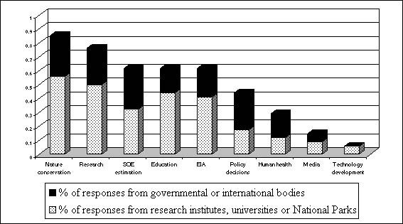
Environmental data is currently used for nature conservation and research purposes and to a lesser extent for decision-making, as shown in the analysis of the questionnaire responses (see Figure 2.1). The results clearly demonstrate that a wider use of data should be encouraged. This is where GTOS could play an important role.
The data requirements of potential users relate to biodiversity, land use, vegetation structure, land cover, soil quality and climate on a yearly time scale. The spatial scale of desired data ranges from local and national to regional. The need for data at a regional scale could be satisfied by GTOS CEE and it would therefore provide added value to existing systems. The first phase showed that data from a few intensively monitored sites (many variables, high resolution) is preferable to that from a large number of less intensive sites. Data must be comparable to be useful, therefore where possible it should be harmonized or at least put in a form that allows comparisons.
Despite observation activities in the region, there are gaps in data and information availability that raise difficulties in assessing regional effects of global change. The main types of information gaps are listed in the Table 2.2.
The information requirements relate mostly to identifying existing observation systems, on-going programmes, methodologies and contacts. Such information can be obtained by producing meta-databases, as planned by many of the Ministries of the Environment in the region. The process of building meta-databases should be facilitated by GTOS. Another type of information that would be beneficial to potential users is interpreted, analysed, synthesised results on environmental changes, effects and relations at different resolutions. This could help collaboration in environmental modelling. As providing this type of information is the main objective of the GTOS programme, the elaboration of such outputs is considered a priority issue.
Fig. 2.1. Analysis of Responses to Questionnaires
The delivery of data and information in an internationally standardized form raises language problems. Governments produce their meta-databases in their national language. Thus the elaboration of international internet based information systems led by national initiatives will generate political questions as well. Information must be timely and user friendly. The elaboration of expert or decision support systems is a high priority.
The CEE programme must make an early decision regarding the institution of a centralised database or the setting up of national and thematic data storage. Both solutions raise problems. In the case of national systems, governments have difficulty in hiring staff to create these systems due to high salary demands. The setting up of a centralized GTOS database, on the other hand, would require large human and financial investments.
General data and information access and release policies must be defined in the initial stages of the programme. As a result of political changes, both governmental bodies and independent institutes now control their own budgets and see data production as a source of income. Thus the willingness to share data is very low. A radical change must take place in order to permit this new programme to function. A Memorandum of Understanding with nations to release data might help. GTOS distinguishes between different kinds of data: i) basic data - which is available free and unrestricted; ii) conditional data - available free but with conditions of use attached; iii) bilateral exchange - freedom of use depends on agreement between parties.
Capacity building is also another priority issue in the region. Training in the construction of complex environmental databases, metadata systems, data protection, storage, in-data analysis and evaluations would be of great assistance to countries. Guidance tools in the form of handbooks and manuals would provide information on how to make observations and to manage data and information. Decision-makers must understand the importance of making environmental information available. Environmental monitoring expertise in the region seems to be adequate.
Table 2.2 Information Gaps
|
Information gaps |
Time scale |
Spatial scale |
|
Soil quality |
|
|
|
Impact of management on grasslands |
10-20 years |
Europe |
|
Development trends in specially protected parts of nature |
|
|
|
Extent of individual habitats and their dynamics |
|
national |
|
Aquatic biomass or production from reservoirs |
Monthly-yearly |
national-regional |
|
Biodiversity changes |
Yearly |
national, Europe |
|
Impact of pollution |
Yearly |
Europe |
|
Indicators of biodiversity changes |
Yearly |
national |
|
Soil conditions |
Yearly |
national |
|
Characteristics of water quality and water management |
Yearly |
national |
|
Meta-database |
|
|
|
Tree increment |
Yearly |
local |
|
Habitat coverage and changes |
Yearly |
national |
|
Species richness |
Yearly |
national |
|
Spatial distribution pollution data: air pollutants, toxicity, heavy metals, VOC, radiation |
Monthly |
national |
|
Changes of wetlands and oxbows |
Yearly |
national |
|
Changes in water quality in wetlands |
|
|
|
Satellite pictures |
|
1:100000 |
|
Global area maps of plant and animal species |
|
1:500000 |
|
Species monitoring |
Yearly |
national |
|
Climate |
Monthly |
local |
|
Air pollution |
Monthly |
regional |
|
Access to large compiled database |
Yearly |
national |
|
Free access to pollution, emission and other data |
|
national-district |
|
Detailed database (all from 6 except climate) |
Daily-weekly |
local to regional |
GTOS should facilitate operational activities, through fund raising (mostly from national sources) to maintain existing and develop new monitoring infrastructure and institutional support. Defined and effective lines of communication amongst data collectors, data managers and users must be solved both at the national level (between sectors and networks) and at the international level (between participants and GTOS contacts).
The user needs assessment should be on-going, with periodic surveys and consultations, taking into account new users, emerging issues, shifts in priorities and technological improvements. There is a need for a mechanism to keep these factors under continuous review and have sufficient flexibility to respond to changing needs.
Many countries of the region have not given high priority to setting up a complex system of monitoring sites. This is due to a number of reasons. National efforts are focused on problems relating to accession to the European Union. Others tend to concentrate on separate problems bound by national or bilateral conventions. However, it became clear, during the first phase of the CEE programme, that the countries in the region undoubtedly need a system like GTOS to handle environmental issues of national and transboundary nature. It is therefore important that GTOS initiate collaboration within the programme by linking local and national requirements.
The above considerations are to some extent applicable to the scientific community. Scientists have extensive national and international contacts and participate in different projects that solve specific environmental problems. However, financial restraints and lack of Cupertino tend to isolate the results of their findings. GTOS appears to be the obvious central point where information acquired in separate projects could be collected and disseminated on a regional, as well as national, basis.
It was clearly shown, during the first phase of the regional GTOS programme, that the major environmental issues defined as key questions at the global scale are valid for the regional scale as well. However, their importance and priorities have regional features. The future CEE GTOS system has to take into account regional threats and their relation to existing environmental information. GTOS should use existing information related to these issues on the one hand, and fill gaps in knowledge on the other.
The first phase of the CEE identified the following relations between major threats and existing information:
Pollution - data provides not only essential information on pollutants, but also on related human health problems and their inter-related influence on living systems and critical loads.
Land quality - requires greater monitoring at the landscape level in order to take account of the effects of socio-economic changes in the region which cause differences in land usage.
Biodiversity - monitoring should be expanded and existing observation networks must be integrated into a detailed global plan.
The strategy for coordination and information dissemination was formulated as a result of regional findings. A three-year Plan of Action was defined (see section 6) with suggestions for further initiatives at a later date. A series of projects, discussed during the workshop of the GTOS CEE programme (September 1999), have been identified and listed in Table 5. GTOS will continue to facilitate the development and identification of funding for the activities in collaboration with the national focal points.
![]()
![]()
![]()