![]()
![]()
![]()
Alexandre Borde
Environment and Natural Resources Service, FAO
1. Introduction
The Central and Eastern Europe (CEE) programme is the first regional initiative of the Global Terrestrial Observing System (GTOS). Initiated in early 1999, it aims to reinforce information exchange on terrestrial ecosystems between researchers and decision-makers at the global and regional level. This programme aims at assessing the specific requirements of users in the CEE.
GTOS attempts to improve exchange of data on environmental issues. It facilitates access to available data and assists countries in focussing on local and regional environmental problems. To achieve this, both local observations and global aggregated data are required. It is essential to ensure that such data are efficiently collected by local institutions to serve as input to national policy makers and scientists.
This survey involved sending questionnaires to selected recipients in Central and Eastern Europe to ascertain their involvement in terrestrial information. The information obtained was used to set out a programme for user requirements in the CEE.
2. Objectives and Methodology
Among the principal objectives of the CEE programme are:
i) The prioritisation of the five GTOS global environmental issues in the Central and Eastern European context;
ii) The identification of gaps in the field of terrestrial information collection, harmonization, management and exchange;
iii) The review of terrestrial ecosystem monitoring sites.
An analysis of this information assists in the formulation of the regional implementation plan and helps to develop awareness of emerging environmental issues. It is important that GTOS take into account the specific variables, data and information tools that each of the users requires and that its activities be targeted towards products of interest to users.
A questionnaire (see Section 6) was designed to provide both qualitative and quantitative data. For example, to prioritise the five GTOS environmental issues, recipients were asked to rank these from 1 (most important) to 5 (least important). More general questions aimed at gaining an insight into existing activities regarding collaboration in terrestrial observations or missing data types were included. Information on contacts was also requested. The questionnaire was sent to approximately 250 recipients from Central and Eastern European countries. These were selected on the basis of their involvement in environmentally related activities, both in the scientific community and from governmental bodies. The questionnaire was distributed in the English language.
3. Potential Users of GTOS
The main users of GTOS in Central and Eastern Europe fall into three categories: research scientists (mainly environmental scientists), technicians and managers (mainly from international agencies and organizations associated with the operation and management of technical development and application programmes) and policy makers and planners (mainly from national governments).
The scientific community frequently has the greatest capacity to collect environmental information and is the group most interested in accessing and participating in regional and global networks. It requires global coverage of certain key variables at a resolution consistent with the scale at which the processes operate, and sufficient to make global and continental-scale inferences. It also needs some very detailed and high-resolution data sets for limited areas and periods in order to develop new hypotheses and rigorously test the broader-scale approaches. While scientists and researchers in Central and Eastern Europe have the capability to undertake advanced environmental research programmes, they usually lack access to long-term monitoring data that are consistent across space and time.
Technicians and managers in international organizations have responsibilities regarding the monitoring and assessment of terrestrial ecosystems, particularly if they are parties to Conventions such as the Framework Convention on Climate Change (FCCC), the Convention on Biological Diversity (CBD) or the Danube Basin Convention.
Governmental bodies of the region face new environmental issues. These may be related to new regulations of Conventions to which their country subscribes or when new environmental threats arise at the local or national level. Countries often lack data on terrestrial ecosystems and on trend analysis to cope with these emerging issues. Furthermore, some of the CEE countries have to apply to new European standards and, at the same time, negotiate and implement environmental Conventions and protocols.
GTOS aims not only to develop the use of terrestrial observations, but also to facilitate information exchange. It is expected that the three types of users identified above can also provide inputs to GTOS. Researchers may provide considerable input into GTOS, particularly in the early stages of any activity, by providing advice on the variables to be observed, the techniques to be used, and on appropriate methods of data analysis and data management. Technicians and managers can also advise GTOS on their new and continuing data and information needs. Policy makers often require the generation of secondary and tertiary data such as social, economic and environmental indicators for national planning. They also need to work closely with scientists to ensure that data relevant to their requirements are collected or generated
4. Analysis of Questionnaire Responses
A total number of 34 responses were received by GTOS. The rate of responses was approximately 14%.This low figure may be the result both of the difficult situation in the Balkan countries at the time of the survey and of the fact that the questionnaire was available only in English. The table below shows the number of responses by country.
Table 3.1. Distribution of respondents by profile
|
Country |
Responses from research institutes, universities or National Parks |
Responses from governmental or international bodies |
Total number of responses |
|
Armenia |
|
1 |
1 |
|
Bulgaria |
1 |
|
1 |
|
Czech republic |
5 |
2 |
7 |
|
Estonia |
2 |
2 |
4 |
|
Georgia |
|
1 |
1 |
|
Hungary |
6 |
2 |
8 |
|
Latvia |
|
1 |
1 |
|
Lithuania |
|
1 |
1 |
|
Poland |
1 |
1 |
2 |
|
Romania |
4 |
|
4 |
|
Slovakia |
2 |
|
2 |
|
Slovenia |
|
1 |
1 |
|
Ukraine |
|
1 |
1 |
|
Total |
21 (62%) |
13 (38%) |
34 |
In order to assess the main GTOS environmental issues (changes in land quality, impacts of climate change, availability of freshwater, loss of biodiversity, pollution and toxicity), the respondents were asked to rank the issues in order of importance to them.
Table 3.2. Ranking of the five GTOS environmental issues
|
GTOS environmental issues |
Ranking average |
|
Changes in land quality |
2.56 |
|
Impacts of climate changes |
4.34 |
|
Availability of freshwater |
2.78 |
|
Loss of biodiversity |
2.35 |
|
Pollution and toxicity |
2.73 |
Loss of biodiversity is considered the major issue by respondents from Central and Eastern Europe, with an average rank of 2.35, although this figure may reflect some bias due to the fact that a significant number of respondents work in ecological research institutes or national parks. Changes in land quality is also an important issue. With the end of the communist era, the privatization of land has brought about fragmentation and new practices in land management. This has generally affected the quality of land due to soil depletion. Availability of freshwater and pollution and toxicity are very closely ranked. Although these issues are important with respect to human health, due to the decrease in the industrial production in the region, levels of pollution and toxicity no longer appear to pose a major threat. Although availability of freshwater is not a major issue in this temperate region, the quality of the water can be more problematic. Climate change, with an average of 4.34, ranks significantly lower than the other issues. This could be explained by the fact that the CEE region is not confronted with threats such as desertification, rises in sea level or the shrinking of glaciers. On the other hand, it could also be that there is a lack of awareness of the subject within the region.
The survey also served to identigy potential sites not yet included in the Terrestrial Ecosystem Monitoring Sites (TEMS) meta-database.
Table 3.3. Potential TEMS sites
|
Country |
Name of the sites |
Address of responsible institutions |
|
Armenia |
· Lake Sevan (freshwater reservoir) |
· Several institutions among which the Ministry of Nature Protection |
|
Bulgaria |
· Moussala, NP Rila |
· BAS, Institute for Nuclear Research and Nuclear Energy, Sofia |
|
Bulgaria |
· Alinitza, NP Rila |
· BAS, Institute for Nuclear Research and Nuclear Energy, Sofia |
|
Czech republic |
· Bílé Karpaty |
· Sprava CHKO Bílé Karpaty, Veselí nad Moravou |
|
Czech republic |
· White Carpathians Moravia |
· White Carpathian Protected Landscape Reserve Administration, Luhacovice |
|
Czech republic |
· Krkonoše Mts. Bohemia |
· Krkonoše NP Admin., Vrchlabí |
|
Czech republic |
· Reservoir Vltava River watershed |
· Hydrobiological Institute, AS CR, Ceské Budejovice |
|
Estonia |
· Saarejárve EE02 |
· Tartu University, Institute of Geography, Tartu |
|
Hungary |
· Szigetköz |
· Fertô-Hanság NP and the Office of Nature Conservation |
|
Hungary |
· Kis-Balaton |
· Balatonfelvidek NP |
|
Hungary |
· Duna-Ipoly |
· Duna-Ipoly NP Admin. |
|
Hungary |
· Lake Velence and Dinnyés |
· Duna-Ipoly NP Admin. |
|
Hungary |
· Bükk |
· Bükk NP, Eger |
|
Hungary |
· Szarvas |
· Körös-Maros NP, Szarvas Anna-Liget |
|
Hungary |
· Duna-Dràva |
· Duna-Dràva NP, Pécs |
|
Poland |
· Kampinoski Park Harodowy |
· Kampinos NP |
|
Romania |
· Baia Mare |
· Vasile Coldis Western University, Arad |
|
Romania |
· Zlatna, Western Carpathian Mountains |
· Institute of Biological Research, Clui Napoca |
|
Slovakia |
· Small Fatra (Terchova) |
· Institute of Landscape Ecology, Bratislava |
|
Slovakia |
· Moravsko-Sliezske Beskydy (Turzovka) |
· Institute of Landscape Ecology, Bratislava |
|
Slovakia |
· Danube inundation (Gabcikovo) |
· Institute of Landscape Ecology, Bratislava |
|
Slovakia |
· Little Carpathian (cadaester Castá) |
· Institute of Landscape Ecology, Bratislava |
|
Ukraine |
· Danube Delta biosphere reserve |
· Danube Delta Biosphere Reserve Admin., Odessa Oblast |
|
Ukraine |
· Lower Danube Lakes |
· Odessa State University, Centre for Environmental Monitoring, Odessa |
In addition, respondents could be asked to provide further information on current networking or terrestrial observation collaboration activities such as those summarized in Table 3.4.
Table 3.4. Networking activities
|
Country |
Type of efforts |
Name of the project |
Main institutions |
|
Bulgaria |
Collate terrestrial observations |
NA |
· Institute for Nuclear Research and Nuclear Energy, Sofia · Institute of Zoology, Sofia · Institute of Botany, Sofia |
|
Czech Republic |
Network of sites |
LTER |
· Hydrobiological Institute, Ceské Budejovice |
|
Czech Republic |
Network of sites |
Biosphere reserves integrated monitoring |
· MAB National Committee, Prague |
|
Czech Republic |
Coordination of terrestrial observations |
Biomonitoring of the State Nature Conservancy in CR |
· Agency for Nature Conservation and Landscape Protection, Brno |
|
Estonia |
Network of sites |
The Conservation Area Net |
· Estonian Agricultural University, Tartu |
|
Estonia |
Network of sites |
The Estonian National Biodiversity Monitoring Master Plan |
· Estonian Environmental Information Centre, Ministry of Environment, Tallinn |
|
Georgia |
Collate terrestrial observations |
The Environmental Standards Database |
· EBRD and PHARE |
|
Georgia |
Collate terrestrial observations |
Observation of forests and protected areas |
· Dept. of Biodiversity and Protected Areas, Ministry of Environment, Tbilisi |
|
Georgia |
Collate terrestrial observations |
Environmental Pollution Monitoring |
· National Centre of Environmental Monitoring, Tbilisi |
|
Georgia |
Collate terrestrial observations |
Country Biodiversity Studies |
· NACRES |
|
Hungary |
Collate terrestrial observations |
Monitoring of forest health |
· Forest Research Institute |
|
Hungary |
Network of sites |
Network of agricultural and forestry pest and diseases sample spots and light traps |
· Plant Protection RI, Forest Research Institute |
|
Hungary |
Collate terrestrial observations |
Biodiversity Monitoring System |
· Dept. of Nature Conservation, Ministry of Environment, Budapest |
|
Hungary |
Collate terrestrial observations |
Soil Conservation Information and Monitoring System |
· Ministry of Agriculture and Regional Development |
|
Hungary |
Collate terrestrial observations |
Environmental Monitoring System |
· Ministry of Environment |
|
Latvia |
Collate terrestrial observations |
State Environmental Monitoring Programme |
· Environmental Consulting and Monitoring Centre, Riga |
|
Lithuania |
Collate terrestrial observations |
National Environmental Monitoring Program |
· Joint Research Centre, Ministry of Environment, Vilnius |
|
Poland |
Collate terrestrial observations |
Land cover inventory CORINE |
· Institute of Geodesy and Cartography, Warsaw |
|
Poland |
Collate terrestrial observations |
Biotopes inventory CORINE |
· Institute of Nature Protection, Krakow |
|
Poland |
Collate terrestrial observations |
Nature Monitoring |
· Inspectorate for Environmental Protection, Warsaw |
|
Romania |
Collate terrestrial observations |
Nature Protection in Romania |
· Romanian Academy, Committee for Nature and Natural Monuments Protection, Bucharest |
|
Romania |
Collate terrestrial observations |
Research and Education |
· Faculty of Biology, University of Bucharest |
|
Slovakia |
Collate terrestrial observations |
Health State and Biodiversity |
· Institute of Landscape Ecology, Bratislava |
|
Slovakia |
Collate terrestrial observations |
Changes in relationship to ozone, SO2, NOx pollution |
· Forestry Research Institute, Zvolen |
The reasons for use of existing data were assessed and described in Table 3.5.
Table 3.5. Main purpose of data currently used
|
Purpose |
Responses from research institutes, universities or National Parks |
Responses from governmental or international bodies |
Total number of responses |
|
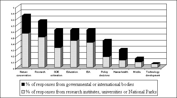
Nature conservation |
19 |
10 |
29 |
|
Research |
17 |
9 |
26 |
|
SOE estimation |
11 |
10 |
21 |
|
Education |
15 |
6 |
21 |
|
EIA |
14 |
7 |
21 |
|
Policy decisions |
6 |
9 |
15 |
|
Human health |
4 |
6 |
10 |
|
Media |
3 |
2 |
5 |
|
Technology development |
2 |
0 |
2 |
Nature conservation and research are the two major topics for which existing data are used. If responses from the scientific community only are taken into account, education is considered an important activity for which data are used (71% of the responses of researchers), while the decision-makers tend to use data for the State of the Environment and environmental impact assessments. The graph below shows the percentage of the responses by type of users.
Fig. 3.1. Percentage of responses by type of users
In order to obtain a better understanding of the use of data by respondents, details on data resolution and variables used on a regular basis, were requested The table below illustrates responses indicating the data type in rows and the data resolution in columns.
Table 3.6. Resolution of data types used regularly
|
Data type |
Resolution |
|||||||
|
Time |
Space |
|||||||
|
day |
week |
month |
year |
local |
national |
regional |
||
|
Land use |
|
1 |
1 |
14 |
4 |
12 |
6 |
|
|
Land cover |
|
2 |
2 |
13 |
6 |
12 |
10 |
|
|
Biomass |
|
1 |
2 |
9 |
7 |
2 |
7 |
|
|
Primary production |
1 |
3 |
4 |
8 |
8 |
5 |
5 |
|
|
Litter |
|
3 |
4 |
7 |
8 |
2 |
5 |
|
|
Decomposition rate |
|
|
2 |
4 |
6 |
|
1 |
|
|
Vegetation structure |
1 |
2 |
4 |
14 |
13 |
6 |
10 |
|
|
Leaf area index |
|
4 |
6 |
5 |
6 |
4 |
4 |
|
|
Land degradation |
|
3 |
4 |
9 |
7 |
6 |
9 |
|
|
Hydrology |
1 |
1 |
4 |
6 |
6 |
3 |
5 |
|
|
Biodiversity |
1 |
1 |
3 |
19 |
9 |
15 |
11 |
|
|
Air quality |
3 |
3 |
6 |
7 |
8 |
11 |
4 |
|
|
Freshwater quality |
|
1 |
9 |
8 |
9 |
8 |
4 |
|
|
Soil quality |
|
|
3 |
11 |
7 |
8 |
5 |
|
|
Climate |
4 |
3 |
6 |
11 |
6 |
10 |
7 |
|
|
Total |
11 |
28 |
60 |
145 |
110 |
104 |
93 |
|
In terms of time resolution, the main scale of the data used is yearly, apart from leaf area index. Climate data are measured on a daily, monthly and yearly resolution.
The geographic scale varies from local to regional. Soil quality and vegetation structure are mostly local, while land use, land cover and biodiversity data are measured at the national scale.
After surveying the data used by respondents, users were asked to specify the type of missing data to which they would require access. Table 3.7 presents the qualitative types of missing information.
Table 3.7 List of type of missing data mentioned
|
Type of missing information |
Time scale |
Spatial scale |
|
Soil quality |
|
|
|
Impact of management on grasslands |
10-20 years |
Europe |
|
Development trends in specially protected parts of nature |
|
|
|
Extent of individual habitats and their dynamics |
|
national |
|
Aquatic biomass or production from reservoirs |
month-year |
national-regional |
|
Biodiversity changes |
year |
national, Europe |
|
Impact of pollution |
year |
Europe |
|
Indicators of biodiversity changes |
year |
national |
|
Soil conditions |
year |
national |
|
Characteristics of water quality and water management |
year |
national |
|
Meta-database |
|
|
|
Tree increment |
year |
local |
|
Habitat coverage and changes |
year |
national |
|
Species richness |
year |
national |
|
Spatial distribution pollution data: air pollutants, toxicity, heavy metals, VOC, radiation |
month |
national |
|
Changes of wetlands and oxbows |
year |
national |
|
Changes in water quality in wetlands |
|
|
|
Satellite images |
|
1:100000 |
|
Global area maps of plant and animal species |
|
1:500000 |
|
Species monitoring |
year |
national |
|
Climate |
month |
local |
|
Air pollution |
month |
regional |
|
Access to large compiled database |
year |
national |
|
Free access to pollution, emission and other data |
|
national-district |
|
Detailed database (all from 6 except climate) |
day-week |
local to regional |
4. Analysis of Questionnaire Responses
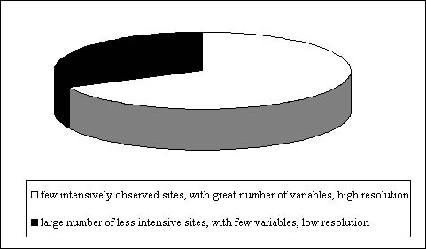
With respect to monitoring activities, respondents were asked to indicate how missing information could be provided. Two data collection activities were proposed: a limited number of intensive sites with a greater number of variables and a high resolution, and a large number of generic sites with few variables and low resolution. Several respondents ticked both boxes (these responses have been taken into consideration since the question was not exclusive).
68% of respondents preferred few intensively observed sites with a greater number of variables and high resolution to a large number of less intensive sites with few variables and low resolution. This is consistent with the type of missing information identified i.e. complex variables such as soil conditions, species richness, etc.
Finally, respondents were requested to identify potential users of a programme like GTOS. Respondents were classified in different categories.
Table 3.8 Main potential users of GTOS
|
Main potential users of GTOS |
Responses from research institutes, universities or National Parks |
Responses from governmental or international bodies |
Total number of responses |
|
Scientific community |
16 |
8 |
26 |
|
Regional decision-makers |
13 |
7 |
20 |
|
Governmental bodies |
9 |
9 |
18 |
|
NGOs |
11 |
5 |
16 |
|
General public |
5 |
4 |
9 |
|
Media |
5 |
2 |
7 |
|
Private sector |
2 |
2 |
4 |
Governmental bodies, regional decision-makers, the scientific community and NGOs are seen as main users. It is interesting to note that NGOs are also seen as an important users of GTOS.
4. Main Results
GTOS aims to supply data and information to various categories of users. Some results of this survey are listed below and could serve as an input into the implementation plan of GTOS for Central and Eastern Europe.
Priority should be given to biodiversity monitoring and analysis;
The importance of climate change in the region needs to be investigated further;
Institutions responsible of the terrestrial monitoring sites inventoried in the survey should be approached for completion of the TEMS form and their agreement should be asked to figure in the TEMS metadata base;
GTOS should contact existing networks and programmes for terrestrial observation, and propose regional thematic partnerships;
Some efforts should be made in terms of missing variables, either by proposing more research - for complex variables for which data are not collected on a routine base - or by assisting in the aggregation or the harmonization of the data when available but not compiled into datasets;
In addition to the scientific community, governmental bodies and regional policy makers, GTOS should establish contacts with NGOs.
The assessment of user needs should be a continuing process of GTOS, since experience indicates that requirements change with time as a result of new users and new issues.
6. Questionnaire to Help Initiate GTOS for Central and Eastern Europe
By responding to the questions below, you may contribute to the development of the Central and Eastern Europe component of GTOS concerning user requirements on terrestrial observation information.
Contact information
|
Family name: |
First name(s): |
|
Institution: |
Mailing address: |
|
Country: |
Tel: |
|
Title of position: |
Email: |
1. The following issues are addressed by GTOS. Please prioritise the most important threats to your county or region (from 1 most important, to 5 least important). Identify others if you consider them more important than the ones listed.
|
changes in land quality |
|
|
freshwater resources |
|
|
loss of biodiversity |
|
|
climate change impacts |
|
impacts of pollution and toxicity
|
other |
|
Refer to relevant data that supports this selection, or give the reasons for your answers. (Use additional pages if needed.).
| |
2. A GTOS meta-database called the Terrestrial Ecosystem Monitoring Sites (TEMS) - is already available on the internet[1]. It allows access to information on terrestrial observation and monitoring stations. A selection of them for CEE countries is given in Annex 3. Evaluate the observations done at the sites (if any) in your country on the basis of GTOS issues. Match the relevant issue and the observations carried out at the site(s) in your country list.
|
changes in land quality |
|
|
freshwater resources |
|
|
loss of biodiversity |
|
|
climate change impacts |
|
|
impacts of pollution and toxicity |
|
|
other: |
|
3. List sites you may know that are not included in the TEMS database but that are relevant to GTOS.
|
Name of site, location |
Address of responsible Institution |
| |
|
4. Do you know of any efforts in your country to collate or coordinate terrestrial observations or to build a network of sites?
|
Yes |
|
No |
|
If yes, please give the details below.
|
Type of effort |
Responsible institution, address, name of coordinator |
| |
|
5. To your knowledge, for what purpose is the data currently used that is originating from the environmental observations? Select by a tick (Ö) or specify.
|
research |
|
policy decisions |
|
nature conservation |
|
|
education |
|
human health |
|
media |
|
|
environmental impact assessment |
|
state of environment estimation |
|
||
|
technology development |
|
other |
|
||
6. Please select (Ö) the type of data you regularly use in your work and specify the resolution of variables.
|
Data type |
Resolution |
|||||||
|
Time |
Space |
|||||||
|
day |
week |
month |
year |
local |
national |
regional |
||
|
land use |
|
|
|
|
|
|
|
|
|
land cover |
|
|
|
|
|
|
|
|
|
biomass |
|
|
|
|
|
|
|
|
|
primary production |
|
|
|
|
|
|
|
|
|
litter |
|
|
|
|
|
|
|
|
|
decomposition rate |
|
|
|
|
|
|
|
|
|
vegetation structure |
|
|
|
|
|
|
|
|
|
leaf area index |
|
|
|
|
|
|
|
|
|
land degradation |
|
|
|
|
|
|
|
|
|
hydrology |
|
|
|
|
|
|
|
|
|
biodiversity* |
|
|
|
|
|
|
|
|
|
air quality* |
|
|
|
|
|
|
|
|
|
freshwater quality* |
|
|
|
|
|
|
|
|
|
soil quality* |
|
|
|
|
|
|
|
|
|
climate* |
|
|
|
|
|
|
|
|
|
other* |
|
|
|
|
|
|
|
|
7. Please specify your information needs that are not
satisfied because of the lack of data collected or the lack of access to
collected data. If the data are collected but are not available to you please
tick this box. 
|
type of missing information |
time scale |
spatial scale |
| |
|
|
8. What type of data sources do you think could best provide you with the missing information?
|
few intensively observed sites with great number of variables, high resolution |
|
large number of less intensive sites with few variables, low resolution |
|
9. Identify the main potential users of a future GTOS information supply in your country.
|
governmental bodies |
|
non-governmental organizations |
|
|
regional decision-makers |
|
media |
|
|
scientific community |
|
general public |
|
|
|
|
private sector |
|
|
other |
|
|
[1]
http://www.fao.org/gtos/pages/tems.htm |
![]()
![]()
![]()

