![]()
![]()
1. Background
The world today is undergoing a period of rapid change. Human numbers have increased dramatically in the past two centuries and there are now few land areas of Earth where people do not live. Their presence and activities have had a profound effect on the environment of the planet and its natural ecosystems. Land has been cleared for cultivation and livestock. Huge cities and industrial developments cover large areas. In recent decades rapidly increasing waste emissions from industry have been liberated into the air and waters, and deposited onto land surfaces sometimes thousands of kilometers from their source. These waste emissions are having increasingly severe impacts on the environment and many are proving to be health hazards, or are toxic, to people and other organisms. The distributions of natural ecosystems and their constituent species are consequently changing, biological diversity seems to be decreasing, and the climate is being altered bringing yet more changes so that major agriculture zones are likely to shift position. These changes are now collectively termed global change.
For the last 50 years or so scientists have become increasingly aware of global change and its likely effects, and their consequences for human well-being. They have begun to investigate the environmental and ecological processes involved and to develop mathematical simulation models for some of them at scales ranging from the local to the planetary. As scientific knowledge has increased and the effects of global change have become more obvious to many, there has been a call from scientists for more and better data to enable better scientific understanding of the processes involved, and the development of improved models for making more accurate and reliable forecasts of impending global changes and their consequences.
At the same time national economic planners and resource managers, especially in developing countries, have begun to realize that national renewable natural resources, including managed agricultural ecosystems, have to be used wisely and in sustainable ways if they are going to continue to support increasing populations. It has become obvious in recent years that sustainable use of renewable natural resources can only be achieved if there is sound understanding of where these resources are located, their extent, how they function, and how they are affected by changing local natural and societal circumstances. Consequently, national planners and resource managers have been seeking reliable data and information on which to base national development policies and strategies, to manage relevant national programmes, and to achieve the wise use and management of national renewable natural resources including those of crop and forest lands. Much of this information can only be obtained from scientists through their research physical, biological and social programmes.
In the last five decades there have been attempts to monitor the global environment and its components, the best known of which was the Global Environment Monitoring System (GEMS) which involved 23 interactive thematic networks. This was, however, largely financed with international funds and so lacked the resources to develop to where it could operate in all geographic regions and cover all the topics deemed necessary. Only governments have the technical and financial means, and the political will, to undertake planetary scientific observations of the type, scope and magnitude required to gain scientific understanding of what is involved in global change. Similarly, only governments have the resources to obtain the data and information necessary to attain national sustainable development and the ability to achieve it, in spite of global change effects, through implementation of the right policies, strategies and actions.
Recognition of the need for good data of the right types by both national planners and scientists, and the growing realization by governments that they need sound scientifically based environmental and resource information for national development, have brought these two user groups closer together resulting in the evolution of a new world-wide system for studying global change and trying to fathom its causes and effects and to develop appropriate policy responses. This has become the Global Observing System (GOS).
GOS is not a functional entity but operates as three separate but closely related observing systems. The first, the Global Climate Observing System (GCOS), deals with climate and climate related aspects of the global environment. The GCOS Secretariat is located in the World Meteorological Organization (WMO) at Geneva. The second, the Global Ocean Observing System (GOOS), deals with ocean and coastal aspects of the global environment. The GOOS Secretariat is located at Paris in the Intergovernmental Oceanographic Commission (IOC) of the United Nations Educational, Scientific and Cultural Organization (UNESCO).
The third and youngest, the Global Terrestrial Observing System (GTOS), deals with terrestrial aspects of the global environment, including both natural and managed ecosystems. The GTOS Secretariat is located currently in the Food and Agriculture Organization of the United Nations (FAO) at Rome. This Implementation Plan is concerned with making GTOS operational, and with its future development. The Plan rests firmly on the foundation laid by the GTOS Planning Group in its 1996 report (see Annex I).
2. GTOS Programme
The Global Terrestrial Observing System was established in 1996 in response to a growing need for understanding the effects of global change in terrestrial ecosystems on sustainable development. The five sponsors - Food and Agriculture Organization of the United Nations (FAO), International Council for Science (ICSU), United Nations Educational, Scientific and Cultural Organization (UNESCO), United Nations Environment Programme (UNEP) and World Meteorological Organization (WMO) - collaborate to promote stronger links between scientists and policy makers.
GTOS is a dedicated long-term, integrated, user-driven observing system for monitoring the extent, form and function of terrestrial ecosystems, including those of managed lands, and detecting and measuring alterations in them resulting from climate changes, changes in human activities such as land-use and industrial development, and changes from other causes. GTOS addresses the total terrestrial ecosystem complex, including coastal systems, and thus considers biological, chemical and physical properties as well as terrestrial, oceanic, hydrological and atmospheric processes. GTOS is, therefore, global in scope with comprehensive world-wide coverage and deals with phenomena that are global in their nature or impact. In these respects GTOS complements the other two Global Observing Systems (GCOS and GOOS), by working through joint panels to develop common procedures for data management and space observations, and collaborating on land-climate and land-coastal zone issues. GTOS will continue to develop close inter-system working links in the future, especially when seeking funds for joint activities.
The central mission of GTOS is to provide policy makers, resource managers and researchers with access to the data needed to detect, quantify, locate, understand and warn of changes (especially reductions) in the capacity of terrestrial ecosystems to support sustainable development.
This programme aims to provide guidance in data analysis and to promote (a) integration of biophysical and socio-economic geo-referenced data; (b) interaction between monitoring networks, research programmes and policy makers; (c) data exchange and application; and (d) quality assurance and harmonization of measurements methods.
GTOS focuses on five issues of global concern:
changes in land quality;
availability of freshwater resources;
loss of biodiversity;
climate change.
impacts of pollution and toxicity;
The issues are along thematic lines because GTOS must be directed at specific users and their needs. In general the issues are concerned with anthropogenic impacts on terrestrial ecosystems. In the beginning GTOS will concentrate on Land-use and Land-cover change, Water resources, and Climate change. GTOS is thus helping to obtain better understanding of some of the basic issues confronting sustainable human development: food and food availability; freshwater supply and demand; changes in terrestrial ecosystems and their life support capacities; changing biological diversity; and exposure of people and other life forms to toxic and hazardous substances.
The GTOS Co-sponsoring organizations collectively form the primary authority governing GTOS from which all other governing authority descends. The GTOS Steering Committee provides general guidance directly, and indirectly through its subsidiary Panels and Working Groups. A small GTOS Secretariat provides the continuity to keep GTOS operational on a-day-to-day basis.
To meet its objectives, GTOS will foster equitable partnerships between data providers and users that meet the short-term development needs of national governments and the longer term needs of the global change research community. High priority is given to the concerns of developing countries, which are among GTOS' most important potential data users.
GTOS is envisaged as a "partnership of partnerships", formed by linking existing monitoring sites and networks as well as present and planned satellite remote sensing systems. Outputs from Earth-observing satellites and environmental databases will be integrated with in situ observations.
By drawing together existing but disparate databases, sites and networks into a common framework, and harmonizing measurements and terminology, GTOS will increase substantially the usage and value of terrestrial ecosystems data and information for scientific assessment, development planning purposes and policy formulation.
By providing globally comprehensive and timely information on anthropogenic impacts on terrestrial ecosystems, it will help scientific research programmes and the secretariats of conventions and treaties such as on biodiversity, climate and desertification to fulfill their mandates.
Finally, GTOS activities will increase returns to major investments in independent in situ observation networks by providing complementary regional or global data, and in earth observation by satellites by providing comprehensive ground truthing through its system of networks.
The emphasis throughout GTOS is in the production of high quality, reliable and credible information and data obtained in a harmonized cost-effective manner, and collected to answer specific questions posed by users. They are accordingly at spatial and temporal scales appropriate to user needs. Spatial and temporal scaling aspects of GTOS data will have to be addressed early in GTOS development particularly in regard to upscaling and the extrapolation of data from observing sites to other, often larger, areas.
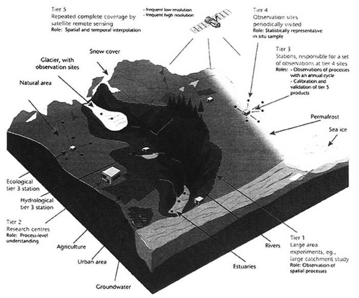
Key to the production of GTOS data is the five-tier Global Hierarchical Observing Strategy (GHOST) which is an incompletely nested sampling system that allows at one extreme for many variables to be collected at a few sites, and at the other extreme, a few variables to be collected at many sites. GHOST was designed specifically for observing climate-related variables. GTOS will have to test its applicability in other GTOS sectors. In making these data gathering observations only the most suitable proven methods for data acquisition, management and analysis are used. All data are backed by metadata that allows users to comprehend why and how the data were gathered and by whom. The Terrestrial Ecosystem Monitoring Sites (TEMS) strategy and database will play a key role in ensuring GTOS data are accompanied by adequate metadata.
A series of required climate-related terrestrial variables on which observations should be made has already been identified and defined by the GCOS/GTOS Terrestrial Observation Panel for Climate (TOPC). A similar series is needed for non-climate topics though it is recognized that this will be a very complex task which may need topic specific expert groups. The resultant data from GTOS can thus be used with confidence by both national policy makers, planners and socio-economists, and by the international science community. Where required, data are transformed into other forms more suitable for use in regional and national economic development. As far as possible, all data generated through GTOS will be readily available to potential users in a free and unrestricted manner at a cost no greater than that of reproduction and delivery.
1. Programme development
This Plan proposes a number of actions to be implemented according to three levels of priority: category A (very important - to be acted upon as quickly as possible); category B (routine activities); category C (important - but implementation can be delayed if necessary).
Early in its career GTOS must develop policies for key actions areas to include data and information release, publications, public relations, products, and, importantly, early warnings. These policies are intended as guidelines and not rigid rules of conduct and will help shape the future of GTOS while allowing it to retain the flexibility of approach that it must maintain to be successful.
2. Data Management and Information
GTOS should develop a data management and information system that focus on the following activities: development of databases to hold regional and sectoral data, both primary and derived, and associated data products; development of a long-term data referral system to identify the locations and access requirements of different types of data held both within and without GTOS; a database of metadata (see TEMS); and acquisition of appropriate tools for handling and sorting data. As models and similar instruments will be important to GTOS, consideration should also be given to assembling information on applicable models, interpretative tools, and decision-support systems.
Working Group and Panel on Data and Information
Information and data release are the centre of GTOS. They are vital to science, essential for national economic development, and can be potentially politically sensitive. Consequently, a Data and Information Working Group should keep the data approaches and problems under constant review. This informal group of Steering Committee members should be supported by an advisory Panel on Data and Information Release, that would consider how data and information from GTOS could be used by countries for national policy making and economic development.
Data Centres
An important element of GTOS development is the establishment of GTOS Data Centres where data will be held, processed and analyzed. Wherever possible these centres will be existing national or international centres (probably associated with GTOS partner networks and programmes) that have agreed to take on the additional GTOS role.
Data and Information Management Plan
The Data and Information Management Panel (DIMP) has drawn up a very good GCOS Data and Information Management Plan that has been thought through with such care that it will be able to accommodate GCOS future changing needs for some time to come. The development of such a plan specifically for GTOS and its terrestrial interests is therefore an essential activity that is under development. It should be finalized by the end of 1998.
3. User Needs
At its beginning, GTOS will have to spend considerable time and effort in carrying out extensive surveys of potential users of GTOS data and their needs. These users will be from many areas but fall into two broad categories: those associated with regional and national planning and development (policy makers, planners, technicians, managers), and those in the scientific research community, including international scientific programmes. Care will have to be taken when considering potential users from the private sector in view of the unrestricted nature of data release postulated for GTOS.
Initial contacts by GTOS representatives with potential private sector users should perhaps begin among the large multinational companies whose activities impinge on or affect the environment since some already have environmental policies in place which might make discussions easier. User needs, once identified, will form the basis for the development of future GTOS Programmes and their component activities. These needs will be reformulated into questions for which answers will be sought, which in turn will determine the actual variables to be observed and the methods to be used.
4. GTOS System of Networks
In starting GTOS properly it will be beneficial to demonstrate that the "network of networks" concept underlying GTOS is workable and realistic. A successful demonstration will be an aid in obtaining future support funds for GTOS activities. The best demonstration will be one in which terrestrial networks are brought together to form a GTOS system of networks (GT-Net), the main aim of which will be to better understand global and regional change.
The key activities will be to define a clear policy on data and information access; to share and exchange environmental data; to develop a set of standards for metadata as well as local/regional/global in situ data sets; and to undertake demonstration projects, the initial one being to estimate primary terrestrial productivity. Initially, GT-Net will focus on those networks that regularly make in situ terrestrial and freshwater measurements. Over the longer term, it will strive to meet the needs of the other Global Observing Systems on terrestrial issues relating to climate and oceans.
5. Finance
Crucial to the future of GTOS is its financial support. At the moment (1998) the Co-sponsors provide annual funds that are insufficient to enable GTOS to get off the ground properly. Although it is not intended that GTOS should ever command large financial resources, it will need seed money with which to start. Accordingly, the Co-sponsors must ensure that there are adequate funds and staff available to keep a small GTOS Secretariat running for the next three years, i.e. to 2000. Without a fully functional GTOS Secretariat many important development activities necessary to start GTOS and keep it going will not be carried out.
It is important, therefore, that a funding strategy is worked out for getting support for the Secretariat, and for the future funding of all GTOS projects and programmes on an activity by activity basis. As an aid to this a GTOS Database of Donors should be built up within the GTOS Secretariat, and a GTOS benefits package produced that shows the advantages to organizations, countries and donors of participating in, or supporting, GTOS. These will allow GTOS to develop a sound understanding of donor and grant giving bodies (bilateral, multilateral, foundation, industrial, etc.) in order that projects and activities can be matched to appropriate donors, and couched in forms that are more suitable for support by those donors.
6. Periodic Review and Audit
GTOS can only progress satisfactorily if its achievements are critically reviewed at regular intervals to ensure that it continues to adapt to the changing development and scientific needs of the time, and takes advantage of advances in relevant technology. It is also essential to carry out regular financial and administrative audits of GTOS to ensure that it continues to operate in the most cost-effective manner. Periodic Programme Reviews of GTOS should take place every three years, with the first at the end of 1999. Each review should be preceded by two technical assessments of the use being made of GTOS data and information by countries, and by international programmes. These assessments will be important inputs to each GTOS periodic revue. The financial and administrative audits of GTOS should be carried out at regular intervals in accordance with the practice and procedures of the organization that is host to the GTOS Secretariat (currently FAO).
7. Collaboration with GCOS and GOOS
Joint Coastal Observation System
High priority should be given to holding preliminary discussions with the Secretariats of GCOS and GOOS on the development of a future joint GCOS/GOOS/GTOS Coastal Observation System, starting with a strategy and an implementation action plan. The specific coastal area information needs of each of the global observing systems must be ascertained.
An early priority action for GTOS is also to agree, in association with GOOS, on a working definition of coastal areas. An important point in the definition is to fix the distance inland of the landward boundary of coastal areas.
Joint Socio-economic Panel
In addition to the existing joint panels with the other two global observing systems[1], GTOS should develop with GCOS and GOOS a Joint Panel on Socio-economic Aspects that would identify the socio-economic variables and causes that are needed for the interpretation of global change, and determine ways in which natural resources data could be used in socio-economic accounting effects. The need for societal benefits from the observing systems to be identified and defined is widely recognized but all three observing systems are composed largely of physical and biological scientists and so lack expertise in this area.
1. Background
How GTOS will develop in the early decades of next century will largely depend on how it progresses between 1998 and 2000. However, global changes will continue and new environmental issues will be identified, which will have to be faced by GTOS. Improvements in telecommunications and computer capabilities may lead to major changes in GTOS users and user demands. Ordinary people world-wide accessing GTOS from their homes or workplaces are likely to become one of the leading users of GTOS resulting in the use of data in new and innovative ways. Scientists will have better models with greatly improved predictive capabilities requiring data obtained with improved precision and accuracy of measurement which will have to be reflected in GTOS procedures.
Observations on new variables will be asked for as scientific understanding of environmental processes increases resulting in increased observational demands on GTOS which it must be prepared to meet. Socio-economic data gathering techniques will improve at all levels allowing more meaningful application of global change data to national development. Better links between science and development, in which GTOS must play a role, will result in more sensitive indicators, and improved indices and other relationships for determining social and ecological responses to global change. These could have profound implications for the future development of GTOS and the applications of its findings.
2. Networks
GTOS networks will continue to grow and improve both in coverage and scope as the value of GTOS becomes more apparent. This will be further enhanced as scientists begin to realize that the planet must be regarded as a functional unit in which compartments and processes are all interconnected. What happens in one place affects what is happening in other places. GTOS is an ideal vehicle for obtaining better data and understanding of these interlinkages. A core set of variables should be identified that will allow the state of the global environment to be tracked.
GTOS will play a key role in this and should establish a Global Warning Network that will draw attention to any significant perturbations in the state of any of the core variables and call for an investigation. GTOS Special Purpose Networks should be brought into operation to make measurements on variables not normally observed but which have been identified as of interest because they have been found to be involved in perturbations observed by the Global Warning Network or other global monitoring systems.
3. Sustainable development
Helping nations towards sustainable development will probably become the most important activity for GTOS in the future because it will affect in one way or another the lives and well-being of most of the world's population. Data from GTOS will enable better understanding of the processes of the environment and renewable resource utilization thus enabling greatly improved, more rational, national development planning. This must, in turn, lead to improved living conditions for people especially in developing countries. GTOS will have to concentrate on providing countries with sound practical advice on establishing national observing systems directly related to national development. To do this effectively GTOS should establish a GTOS Sustainable Development Unit within the structure of the GTOS Secretariat. As part of its sustainable development effort GTOS should also negotiate with individual countries for access to environment-related national statistical data. If these national data have been collected in accordance with acceptable international quality assurance and control procedures they will be valuable additions to GTOS databases that will not only aid sustainable development activities but will also contribute toward improving the science base of GTOS.
FIGURE 1: Diagrammatic representation of the Global Hierarchical Strategy (GHOST)
|
[1] TOPC (GCOS/GTOS Terrestrial
Observation Panel for Climate); J-DIMP (GCOS/GOOS/GTOS Joint Data and
Information Management Panel); GOSSP (GCOS/GOOS/GTOS Global Observing System
Space Panel). |
![]()
![]()