![]()
![]()
![]()
1. The biospheric layer
All life on Earth occurs within the narrow confines of a thin layer on the surface of the planet. This layer extends above the planetary surface for a few hundred kilometres, to the bottom of the oceans for a few tens of kilometres, and into the land surface for a few kilometres. Relative to the diameter of the planet this is a very thin layer, almost a smear. It comprises three interlinked compartments, the largely gaseous atmosphere, the surface crustal land masses, and liquid water forming the mainly saline oceans, shallow freshwater lakes and rivers, and water deposits in the upper crustal layers. This biospheric layer is greatly affected by the enormous and continuous, but fluctuating, stream of radiative energy that falls upon the Earth from the sun. It is also affected by the consequences of the lesser amounts of internal planetary energy released from radioactive decay and from the gravitationally induced squeezing of the interior of the planet.
2. Beginnings of life
These energy fluctuations, heightened in their variability by the annual orbiting of the Earth around the sun and the progression of the entire solar system through the complex radiative environment of deep space, cause the surface of the Earth to be in a constant state of interactive flux, a state that continues to this day. It is this highly variable surface environment that led to conditions for self-replicating life to start and to evolve continuously by constantly adapting to global and local changes in resource and energy availability. The story of life is thus one of how organisms evolve, develop and adapt (or do not adapt) to environmental change.
3. Human technology
In geologically very recent times one species evolved to the point where it developed technology which gave it the capacity to use and exploit the resources of the planetary surface for its own purposes in ways that no other species had been able to do before. This has allowed this species, humanity, to spread over the Earth's surface and to exert its influence on all but the most remote and inhospitable parts. The consequences of this exploitation are today rapidly affecting the nature of the surface layers of the planet in ways that profoundly affect all forms of life living in them. The extent and rapidity of these global changes are unusual in the history of the Earth; what is unique to the present is that these changes are being caused by one species.
4. Global change
Of the many challenges facing humanity today, two of the largest relate to global change. The first is to understand the nature and causes of global changes, their extent and the speed at which they are occurring. The second is to determine the consequences of global changes upon people (and on other living organisms), their health, and their well-being.
Global change and the use of models
Global changes can only be understood properly by knowing how the basic environmental processes involved actually work, and what happens when they are altered. This requires developing and testing theoretical mathematical models of relevant processes, and making careful accurate and precise measurements of selected relevant environmental variables so that data of known reliability are available for analysis, and for testing and verifying the models. To be of value to people the models must relate to the real world and this can only be done by using real world data in real world situations. Well developed and tested models allow scenarios as well as predictive statements to be made about likely future conditions; the better the model, the better and more practically useful are its predictions.
Scientists and planners
The second challenge is more difficult to meet because it involves the transformation of scientific data and knowledge into usable forms that are relevant to national development and personal well-being, and ensuring that these data are provided both quickly and routinely to those who will use them. Sustainable development very much rests on planners and managers having the right sorts of reliable natural resource and environmental data when they need them. Planners cannot afford to wait for the outcome of lengthy scientific investigations. They need useful data that they can rely on and they need them at varying time scales. This need can only be met if planners and scientists work closely together right from the start so that each group knows the needs, capabilities and limitations of the other.
1. Global Observing Systems versus monitoring systems
Global Observing Systems (GOS) are an important means of achieving the necessary scientific understanding of environmental processes and of global change in that they provide long-term reliable global data series that are essential for predictive model calibration, validation and further development. Current operational monitoring systems have usually been designed to help answer specific scientific questions and are thus limited in scope and purpose.
The wider more comprehensive GOS are generally more complimentary to broader scientific research approaches, such as that of the IGBP Global Change Programme, which will use many of the data collected or generated through the GOS. Relevant GOS data, especially terrestrial data, can also be made available more readily to planners and managers to use directly in economic planning and development, or in translated forms, or as a basis for the generation of more useful secondary and tertiary data such as social, economic and environmental indicators. Also the very term "observing" has a more open and less proprietary tenor to it than the more possessive and watchdog sounding 'monitoring'. This alone makes observing systems more acceptable to many of the more politically sensitive potential partners in a GOS.
2. Assessments and uses of GOS data
Data from traditional Global Monitoring systems are usually analyzed within the system in accordance with the purpose for which they were gathered so that it is the system that produces the intended assessments. In the Global Observing System approach all data are collected with the same rigor and care but without the GOS necessarily being responsible for more than a few of the subsequent analyses and assessments.
Thus GOS data, routinely gathered and made openly available to the international community, e.g. through the Internet, can be utilized by a wide variety of users - both institutional and individual - for a multitude of purposes ranging from model verification and improvement to the preparation of more traditional status and trend assessments. This has advantages: data are more readily available to a wider variety of users, and these same data may be used for purposes very different from the original objectives for which they were gathered.
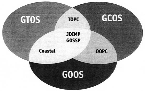
3. The three Global Observing Systems
Three closely linked global observation systems are in operation: the Global Climate Observing System (GCOS), the Global Ocean Observing System (GOOS), and the Global Terrestrial Observing System (GTOS). The first two are functional and the third is at the end of its initial preparatory stage and is about to start its establishment phase. The intention is that together the three GOSs will provide the nations of the world with integrated, multi-scale monitoring of global change and its causes and effects.
Global Climate Observing System (GCOS)
Sponsored by UNEP, WMO, IOC of UNESCO, and ICSU, GCOS is a dedicated observing system to meet the scientific requirements for monitoring the climate, detecting climate change, and for predicting climate variations and change on a variety of time scales. GCOS does not make observations or generate data products, but encourages, coordinates, or otherwise facilitates observations which must be made by national and international organizations in support of their own requirements as well as common goals. GCOS is thus supported by national governments and implemented through national agencies and organizations, with the assistance of national and international data management and distribution bodies.
It is intended that in the future GCOS will be able to specify needed observations, recommend appropriate techniques for measurements and data management, establish mechanisms for transmission, storage and distribution of GCOS data and data products, participate in capacity building and training activities, and advise in the application of GCOS data and information to national economic and sustainable development. For practical purposes the GCOS programme can be divided into seven broad interlinked categories (termed "missions" by GCOS):
Global radiative properties;
Ocean characteristics;
Ocean-atmosphere boundary;
Atmospheric dynamics;
Atmospheric composition;
Land-atmosphere boundary;
Land-biosphere climate response.
Of these seven categories it is the last three, the land-atmosphere boundary, land-biosphere climate response and atmospheric composition that are most relevant to GTOS and offer the most potential for co-operation between GTOS and GCOS. Data gathered through GTOS, however, is also of some relevance to three other GCOS categories (global radiative properties, atmospheric dynamics).
Co-operation between GCOS an GTOS has been excellent and on-going from the very start of GTOS. It is fair to say that if it were not for the interest in GTOS shown by the GCOS Secretariat and the practical support it has given to the early stages of GTOS, there would be no GTOS today. This applies particularly to the development of the GCOS/GTOS Plan for Terrestrial Climate-related Observations which was financed and supported by GCOS. The two Secretariats must ensure that future contact is maintained at the present excellent level.
Global Ocean Observing System (GOOS)
Sponsored by UNEP, IOC of UNESCO, WMO, and ICSU, GOOS is a mechanism for gathering, analyzing and assessing all types of marine and oceanographic data that are of common worldwide importance and utility as defined by a very broad spectrum of user groups. GOOS is a mainly a facilitative mechanism but also plays a key coordinating role in some activities. Emphasis is given to ensuring quality control of GOOS data and derived data products. Special attention is given to the distribution of data and information and in ensuring that GOOS outputs are in forms appropriate to specific users. GOOS is supported by national governments and implemented through national agencies, organizations and industries, with the assistance of national and international data management and distribution bodies. On the basis of user needs the GOOS programme has been divided into five inter-related modules that share observations, data networks and facilities. The GOOS modules are, in order of user interest:
Climate monitoring, assessment and prediction;
Monitoring and assessment of living marine resources;
Monitoring and prediction of the coastal marine environment (Coastal GOOS);
Assessment and prediction of the health of the oceans;
Operational marine meteorological and oceanographic services.
Of these five categories it is the first three, climate monitoring and assessment, living marine resources monitoring, and the coastal marine environment, that are most relevant to GTOS and offer the most potential for cooperation between GTOS and GOOS. Coastal GOOS comprises three elements -biologically related; marine navigation; and coastal hazards. GTOS interests lie principally with the first which can be further divide into land-use, habitats, and water quality, to which can be added biological diversity including living marine resources. It is also possible that GTOS could have a role in the coastal hazards element but this would be of lower priority.
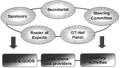
Global Terrestrial Observing System (GTOS)
Sponsored by FAO, ICSU, UNEP, UNESCO and WMO, GTOS is a network of networks for obtaining the terrestrial data needed to detect, locate, and quantify changes (especially reductions) in the form and function of terrestrial ecosystems. This Implementation Plan is concerned with the concept, organization, structure, programmes, development and future of GTOS.
4. Joint Panels
Joint Data and Information Management Panel (JDIMP)
The Joint Scientific and Technical Committee of GCOS established a Data and Information Management Panel (DIMP) to formulate, implement and oversee the GCOS data and information management system. In particular DIMP was to solicit data series from the climate community for GCOS based on data needs identified by the GCOS science panels, identify gaps in data available to GCOS, and coordinate efforts to redress these data deficiencies, bearing in mind the need for data quality to be of acceptable standard. Right from the start it was recognized that the data and information system for GCOS should be developed as a common framework that would accommodate data and data products from the climate modules of GOOS and GTOS as well as the World Weather Watch (WWW).
DIMP has, therefore, always included representatives of these programmes as members. DIMP also includes people with a broad range of expertise in a number of climate related backgrounds and disciplines. DIMP is a highly focused problem solving group that concentrates on resolving crucial issues affecting the quality of data and access to them.
With the more active involvement of GOOS and GTOS in this panel it was renamed in 1997 the Joint Data and Information Management Panel (JDIMP) to signify that it now serves all three Global Observing Systems. Subsequently, (Tokyo, July 1997) the role of JDIMP was reviewed and modifications suggested to better accommodate the requirements of the three Global Observing Systems, with the Terms of Reference being revised to reflect these changes. However, the practicalities of the transition from DIMP to J-DIMP will take some time before the change is properly reflected in the work (and composition) of the panel. Suggestions have also been made for improving the mechanisms for interaction between J-DIMP and the science panels.
Global Observing Systems Space Panel (GOSSP)
The steering bodies of the three Global Observing Systems (GCOS, GOOS, GTOS) recognized the need for a comprehensive approach to space-based observational activities and decided to establish an advisory panel that was common to the three observing systems. The panel was to inform the observing systems on ways in which space-based data could enhance their global programmes, and would also promote the space-based observational requirements of user communities carrying out global studies. It would do this by recommending to the space agencies how these requirements might be met. In other words, GOSSP is intended to be the focus for exploiting space systems in meeting the objectives of the global observing systems. GOSSP has served the three Global Observing Systems very well, particularly GCOS.
However, each observing system is now taking a more active and direct role in space-based data affairs. Increasingly, the three observing systems, and their Co-sponsors, are themselves present at key satellite meetings such as those of the Committee on Earth Observation Satellites (CEOS). This means that GOSSP no longer has to report on their activities, proposals and needs. Similarly, there is now no reason for GOSSP to report on satellite technology developments to the observing systems since such developments are quite adequately covered in reports produced by bodies such as CEOS. Therefore, the future role of GOSSP was redefined to assist in the interface between the G3OS and CEOS and to provide advice on space technology developments and facilities of relevance to the Global Observing Systems (to include, for example, aspects of high speed high volume data transfer, access systems, satellite telecommunication to remote areas, automatic data acquisition stations, animal tracking by satellites, and security measures).
Terrestrial Observation Panel for Climate (TOPC)
The TOPC is a joint panel established by GCOS and GTOS to ensure that there is a coordinated plan for obtaining the terrestrial observation requirements for GCOS and for the climate change requirements for GTOS. The plan provides a rationale for the structure of the initial operating system and outlines basic guidelines for its implementation. It describes the minimum set of land-based variables that are required to understand the climate system and its variability and to predict, detect and assess the impacts of climate change. The data and information management needs identified in the plan have been passed to the Joint Data and Information Management Panel (J-DIMP). Details of those observations that can best be made from space have been provided to the Global Observing System Space Panel (GOSSP).
The panel has produced two versions of the plan for terrestrial climate-related observations: Version 1.0, November 1995; Version 2.0, June 1997. Implementation of this plan will be done jointly by GCOS and GTOS in cooperation with the World Climate Research Programme (WCRP), the International Geosphere-Biosphere Programme (IGBP), the International Human Dimensions Programme (IHDP), and other international and national institutions and programmes.
TOPC is the most successful of the standing panels and has produced a scientifically sound and practical observation plan for the climate interests of GCOS and GTOS. TOPC will keep the plan under review and will refine and update it as circumstances require. As GTOS begins to develop its various special networks, it is certain that it will have to reconsider its data requirements and better define the variables that it measures.
FIGURE 3: Joint Panels of the three Global Observing Systems
|
GTOS: |
Global Terrestrial Observing System |
|
GCOS: |
Global Climate Observing System |
|
GOOS: |
Global Ocean Observing System |
|
TOPC: |
Terrestrial Observation Panel for Climate (GCOS/GTOS) |
|
JDIMP: |
Joint Data and Information Management Panel (GCOS/GOOS/GTOS) |
|
GOSSP: |
Global Observing Systems Space Panel (GCOS/GOOS/GTOS) |
|
OOPC: |
Ocean Observing Panel for Climate (GCOS/GOOS) |
|
Coastal: |
collaboration on coastal zone issues (GOOS/GTOS) |
![]()
![]()
![]()