4.2 General aspects of relevant data management
4.2.1 Sources of error
The assessment of erosion and sediment transport rates is a task subject to major difficulties and severe errors. It is worth emphasizing that such errors can be typically of one or two orders of magnitude. There are four main sources of errors in estimating sediment transport in streams:
a) Quality of samples. During the transport process, sediment particles experience their own dynamics that are not exactly the same as those of the water mass: particles continuously fall due to gravity, and are uplifted by the turbulence of the flow. This means that sediment concentrations can be very different within the flow section, and that any instrument placed within the flow will modify its local dynamics. Furthermore, some dilution or concentration of the sediment can be produced through the sampling process or during the handling or fractionating of the sample (Hadley & Walling, 1984).
b) Representativity of samples. The sediment concentrations at the same place are usually subject to strong variations in time. These variations are usually linked to the variations of water discharge but the relationship is usually nonlinear and subject to hysteresis phenomena. The temporal change in sediment concentration and the non linearity of its relationship with water discharge increases with the decreasing area of the basin (Walling, 1988).
c) Interpolation and extrapolation of samples. Because the sediment concentration is obtained for instantaneous samples, it is necessary to use some interpolation or extrapolation procedure to estimate a continuous sediment concentration that multiplied by the water discharge will give the sediment discharge (Walling, 1988, Walling & Webb, 1981).
d) Temporal integration of solid discharges: The temporal irregularity of sediment concentration and the non linearity of the relationship between sediment concentration and water discharge can be a major cause of error during temporal integration of solid discharges.
The Measuring Programme has been designed to minimize the errors introduced due to the first two mentioned sources of errors by an appropriate sampling design, taking into account the experience gained during the PAP/RAC pilot project. The third source of error could be avoided by making the minimum use of interpolation and extrapolation exercises, through obtaining a sufficient number of representative samples with the help of the automatic sampling. The fourth source of error is to be overcome by using the shorter time-step of integration possible, typically 5 minutes for small ephemeral catchments.
Nevertheless, it is important to bear in mind that neither do data series without errors or gaps exist, nor are perfect interpolation-extrapolation procedures available.
4.2.2 Interpolation and extrapolation
It is very difficult to prescribe easy-to-use rules for data interpolation and extrapolation because the objective of the Programme is not to obtain "official" data that would appear authoritative, but to provide reliable tools for analyzing water and land conservation strategies.
An outstanding example of one of these problems has been provided by the PAP/RAC pilot project, through the work of the Turkish team (PAP/RAC-UNEP, 1997). This example shows that the same information obtained through a sampling strategy can give very different sediment transport rates depending on the method used for interpolation and extrapolation.
Figure II-10. Relationship between instantaneous sediment and water discharge obtained through sampling at the Çenger station, Turkey
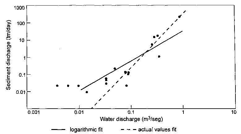
Source of data: Dogan & Sevinç, 1995
Figure II-10 shows, on a log-log graph, the instantaneous sediment transport rates obtained through field operator sampling in the Çenger station during the PAP/RAC pilot project, together with the "sediment rating relationship" customarily obtained by the log-log linear regression, and another regression line obtained by minimizing the residuals of the actual values instead of the logarithmic values. It is evident that the first regression gives a much better fit than the second one on this graph.
The two regression lines were obtained by minimizing the residuals of the logarithms and the residuals of the actual discharge values respectively.
Nevertheless, Figure II-11 shows the same data and regressions on a linear graph, demonstrating that, if the customary logarithmic fit is used, we can miss the information provided by the highest value of sediment transport observed.
Figure II-11. Relationship between instantaneous sediment and water discharge obtained through sampling on a linear scale at the Çenger station, Turkey
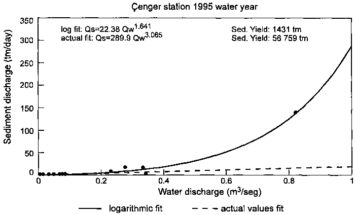
The same data and regressions of the former figure, but on a linear scale. The logarithmic regression gives an extreme underestimation of the major events, which play the major role in sediment transport. Note that the sediment transport estimated with the logarithmic regression is about forty times less than the transport estimated with the actual values regression, for the same data set.
In this case, using the same field data and calculation steps but different curve-fitting techniques, we obtain either 1,431 or 56,759 metric tons of sediment yield for 1995: a 1/40 ratio! This shows also that there is little value in using a large number of significant figures or decimals in the results: it gives a false impression of precision.
It is worth emphasizing that if the logarithmic regression is fitted to a subsample composed by the 10 points with a water discharge higher than 0.05 m3/s, the resulting regression takes the form Qs = 236.7 Ql3074, and the resulting sediment yield for the year is 46,776 tm, a value comparable to the estimate obtained with the equation fitted to the actual values. The problem is that this third procedure is subject to some degree of subjectivity, but it can avoid significant errors.
The recommendation is to use a curve-fitting technique which minimizes the residuals of the actual (non logarithmic) values. If this is not possible, it is necessary to check the adjustment of the fitted curve on a linear graph, and to select subsample sets or to weight the samples with their values (every sample being represented by n observations, where n is its sediment transport value) in order to obtain a good adjustment to the actual data.
4.2.3 Event analysis and temporal integration
The small size of the catchments as well as the ephemeral regime of the streams makes it necessary to perform detailed analyses of the events. An excellent example is provided by the Tunisian team during the Pilot Project (Boughrara, 1994), through the data represented in Fig. II-12.
The first comment suggested by this graph is the importance of the sampling frequency during such an event: one sample per day would be of very little value.
This kind of event needs a detailed analysis in order to obtain the appropriate information not only on erosion and sediment transport rates, but also on the processes active in the catchment.
Qualitative analysis: Fig. II-12 shows that water discharge somewhat precedes sediment concentration. This behaviour, for a small catchment, suggests that the sediment is mainly produced from the hillslopes: there is not a 'bulldozer' effect of the rising flood on the stream channel. It can also suggest that the main sediment sources are located in the headwaters. Finally, the sustained high sediment concentration during the recession suggests that the erosion is limited by the rainfall and overland flow energy: available sediment is not exhausted. These seem to be very fine sediments that do not need high flow velocity to be maintained in suspension.
Quantitative assessment: Because of the very good sampling of this event, interpolation extrapolation procedure can cause only minor errors. Nevertheless, the strong temporal variation of sediment transport can generate significant errors due to the temporal integration of the solid discharge.
A standard procedure used by hydrologists to assess water resources is the accumulation of daily flows. Nevertheless, when water discharge and sediment concentrations suffer wide daily oscillations, sediment discharges are to be integrated at the shorter time step available, before the daily accumulation, otherwise this procedure can produce very important errors. In this example, the "flat" integration of daily flows before computing sediment discharge would be the main source of error, as shown in Table II-1.
This table demonstrates that different temporal integration procedures, for the same interpolation procedure and data set, can lead to 350 or 0.120 tm of sediment yield, this is about a 1/3000 ratio. This is due to the fact that the sediment transport-water discharge relationship is a curve, and the average of the Y values is different to the Y value that corresponds to the average of X values.
Figure II-12: Hydrograph and sediment concentrations obtained at the El Maleh station (Tunisia) during the event on 15 March 1993
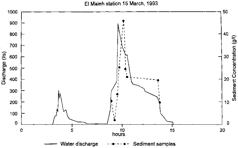
Observe the
high variation of discharge and solids concentration during the
ephemeral event
(Source: PAP/RAC-UNEP,
1997)
Table II-1. Sediment yield estimates for the event on 15 March 1993 at the El Maleh station
Samples |
actual values fit |
logarithmic fit |
||
5 min step |
daily flow |
5 min step |
daily flow |
|
all |
174 tm |
73.6 tm |
132 tm |
32.6 tm |
set A |
337 tm |
0.179 tm |
350 tm |
0.12 tm |
set B |
183 tm |
131 tm |
192 tm |
152 tm |
Computed after twelve different procedures regarding sampling (all samples or two subsample sets), curve- fitting technique (actual values or logarithmic values), and temporal integration of sediment-discharge rating formula (5-minute step or daily integration). Temporal integration can introduce a much wider error than interpolation procedure or sampling design.
4.2.4 General recommendations
The data handling and presentation procedures within the measurement project should provide:
a) A description of the original data obtained through the sampling programme, that include place, date and time, sampling method, water stage and discharge at the sampling moment. This is necessary in order to check the possible errors or mistakes in the sampling or measuring procedures.
b) A detailed analysis of some of the more representative events, especially to show the detailed hydrographs as well as suspended sediment concentration / liquid discharge relationships. This is necessary in order to analyze the main aspects of the erosion and transport processes active in the basins, in other words, to analyze the qualitative aspects of erosion and transport phenomena.
c) A detailed description of the steps used to interpolate and extrapolate the instantaneous sediment measures, as well as the procedure used for temporal integration of water and sediment discharges. Whenever possible, alternative methods of both procedures should be tested and presented in order to know the range of errors in the resulting estimates.
d) A description of water and sediment discharges that would contain an assessment of likely errors and make possible the analysis of temporal or seasonal differences.
e) A recapitulation of the information and findings relevant for subsequent usage by scientists, engineers and policy makers. This would include the statistics of the data obtained (water discharges, sediment discharges with an assessment of the errors, characteristic sediment concentrations in stream waters), as well as the main aspects of the goals and the problems suffered during the Programme (number of samples, total time of measured discharges, main problems with instruments, and directions to improve the method).