PART III
Resource papers presented at the consultation
Wetlands have been defined as areas that have free water at or on the surface for at least the major part of the growing season. The water is sufficiently shallow to allow the growth of a wetland crop or of natural vegetation rooted in the soil. Wetland ecology characterizes these areas by their surface water hydrology, their soil and terrain characteristics, and the prevailing climatic conditions (Brinkman and Blokhuis, 1986).
While some of the Africa's wetlands are believed to have good potential for expansion of agriculture to meet the food demands of the increasing populations, they are at the same time fragile lands which provide numerous products, services and functions. Because of the complexity of wetland ecosystems due to the variation of water level in time and in space, they provide important ecological functions and socio-economic services and products. Table 1 gives some of the important functions, products and attributes of wetlands (Harou, 1995).
TABLE 1
Wetland values
Functions |
Products |
Attributes |
Groundwater recharge |
Forest resources |
Biological diversity |
Groundwater discharge |
Wildlife resources |
Uniqueness to culture/heritage |
Flood control |
Fisheries |
|
Shoreline stabilization, erosion control |
Forage resources |
|
Sediment/toxicant retention |
Agricultural resources |
|
Nutrient retention |
Water supply |
|
Biomass export |
||
Storm protection/ windbreak |
||
Micro-climate stabilization |
||
Water transport |
||
Recreation/Tourism |
The fact that wetlands provide various functions and services in time and space implies that they often have temporal and spatial complementarity within traditional agro-ecosystems. During the flooding period, fisheries and other aquatic resources are used by traditional social groups, while in drier periods grazing and agriculture become the more predominant land-use systems. Wetlands
Parviz Koohafkan
Chief, Soil Resources, Conservation and Management Service (AGLS), FAO, Rome
Freddy Nachtergaele, Jacques Antoine
Technical Officers, Soil Resources, Conservation and Management Service (AGLS), FAO, Rome
are also important complementary land resources to the more hilly areas during the dry seasons when irrigated crop production ensures local food security for small farmers. Therefore, the conservation and management of the wetlands have to be considered in a broader context of integrated and sustainable natural resources planning and management. Sustainability refers to the ability of these agro-ecosystems to maintain their functions and production over time, in the face of the long-term ecological constraints and disturbances as well as the socio-economic pressures which will affect Africa's wetland areas in the future. The long-term consequences of interventions in these natural systems need to be carefully analysed to avoid the mistakes of the past decades, when agricultural research and agricultural development projects focused on investing most resources in developing and applying technologies that were often not appropriate to the socio-economic and cultural needs of the rural communities. Many of these projects pursued the objective of producing cash crops destined for export on lands with better agricultural potential. As a result, less land was used for growing basic food crops, especially on lands with good agricultural capabilities. As the better land was transferred to export crops, local farmers who did not own the land were forced to move on to less productive marginal lands or into areas with important ecological functions, thereby promoting further deforestation and ecological degradation of the land resource base. In addition, a preliminary agro-ecological zoning of the African wetlands reveals that the majority of these lands consist of marginal and problem soils and that their agricultural intensification and development would require important financial and technological investment which would not pay off the possible environmental and socio-economic impacts of such development.
It is understood, however, that dambos are agro-ecological systems of a different nature from the major wetland systems and, as such, they could be considered as potential land resources for sustainable agriculture. The majority of these lands are already in use by small farmers and their soils are Fluvisols or Vertisols with relatively good agricultural potential. The proposals of strategies for a sustainable management of these lands, which should include the maintenance of integrated and diversified production systems, would avoid un-planned intensification and further encroachment on more fragile wetlands eco-systems.
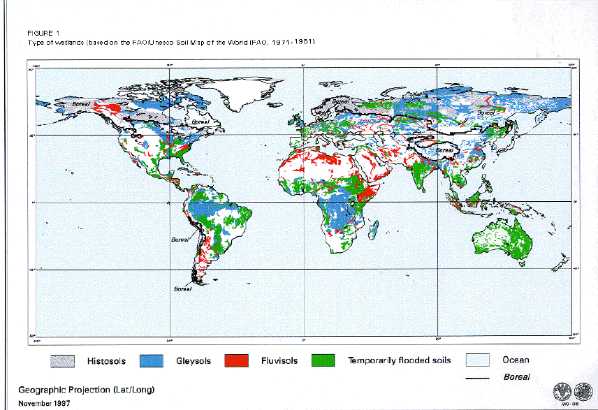
Hydromorphic soils and wetland conditions are recognized at the highest levels of classification in nearly all soil classification systems. The range in soil characteristics is so broad, however, that they can be subdivided into several very different types (Figure 1), which all require adapted management or protection techniques.
Histosols: peats and swamps
These are different from all other wetlands by their organic rather than mineral nature. They range from the moss peats of the boreal tundra, to reed/sedge peats and forest peats from the temperate zone, and the mangrove and swamp forest peats of the humid tropics.
The name `Histosols' originated from the Greek "histos" meaning tissue, connative of soils rich in fresh or partly decomposed plant materials. In other soil classification systems they are known as `sols hydromorphes organiques' (French), `Moorböden' (German), and `bog soils' (in Russia).
Histosols are formed of incompletely decomposed plant remains. They are characterized by a thick horizon that is rich in organic matter (generally more than 20%). They are generally formed as a result of very low temperatures or in very wet conditions, or both, throughout the year. Under these conditions the decomposition of plant debris is greatly slowed down with an accumulation of organic matter as a result.
Most Histosols are loosely packed in their natural state, and virgin peats retain considerable quantities of water. The specific density of Histosols is of particular importance as the total pore volume greatly influences the bearing capacity of the soil and its trafficability, and the rate of subsidence when drained.
The range in their pH values is very wide: alkaline peats with a pH of over 7.8 were reported in the Maldives, while extremely acid Histosols with pH values of less than 2 may occur when peats containing pyritic materials are drained. Cation exchange capacity of peats is generally very high, with values reported between 100 and 200 cmol/kg soil.
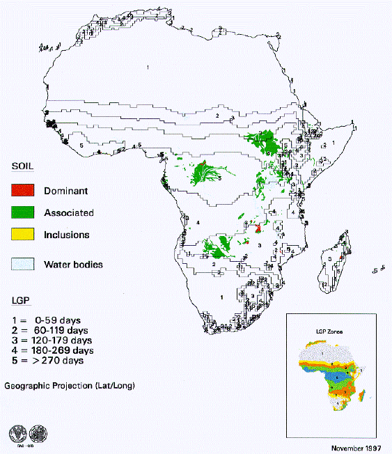
The total extent of the Histosols in the world is about 275 million ha (FAO, 1991b) illustrated in Figure 1 (world) and Figure 2 (Africa), with more than half occurring in boreal and cold climates in northern Finland, western Scotland, Central Canada, Alaska and east of the Ural mountains in Siberia where they occur in association with Gleysols (see following section).
In these cold climates their present agricultural potential is very low and most of them remain under their natural vegetation cover of low bushes and scattered trees. Many of those have a permanently frozen layer at some depth. It should be noted that under most scenarios of global warming this area will most certainly be subjected to thawing influences and huge areas of wetlands with better environmental conditions may be created in this region.
In temperate and cool (highland) tropical regions a distinction is often made between those Histosols under permanent influence of groundwater that occur in low-lying positions in fluvial, lacustrine and marine landscapes (low moor peats), and those that formed in conditions of high precipitation (high moor peats).
When these peats occur in extremely wet conditions in warmer climates under a climax rain forest vegetation, such as the peats and swamps of Angola, Papua New Guinea, northern Sumatra, Bangladesh or Guyana, their agricultural potential is limited by waterlogging, poor nutrient status and low bearing capacity, combined with the lack of a stable system to fix roots. However, when they are carefully drained, they offer some potential for dryland crops. These are the most fragile wetlands and the general guideline should be to protect rather than develop them.
Gleysols: mineral soils of wetland
Gleysols are the most typical mineral wetland soils. Their formation is conditioned by waterlogging at shallow depth for some or all of the year. The prolonged saturation of soils by groundwater in the presence of organic matter results in the reduction of iron that is partly leached out of the soil and forms a grey, olive or blue-colored subsoil horizon. Subsequent re-oxidation takes place in the fissures or cracks in the soil and yellowish or reddish mottling may appear, often in combination with blackish concretions of iron and manganese.
|
FIGURE 2
|
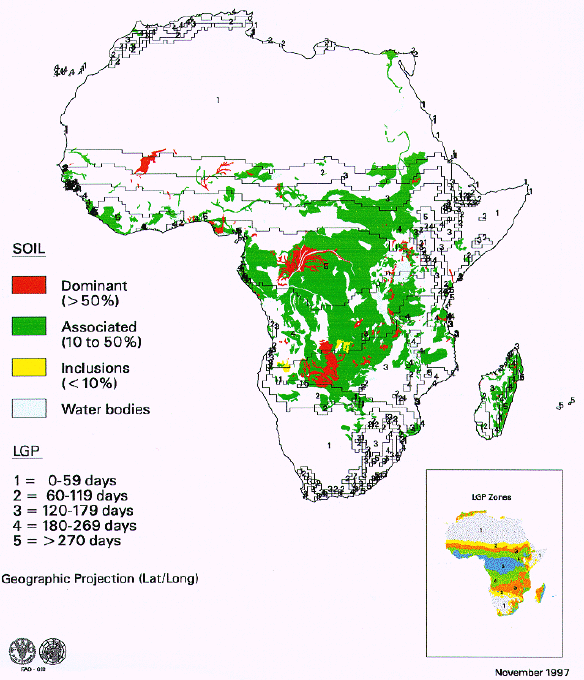
The name `Gleysol' originated from the Russian word "gley", meaning mucky soil mass. Other names in other classification systems are: `sols à gley' or `sols hydromorphes' (French), `Auenböden' (German), `Aquepts' and `Aquents' (USA), `meadow soils' (in Russia).
The total area of Gleysols, illustrated in Figure 1 (world) and Figure 3 (Africa), is estimated at about 720 million ha, of which 300 million ha occur in boreal and polar climates, where these soils have a permanently frozen layer at shallow depth and have no agricultural potential at present. However, they are very important for wildlife preservation.
The remaining Gleysols occur in the lowland tropics and subtropics, associated with alluvial soils where they are extensively used for bunded rice growing. For other arable cropping, dairy farming, horticulture or tree crops the water table must be lowered by draining. Their potential therefore largely depends on the flooding regime and the possibility to drain them, rather than on their soil characteristics, which may be quite variable.
Important soil features include the depth to the reductimorphic layer and the extent of the groundwater movement within the soil. The textural classes of Gleysols are often sandy or loamy, sometimes clayey. Their pH varies between 2.5 (under mangrove) and 9.5 (in soils with sodic properties). Corresponding base saturation values may vary between 10 and 90 percent. Soil structure and clay mineralogy of Gleysols are very variable with the blue-green rust often characterized by siderite and vivianite (iron hydroxides and sulphides). The main chemical process in Gleysols is the transport of reduced Fe2+ and Mn2+ ions by capillary forces and their oxidation.
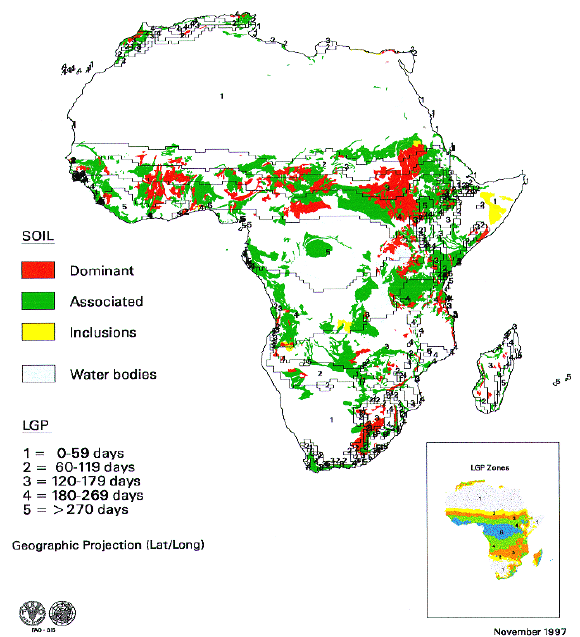
Fluvisols: hydromorphic soils of alluvial flood plains
Soils developed in recent fluviatile, lacustrine or marine deposits, particularly in periodically flooded places, occur in all climates and are widely distributed. Only major occurrences can be shown in Figure 1 (world) and Figure 4 (Africa), either mainly in the great river deltas, where these soils are dominant, or where they are associated with the main wetlands (Gleysols).
The name `Fluvisols' is derived from the Latin "fluvius", river. In other soil classification systems they correspond with `sols peu évolués d'apport alluvial' (French), `Auenböden' (German), `Fluvents' (in USA) and `alluvial soils' (in Russia).
All Fluvisols have in common that they receive fresh sediments and hence are regularly rejuvenated: they often show stratified layers and an irregular distribution of organic matter with depth. Otherwise their characteristics vary from fine to coarse textured, from acid to alkaline, from rich to poor in nutrients. However most Fluvisols are fertile and are on flat, easily worked land. Fluvisols are often wet in all or part of the profile due to the presence of groundwater or flood water from rainfall, rivers or tides, Some Fluvisols, those developed in marine or brackish water sediments, contain pyrite and may turn extremely acid on drainage. The total area of Fluvisols is estimated at 355 million ha in river plains (Amazon basin, Ganges Plain), in deltaic areas (Nile, Ganges-Bramaputhra, the Red River, and the Mekong) , and in coastal lowlands with recent marine deposits (West Africa, Indonesia, Viet Nam, The Netherlands). The narrow strips of Fluvisols which border most streams and drainage ways often have an importance much greater than their extent, because they provide dry season grazing or sites suitable for paddy rice.
|
FIGURE 3
|
|
FIGURE 4
|
Fluvisols are very productive for a wide range of dryland crops and paddy rice on the various parts of the floodplain: the river levees and terraces. Tidal lands with acid sulphate soils are normally under mangrove in the tropics and under grassland in more temperate climates, but have been extensively reclaimed in some areas including Thailand, Surinam and Indonesia.
Soils that are seasonally flooded
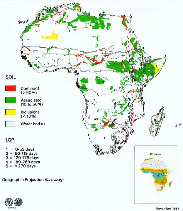
A number of hydromorphic soils are only seasonally flooded when they are found in particular positions in the landscape. It has been a matter of some debate to include them or not in various inventories dealing with wetlands. This concerns in particular the case of Vertisols, soils rich in cracking clays, locally known as dambos. mbugas or black cotton soils. Other soils characterized by an impermeable clayey subsoil layer are Planosols, which are often seasonally wet through episaturation. Other soils affected by flooding to a lesser extent than Gleysols are soils with gleyic properties or with plinthite (plinthite is a layer rich in clay and iron which irreversibly hardens on drying and is often an indication of seasonal wetness). The distribution of these seasonally flooded soils is illustrated in Figure 1 (world) and Figure 5 (Africa).
Vertisols (`dambos', `mbuga' soils)
The main characteristic of Vertisols is their high content of smectitic clays which shrink and swell according to the soil moisture conditions : they are sticky and plastic when wet, often impassable under these conditions, and very hard with a cracked (and often deformed) surface when dry. Sometimes they develop a very granular self-mulching layer on top. These soils are generally very rich chemically but are very difficult to manage given their physical properties.
The total global area of Vertisols is estimated at 340 million ha, mainly in India, central Sudan, southern and eastern Africa, eastern Australia and Texas (USA).
Vertisols have a significant agricultural potential but not for subsistence agriculture as they have workability constraints. Unless mechanization, irrigation and drainage are feasible, they are best suited for grazing. Cotton is known to perform well on these soils, but needs an agro-industrial base.
Planosols
Planosols are soils which have a coarse textured layer abruptly overlying a deeper dense horizon with significantly more clay. Planosols often occur in water receiving sites on flat to gently undulating terrain. They cover about 130 million hectares worldwide with important concentrations in Brazil, South Africa and eastern Australia.
The main constraints of these soils are the low structural stability of the surface horizon, the compaction of the subsoil and the seasonal waterlogging alternating with drought stress. They are very difficult to manage or to improve. They can best be left to extensive grazing, although some timber production or rice cultivation is possible, provided fertilizers and careful water management are guaranteed.
|
FIGURE 5
|
Plinthic and Gleyic soils
Gleyic soils have similar characteristics as Gleysoils but the water table remains deeper and hence they are less hydromorphic and only seasonally saturated.
Plinthic soils are tropical soils that contain a mixture of iron and clay that irreversibly hardens into ironstone concretions when dried. Globally there are about 60 million ha of Plinthisols mainly in Brazil and West Africa. Many of these soils are seasonally wet or flooded. They are very poor soils nutrientwise, with high contents of iron and aluminium oxides, but have potential as a source for low grade ore and bricks. The agricultural use of Plinthosols is generally limited to extensive grazing or forests, or for fuelwood production.
Table 2. and Figures 1 to 5 give an overview of the distribution of the different wetland soils in the various agro-ecological zones in Africa.
TABLE 2
Distribution
of wetlands by agro-ecological zones in Africa
|
Soil |
|
|
LGP (days) |
|
|
Subtotal and total |
|
|
0-59 |
60-119 |
120-179 |
180-269 |
>270 |
km2 |
|
HISTOSOLS |
|
|
|
64 |
|
|
|
Inclusions |
|
|
|
|
64 |
|
|
SUBTOTAL |
|
|
|
|
|
128 |
|
Associations |
2,833 |
|
|
|
|
|
|
Associations |
|
2,857 |
|
|
|
|
|
Associations |
|
|
62,207 |
|
|
|
|
Associations |
|
|
|
57,835 |
|
|
|
Associations |
|
|
|
|
70,096 |
|
|
SUBTOTAL |
|
|
|
|
|
195,828 |
|
Dominant |
|
|
7,561 |
|
|
|
|
Dominant |
|
|
|
468 |
|
|
|
Dominant |
|
|
|
|
1,348 |
|
|
SUBTOTAL |
|
|
|
|
|
9,377 |
|
Square km |
2,833 |
2,857 |
69,768 |
58,367 |
71,508 |
205,333 |
|
GLEYSOLS |
|
|
415 |
|
|
|
|
Inclusions |
|
|
|
1,827 |
|
|
|
SUBTOTAL |
|
|
|
|
|
2,242 |
|
Associations |
48,186 |
|
|
|
|
|
|
Associations |
|
106,412 |
|
|
|
|
|
Associations |
|
|
340,491 |
|
|
|
|
Associations |
|
|
|
492,212 |
|
|
|
Associations |
|
|
|
|
479,934 |
|
|
SUBTOTAL |
|
|
|
|
|
1,467,235 |
|
Dominant |
7,151 |
|
|
|
|
|
|
Dominant |
|
38,861 |
|
|
|
|
|
Dominant |
|
|
101,696 |
|
|
|
|
Dominant |
|
|
|
48,004 |
|
|
|
Dominant |
|
|
|
|
118,759 |
|
|
SUBTOTAL |
|
|
|
|
|
314,471 |
|
Square km |
55,337 |
145,273 |
442,602 |
542,043 |
598,693 |
1,783,948 |
|
FLUVISOLS |
|
|
|
|
|
|
|
Inclusions |
12,969 |
|
|
|
|
|
|
Inclusions |
|
137 |
|
|
|
|
|
Inclusions |
|
|
73 |
|
|
|
|
Inclusions |
|
|
|
44 |
|
|
|
SUBTOTAL |
|
|
|
|
|
13,223 |
|
Associations |
422,317 |
|
|
|
|
|
|
Associations |
|
107,213 |
|
|
|
|
|
Associations |
|
|
148,002 |
|
|
|
|
Associations |
|
|
|
185,470 |
|
|
|
Associations |
|
|
|
|
115,767 |
|
|
SUBTOTAL |
|
|
|
|
|
978,769 |
|
Dominant |
124,491 |
|
|
|
|
|
|
Dominant |
|
64,997 |
|
|
|
|
|
Dominant |
|
|
101,629 |
|
|
|
|
Dominant |
|
|
|
75,784 |
|
|
|
Dominant |
|
|
|
|
17,641 |
|
|
SUBTOTAL |
|
|
|
|
|
384,542 |
|
Square km |
559,777 |
172,347 |
249,704 |
261,298 |
133,408 |
1,376,534 |
|
TEMPORARILY |
|
|
|
|
|
|
|
Inclusions |
5,911 |
|
|
|
|
|
|
Inclusions |
|
|
440 |
|
|
|
|
Inclusions |
|
|
|
1,969 |
|
|
|
SUBTOTAL |
|
|
|
|
|
8,320 |
|
Associations |
128,467 |
|
|
|
|
|
|
Associations |
|
161,751 |
|
|
|
|
|
Associations |
|
|
333,224 |
|
|
|
|
Associations |
|
|
|
465,289 |
|
|
|
Associations |
|
|
|
|
148,322 |
|
|
SUBTOTAL |
|
|
|
|
|
1,237,053 |
|
Dominant |
62,659 |
|
|
|
|
|
|
Dominant |
|
161,008 |
|
|
|
|
|
Dominant |
|
|
383,803 |
|
|
|
|
Dominant |
|
|
|
373,963 |
|
|
|
Dominant |
|
|
|
|
54,041 |
|
|
SUBTOTAL |
|
|
|
|
|
1,035,474 |
|
Square km |
197,037 |
322,759 |
717,467 |
841,221 |
202,363 |
2,280,847 |
|
Land extent Africa |
|
|
|
|
|
29,899,683 |
The total extent of wetlands in Africa amounts to about 5.6 million km2 or about 16 % of the total area of the continent. If only the major wetland soils are considered the total extent is about 3.4 million km2 (9 -10% of the continent). When the distribution by major growing period zone is considered there is a particular interest in wetlands of arid and semi-arid areas in which especially the Fluvisols may play an important role. Indeed valleys and deltas such as those depending on the Nile and the Niger rivers are of particular importance for agriculture and feed an important part of the population under the Sahel and Saharan conditions. To a lesser extent, but also important for a highly specialized form of agriculture are the wadis and oases inventoried in these areas, particularly in northern Africa. A small part of these alluvial soils are showing particular characteristics of acidification and are under mangrove (Casamance, The Gambia); these areas are rather unique habitats and should be considered for preservation rather than development. At the other end of the spectrum, the wetlands inventoried in the humid agro-ecological zones (LGP> 270 days) have a less important role to play for agriculture, but are particularly important from a biodiversity point of view, and should be considered for preservation rather than subject to development.
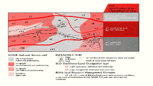
In rural planning with an agricultural production and/or environmental protection focus, zoning is an intermediary product in the land-use planning process. This zoning itself involves a subdivision of the land on the basis of the physical and biological or agro-ecological characteristics of the various natural land units, primarily climate, soils, landform, land hydrology, land cover and land use as well as the prevailing socio-economic conditions. Together they form the basis for the delineation of land resource management domains (RMD) (Sombroek, 1994). The RMD integrates all elements of the physico-biotic environment included in agro-ecological zoning (AEZ) with the socio-economic environment. It then matches them through multiple goal analysis, thereby providing a neutral tool for the various stakeholders (land users) to simulate use and management scenarios and negotiate a consensus on the optimal use or non-use of the land to be subsequently executed through legislative, administrative and institutional action on demarcated spatial units (Figure 6). As the information is geo-referenced and has no hierarchical order the zoning is flexible and can be matched with specific priorities given to specific issues. The AEZ/RMD approach is based on three guiding principles (Brinkman, 1994):
FIGURE 6
|
Conservation of the production potential and maintenance of the essential functions and attributes of the wetlands. This implies that wetlands are allocated to uses for which they are suitable, and used under appropriate management practices to ensure that these resources are conserved and that the surrounding environment is protected from the adverse impacts.
RMD has no a priori bias towards high-input and intensive agricultural land use but considers a wide range of uses, including traditional production systems, which may satisfy the objectives of the land users and the environmental requirements linked to sustainable use of the wetlands. The use of multiple goal analysis enables the simulation processes and examination of many use options and the ranking and periodic reassessment of the objectives of stakeholders, and subsequent optimization will support stakeholders' decisions towards sustainable uses of the defined area (Antoine et al., 1997).
The principal aims of delineation of the RMDs are as follows:
The potential benefits of RMDs are the following:
RMDs deal with land resources as well as people and their social organization. These people comprise the actual or potential land users, which may consist of individuals, communities or governments that have a traditional, current or future right to decide on the use of the land. An essential element of RMDs is their dynamic character; they can and should be redefined or adjusted in relation to changing socio-economic conditions of the area concerned and outside influences, such as local and regional market trends.
The RMD concept is applicable at all geographic scales and for lands of any intensity of use. It is used for large tracts of land such as major river catchments and physiographic regions that have as yet a sparse human population as well as delineation of land management units in detailed scale land-use plans at local area level. RMD is applicable to multi-scale land-use planning. A typical design involves province or district level land-use plans with large land management areas, within which village land-use management plans at detailed scale and for areas of interest are nested. In this sense RMDs are important elements of interactive land management, including wetland management..
Methodology for delineation of RMDs
The procedure proposed is similar to a procedure developed and applying in Brazil for agro-ecological and economic zoning (Sombroek, 1994). The procedure involves four main steps:
Collection of maps and spatial information and entry into GIS
Pre-zoning activities
Zoning sensu stricto
Post-zoning: interactive/participatory land management
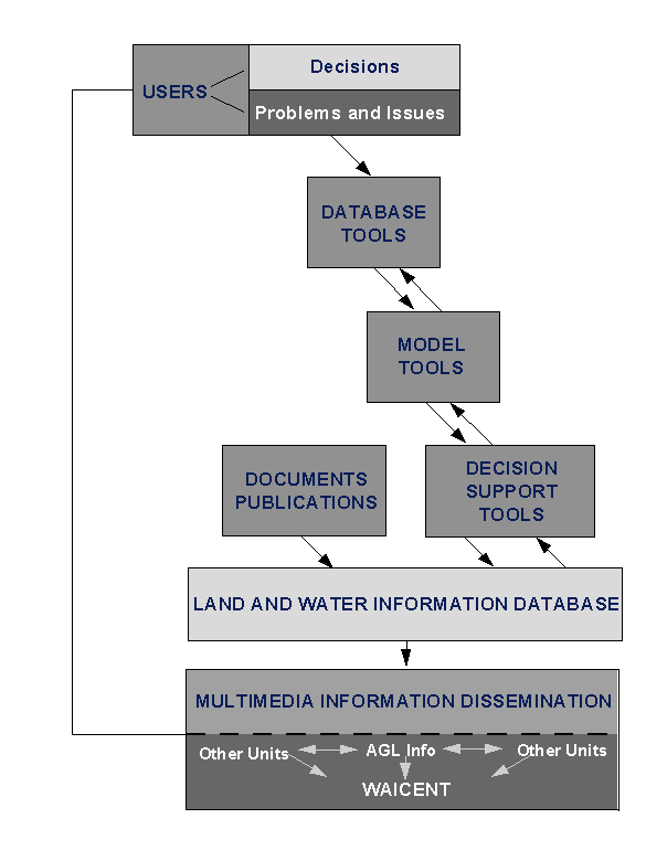
Over the last two decades the Land and Water Development Division (AGL) of FAO has been at the forefront of the development and application of computer-based systems to analyse data and generate information to support decisions on many aspects of land and water issues. Rapid development of information technology in the last decade has also created a unique opportunity for FAO to integrate AEZ and RMD tools into computerized systems called land and water resources information and decision support systems (LWRIS). In particular, the systems have been used to analyse issues related to sustainable use of land and water for food production and food security at global, regional, national, sub-national and local levels. For the development, application and implementation of these systems, FAO has been cooperating with various units within FAO and numerous international agencies and national institutions. This tool can be applied for characterization and classification of wetlands and can be available with related training packages to countries and institutions.
LWRIS are designed as flexible multi-purpose attribute systems which can be used to generate quickly and economically the information products, including images, maps, tabular and textual reports for the elaboration of various other kinds of information useful for land-use decision. LWRIS multi-use resource databases can usually support a wide range of applications. Currently, these systems comprise a set of tools to store and analyse information and generate and disseminate information products for land and water decisions. The tools essentially integrate five components (Figure 7):
|
FIGURE 7
|
1) Database tools
These include database program shells for the creation of soil, water, climate, crop and land-use database, and sometimes also the databases which have been established using the programs. Increasingly used are geographic information system (GIS) databases and analytical and visualization tools for rapid production of information products. GIS utility derives from a capacity for dynamic functionality based on the following three main qualities:
2) Model tools
3) Decision support tools
4) Documents and publications
AGL has a Documentation Centre which collects and maintains two kinds of documents:
AGL uses an adaptation of the ISIS software to manage the database of the Documentation Centre. The system allows searches and compilation of lists by continent, region, country, subject, author, year, etc. and requests for information can be answered at once. Printouts of what is available for consultation can be provided. Recently the database has been improved by installing an updated version and making an interface which allows quicker printing of lists.
This Documentation Centre has a direct link with FAO's Main Library databases (FAOBIB and SERIAL) and uses on-line Virtual Library databases (AGRIS, CABI, etc.) for more comprehensive searches: loans, internal circulation of documentation, books, serials; dissemination of information and publications. The Centre provides reference and information services to internal staff, field staff, external research workers and university students, and can make computerized literature and map searches using internal databases.
5) Multi-media tools
AGL uses INTERNET and INTRANET facilities to disseminate information under the umbrella of the World Agriculture Information Centre (WAICENT). WAICENT is FAO's Corporate Information Dissemination System. In this way AGL reaches its target audiences more effectively at reduced processing costs in all phases of receiving, treating and disseminating information.
AGL takes advantage of the three principal interactive and complementary components which makes up WAICENT:
In particular AGL uses the services of the FAOINFO Group of WAICENT to prepare the textual, graphical, statistical and tabular information which are placed on the Web.
Integrated approach to wetland resources planning and management
|
FIGURE 8
|
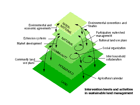
An integrated approach to sustainable wetland management could be effective and operational if it takes into account the needs and aspirations of the present and potential users of these lands and if it is based on the existing local, traditional agro-ecosystems that have enabled the mostly resource-poor small farmers to meet their subsistence needs for centuries without adverse environmental consequences. The traditional knowledge of local farmers, which often reflects experience gained from the past generations, should continue to form the basic foundation of agriculture and farm management in wetlands. An integrated approach incorporating sound traditional agricultural practices is more likely to contribute to the establishment of ecologically sound management practices that are understandable and acceptable to the concerned rural communities. Cultural factors other than yields and economic profitability are equally important in determining sustainable productivity of the agricultural systems. This approach also takes into account the level of intervention and particularly interactions between sectors at different scales of the intervention both vertically and horizontally (Figure 8). It will also imply an effective negotiating process involving all the stakeholders through a participatory process which does not deny the rights and responsibilities of each party. This is indeed a complex and resource consuming process which would also need information, knowledge and empowerment tools for the local people which are not readily accessible. From the technical point of view the integrated approach includes the characterization of the wetlands in terms of agro-ecological zones and RMD and multi-criteria analysis and optimization scenarios through participatory land-use planning.
Effective negotiation and decision making on wetland use cannot take place without a knowledge base that is accessible and usable for all stakeholders. The two essential components of the knowledge base are information and education to make the information accessible.
Much information is available regarding the specific problems of soil characteristics, land productivity and water management and the methods to conserve the land and water resource base. However, the information needs are becoming more diverse, growing rapidly both in quantity and quality as the spatial, environmental and socio-economic aspects of an increasingly complex world are considered. In the prevailing conditions of growing needs in all sectors and rapid change in various countries, the informal, gradual accumulation of local experience as a basis for planning and management decision becomes a slow and expensive process. Decisions are being taken without proper consultation and an adequate knowledge base, and conflicting demands are often the source of the misuse of the resources. More formal and rapid methods of information gathering and interpretation are then needed to support decision making with a broader and more systematic information base. Information required is geo-referenced, i.e. location-specific, and represented in the form of data and maps with two- or three-dimensional coordinates. This includes information on topography, landform, soil, climate, water availability and use, water quality, land use and cover, arable land, land suitability, land productivity, population, presence of diseases (e.g. trypanosomiasis), infrastructure, land tenure, etc. Table 3 summarizes some of the main issues related to sustainable land and water resources management at various levels.
TABLE 3
Scales of
land and water use planning and management
|
Level of analysis |
Scale/spatial resolution (*) |
Issue |
|
Field/production unit (site specific) |
<1:5 000 |
|
|
Farm/village (local/level) |
1:1 000-1:50 000 |
|
|
Country (national/ sub-national) |
1:25 000-1:2 500 000 |
|
|
Continent/world (regional/ global) |
1:1 000 000-1:5 000 000 |
|
(*) A range of scales is indicated at any given level of analysis. In practice the actual scale of an application is selected according to the extent of the area and the availability of maps.
Remote sensing techniques can be used to characterize and map land-use patterns and monitor wetland conditions. Evaluation of the effects of land-use changes on the conditions of the wetlands is essential to determine the sustainability of the practised land uses in wetlands. This will assist in determining correctives measures to apply in successive wetland management activities to preserve the essential biodiversity values.
Wetlands are fragile ecosystems which provides multiple ecological and socio-economical products, services and functions. They need an integrated approach to their planning and sustainable use. Policy and technical tools are needed to counteract lack of appropriate information and intervention failure which cause wetlands to be used in an unsustainable way.
In the seasonally dry tropics and subtropics (LGP 120 - 270 days) the highest concentration of wetlands occurs. However, given the major limitations of the majority of the Wetland soils, only few can be developed at low cost. This concerns in particular the alluvial soils of inland valleys and Vertisols (dambos) (about 500 000 km2). All other wetland soils in these regions will require considerable investment and management skills to develop and maintain productivity, which should also be carefully balanced against the preservation of unique habitats and hydrological functions of these wetlands. The areas of small wetlands and inland valleys which could be considered for a sustainable agricultural use concern in particular the dambos, the Gleysols and the gleyic units. It is recommended to discourage the use and development for agriculture of other soils and particularly the majority of Planosols, Plithic soil, and Histosols. The majority of wetlands occurring in tropical rainforest areas, and wetlands containing Histosols, Planosols and Plinthisols, should be preserved at all costs. This concerns at least half of the wetland area inventoried.
About 750 000 km2 of alluvial wetland soils are of particular importance for agricultural development in the drier parts of Africa. Many if not all of these soils are already intensively used for agriculture (Nile and Niger plains and deltas). Another 1 million km2 of Gleysols, 500 000 km2 of alluvial soils and perhaps 500 000 km2 of Vertisols are probably suitable for cultivation provided high investments and management levels are applied. In each individual case it is highly recommended to consider long-term environmental and sustainability issues prior to development.
A final consideration in this respect, which transcends the boundaries of the African continent, is the fact that, considered on a global scale, the majority of wetlands occur in boreal and polar climate. Most of these are Gleysols and Histosols (peats). These areas will take on a special importance in scenarios considering global warming, particularly when the peats may act as a CO2 source.
Desirable land use must be attained based on a proper evaluation of land capabilities, sound economics, and a political consensus on ideal land use. Characterization and classification of these ecosystems could benefit from the FAO LWRIS tools which have several components and include AEZ, RMD, multi-criteria decision support and simulation and optimization through participatory land-use planning, and also electronic multimedia tools for dissemination of information to the stakeholders and users.
Andriesse, W. et al. 1994. Multi scale characterization of inland valley agro-ecosystems in west Africa. Netherlands Journal of Agricultural Science 42. 20 p.
Antoine, J. et al., 1997. Multiple criteria land use analysis. Applied Mathematics and Computation, 83:195-215. Elsevier Science, New York.
Brinkman, R. 1994. Recent developments in land use planning, with special reference to FAO. pp 1122. In: Fresco et al. 1994.
Brinkman, R. and Blokhuis, W.A. 1986. Classification of the soils. In: The Wetlands and Rice in Subsaharan Africa. Juo, A.S.R. and J.A. Love (eds.). IITA, Nigeria.
FAO. 1971-1981. FAO-Unesco Soil Map of the World. Vols. I-X. Unesco, Paris.
FAO. 1978. Report on the Agro-Ecological Zones Project. Vol.1: Methodology and Results for Africa. World Soils Resources Report 48/1. FAO, Rome.
FAO. 1991a. Agro-Ecological land resources assessment for agricultural development planning: A case study of Kenya. World Soils Resources Report 71/1-9. FAO, Rome.
FAO. 1991b. World soil resources. Explanatory text for the World Soil Resources Map at 1:25M scale. World Soil Resources Report 66. FAO, Rome.
FAO. 1995. Planning for sustainable use of land resources: towards a new approach. Land and Water Bulletin 2. FAO, Rome. 60 p.
Harou, P. 1995. Wetlands economics and land use. In: Environmental and Land Use Issues, CIHEAM-EAAE. 540 p.
ISCO, 1996. Precious Earth, from Soil and Water Conservation to Sustainable Land Management. ISCO, Berne. 90 p.
Sombroek, W.G. 1994. Introduction to the Philosophy, Concepts and Methods of Ecological-Economic Zoning. Manaus Workshop on Ecological-Economic Zoning in the Amazon Region, 25-29 April 1994. FAO, Rome.