![]()
![]()
![]()
D.B. Dhittal
Head, Forest Resources Development Division
Department of Forestry Services
Bhutan
INTRODUCTION
Scientific management of forests started in Bhutan with the preparation of first forest management plan in 1964. The first plan was prepared for Sarpang forest division. The duration of the plan was for ten years (1964-65 to 1973-74).
One year later, a second working plan for Samtse forest division was prepared. These plans have been prepared meticulously, as during those days, there were lot of difficulties in getting reliable data. However, both the plans lacked, very much, in socio-economic information of the area. It was very difficult to collect information. It was further aggravated by the difficult terrain and the varying reliability of the information.
During the seventies, the Department of Forestry Services (DoFS) prepared management plans with the technical assistance from UNDP/FAO Projects. The plan prepared under the technical assistance of this Project was for Chimakoti forest management unit. The duration of the plan was for a period of ten years (1976-77 to 1985-86). The format of the plan was very simple and reduced. However, some of the required information was lacking. The plan also did not take care on the social aspect for the people living there. The usufruct role of the forest, the local peoples' dependence on the nearby forest etc. were not considered.
Only from the beginning of the nineties, there was a slight shift in the management planning system. More considerations were given to the social aspects besides the ecological and economical aspects. Effort were made to collect reliable information from various stake holders The prescriptions were drawn based on the forest functions, which were identified in the field and mapped.
MANAGEMENT PLANNING
As required by the National forest Policy, the aim is to bring the government reserved forest of the country under effective and scientifically prepared forest management plans. To achieve this requirement, approved forest management plans are pre-requisite for any commercial harvesting of forest produce. Therefore, the forest management plans are prepared with primary objectives of achieving the followings:
conservation of the fragile environment of the country;
ensuring a sustainable supply of timber, fuelwood and animal grazing and non-timber forest products for the local consumption; and
allocating sustainable forest products in excess of local needs to promote value-added forest based industries.
A number of important criteria have been developed to guide the development of these forest management plans in order to achieve the above mentioned objectives:
Managed forests should attempt to satisfy local requirements for timber, fuelwood, grazing, fodder, compost litter and other traditional uses as a first priority.
Forest will be managed for long term sustainable yield, with allowable harvest calculations based on a detailed forest inventory and scientific growth and yields studies.
Forest harvesting systems should ensure environmental protection by minimizing soil erosion and land degradation, protecting natural drainage systems and avoiding permanent changes in the composition of vegetative species.
Forest management should be holistic and should consider not only the production of forest commodities but also watershed protection, wildlife conservation, maintenance of biodiversity and social uses.
Silvicultural systems should ensure regeneration of the principal species by natural means and only if natural regeneration is not obtainable should artificial regeneration techniques be adopted.
INFORMATION FOR FOREST MANAGEMENT PLANNING
Collection of reliable data is an important tasks for preparing sound forest management plans. In Bhutan, the type, content and the detail of data gathered differ among the functional and territorial divisions of the Department of Forestry Services. Functional divisions like the Nature Conservation Division and Forest Resources Development Division mainly collect data to provide information for preparing management plans and also to provide statistics on forest resource status. Territorial Divisions and the Forest Protection and Utilization Division collect data on forest utilization and offense cases. The Forestry Development Corporation collects information on the resources availability and the market trend.
TYPES OF INFORMATION
Broadly, the following types of information are collected:
Information on forest Resources;
Information on socio-economic status of the people living in and around the forest management units; and
Information on the ecological condition of the forest.
INFORMATION ON FOREST RESOURCES
Forest resources inventory
Selection of the Area
The area to be inventoried is selected based on field survey. Economic, ecological and social criteria are considered while selecting the area for Forest Management Unit.
Data Collection
All possible data are collected in order to provide a sound base for decision making in management planning. The data collection is divided into three separate parts. Each part is described briefly below. The data are collected using the following formats:
Forest resources data using format (see annex);
Forest functions mapping within the management unit; and
Socio economic data using the format (see annex).
Each of the data collection methods and results are discussed separately in this paper.
Inventory Design
While designing the inventory, the following points are considered
the objectives of the inventory;
the accuracy desired;
the extent and nature of the area;
condition of the forests; and
costs.
The forest resources inventory has the following objectives:
to provide a relatively accurate overview of the growing stock and regeneration potential of the natural forest in the area, according to major forest types;
To give an overview of the general site characteristics of the natural forest, in terms of soils, non-tree vegetation and use by local people; and
to provide an indication of timber quality in the different forest types;
to furnish essential data on tree height to enable the construction of local volume tables for the main species.
Therefore in order to capture the above mentioned information, the field works are geared accordingly to collect the following information:
(i) species found in the area (ii) trees (iii) stand types (iv) volume per hectares (v) basal area per hectares (vi) periodic annual increment per hectare, (iii) site condition of the area.
The inventory is designed aiming at sampling error of ± 10% at confidence level of 95%. The number of sample plots are calculated using the formula given below:
n = ( t2 * CV2 ) /SE%2.
Where,
n = number of sample plots required,
t = t distribution ( at df = α, p= 0.05)
CV = Coefficient of variation (The average value of coefficient of variation is taken to be 85%).
SE = Sampling error (SE % was taken to be 10%).
Location of Sample Plots
The sample plots are usually located in a North-South direction. This is to facilitate easiness in working especially in the mountainous area. The detail is shown in the following figure.
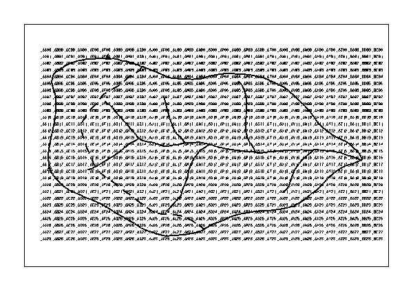
Sampling grid as generated by the GIS for the example FMU.
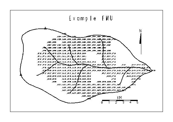
Sample plots that are actually to be measured, since they fall in land use categories defined as accessible natural forest.
Data recording on sample plots
The data, on each sample plot, are recorded on format. The details of each parameter are briefly given below:
Name of the inventory unit
Plot number
Any special observations
Altimeter reading
Land use type
Canopy height
Canopy closure
Accessibility
Aspect
Stand condition
Non-tree vegetation
Sign of commercial wood extraction
Sign of domestic wood extraction
Sign of grazing
Fire
Shifting cultivation etc. etc.
Stoniness cover
Depth litter + humus
Top soil colour
Top soil moisture
Top soil texture
Wildlife observation was done only in the major plots.
Identification of the different species of animals; or
Recording the evidence of a particular species based on the signs.
Regeneration is recorded on the regeneration plots only. Recording is done for 1.30 m height and up to 9 cm dbh. for the commercially valuable species.
Selection of trees for measurement
After recording the general plot information as described in the above-mentioned paragraphs, and field verification that the plot is accessible and falling in the natural forest, the other data are collected from the measurement of live trees having a dbh of 10 cm. and more. The sample plot, used in Bhutan is a combination of 3 overlapping circular sub-plots as shown in the following figure.
regeneration plot
radius=3.57 m
![]()

![]()
minor plot
radius=5.64 m.
![]()

![]()

Combined plot
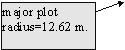
Size and shape of the sample plots
The specifications for the constituents concentric sub-plots (fig. above) of the sampling unit are given in the following table.
Sub-plot |
radius(m) |
area (m2 ) |
area (ha.) |
dbh of 'in' trees |
Regeneration |
3.57 |
40 |
0.004 |
0-9, taller than 1.30 m. |
Minor |
5.64 |
100 |
0.01 |
10-29 cm. |
Major |
12.62 |
500 |
0.05 |
30+ cm. |
Specifications for the constituents concentric sub-plots of the sampling unit.
Diameter measurement
Diameter at breast height (dbh) of all the sample trees are measured at 1.30 metres height from the ground level using the diameter tapes.
Height measurement
Total tree height measurement is done only in the special plots. Every fourth plot is identified as a special plot. Tree height is measured using the clinometres and entered in the tally sheets.
Development of maps
Updating of the existing topographic maps is usually done for every Management Unit All the basic data, obtained from aerial photographs, are recorded in map of 1:50,000 scale. These data are, then, digitized using the computer technology known as geographic information system (GIS technology). The other required maps are produced using the software ARCINFO in GIS.
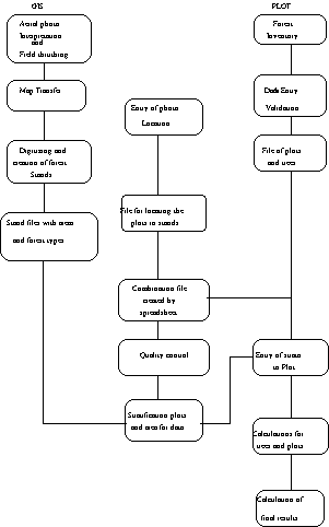
Chart 1 : Flow chart for calculation of inventory result.
Data compilation of the field inventory is one of the most important tasks for preparation of the management plan. The forest resources inventory data provide an idea of the quantity of timber available in the particular management unit. For analysing the result, a special computer program has been used known as <PLOT>. The following steps explain the procedure adopted for calculating the result after the data are collected from the field.
Data Entry:
After completing the field work, the data recorded in the tally sheet are entered into the computer using the input main menu option of <PLOT> system. The data from the tally sheets ends up in the database files, viz. PLOT.DBF, SITE.DBF, TREES.DBF, REGENER.DBF AND WILDLIFE.DBF. The databases for particular inventory are kept in a sub-directory of <PLOT> for future use. <PLOT> programme can checks for common errors during data entry, such as wrong codes as well.
Manual Data Correction:
As soon as data entry in the computers is completed, a hard copy is produced to check for and correct common errors.
Data Validation:
The errors that are difficult to detect manually, are detected by the computer during data validation process. These errors are then corrected and fixed accordingly.
Other information obtain through aerial photo interpretation is entered into GIS. The detail information of the photographs is then transfer in the base map of scale 1:50,000. Thereafter stand files with area information and forest types are prepared. After having done that, stratification is done with the help of these two sources of information, the calculation of result using <PLOT>program is done thereafter.
Model to Predict Tree Height, Bark Thickness and Wood Increment:
The total tree height is only measured on special sample plots, (i.e. every fourth plot) for the other plots, tree height is predicted from tree dbh by using a height-diameter function model. The objective is to obtain volume estimates for all the plots from tree diameter either measured or estimated tree height. The measurement of bark thickness and radial wood increment for conifers is obtained by measuring the bark thickness with a bark gauge and increment borer respectively.
The curve for predicting tree height, bark thickness, and radial wood increment from tree dbh. are fitted using regression. The calculation is done using statistical software called MINITAB7. The best fit is entered into the database in <PLOT> and calculation is done.
Volume Functions:
Volumes is calculated in <PLOT> using general and local volume equations which is available for the main tree species, and these are defined in the databases.
Preliminary Stratification and Calculation:
Based on the inventory design, and further experiences acquired during the field work, a set of preliminary strata will be defined, and each sample plot that are measured in production forest are allocated to one of these strata. After doing the above mentioned steps the results were calculated, with the help of computers.
NB. The Original Bhutan Country Report incorporates examples of a range of survey forms utilised to collect data on socio-economic forest functions and ecological condition of the forests.
INFORMATION GAPS FOR THE PREPARATION OF MANAGEMENT PLANS
Presently, the main constraint has been to obtain reliable forestry information and maps. This has become a bottleneck for the smooth implementation of this program. Some of the most pertinent information requirement vis-a-vis its gap are given below:
Forest land classification
Forestland classification is the first prescription element. This activity sets the stage and context of the activities and yield projection. It is here that we decide what we mean by heterogeneous and homogeneous forest, the individual forest types. The aspect, elevation, soil types, and drainage system are also decided.
Inadequate information on ecological and silvicultural characteristics of different forest types
One of the major issues confronting sustainable forest resources management is the inadequate knowledge on ecological and silvicultural characteristics of different forest types, which will prevail under different treatment conditions. In addition, very little is known about traditional use of forestland and alternatives to certain unscientific use such as forest grazing by cattle.
Further, adequate information on the stand dynamics would be required. Since the dynamics of the stands are based on ecological principles which have contributed to the nature of the stand, such as succession, competition, tolerance and the concept of zone of optimum, the information on these subjects would be essential for making correct silvicultural decision.
Inducing natural regeneration in fir stands and in broad-leaved forest has become very difficult. The nature does not seem to be responding to the silvicultural systems prescribed in these forest types. Even the mixed conifer stands are, sometimes, not responding properly.
Therefore, more work in this field is necessary. This work could also be done in collaboration with other concerned agencies of the Forestry Services Division.
General volume table not available
"Volume table is defined as a table showing for a given species the average contents of trees, logs or sawn timber for one or more given dimension". This dimension may be (i) dbh alone (ii) dbh and height or (iii) dbh, height and some measure of form or taper. The main objective of these tables is to estimate the volume of an average standing tree of known dimensions and also to estimate the volume of a given crop or marked trees in a given coupe. Forest Resources Development Section (FRDS) has prepared local volume tables for few conifer species. More work needs to be done in this field in collaboration with other concerned agencies, in future.
Information on growth and yield of main species
To have accurate estimation for forecasting future yield from a forest the growth and yield table, at least, for the main species is very necessary. This table gives the yield of stand on unit area basis. Since the yield from a forest depends on several factors such as its structure, growth pattern, density, the productive capacity of the site, etc., it is necessary to understand these factors properly.
"Yield table is a tabular statement which summarizes per unit area basis all the essential data relating to the development of a fully stocked and regularly thinned even-aged crop at periodic interval covering the greater part of its useful life".
Information on non-wood forest products
Information on non-wood forest products is very important and needs more attention.
Reliable information on recovery and conversion lacking
Reliable information on recovery and conversion needs to be developed to improve planning.
![]()
![]()
![]()