![]()
![]()
![]()
Bal Krishna Khanal
Deputy Director General, Planning Division
Department of Forest
Kathmandu
BACKGROUND
The importance of information and analysis for sustainable forest management has always been recognized in planning processes, however, being a learning and doing process, any shortfall cannot be omitted.
Good data analysis is the basis of sustainable forest management. However, the types of data collected should be compatible to enable comparisons within certain spans of time to know the status of, and identify changes in, forest resources. So far as forestry data (statistics and information) is concerned it is compiled in two aspect. The projection figure comes from statistics where as factual figure is derived through revenue collection. The detail statement of revenue collection clarifies the amount of forest products collected and revenue generated from particular species. It may be timber, fuelwood or any non-timber forest products.
No studies have been made trees outside forest. However, non-timber forest products have been part and parcel of forest management in community forest or Government managed forest. Precise information on trade flows is difficult. Certain trade flows from community forestry users group has already been supplying to their own users group, adjoining users, within district and outside district with government permission. However, there are legal complexities. Similarly from government managed forest there is a tradition of collecting one headload of dry fuelwood without paying revenue. Hence information will not be available in such cases.
Again, there is no authority to supply fuelwood for the industries. Hence there is more scope to work on such issues. In government managed forest most of the forests are over matured mostly in the Terai region. Forest in inaccessible areas are under utilized hence there is a scope of introduction of fuelwood development programs, cable way logging system and promotion of briquette and charcoal-making for utilization of the wood fuel.
Information is collected from district by a financial statement, which also quantifies and specifies the types of forest products and revenue collected. This statement can be named as supply status of forest products. Dissemination of information is done through the annual report of forestry sector coordination committee, which meets once a year and all relevant ministry departments, agencies, organizations, NGOs, INGo, and national institutions are invited.
Review of data collection and use in planning process
The goal of an information system is to convert a magnitude of data into meaningful information, which could be used for sustainable forest management. The nature of data distinguishes planning from other data business because virtually all planning data are intimately related to spatial locations. Therefore, it is not surprising that the planning process has been greatly influenced by the relative quality of spatial and attributed data. A planning process has been generalized into the following 5 steps:
Problem identification
Objective determination
Invention of alternative solutions
Evaluating alternatives, selecting the best alternatives
Implementation of the planning, monitoring the results
A successful Planning Information System must integrate the appropriate set of retrieval, analysis and display functions of a database. Advanced technology has the abilities to query and display ever increasing amounts of spatial information using powerful computer systems.
Ongoing forest development activities are preparing forest management plans, conducting forest inventory, aligning forest roads etc. Planning these activities needs different kinds of data both spatial and non-spatial on past and present. In Nepal, the Forest Department is conducting various activities that require analysis of spatial as well as attributed data. Maps were produced for the implementation of forest management plans, plantation and demarcation activities. In forestry, spatial and non-spatial data collection has developed simultaneously over the last 50 years. Aerial photo acquisition, interpretation and forest inventory were major activities of then Forest Resources Survey Office (FSRO) under the Department of Forests during 1960s.
Data collection and management in the Forest Department
Many purposes can be met by data generation, analysis and subsequent publication of reports. In the Department of Forests, similar to other government departments, major part of data collection, storage, information extraction from the data is done in traditional textual or tabular way. The government is still in a stage of infancy in automated method of data storage and retrieval. The traditional method of keeping a register for each kind of activities is very strong. The laws and bylaws reflect such procedure.
Data collections on forestry activities are made in two broad categories. These are on community and national forest categories.
Data for community forestry and related activities
Number and area of handed of Forest User Groups.
Total number of families involved.
Area of new plantation done in handed over community forests.
Income generating activities.
Social nature of user group formation, gender issues, ethnic issues.
Products harvested and distributed.
Fund of the CFUG and mobilization.
B. Data on national forestry and related activities
Area under management regime.
Area taken over by forest squatters.
Quantity of fuelwood harvested.
Quantity of timber harvested.
Quantity of Non-Timber Forest Products (NTFPs) harvested.
Number of legal cases against forest offences, poaching and trafficking of wild life products.
Number of families staying in the forest as squatters.
Area of new plantation.
Fire and other incidents.
Revenue collected by sales of forest products.
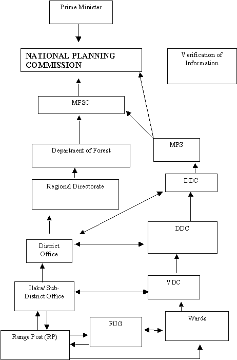
The department of forests has three main divisions working under the overall supervision of the director general. The department mainly takes care of field implementation of development programs. District forest offices are established in 74 districts out of total 75 in the country. These offices are the focal point to implement forestry development activities through out the country. Many bilateral projects are supporting forestry activities in different districts. The planning and monitoring division of the department coordinates the annual planning process. The process of dissemination of information is illustrated in figure 1.
District forest offices, after the completion of the fiscal year, report the progress of implemented activities to respective divisions in the department: each division holds this information separately. The planning and monitoring division at the end of each fiscal year compiles necessary information for making composite annual report to forward to the ministry of forest and soil conservation and national planning commission.
Almost all the donor-funded projects concentrate on sustainable management of community forests. Bilateral projects associated with forestry sector include:
Natural Resource Management Sector Assistance Program (NARMSAP), Community Forestry Field Implementation Component (CFFIC). The program of this component is being implemented in the 38 districts of the hills of Nepal, funded by DANIDA.
Hill Leasehold Forestry and Forage Project (HLFFP). This project is implemented in 10 districts of central and western development region. The project is funded by International Fund for Agriculture Development (IFAD) and technical cooperation from FAO.
Nepal Australia Community Resource Management Project (NARCMP). Funded by the Australian government and implemented in the two districts of central Nepal.
Nepal UK Community Forestry Project (NUKCFP). Operational in 7 hill districts, 4 in eastern hills and three in western hills funded by the Department of International Development (DFID), UK.
Nepal Swiss community Forestry Project (NSCFP). Covers three hill districts in the central and eastern hills of Nepal. This project is supported by Swiss Development Cooperation (SDC).
Environment and Forest Enterprises Activity (EFEA). Covers eight districts in western and Far-Western development region of the country. This project includes three districts of Terai, one district of Inner Terai, and remaining four districts in Hill. This project is being supported by USAID.
Churia Community Forestry Development Project (ChCFP). Implemented in three districts which includes two Terai. This project is operating in the financial support of GTZ.
Community and private forestry component (cfpc) and tree improvement and silviculture component (tisc) are special programs funded by dannida under the narmsap. The area for cpfc is as for cffic. The tisc command area is the entire country.
Monitoring
FIGURE 1. INFORMATION FLOW MECHANISMS AND VERIFICATION OF INFORMATION
The existing Management Information System (MIS) in the Department of Forest was started during 1990 in the previous phase of the present day Community Forestry Field Implement Component (CFFIC), then World Bank funded Hill Community Forestry Development Project (July 1989 - June 1999).
The British government has been funding forestry sector projects for a long time. The British project, Nepal UK Community Forestry Project (NUCKFP), has its own model of data capture and retrieval. A forest user group (FUG) database has been developed in Koshi hill area as a central information bank. The same kind of database exists for Dhoulagiri Hills area. Lately, these projects have become pioneers in introducing photo maps, rectified aerial photographs, in community forestry planning and decision making processes.
LIST OF INSTITUTIONS INVOLVED IN DATA MANAGEMENT
The Tree Improvement and Silviculture Component (TISC) is developing Iso-Potential Vegetation Maps for the whole country. These maps may be used for various purposes in natural resource management and for effective planning and monitoring process from national to local levels. Other projects also collect attribute and spatial data and analyze the data for planning and monitoring purpose. These data are much related to the community forestry development processes. The mechanism of data update is annual. In addition to the bilateral or multilateral projects, other organizations involved in data management are:
Department of Forest Research and Survey
Department of National Parks and Wildlife Conservation
Survey Department
Department of Soil Conservation and Watershed Management
National Planning Commission Secretariat, Participatory District Development Program.
Central Bureau of Statistics (CBS)
International Center for Integrated Mountain Development (ICIMOD)
Tribhuvan University, Geography Department
The King Mahendra Trust for Nature Conservation
Katmandu Metropolitan City Office
In 1990, ICIMOD established Mountain Environment and Natural Resource Information Service (MENRIS) as a resource center of Hindukush Himalayan Region for the study and application of GIS technology. MENRIS/ICIMOD has built up a national level database integrating both spatial and non-spatial data. The source map is 1: 250 000 map of Nepal. Major themes are: National boundary, district boundary, road, river network, settlement and spot height points, elevation contours, national park and reserves system and vegetation types. Recently, MENRIS has established a core Katmandu Valley GIS database based on 1:25 000 topographic maps and remote sensing images. The database is available in an interactive CD-ROM to increase information sharing.
Central Bureau of Statistics (CBS) under the National Planning Commission (NPC) Secretariat is the focal point for collecting socioeconomic and demographic data. Each year the Bureau updates the data either by projection or by primary data collection and publishes a Yearbook. Nepal has a long history of census taking. The first recorded population census of Nepal was taken in 1911. This has been continued in an interval every 10 years. The first scientific census taking with modern approach was started since 1952/54.
MAJOR ISSUES, WEAKNESS AND GAPS
Some issues related to the data management in Nepal, particularly in the forestry sector are identified as below:
The topographic maps prepared in different time in the past are different in terms of their scale, graticule and spatial details.
Thematic maps prepared in 1984 using the aerial photographs of 1978/79 are not updated yet.
Objectives and strategies of forest management have changed over the years. Therefore, forest inventories made at different periods are not comparable with each other.
The management units used by the Master Plan and National Forest Inventory (NFI, 1999) is different. The Master plan has used physiographic zones, assessable and non-assessable forest area, whilst the NFI has used Hills and Terai zones as well as reachable and non-reachable forest areas.
Planning and monitoring is becoming merely a ritual process. It does not include information that could be useful for decision making. Therefore, the need of data collection, storage and easy retrieval is not felt widely among the professionals.
Although, the supply of hardware and software has increased in many organizations, the commitment of organization and professionals is seriously lacking.
data collection strategy, IMPROVEMENT AND analysis
Organizations have different methods of acquiring, storing, processing, analyzing and viewing data. Exchanging, sharing and integrating data from different sources has become increasingly important for efficient utilization. However, at present, handling of information among different institutions is neither efficient nor cost-effective. Data are generally unavailable or poorly maintained, outdated, or incorrect. Maps are in different scales and have different coordinate systems complicating overlays and integration. Spatial information is not defined in a consistent manner and, therefore, of low standard. Data are not archived in such a way that they are available for use in later stages.
Assessment of the need of different types of data was made during the regional planning workshop in the winter of 2000. A data gap was identified and the participating districts agreed to make up the gap with appropriate data. Another important conclusion made out of this discussion was the lack of coordinated approach of information dissemination among development partners. One of the major tasks of the central government is to evaluate whether or not the project approach in that sector is contributing to the overall national development goals. It becomes only possible when the isolated efforts of a single project and program is evaluated in the light of broader national goals.
Realizing the importance of integrated data management for the forestry sector, a central databank, Integrated National Forest Database (INFDB) system is being established in the Forest Department. Data storage will be done using two basic methods. Spatial data will be stored in GIS database. Non-spatial data will be stored in digital form in Relational Database Management Systems (RDMS). Such non-spatial data comprise of biophysical and socio-economic aspects.
To make data updating easy, selective permission would be provided for updating and retrieval of data up to regional levels. The updating mechanism will gradually be expanded to district levels. The department has prepared an action plan for these activities. The plan is supposed to be implemented by the department of forests. Since many development activities will only be completed at the end of each fiscal year, bulk of data will be collected at this time. Consequently, much of the data update will take place from the beginning of the new fiscal year, generally after 2nd week of july every year.
Socioeconomic data necessary for forestry purpose, like census and economic surveys, are periodically collected by the Central Bureau of Statistics (CBS). In Nepal, CBS is an apex body that takes care of collection, storage, update and dissemination of such data. Mechanism will be established to acquire such data in digital form and update the Integrated National Forest Database (INFDB) periodically.
Line Departments like Department of Soil Conservation and Watershed Management (DSWM), Department of National Parks and Wildlife Conservation (DNPWC), and Department of Forest Research and Survey (DFRS) are working in close cooperation. The primary user of DFRS output is the Department of Forest. This department conducts National Forest Inventory and related forest activities.
Similarly, a network among the regional countries will be made in order to facilitate data sharing. The publication of data will also be made in the network. Department of Forest, Nepal, is in the process of maintain appropriate web site for this activity. This will be very useful to international organizations, researches and other interested stakeholders in the forestry sector of Nepal. All geo-referenced data will be prepared, processed and stored in a GIS environment. Department of Forests is also working in the establishment of a functional GIS laboratory as soon as possible.
Since manpower development is the crucial step, training and refresher courses will be organized for the concerned officials in the Department and Regional Offices. People will be sent for training organized by the Department of Geography, Tribhuvan University and outside periodically. The Planning and Monitoring Division in the Forest Department will coordinate all these activities to be expedited in stipulated time.
The Government should formulate the policy of information automatization in all of its agencies. As envisaged in the ninth Five Year Development Plan of the country (1998- 2002) Planning and Monitoring Section of every Ministry and the Departments of the central government should be in the node of network. This will facilitate information sharing and bring efficiency in program monitoring.
CONCLUSION
The Department of Forests is slowly automating its information storage and retrieval activities. The department is advocating the procurement of PC units for district forest offices to the respective donor agencies and requesting they assist in supporting the district office until the office becomes able to handle the system independently. The department itself is routinely sending staff to software application training. The donors are also supporting in this endeavor of the department. Some donor-funded projects have already introduced spatial analysis mechanism in district level planning process. They are slowly introducing aerial photographs for various activities including forest boundary delineation, user segregation and area mapping. In future, relevant spatial and attribute data for planning will be made available through an well-accepted process in an information management system.
![]()
![]()
![]()