


Three major forest/woodland types are distinguished in Eritrea: highland forests, Acacia woodlands and riverine forests. Originally the highland forests of Juniperus procera and Olea africana would have extended over much of the plateaux, but have been largely destroyed or degraded; only remnants now survive. On the lowlands and lower escarpments, Acacia woodlands occupy about a quarter of the surface of the country. Riverine forests fringe river systems of the Gash/ Mereb, Setit and Barka in the Lowlands, where Doum palm is an important constituent. These forests are under the greatest threat as they occupy fertile, well-watered and level sites – suited to development for commercial agriculture. However, they are also vital to the lives of the local population. On the coastal plains tree cover becomes increasingly sparse towards the sea. In places mangroves border the coast, the main species being Avicennia marina.
Natural forest cover has been classified according to six major vegetation types following international methodology.
Highland forest, composed of a mixture of coniferous species (Juniper) and broad- leafed species (African olive and associated species)
Mixed woodlands of Acacia and associated species, occurring mainly in the southern part of the western lowlands, but also in restricted areas elsewhere in the country;
Bush or shrub vegetation, which is the dominant cover in Eritrea;
Grasslands and wooded grasslands, which occur in many parts of the country;
Riverine forest, composed essentially of Doum palm, which is common in the Western Lowlands and is frequent in the Eastern Lowlands; and
Mangrove occurring in many places along the coast and concentrated mainly around Assab and between Tio and Massawa.
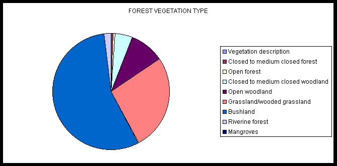
The natural vegetation of the country constitutes 0.8% highland forest. Forest and woodlands, including riverine forest and mangroves cover 13.5% of the total area. The category "bush" is the dominant vegetation in Eritrea covering 63% of the total area. The riverine forests and mangroves play important ecological and economic roles for rural communities, and occupy 1.5% and less than 0.1%, respectively.
(Source: Interpretation of Landsat TM by FAO project TCP/ERI/12 (July, 1997)).
The most recent national vegetation cover data is presented in Table 1.
Table 1: Forest/ Woodland Types and Distribution
|
Forest Type |
Km2 |
Share of Total Area |
|
Forest Closed to medium forest Open forest |
591 410 |
0.8% |
|
Woodland Closed to medium closed woodland Open woodland |
4533 9541 |
11.3% |
|
Bushland Grassland/Wooded Grassland Bushland |
25,577 53,824 |
63.8% |
|
Riparian forest Riverine forest Mangroves |
1,865 64 |
1.6% |
 Source: FAO, 1997
In the above table, it shows that Eritrea has an important vegetation cover composed of woodlands riverine forests and mangroves, in addition to the Juniper-Olea forest. The total area of these formations constitutes 13.7 % of the total landmass of the country.
Prior to liberation (before 1991), though few accurate records were maintained, tree planting was concentrated within 6 major catchments (namely, Anseba, Nefhi, Damas, Mereb, Ferendayt and Leghede) as part of a soil and water conservation strategy, based on Food- for-Work. In this way over 10,000 ha of plantation were planted, mainly consisting of Eucalyptus cladocalyx, but also E. globulus, E.camaldulensis, Acacia saligna, A.decurrens, A. mearnsii, etc. Such work was nearly always combined with physical terracing operations. Due to the lack of subsequent maintenance, few of these plantations remain.
In the years leading up to liberation, tree planting by farmers appears rarely to have taken place. Tree planting for amenity by municipalities has obviously taken place in the past, to good effect, but due to the uncertainties prevailing over latter years, existing trees have been damaged, or have died, and there has been little management or replacement.
This tree planting was based on approximately 31 nurseries, located principally within territory held by the Ethiopian Government.
Following liberation (1991 - 1998) about 69.9 million seedlings have been planted and 147,580 ha of an area closed for natural regeneration. Details of major activities are tabulated below:
Table 2: Achievements of Afforestation Programme (1991 – 1998)
|
No |
Activity |
Unit |
Achievements |
|
1 2 3 4 5 6 7 8 9 10 11 |
Hillside terrace con. Check dam con. Micro basin con. Seed collection Seedling- production Planting & Replanting Road-construction Spot weeding & cultivation Nursery establishment Closure area Peasant training |
ha km No kg No " km ha No ha No |
18,838 2,169 1,084,164 21,654 84,006,154 69,938,448 261 1,273 47 147,580 4,440 |
The survival rate of the planted seedlings, is about 30 - 40% in the Lowlands and
60 - 70% in the Highlands.
Since Liberation, there has been an upsurge of interest on tree planting by individuals, communities and organisations with large numbers of seedlings collected from nurseries, free of charge. Since 1994, the Eritrean students have been participating in afforestation and soil conservation campaign during summer vacation, in the whole country, which is organised by the Ministry of Education and the Ministry of Agriculture. Since then, about 19,000 students have participated every year and planted about 5.8 million tree seedlings.
The main afforestation programme is directed at soil and water conservation and fuelwood production. There has been a major and commendable commitment by the Eritrean Government to continue a programme that evolved under the Ethiopian regime as an instrument of international food assistance. The old model of Food For Work (FFW) or Cash For Work (CFW) was successful to the extent that it engaged community participation in the short term. But, it has no mechanism to engage them beyond that because they are unable to identify with the objectives and outputs, hence the government is assessing the cost-effectiveness of continued investment along this lines.
