![]()
![]()
![]()
H. Belvèze and K. Erzini*
Institut Scientifique Des Peshes Maritimes (ISPM)
Casablanca, Morocco
* Present address: Graduate School of Oceanography
University of Rhode Island
Narragansett, Rhode Island
USA
Resumen
La sardina es la especie dominante en la pesquería nerítica del Noroeste de Africa. Se han identificado tres unidades de stock, las que probablemente tienen algún grado de mezcla, y hay tres tipos de pesquerías que se han desarrollado después de la última guerra mundial.
La pesquería de marruecos es la que se encuentra más hacia el norte y es la que se encuentra expuesta a las variaciones más amplias en la disponibilidad de los recursos, lo que afecta la explotación por parte de los barcos artesanales con redes de cerco que tienen un reducido radio de acción. La disponibilidad está influenciada por las variaciones de la intensidad de los afloramientos, los que en verano provocan una migración trófica de la sardina del sur hacia el norte.
Al haber revisado la información disponible sobre el sistema de afloramientos en la corriente de Canarias y sus efectos sobre la productividad biólogica, los autores ponen en evidencia la influencia de los factores climáticos como las lluvias y la intensidad de los vientos alisios sobre la producción. Las capturas más importantes se obtienen en años de fuerte sequía, los que parecen ocurrir en ciclos de siete a ocho años. El análisis de la velocidad del viento en el centro del área donde se desarrollan las pesquerías muestra una disminución progresiva en los últimos veinte años, la que se hace más significativa desde 1975; esto ha afectado el volumen y composición de las capturas. La variabilidad del viento parece tener tanta importancia como su velocidad promedio en el proceso de productividad biológica de la región.
La disminución de la captura por unidad de esfuerzo de la flota de marruecos no es proporcional con la evolución de la abundancia de los stocks. Si la tendencia a la disminución de los vientos alisios continúa en el futuro, la disponibilidad de sardina en las zonas de pesca tradicionales continuará a disminuir y el patrón de la explotación de este recurso tendrá que ser completamente modificado para permitir una mayor utilización de la caballa y para tomar en cuenta el desplazamiento de la pesquería de sardina hacia el sur.
Los autores también han analizado las variaciones en la biomasa y las capturas observadas al sur del área en las otras pesquerías, en función a los datos sobre la intensidad de los afloramientos disponibles. No se puede explicar una relación aparente entre las capturas en la pesquería central y la intensidad promedio del afloramiento durante los últimos tres años en base a un incremento del tamaño de la población, ya que no se ha podido demostrar ninguna relación, entre el reclutamiento y el afloramiento. Por el contrario, en la pesquería del sur, que es la más reciente, la biomasa y las capturas han aumentado considerablemente a continuación de un aumento del afloramiento, y luego han disminuido cuando la fuerza de afloramiento volvió al nivel promedio de los años precedentes. La abundancia de este stock está estrechamente correlacionado con la intensidad del desove en los dos o tres últimos años.
INTRODUCTION
GEOGRAPHICAL SITUATION WITH RESPECT TO STOCKS AND DESCRIPTION OF FISHERIES
Geographical Situation
The sardine (Sardina pilchardus Walbaum) is found in west African Atlantic coastal waters from the Strait of Gibraltar (36°N) to Cape Blanc in Mauritania (21°N), where it is the principal small pelagic resource (Figure 1).
Surveys of exploration and acoustic evaluation undertaken between 1973 and 1982 have shown that the distribution of the sardine is not homogeneous (Villegas and Goodlad 1974; Lamboeuf 1974, 1977; Johannesson et al., 1975; Bazigos et al., 1980; Lamboeuf et al., 1981; Lamboeuf et al., 1982).
This heterogeneity has given rise to different fisheries which have been described several times by different authors (Belvèze 1972; Krzeptowski 1975, 1978; Bravo de Laguna et al., 1976; Barkova 1976; Belvèze and Bravo de Laguna, 1980).
There exist a number of studies on biometric and meristic characteristics (number of vertebrae, number of branchiospines), of growth curves and of biochemical composition (protein electrophoresis of the eye lens) (Furnestin 1950, 1955; Cadenat and Moal, 1955; Moal 1957; Rodriguez-Roda 1958; Andreu 1969; Belvèze 1971; Maigret 1974; Krzeptowski 1975; Bravo de Laguna et al., 1976; Barkova and Domanevsky, 1976; Belvèze and Rami, 1978; Biaz 1978; Barkova 1976; Fernandez et al., 1978; Freon and Stéquert, 1979).
Studies of these areas and periods of reproduction have also been published (Furnestin and Furnestin, 1959; 1970; Barkova 1976; Rubies and Palomera, 1977; Sedletskaya 1973).
Although at times contradictory, these observations have lead the Ad hoc Working Group on the Sardine of the Committee for East Central Atlantic Fisheries (CECAF) to identify three population units from north to south. However, it is probable that there is a certain amount of mixing between these stocks at their borders during the seasonal migrations, as pointed out by Bravo de Laguna et al. (1976) and Fernandez et al. (1978).
These population units are situated between 36°N and 33°30'N, 32°30'N and 27°N, and 26°N and 21°N (Figure 2). Their relative importance varies with time. The northernmost population is always the smallest.
Description of Fisheries
The sardine fishery developed progressively from the north to the south during the last forty years. The start of the exploitation goes back to the 1930's, taking place from existing ports: El Jadida, Casablanca, Mohammedia and Larache, and concerned only the small northern stock.
After World War II, fishing started between 32°30'N and 30°N from the ports of Safi, Essaouira and Agadir, which now account for about 90% of the Moroccan sardine catch. The catch is taken by a fleet of 230 to 250 artisanal, wooden seiners of small size. Average gross tonnage increases regularly, passing from 35 tons in 1970 to 52 tons in 1981. The fleet is not homogeneous, with sizes varying from 15 to 120 tons.
The sardine boats put their catches into the holds without any means of preservation on board. Thus, the extent of the fishing area is limited by the rate of decomposition of the fish. The time spent at sea does not exceed twelve hours, which corresponds to a maximum distance from the home port of approximately 40 nautical miles. This limitation of fishing area does not allow the fishermen to follow the movements of the sardines and therefore, this fishery is gravely affected by the availability of fish within the zone of action. This results in important fluctuations in landings from one season to another and from one year to the next. This fishery, which exploits only the northern part of the population living between 32°30'N and 27°N, has been named fishery A by the Working Group on the Sardine of CECAF, and we will use this terminology in this paper.
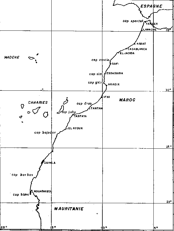
Figure No 1: Geographical situation of the Northwest African coast and the names of localities or capes mentioned in the text.
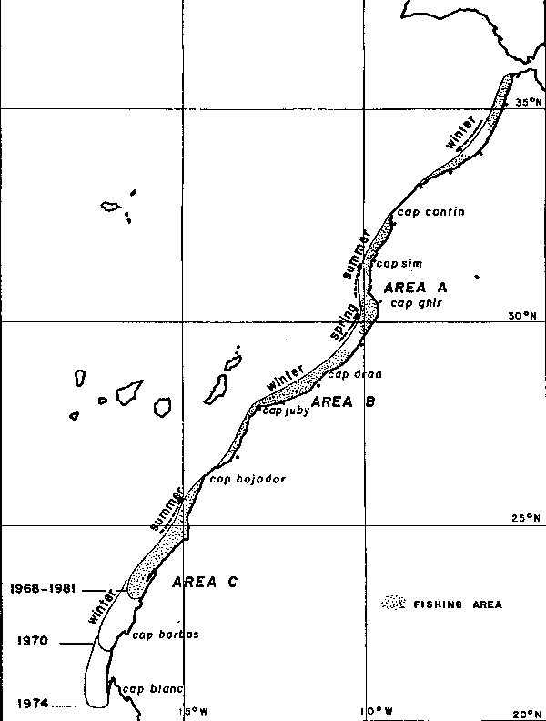
Figure No 2: Areas populated by the sardine, fishing areas and digram of seasonal migrations along the Northwest African coast.
The by-catch of the seiners is composed of mackerel (Scomber colias), horse mackerel (Trachurus trachurus), anchovy (Engraulis encrasicolus) and more episodically, of trumpet fish (Macrorhamphosus sp.). However, the sardine is largely the predominant species.
Since 1965, a second fishery has developed for the southern part of the stock, between 29°N and 27°N. The boats are artisanal seiners based in the Canary Islands ports, about 100 nautical miles from the African coast. Numbering about 40, their size has been increasing for several years. Mean gross tonnage has grown from 130 tons in 1976 to 190 tons in 1980. Equipped with refrigeration or freezing systems, they can stay at sea until their holds are full. Their sphere of action and their mobility allow them to follow the movements of the sardine and to exploit year-round the zones of greatest concentrations.
This fishery has been named Fishery B by the CECAF Working Group on the Sardine.
Other boats have exploited or are still exploiting fishery B, either from Moroccan ports or from distant ports, but their catches are very small compared to the Canary Islands based boats.
There is little information on the accessory catches, but it appears that the sardine is the dominant species.
More recently, a fishery has developed based on the sardine to the south of the 26th parallel. Fishing is carried out by large pelagic trawlers, semi-pelagic trawlers and seiners associated with factory ships. Starting in 1969, this fishery has grown rapidly. The development of this fishery appears to be linked to a rapid increase in the sardine stock, followed by a geographical movement to the south after several massive spawnings, and intensified productivity in this region (Holzlohner 1975; Krzeptowski 1975, 1978; Domanevsky and Barkova, 1981).
Catch statistics are available for fisheries A, B and C (Statistical Bulletins of the CECAF, Reports of the Working Group on the Sardine of the CECAF). Catches for each fishing zone from 1965 to 1981 are presented in Figure 3.
Catches from zone A have varied around an average of 160,000 tons. Peak catches have been made in 1966, 1973 and 1983, with 1977 and 1978 having the lowest catches.
In zone B, catches increased regularly from 1965 to 1975, stabilized at around 120,000 tons from 1975 to 1978, and then diminished to 90,000 tons.
Zone C has experienced an extraordinary growth in catches, with an increase from 90,000 tons to 650,000 tons (1976) in six years, followed by a drop to 200,000 tons in three years.
GENERAL HYDROCLIMATIC CHARACTERISTICS OF THE AREA AND REVIEW OF LITERATURE ON THE CANARY CURRENT UPWELLING SYSTEM
General Climatology
The African Atlantic coast between the Strait of Gibraltar (36°N) and Senegal (15°N) is backed by a region which is, to a large extent, desert or sub-desert in character. In the middle of this area is the subtropical high pressure belt which is made up of two different units:
-- The Atlantic anticyclone (anticyclone of the Azores) which is variable, in absolute value and in geographical position. To a large extent, it governs the Moroccan climate.
-- The high altitude Saharan anticyclone, which is much more stable and which gives rise to a thermal depression.
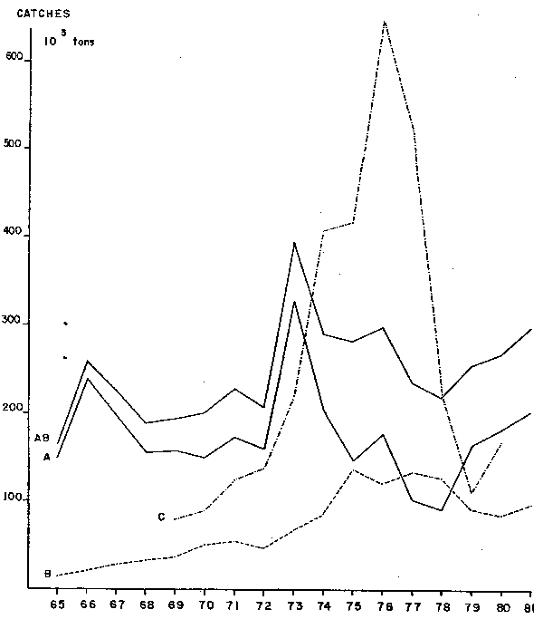
Figure No 3: Catch of sadines in the different fisheries of the Northwest African coast from 1965 to 1981, in thousands of tons.
Between these two units, there is a quasi-stationary boundary between air of polar origin which circles the Atlantic anticyclone on the eastern side and tropical air from the southwest, which rises over the Saharan anticyclone. This boundary is sometimes called the trade wind front (Calvet and Le Goff, 1977).
Schematically, we can identify two seasonal situations;
-- The summer situation (Figure 4): The Atlantic anticyclone, centered in the neighbourhood of the Azores (38°N latitude) is strong (1035mb), and drives the oceanic perturbations to northern Europe. A system of north to northeasterly winds (trade winds) is set up along the coast from 36°N to 20°N.
-- The winter situation (Figure 5): The anticyclone has descended to the west of the Canary Islands (25°N latitude) and has weakened (1025 mb). This permits the passage of a depression extending from Greenland to North Africa. This gives rise to west and southwesterly winds, which bring rain to Morocco north of 28°- 30°N latitude. The trade winds are thus to the south of the Canary Islands, affecting the coastal region between 26°N and 15°N.
The result is a seasonal balancing of the trade winds, which originate off Gibraltar in the summer and more to the south in winter (LeFloch 1974). The position and strength of the anticyclone of the Azores governs the wind system along the northwest African coast as well as the rainfall of the northern half of Morocco.
General Hydrology
From the Strait of Gibraltar (36°N) to Cape Blanc in Mauritania (21°N, the African coast is oriented more or less from northeast to southwest, with a succession of concave and convex parts determining capes (Figure 1). The trade winds, blowing from north/north-east are thus approximately parallel to the coast. The general sea surface circulation in this region is linked to the Canary Current. This northeast to southwest movement transports relatively cold waters along the northwest African coast (LeFloch 1974). The combination of this movement of water towards the south and the effects of the trade winds cause the upwelling of deep waters towards the surface. The upwelling varies in time and space as a function of bottom and coastal topography and the seasonal character of the trade winds. The origin of the upwelled water is at an average depth of 200 m. The temperature may be less than 16°C and the salinity, lower than that of oceanic surface waters, may reach a minimum of 35.7%, especially in the Cape Blanc area, where the North Atlantic waters of the Canary Current mix with the waters of lesser salinity from the south (Fraga 1974).
The emergence of these nutrient-rich waters in the euphotic zone results in the increased primary and secondary production characteristic of upwelling regions.
The existence, nature and mechanisms of these phenomena along the northwest African coast have been studied by many scientists in the past forty years.
Brief Review of Studies on the Canary Current Upwelling
The Canary Current was described by studies of Prince Albert I of Monaco at the turn of the 19th century. Rouch (1931, 1948) explained the relatively low temperature of the current not only by the northern origin of the waters but also by the upward movement of deeper water taking place along the coast. Roux (1937) also attempted to describe the movement of the Atlantic water off Morocco by the theory of transgressions proposed by LeDanois in 1921.
It was the work of J. Furnestin from 1947 to 1953 which was the first to describe in detail the hydrology between the Strait of Gibraltar (36°N) and Cape Juby (28°N), and which gave evidence of the seasonal and regional character of the upwelling (Furnestin 1950 and 1959). Seven-year temperature averages allowed Furnestin (1959) to make trimesterly isotherm charts which show the principal characteristics of the system in the area of study. The upwelling, feeble or non-existent in winter, develops in spring, grows stronger in the summer and declines in fall in the coastal sectors between Safi and Cape Ghir, and between Ifni and Cape Juby. A small upwelling is found in the summer at the opening of the Strait of Gibraltar. Between these areas of active upwelling, the offshore waters, warmer and of higher salinity, may reach the coast, covering over the upwelled water and creating a well defined thermocline.
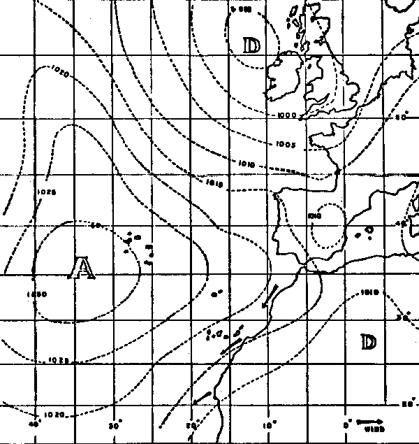
Figure No 4: Typical summer climatic conditions bringing about Trade Winds on the Moroccan coast.
Figure No 5: Typical winter climatic conditions bringing about winds from the southwest and rainfall on the Moroccan coast.
At the Symposium on the Living Resources of the Continental Shelf from the Strait of Gibraltar to Cape Vert, organized by the International Council for the Exploration of the Sea in 1968 in Tenerife, Allain (1970a) presented a synthesis of studies on the hydrology of the northwest African coastal area. At that time, there was little data concerning the region to the south of Cape Juby. Nevertheless, the cruises of the "Meteor" in 1925 and 1927 (West 1935; Bohnecke 1936; Defant 1936) and of the "Discovery II" (Worthington 1958) had already shown the existence of upwelling from mid-depths.
Several papers presented in the symposium gave evidence of various upwellings along the Northwest African coast between Cape Juby and Cape Vert. Jones and Folkard (1970) analysed the data from the cruises of the R.V. "Clione" (Summer, 1965), of H.M.S. "Hecate" (Spring, 1966) and of H.M.S. "Hydra" (Fall, 1967). They showed the existence of large areas of the Northwest African continental shelf where the surface waters are enriched in nutrients by a process of upwelling. Furthermore, they showed that the upwelling to the north of Cape Blanc (21°N) is not confined to the summer, and can also develop in other seasons. A good correlation was found between the wind system and the state of upwelling. Fedoseev (1970) found that it is in winter and in spring that the geostrophic circulation at the surface is the strongest, corresponding to a strengthening of the Trade Winds at this time between Cape Juby and Cape Blanc. Mascareno and Molina (1970) found an upwelling below Cape Juby to be more important in September 1966 than in March 1967. Wozniak (1970) studied the upwelling at Cape Blanc in June and July, 1963. In June, the upwelled waters originated from the Canary Current. In the latter month, stronger upwelling gave rise to warmer, more nutrient-rich water of tropical origin. These observations were confirmed for the months of June and July, 1967 by Wiktor and Chlapowski (1970) and for December 1962 by Allain (1970b). Mascareno (1970) showed the existence of an upwelling at Cape Leven (24°35'N) during the month of June 1968, when the water drawn from the Canary Current was progressively overlapped by a layer which was warmer and of greater salinity.
Following the symposium, which demonstrated the lack of in-depth studies concerning the phenomenon of upwelling and its effect on the biological productivity of the Northwest African coastal waters, an international research program was set up by the C.O.I. in 1969. The CINECA (Cooperative Investigations of the Northern Part of the Eastern Central Atlantic) program, carried out by the I.C.E.S., set up important means and a considerable research framework. The results were analyzed at several conferences: at Barcelona (March 1970), Marseille (May 1973), Kiel (August 1975); and were discussed at a symposium organized by the I.C.E.S. at Las Palmas in April 1978 (The Canary Current: Studies of an Upwelling System).
A number of important publications enables the identification of the general features of the upwelling along the Northwest African coast.
The overall distribution of the surface isotherms shows that the phenomenon takes place mainly between 12°N and 33°N (Schemainda et al., 1975; Wooster et al., 1976; Smed 1982). This large area is subdivided into three areas where the upwelling is influenced by the local meteorological and atmospheric conditions to which they are subjected.
To the north of 25°N, upwelling occurs mainly in summer. To the south of 20°N, it takes place in winter and spring. Between 20°N and 25°N, upwelling exists year round, with greater activity in the spring when the region of upwelling shifts to the north, and in fall, when it shifts towards the south (Speth and Detlefsen, 1982).
These three areas differ not only in their seasonal character, but also in the nature of the water which is upwelled. The two principal types of water involved in upwelling are the North Atlantic Central Water (NACW), which makes up the major part of the Canary Current, and the South Atlantic Central Water (SACW), which comes from the south. Fraga (1973, 1974), Fraga and Maniquez (1974), Tomczak (1978, 1982), Manriquez and Fraga (1982), Fiuza and Halpern (1982), and Barton (1982) all agree in that the mixing front of these two types of water is in the region of Cape Blanc (21°N). The existence of a subsurface counter current taking SACW from north of Cape Blanc to about 25°N confirms the complex origin of the upwelled waters between 21°N and 25°N (Hughes and Barton, 1974; Mittelstaedt 1982). The upwelled water is made up of a mixture of NACW and SACW, modified at the surface by the original surface water (Tomczak 1977, 1978, 1982).
The SACW are richer in nutrient salts than NACW. This results in a gradient from south to north.
Minas et al (1982) presented a synthesis of studies on nutrient salts and primary production in this region at the Las Palmas symposium in 1978. We will refer to this work for a brief summary of the situation.
The north-south concentration gradient of mineral salts is not expressed by a similar gradient of primary production. Higher production rates take place to the south of Cape Blanc in the winter only. From Cape Blanc to Cape Barbas, the enrichment of upwelled NACW by the nutrient-rich SACW brought by the counter current, and the persistence of a year-round upwelling results in the highest annual rates of production in the region. Between Cape Barbas and Cape Bojador, the extension and relative shallowness of the continental shelf, as well as its configuration, modify the upwelling by the persistence of a "cushion" of cold water, a well-developed thermocline, and thermal boundary. In summer, the upwelling at Cape Bojador, the upwelled water consists primarily of NACW. Despite being less rich in nutrients, primary production appears to be as important as in the south, due to highly efficient nutrient recycling.
We will examine the region between Safi and El Ayoun in greater detail because it is here that the principal sardine population, exploited by Moroccan boats, is found.
Except for the work of Furnestin (1959), the only knowledge on the upwelling and productivity of this region comes from the cruises of "J. Charcot" (CINECA I to V), analyzed by Grall et al. (1974), LeFloch (1974), Groupe MEDIPROD. (1974), Minas et al. (1974), LeCorre and Treguer (1976), Thiriot (1976), Huber et al. (1977), Treguer and LeCorre (1979), and Grall et al., (1982).
The region is divided into two distinct zones: the northern zone between Cape Sim and Cape Ghir, and the southern zone between Ifni and Cape Juby. The two zones are sites of upwelling where the source is from 150 m depth in winter, and 250 m in summer (LeFloch 1974; Grall et al., 1974). They are separated by warmer water in the Bay of Agadir, which is considered by Treguer and LeCorre (1979) to be older, rewarmed upwelled water.
In the northern part, the upwelling source is situated between Cape Sim and Cape Tafelney. The bottom topography allows a southwest extension from this source of a tongue of cold water, rich in nutrients. Between this tongue and the coast, a counter current transports warmer water from the Bay of Agadir to the north of Cape Ghir. This upwelling source is affected considerably by the local wind system. The local winds are stronger at the end of the day (30 knots), and weaker at the end of the night (10 knots) (Grall et al., 1982). This strengthening of the Trade Winds at the end of the day is due to the formation, in summer afternoons, of a small thermal depression in the Agadir plain (Richbé, pers. comm.). The effect of this pulsing phemomenon is important at the surface (cooling and increase in nutrient level). It is of little importance below 50 m where the upwelling is stable (LeSaos and Talarmin, 1976). Grall et al. (1982) have shown that there is a time lag of about three hours between the strengthening of the wind and its effects on the surface, and a time lag of about six hours between the weakening of the wind and the complete stratification of chlorophyll a. The highest rates of production (more than 3 g C/m2/d) take place as the weakening of the wind reduces mixing and when there is advection of warm coastal water. Strong winds (35 m/s) cause powerful upwelling at the surface but hinder primary production by creating complete vertical homogeneity through vigorous mixing. Turbidity associated with strong mixing may also limit photosynthesis. The rate of production increases as the force of the wind diminishes.
In the southern area, between Ifni and Cape Juby, the continental shelf is wider and has a gentler slope. The winds are more regular and not as strong, being intermediate between the maxima and the minima of the northern area (20 knots). The cold waters of the upwelling appear at the surface only from time to time. A cushion of cold water over the continental shelf has physical and chemical characteristics similar to that of water found at 200-300 m depth, but has greater nutrient concentrations. This cushion is the site of important nutrient recycling, as shown by LeCorre and Treguer (1976). Grall et al. (1974) identified three levels of production corresponding to this water column formation. The upper surface level is warm and is poor in chlorophyll and nutrients. The intermediate level has strong temperature and nutrient concentration gradients. High concentrations of chlorophyll are found in bands of approximately twelve meters thickness. The lower level, site of nutrient regeneration, is rich in nutrients, but poor in oxygen and chlorophyll pigments.
Nutrient regeneration is an important factor in the upwelling of this region. The recycling of nutrient salts explains the high levels of productivity even though the nutrient concentrations in the upwelled water (NACW) are inferior to those of the regions to the south (SACW or a mixture of both). A table comparing nutrient concentrations and productivity of coastal waters from different areas, (Minas et al., 1982 modified from LeCorre and Treguer, 1976), shows that rates of production between Cape Sim and Cape Ghir in summer are comparable to those found off Cape Blanc.
Codispoti et al. (1982) have compared the characteristics of the upwellings of Lower California (27°N), of Peru (15°S), and of Northwest Africa (21°30'N). They show important differences in the flow of mineral salts, their assimilation and their regeneration. The upwelled waters of the Atlantic are poorer in nutrients and richer in oxygen than those of the Pacific. The relations between local winds and upwelling are more evident for the Northwest African coast than for Peru, where inter-annual variations are more pronounced. Rates of nitrate assimilation are higher in the Peruvian upwelling, but denitrification and occasionally, the production of hydrogen sulfide, may take place. The more powerful winds of the Northwest African coast give rise to strong mixing and important turbidity which may limit photosynthetic activity. The nutrient regeneration cycle differs for Peru, where the continental shelf is narrower and is swept by a current flowing offshore. The winds are weaker, allowing better stratification of coastal waters.
There are few studies on the relations between the productivity of the upwelling area and its stocks of fish. The extension towards the south of the region inhabited by the sardines, was explained by a strengthening of the upwelling in this region since 1970 by Holzlohner (1975) and by Sedykh (1978). Nehring and Holzlohner (1982) have shown that between Cape Bojador and Cape Barbas, there is a relationship between the average concentration of chlorophyll a, the total volume of sardine schools, and the daily catches of a trawler.
MIGRATION OF THE SARDINES AND INDICES OF ABUNDANCE FOR THE REGION OF THE MOROCCAN FISHERY
Migrations
The three sardine populations found on the Northwest African coast carry out seasonal movements along the coast. Furnestin (1959) and Bravo de Laguna et al. (1976) proposed a diagram of migration in relation to hydrological features. Belvéze and Bravo de Laguna (1980) took the data of earlier authors, and, using the observations of Krzeptowski (1975) and of Barkova (1976) as well as distribution charts obtained from acoustic surveys, suggested an overall hypothesis for these migrations. Since no tagging has been carried out with any success, this hypothesis was based partly on the activity of the fishing fleets and on the results of acoustic surveys. The three populations carry out synchronous movements toward the south in winter and toward the north in summer (see Figure 2).
The small northern population extends from the Strait of Gibraltar to El Jadida in winter. In summer, it withdraws to the area between Larache and Tangier, where there is summer upwelling. The sardine fishery at Casablanca takes place mainly from the end of fall to spring. Conversely, the greatest activity in Tangier and Larache is during summer and fall.
In winter, the central population leaves fishing zone A (between Safi and Ifni) and concentrates in fishing zone B (between Ifni and El Ayoun), where the region of maximum reproduction is found. In spring, the population migrates partially to the north, and in summer, occupies all the area between Safi and El Ayoun (zone A + B). It is thus a spreading out of the population in summer and a aggregation in winter rather than an over-all migration of the stock. A certain portion of the stock may remain during winter between Safi and Agadir (zone A) and gives rise to a winter or spring fishery for boats based at these ports. The majority of the Moroccan catch takes place in summer and in fall, when the sardines coming from the south enter fishing zone A. To the south, in fishing zone B, acoustic surveys have shown that the sardine is abundantly present all year round between Ifni and El Ayoun. The fishing season of the boats based at the Canary Islands extends year round, but the best catches take place in the fall, when the sardines concentrate in zone B for spawning (Delgado and Fernandez, 1982).
The southern population carries out movements along the coast similar to those of the populations found north of it. The spacial-temporal distribution of Polish factory-trawlers, as presented by Wisokinski (1980), shows that in winter, the boats are concentrated between 22°N and 25°N. In spring, they shift northward, and in summer-fall, they are found between 24°N and 25°N. It is difficult to know whether the sardines which are found during the summer and fall in the region of El Ayoun (between 26°30'M and 28°N) belong to the northern part of the southern population or to the southern part of the central population. The hypothesis that a certain amount of mixing occurs between the two populations, proposed by Bravo de Laguna et al. (1976) and Fernandez et al. (1978), cannot be ignored. Acoustic surveys show a division in the distribution of sardines at the level of Cape Bojador in November (Marchal and Boely, 1977; Lamboeuf, pers. comm.) and February (Bencherifi, pers. comm.). There is also a division at the level of El Ayoun in July (Lamboeuf et al., 1981). However, there was no division between 30°N and 24°N in October (Lamboeuf, pers. comm.). The southern limit of this population has changed with time, as shown by Holzlohner (1975) and Domanevsky and Barkova (1981), without affecting the general form of the seasonal movements.
Thus, the three populations move in a more or less synchronous manner toward the north in summer and toward the south in winter. These movements have little effect on fisheries B and C, where the boats can follow the areas of greatest abundance. However, fishery A, where boats operate close to port and have a limited sphere of action, is strongly affected by the seasonal movements of the central sardine population.
Indices of Abundance for the Moroccan Fishing Zone (Zone A)
Fishing effort of Moroccan sardine boats based at Safi, Essaouira and Agadir, and operating in fishing zone A, was calculated by multiplying the gross tonnage of each boat by the number of daily trips carried out in a month (Belveze, 1974, 1981).
Annual fishing effort was obtained by calculating the sum of the monthly efforts, weighted by an index of average monthly relative abundance, in order to take into account the availability of the sardines and the length of the fishing season during the year. The effective fishing intensities were calculated as a function of the surfaces of the fishing area for each port and weighted by the fish densities according to the method of Beverton and Holt.
Data are available for the period from 1968 to 1981. The monthly CPUE averages during this period change seasonally, with a minimum in winter and a maximum in summer (Figure 6). The sardine is on the average more abundant in the fishing area of Agadir than in the area of Safi/Essaouira. These variations in CPUE through the year reflect the sardine movements considered earlier. From December to March, the small part of the stock which remains in Zone A during winter, is fished. Starting from April in Agadir and May in Safi/Essaouira, the CPUE increases due to the progressive arrival of sardines from the south. The maximum is reached in July at Agadir and in August in Safi/Essaouira. A second peak takes place in Agadir in October and is probably linked to the return movement towards the south from the region of Safi/Essaouira. Agadir is the first port in the path of migration and therefore, is closest to zone B, where the sardines concentrate in winter. Thus, Agadir has an advantage with respect to the other more northerly ports.
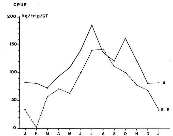
Figure No 6: Monthly means of catches per units effort in the fishing zones of Agadir and of Safi-Essaouira in kg per trip per of gross tonnage.
Table 1: Annual catch, effective fishing intensity and index of abundance for zone A for the period from 1968 to 1981.
| Year | Catch (tons) | Effective fishing intensity | Index of abundance |
|---|---|---|---|
| 1968 | 155 397 | 851.1 | 182.6 |
| 1969 | 157 168 | 821.8 | 191.2 |
| 1970 | 150 233 | 1020.7 | 147.2 |
| 1971 | 172 676 | 1256.3 | 137.4 |
| 1972 | 159 211 | 1284.6 | 123.9 |
| 1973 | 326 261 | 1400.1 | 233.0 |
| 1974 | 204 231 | 1278.1 | 159.8 |
| 1975 | 146 614 | 1246.9 | 117.6 |
| 1976 | 176 162 | 1410.5 | 124.9 |
| 1977 | 101 877 | 1291.0 | 78.9 |
| 1978 | 91 141 | 1270.3 | 71.7 |
| 1979 | 163 442 | 1543.4 | 105.9 |
| 1980 | 181 198 | 1660.8 | 109.1 |
| 1981 | 200 395 | 1578.1 | 127.0 |
Overall, the annual variations in abundance may be related to the seasonal character of the upwelling, as will be shown further on (Figure 10). The maximum abundance coincides with the period during the summer of greatest upwelling. One is thus tempted to link abundance and upwelling, and to explain the movements of the sardines by attraction to areas of high productivity. Since upwelling occurs in zone B as well, it is only part of the stock which migrates towards zone A in summer. Therefore, the availability of sardines in zone A depends not only on the size of the stock, but also on the rate of migration caused by the summer upwelling. Variations in the amount of upwelling may thus cause variations in the availability of sardines in zone A.
The catches, the effective fishing intensities and the annual indices of abundance for zone A from 1968 to 1981 can be seen in Table 1. Effective fishing intensity rose from 1968 to 1981, but was relatively stable from 1971 to 1978. Indices of abundance decreased from 1968 to 1978, despite a big increase in 1973. Since 1979, the trend has reversed, although fishing intensity is increasing. The rapid increase in 1973 of the index of abundance and its subsequent decrease while fishing intensity remained relatively stable, indicates that some factor other than fishing affected the abundance of sardines in this zone. One is tempted to explain the decrease in abundance in zone A by the development of a fishery in zone B (cf. Figure 2). It is likely that the growth in catches in zone B may be part of the cause for the sharp drop in abundance in zone A, that has taken place in the past ten years or so. This does not explain the big increase in 1973, nor the increase in the CPUE since 1978 while the fishing intensity increases in zone A. There are probably some fluctuations in abundance and in availability between zones A and B due to natural reasons (Figure 7).
To sum up, fisheries A and B exploit the same stock. Absolute variations in abundance affect the two fisheries, but fishery A (Moroccan) is additionally subjected to fluctuations in availability caused by seasonal migration of one part of the stock outside the sphere of activity of the boats.
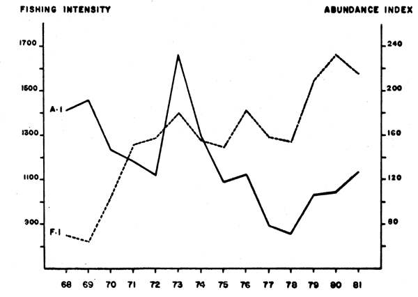
Fig. 7. Fishing intensity and indices of abudance for the whole of fishery A (Safi-Essaouira-Agadir) from 1968 to 1981.
RAINFALL AND CATCHES OF SMALL PELAGIC FISH IN MOROCCO SINCE 1936
Moroccan catches of sardines in zone A, landed in the ports of Safi, Essaouira and Agadir increased progressively from 1945 to 1965 with the development of the sardine fleet. Since 1965, catches have stabilized at an average of 160,000 tons a year, with some large variations. We have seen that due to the geographical position and the lack of cruising range of the Moroccan sardine fleet, the fishery is heavily dependent on the availability of the sardines within zone A. Belvèze (1974) has shown the coincidence of years of exceptionally high catches and years of big droughts at the coast from 1950- 1973 and put forward a hypothesis of a seven- to eight-year cycle.
Data
Rainfall. Rainfall is a parameter that has been recorded by coastal meteorological stations since 1936 at Agadir, and since 1955 at Safi and Essaouira. It is expressed in millimeters of water that has fallen for each year. For the period from 1955-1981, a comparison of rainfall at Safi-Essaouira and Agadir gave a positive correlation (r=0.71). A functional regression between the two series of data allows us to estimate rainfall at Safi-Essaouira for the period from 1936-1954. Thus, the total rainfall for this zone since 1936 can be calculated. The data is presented in Appendix 1.
Coastal rainfall of zone A (Figure 8) shows a succession of minima (exceptionally dry years), which occur with a certain regularity 1937-1944 (seven years); 1944-1950 (six years); 1950-1958 (eight years); 1958-1966 (eight years); 1966-1973 (seven years); 1973-1981 (eight years). Except for 1966, these years are followed by one or two dry years before the rainfall increases again.
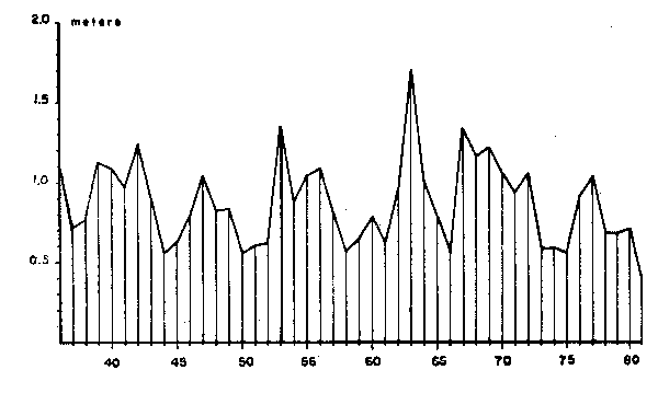
Fig. 8. Total coastal rainfall recorded at Safi-Essaouira-Agadir in m from 1936 to 1981.
Catches
Four main species are present in the catches of seiners. In order of importance, they are: the sardine (Sardina pilchardus) which is by far the dominant species; the mackerel (Scomber colias), with small amounts of the European species (Scomber scombrus) appearing when coastal waters are warm. The horse mackerel (Trachurus trachurus and Trachurus picturatus) of which the first, essentially neritic, makes up most of the catch, while the latter, more oceanic, appears only rarely in the landings. The anchovy (Engraulis enchrasicholus) is of little importance in the catches except in certain years such as 1970 and 1977.
In 1977 and 1978, sardine catches and catches per unit of effort were very low (Figures 3 and 7). At the same time, catches of mackerel and horse mackerel were exceptionally high, compensating for the lack of sardines and maintaining total landings of small pelagics at a level equivalent to other years. Annual catches for each species from 1960 to 1981 are given in Appendix II. The proportion of sardines in the total catch was greater than 90% until 1975. As there has not been a change either in fishing methods or in the area of exploitation of Moroccan seiners, the proportional decline in sardines is probably related to a change in relative availability of the different species.
Catches of small pelagics in zone A reflect those of the sardine, which is the dominant species, except for 1977 and 1978. The evolution of the catches is characterized by a succession of more or less stable stretches between maxima. These maxima were less pronounced before 1966, probably because individual capacity of the boats was still small and saturation would have limited large catches at times of great abundance. Since seining did not develop till after World War II, the catches of small pelagics from 1947 to 1981 in comparison with annual rainfall can be seen in Figure 9.
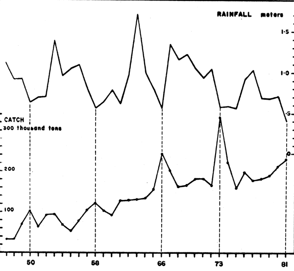
Fig. 9. Coastal rainfall (m) and catches of small coastal pelagics (thousands of tons) in zone A from 1947 to 1981.
Results
A graphical comparison of catches and rainfall from 1947 to 1981 shows the correspondence of exceptionally dry years with large catches. The hypothesis of a seven- to eight-year cycle put forth in 1974, seems to be confirmed by a dry year with increased catches in 1981. When several dry years follow, the important increase in catch takes place in the first year and not the following (cf. 1975). The years of very heavy rainfall, such as 1953, 1963 and 1967, do not result in any perceptible decrease in catch. It appears that rainfall has an effect on catches only in the case of extreme drought.
In order to measure the relative difference with respect to an average, the general average of the catches from 1947 to 1981 could not be used since catches have increased progressively with the development of the fishing fleet. The differences were calculated as percentages of annual values in comparison with a running average of nine corresponding years.
The results are given in Appendix III. A graphical representation shows the dispersion of the points with regard to the slope of the functional regression. The coefficient of correlation for the two series of annual values, ΔC% and Δ%R is -0.47. The correlation between rainfall and catch exists, but it is not a straight one (Figure 10).
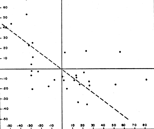
Fig. 10. Linear regression between deviations from mean rainfall Δ%R (as a percentage) and deviations of catches from a running 9-year avarage, Δ%C (as a percentage).
Discussion
Bakun and Parrish (1980) have emphasized the difficulty of testing a hypothesis when the same data were used to formulate the hypothesis. We will be content with the discussion of the empirical relation between rainfall and catches of small pelagics in zone A, without taking it as proof of the theory.
Rainfall may have an enriching action by the supply of mineral salts through river runoff. This supply is of greater importance when surface vegetation is poor and erosion is active, as is the case in Morocco. In this case, a period of abundant rainfall results in increases in primary production and then, stocks of fish. After a certain time lag, it translates into increases in catch, as is the case in the Moroccan fishery. Belvèze (1974) suggested that coastal rainfall does not act by itself, but is the reflection of a certain type of climatic condition in the area. The dry years are therefore, years when the Trade Winds remain for a long time, limiting rainfall to a brief winter period. There would then be an agreement between the dry years and the strengthening of upwelling in the zone. This strengthening would be the cause of greater availability of fish, primarily sardine, which would have earlier and more important migration from the south to zone A.
ANALYSIS OF THE CHANGES IN STRENGTH AND DIRECTION OF WINDS AT THE CENTER OF THE MOROCCAN FISHERY (ZONE A) AND THEIR INFLUENCE ON THE AVAILABILITY OF THE SARDINE
Data
Choice of station. Wind recordings are made daily at Safi, Essaouira and Agadir. The station at Essaouira was used for the wind study for several reasons. This station is situated at the center of zone A, approximately halfway between Safi and Agadir, in the region where the major upwelling takes place. The anemometer is on a 12-m high tower bordering the sea. At Safi and Agadir, they are placed more inland (airport). Essaouira is on a flat coastline, slightly convex towards offshore, while Safi and Agadir are located along bays protected by the cliffs of Cape Cantin and the Atlas mountain chain at Cape Ghir. Furthermore, Richebé (in press), has shown the existence of a zonal pressure gradient between Safi and Agadir, particularly important in summer when a thermal depression forms at the end of the day on the Agadir plain. This gradient gives rise to a strengthening of the Trade Winds at Essaouira in the afternoon, followed by a weakening at the end of the night.
The wind at Essaouira. Wind speed (in m/s) and direction (in degrees) have been recorded at least three times a day: at 06 h, 12 h and 18 h, since 1945. Data were compiled by Richebé (in press) who calculated the average of the north-south and east-west projections and recalculated the average speed and direction on a daily, weekly, monthly and annual bases. The variances of the annual means were also determined. Values of annual means and their variances are shown in Appendix IV.
Results
Monthly variations. The monthly averages of wind speed and its north and east components for the period from 1945-1980, are given in Table 2, and represented graphically in Figure 11.
We can see the year-round predominance of the north component, which at Essaouira, characterizes the Trade Wind. The latter generates upwelling since the coast is oriented roughly along the north-south direction. Wind speed follows a seasonal cycle with a minimum in winter and a maximum in summer, which conforms with the general hydroclimatical scheme for this area. The evolution of the monthly CPUE for the Safi/Essaouira zone (Figures 6 and 11) shows a parallelism with the average north component of the wind at Essaouira. The increase in wind speed translates, after a time lag, into an increase in CPUE. It is probable that the first relatively modest peak in CPUE in April following a strong increase in the north component of the wind, is due to the concentration in the fishing area of sardines which pass the winter in zone A. The big increase in CPUE in June and July reflects the arrival of sardines from the south. The maximum CPUE corresponds to the maximum speed of the north wind component in August. The decline in CPUE from September is less rapid than the decrease in wind speed.
The upwelling induced by the wind from the north is theoretically proportional to the square of the speed. It appears that there could be a cause-and-effect relation between monthly variations in upwelling and catches per unit effort in this zone. In this case, upwelling acts with hardly any delay on the relative abundance, as well as on the availability of sardines in the fishing zone. Since the area where the greatest amount of reproduction takes place is further south, between Ifni and Cape Juby, it is not very likely that fluctuations in upwelling in the region of Essaouira have a major effect on the total abundance of the population.
Long-term variations. Two aspects of the changes in the wind blowing at Essaouira from 1945 to 1980 must be examined: speed and direction. The average annual values of these two parameters given by Richebé (Appendix IV), are represented graphically in Figure 12.
| Month | Mean monthly wind speed | North component | East component |
|---|---|---|---|
| January | 1.90 | 0.95 | 0.76 |
| February | 2.21 | 1.35 | 0.49 |
| March | 2.21 | 1.73 | 0.26 |
| April | 3.42 | 3.03 | 0.53 |
| May | 3.76 | 3.27 | 0.82 |
| June | 4.23 | 3.66 | 1.26 |
| July | 5.29 | 4.42 | 1.67 |
| August | 5.14 | 4.61 | 1.53 |
| September | 3.65 | 3.25 | 0.73 |
| October | 2.56 | 2.08 | 0.68 |
| November | 1.63 | 1.16 | 0.49 |
| December | 2.05 | 1.28 | 0.74 |
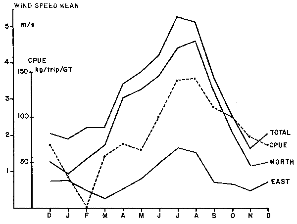
Figure No 11 : Mean monthly wind speed and its north and east components at Essaouira (1945-1980) in m/s, and mean monthly CPUE of sardines at Safi-Essaouira (1968-1981)
Two observations can be made from Figure 12. First, the average wind speed at Essaouira has diminished progressively since 1945, while displaying inter-annual fluctuations of a certain amplitude. This decline has been particularly marked since 1975, the observed average speeds being inferior to the slope of the regression line for the period from 1945 to 1980. Faced with this result, there was some concern as to the viability of the anemometers. The long-term decrease could be due to fatigue. After an inquiry, it turned out that the anemometers could not be at fault. Their dates of verification or replacement did not correspond to significant changes in recorded wind speed.
Second, the average direction of the winds has also changed within this 35-year period. Between 1945 and 1960, the azimuth oscillated between 350° and 20° (average: 5°). Between 1961 and 1980, the azimuth varied between 350° and 60° (average: 26°). Since 1960, there has been a small shift toward the east in the average direction of the winds.
These long-term changes in average wind speed and direction at Essaouira have probably had repercussions on the productivity of the Safi/Essaouira region.
Wind speed and sardine catch. Catches of sardines in the Safi/Essaouira fishery increased till the end of the 50's because of the growth of the fleet and technological improvements in the form of synthetic fiber nets and sounders. Starting from the beginning of the 60's, catches levelled off at about 70,000 tons as the size of the fleet increased only slowly. Catch per unit effort is a better indicator of local sardine abundance but accurate data are not available for the Safi/Essaouira area before 1970.
Average wind speed represents the energy which drives the pumping of nutrient salts from depth, since the average orientation of the winds remains more or less parallel to the coast (about 20°). We know that the action of the wind is proportional to the square of its speed. We also know from the work of Grall et al. (1982) in this region that mixing limits primary production and that primary production is more important when the winds weaken after a period of strong activity in which nutrient salts are brought up to the euphotic zone. The force of the wind thus plays an important role in enriching the environment and its variability allows better utilization of the nutrients in photosynthesis. In order to take into account these two factors, annual catch and CPUE were compared successively with the square of the average wind speed, its variance and both at the same time. The data used is given in Table 3.
Correlation coefficients for the different regressions are the following:
Simple correlations (Figures 13 and 14):
| Catch | CPUE | |
|---|---|---|
| (mean wind speed)2 | r = +0.734 | r = +0.736 |
| variance of the mean | r = +0.405 | r = +0.837 |
| Multiple correlations: | ||
| catch | CPUE | |
| (mean wind speed)2 = x1 | r = +0.771 | r = +0.916 |
| variance of the mean = x2 | ||
| Catch = 9.92 + 2.39 ×1 + 9.02×2 | ||
| CPUE = 8.01 + 1.95 x1 + 27.93 x2 | ||
| With: | catch in thousands of tons | |
| CPUE in kg per trip and per ton of gross tonnage | ||
| mean wind speed in (m/s)2 | ||
| variance of the mean in m/s | ||
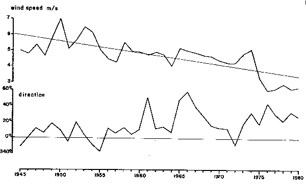
Figure No 12: Mean annual sppeds and directions of the wind at Essaouira from 1945-1980
| Year | Square of mean speed (m/s)2 | Variance of mean speed (m/s) | Sardine catch in thousands of tons | CPUE Kg |
|---|---|---|---|---|
| 1963 | 22.8 | 1.68 | 76 | - |
| 1964 | 16.7 | 1.40 | 71 | - |
| 1965 | 27.1 | 2.09 | 84 | - |
| 1966 | 25.3 | 3.32 | 123 | - |
| 1967 | 24.2 | 1.63 | 124 | - |
| 1968 | 22.8 | 1.57 | 83 | - |
| 1969 | 22.1 | 2.10 | 79 | - |
| 1970 | 19.7 | 2.28 | 77 | 128.2 |
| 1971 | 18.4 | 2.31 | 53 | 95.5 |
| 1972 | 18.5 | 1.65 | 55 | 90.5 |
| 1973 | 23.7 | 4.33 | 109 | 185.9 |
| 1974 | 26.8 | 2.38 | 64 | 115.9 |
| 1975 | 11.0 | 2.25 | 56 | 92.1 |
| 1976 | 6.5 | 1.26 | 36 | 78.0 |
| 1977 | 7.0 | 2.53 | 45 | 85.8 |
| 1978 | 8.6 | 1.96 | 31 | 69.6 |
| 1979 | 6.9 | 1.99 | 65 | 87.4 |
| 1980 | 7.7 | 2.25 | 53 | 74.8 |
These coefficients are all significant. The wind speed and its variation at Essaouira explain close to 84% of the variance in local sardine abundance, i.e. its availability within the fishing zone of the sardine boats from these ports. These two meteorological factors act together. They are not linked together by a significant correlation (r = 0.24). The agreement between the different factors and the local abundance for the same year shows that it is an availability of adult sardines in the fishing zone, and not a real increase in the stock by more important recruitment, the effect of which would only be felt in the following years.
Richebé (in press) carried out regressions between mean monthly wind speed (m/s) and monthly landings of sardines at Safi-Essaouira (tons) from 1965 to 1980 (192 mos.). He found a correlation coefficient of r = +0.43 in comparing landings and winds for the same months. When he compared landings with winds of the preceding month, a higher correlation coefficient was obtained: r = +0.53, which is quite significant. These coefficients are smaller than those calculated on an annual basis, probably because the fleet lays up for the winter for repairs and because catches are too small. These months of inactivity were nevertheless taken into account in the calculations of the correlations. This correlation measures the amount of connection between the two data series which vary in a cyclical manner through the year, and also on a long-term basis.
The authors have also calculated a monthly index of Ekman transport perpendicular to the coast from speeds and directions of winds observed at Essaouira. This monthly index was compared with landings of sardines a month later at Safi-Essaouira and a correlation coefficient of r = +0.46 was obtained. This index explains only 21% of the variance of the landings. It is probable that Ekman transport is not a very good index of primary production in the region of Essaouira because it does not bring in short-term factors of wind variability.
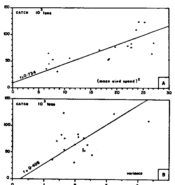
Figure No 13: Regression between
annual catches of sardines at Safi-Essaouria
in thousands of tons from
1963 to 1980 and:
A. The square of mean wind spped
(m/s)2 at Essaouria.
B. Variance of mean wind speed
(m/s) at Essaouria.
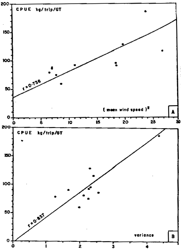
Figure No 14: Regression between
annual CPUE at Essaouira in
kg/trip/ton of gross tonnage
from 1970 to 1980 and:
A. The square of mean wind speed
(m/s)2 at Essaouira.
B. Variance of mean wind speed
(m/s) at Essaouira.
Generally, when the sardines are absent in winter and are found several hundred kilometers to the south of Safi-Essaouira, the occurrence of north winds does not provoke an immediate reaction in terms of local abundance, and does not increase catch. Mean annual data aggregates wind and catch factors for the whole of the fishing season, and gives better correlations.
In conclusion, the decrease in availability of sardines in the fishing zone of Safi-Essaouira is caused largely by a weakening of the trade winds and attenuation of their short-term fluctuations. The remaining variance, that is not explained by the correlation, could be partly due to real variations in abundance of the stock, and partly because the fleet at Agadir takes increasingly important amounts of sardines along the migration path. The real or actual abundance of the stock is primarily controlled by enfironmental factors to the south of Agadir, where the major part of the population is found and where the winter and spring reproduction takes place; and secondarily, by the catch from zones A and B.
ABUNDANCE OF SARDINE AND INDICES OF UPWELLING IN THE SOUTH OF THE MOROCCAN FISHERY (ZONES B AND C)
Zone B
We have seen that in winter, the sardine stock is concentrated in zone B and extends partially into zone A in summer. Spawning takes place primarily in winter and in spring, and it is probable that environmental conditions in zone B have an effect on recruitment and thus, on stock abundance. It is also possible that sardines of zone C may enter the southern part of zone B in autumn.
Available data. With regard to abundance, the variations in availability in zone A considered earlier do not allow the use of CPUE to determine a real index of abundance of the stock. Unfortunately, a corresponding series of CPUE for zone B is not available. Data on total catches are available since the start of the fishery (1965), but were of low values since the fleet was then small and perhaps, statistics were insufficient. Regular sampling of catches did not start till 1973 in zone A, and not till 1976 in zone B. The distribution of age classes in the two fisheries are different and do not allow the extrapolation of age composition of catches of zone A to catches of zone B. The sardines fished in zone A are, on the average, younger. Cohort analysis of the whole stock is therefore, limited to six years only (1976-1981). Catch by age class data submitted to the Ad hoc Working Group on the Sardine of the CECAF by Belvéze (1981), Delgado et al. (1979, 1982), and Fernandez (pers. comm., 1981) were regrouped. Cohort analysis using M = 0.6 and Ft = 0.5 gave estimates of recruitment, abundance and biomass for the first of January, as shown in Table 4.
![]()
![]()
![]()