0075-B1
Mariângela Vidal[1], Francis Dubè and Wayne A. Geyer
This study analyses the use of an agroforestry system to reclaim landscape spoiled by kaolin mining in the Quebra-Côco Mine, city of Ubá, Minas Gerais State Forest Zone, Brazil. The results were collected from March 1999 to March 2001. Topographic and climatic conditions, neighbouring vegetation, soils and erosion risks were evaluated. The species used were Piptadenia gonoacantha, Mabea fistulifera, Mimosa flocculosa, Acacia mangium, Pinus oocarpa, Eucalyptus grandis, Saccharum officinarum, Brachiaria decumbens and Mucuna sp. Visual impacts of the vegetation recover of the area were observed. Greater stability, an increase in soil fertility and the beginning of the formation of an organic layer, biological activities in the soil, the presence of insects, fungi and other animals were observed in an area once considered inhospitable.
Kaolin mining activities begins with mineral characterization, evaluation of its quality and the recovery and transport of associated residues. It involves the extraction of a large volume of clay and rocky materials, causing major changes in environmental conditions. (Williams et al. 1997).
Current international product trade considers sustainable development using conservation and the ecological concepts where political, social and economic decisions may become critical. Many consumers prefer to purchase natural or manufactured products that have been obtained in a sustainable way, that is, products obtained from processes in accordance with environmental and quality considerations, such as ISO 14001 and ISO 9001, respectively (Canadian Standards Association, 1996). Moreover protests for products that do not comply with these new concepts of production have been registered. Factors like these have a great impact in changing the way mining companies are managing their activities. Therefore studies to mitigate environmental impacts are of great importance to mining companies in extraction of kaolin and other minerals.
Due to the danger of desertification at the national and international levels and the application of the legal requirements of PRAD (Recovery Plan for Degraded Areas), both mining companies and governments have been supporting research for the reclamation of degraded areas.
Looking for a simple, efficient and economically viable technique, this study proposes the use of an agroforestry system to reclaim land degraded by kaolin mining in the city of Ubá, Minas Gerais Forest Zone, Brazil.
The Quebra-Côco Farm, which belongs to the Company Mineração Caolinita Ltda (MCL), City of Ubá, Minas Gerais Forest Zone, Brazil, was chosen for the case study. The area was characterized by kaolin mining over the last 47 years. In that period, it was used also as a deposit for residual material originating from its processing. In this inhospitable scenario, characterized by a hot and humid climate, where the C horizon of the soil was severely exposed and suffering the action of weathering and erosion, there was an urgent need to mitigate the associated negative environmental and visual impacts.
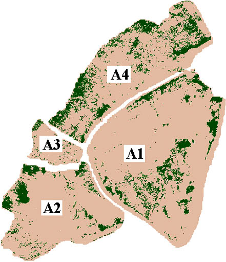
The experimental area consisted of 3,47 hectares, which was divided in sub-areas, as described in Table 1. It was monitored on a weekly basis from March 1999 to March 2001.
Table 1 - Characterization of the sub-areas of the Quebra-Côco Mine, Minas Gerais, Brazil.
|
Sub-areas |
Characteristics |
|
A1 |
Heterogeneous area in regards of its physical and chemical aspects, once used as a deposit for kaolin mining residues. |
|
A2 |
Old deposit area of kaolin mining residues, with a sterile, exposed C horizon, highly eroded. The relief is undulating and the soil is poor and crumbly. In the rainy season it constantly loses sediments and therefore degrades. |
|
A3 |
Flat land located in the lowest part of the area, at the bottom of the slope, constituting a hydromorphical zone. |
|
A4 |
Old quartz deposit area, submitted to heavy machinery work, having flat relief, drained and stony soil. |
Source: Vidal (2001)
The climate of the area is sub-tropical humid with an average annual rainfall ranging from 1,200 mm to 1,500 mm. At an average elevation of 380 meters, the soil is classified as yellow red Latosol, sandy texture and average pH of 5.9. The physical, chemical and biological analysis of the soil, the vegetation and the biological activity were conducted both in the field and at the Soil Laboratory of the Federal University of Viçosa, following the EMBRAPA (1999) methodology. The area is located between geographical coordinates UTM 709000 and 708500 E, and UTM 7661500 and 7660550 N (Vidal 2001).
The characterization of the area included topographical measurements, terrestrial and aerial photographs, soil analysis and a vegetation inventory. Data were processed using IDRISI, a Geographic Information System program. The maps of the area were made at the Remote Sensing Laboratory of the Federal University of Viçosa, using the IDRISI program and the geo-referred points from the field measurements.
The species used to reclaim the land included gramineas (Brachiaria decumbens, Saccharum officinarum and Oriza sativa) and leguminous (Mucuna sp.) pastures, and tree and shrub species (Eucalyptus grandis, Pinus oocarpa, Acacia mangium, Piptadenia gonoacantha, Mabea fistulífera and Mimosa flocculosa). The choice of the species used was based on the studies of the native forest fragment surrounding the mine, which also was a source of plant materials to colonize the area. Seeds of gramineas and legumins were sowed, while sugar-cane stakes were planted as well as seedlings for the tree and shrub species.
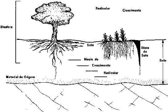
The main reason for using agroforestry to reclaim this degraded land was to enhance organic matter cycling and root growth at various soil depths, as shown in Figure 1. This practice increases soil fertility, and improves the landscape recomposition in a short period of time, in a gradual process of visual and environmental recovery (Reinert 1998).
Figure 1. Root growth at several soil depths in an agroforestry system (Vidal 2001).
|
LEGEND |
|
|
Crescimento radicular = root growth |
Solo = soil |
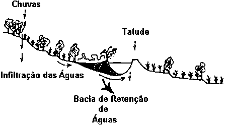
Given the current physical soil conditions, mechanical preparation was the only method recommended. Soil embankments at the bottom of the slopes to retain rainfall runoffs, and level contour curves along the slopes to control the erosion and allow plant establishment were constructed. Afterwards, the area appeared similar to that shown in Figure 2. All the others activities, such as the construction of energy dissipators for runoffs, planting, irrigation, and calcium and fertilizers soil amendments were done manually. Maintenance was periodical, following technical recommendations. Fertilizer was incorporated in amounts and composition following the recommendations of the soil analysis results.
Figure 2. Agroforestry model adopted for the studied area (Vidal 2001)
|
LEGEND |
|
|
Chuvas = rainfall |
Infiltração das águas = water infiltration |
There was a positive visual impact in the experimental area delimited by the yellow line (Figures 3 and 4). During the study period the recovery of vegetation of the area was 74,5% (Table 2). However, an increased degradation was observed in the remaining non-treated areas. This shows the necessity of human involvement in recovering degraded lands.
Figure 3. Aerial photographs of the Quebra-Côco Mine, Minas Gerais, Brazil, before (a) and after (b) the application of the treatment (Vidal 2001).
(a) Aerial photograph - March 1999.
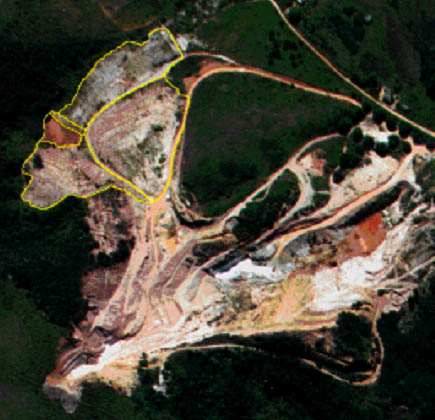
(b) Aerial photograph - March 2001.
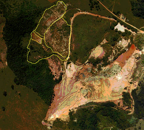
Figure 4. Vegetation recovery before (a) and after (b) the treatment. The dark color represents the vegetation while the light colors show the non-vegetated areas. Quebra-Côco Mine, Minas Gerais, Brazil (Vidal 2001).
(a) Aerial photograph - March 1999.
(b) Aerial photograph - March 2001.
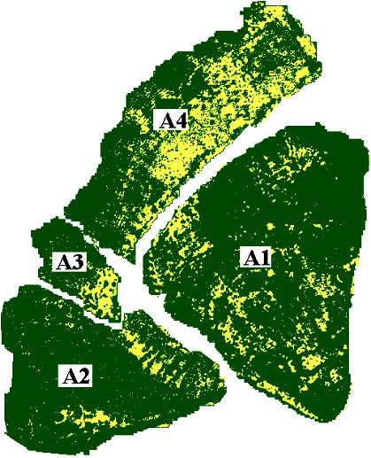
Table 2. Vegetation recovery from March 1999 to March 2001, Quebra-Côco Mine, Minas Gerais, Brazil.
|
Sub-areas |
Recovered Vegetation (%) |
Gain (%) |
|
|
March 1999 |
March 2001 |
1999-2001 |
|
|
A1 |
10.5 |
88.0 |
77.5 |
|
A2 |
9.8 |
92.0 |
82.2 |
|
A3 |
6.2 |
82.0 |
75.8 |
|
A4 |
19.2 |
68.0 |
48.8 |
|
Total area (average) |
8.2 |
82.7 |
74.5 |
Source: Vidal (2001)
The vegetation, consisting of trees, shrubs, grasses, and gramineas / legumins pastures, appears much more dense and developed. The gramineas grew vigorously under the trees, which allowed the presence of fungi. Readily available chemical fertilizers, manure and water facilitated also the silvicultural treatments, such as fertilization and irrigation.
Survival of the tree and shrub species gave the following results: Eucalyptus grandis (100%), Acacia mangium (97,7%), Piptadenia gonoacantha (93,5%), Mimosa scrabella (86,6%), Mabea fistulifera (63%) and Pinus oocarpa (0%).
An increase of biological activity of the system as a whole was obtained. Soil analysis revealed an increasing fertility and a decreasing compaction and soil crumbliness, as a consequence of the use of different species to promote roots in reaching several soil depths.
The use of agroforestry to reclaim land degraded by mining is a viable option in regards to environmental, economic and landscape aspects, in accordance with the results of Dubè (1999), Dubè et al. (2002), Geyer and Dubè (2001) and Vidal (2001). The results show that without human interference this process would not happen so efficiently and in as a short time period.
Mimosa flocculosa was the species that best completed its life cycle, demonstrating its great potential to recover degraded lands.
This study indicates that important changes occurred in the environment due to the return of animal life and vegetation. The area is in a process of landscape evolution, and (i) the micro-environment formed by the soil-plant complex is beneficial to the presence of animals, to plant growth and natural regeneration. This indicates the initial process of formation of a diversified flora would be the food source to several propagating organisms; (ii) the diversity of the species used was quite efficient in promoting the vegetation cover; (iii) the plants used showed good survival; (iv) the incorporation of organic matter was of great importance to the improvement of the physical, chemical and biological characteristics of the soils; (v) the soil fertility results differ greatly from the expected for a common soil and they provide a good idea on what happened before in the area. The low clay content of the soil samples, which was almost all dispersed, demonstrates that flocculation does not exist among the particles and that this soil is not totally reclaimed yet; (iv) the industrial residues showed high pH and high contents of calcium, phosphorus, zinc, iron, and manganese, and could have the potential to be used as a soil conditioner; (vii) the heavy metals content found in those residues, in the water and in the leaves of the plants indicated that more studies should be carried out prior to other uses, mainly because of cadmium that, although it has not been found in toxic levels for the plants, has the capacity to bio-accumulate (viii) finally, these data allow us to conclude that the area is in the initial recovery process and that the applied treatment tends to accelerate the process of ecological succession.
An overall increase of soil fertility was observed, which increased vegetation cover in the studied area and the growth of new roots at several soil depths. This fact is beneficial to the infiltration of rain water and the retention of soil humidity, which also helps with the control of erosion. As a consequence, an important increase of biological activity of the micro-fauna was observed, as well as the presence of fungi, insects and other animals in a place once considered inhospitable.
The authors want to acknowledge Mineração Caolinita Ltda (MCL) for their support. Thanks are also due to the Society for Forest Research (SIF), the National Council for Research and Technical Develoment (CNPQ) and the Federal University of Viçosa (UFV) for supporting this research.
Canadian Standards Association, 1996. The ISO 14000 Essentials: A practical guide to implementing the ISO 14000 Standards. Plus 14000. McKinley, K. and White, W. Eds. Etobicoke, 97 p.
Dubè, F., 1999. Estudos técnicos e econômicos de sistemas agroflorestais com Eucalyptus sp. no Noroeste do Estado de Minas Gerais: O caso da Companhia Mineira de Metais. M.Sc. thesis, University Press, Viçosa, 150 p.
Dube, F., L. Couto, M.L. Silva, H.G. Leite, R. Garcia and G.A. Araujo, 2002. A simulation model for evaluating technical and economic aspects of an industrial eucalypt-based agroforestry system in Minas Gerais, Brazil. Agroforestry Systems. (under press)
EMBRAPA - Empresa brasileira de pesquisa agropecuária, 1999. Centro Nacional de Pesquisa de Solos. Manual de métodos de análise de solo, Rio de Janeiro, 212 p.
Geyer, W.A. and F. Dubè, 2001. Agroforestry practices in Brazil. 133rd Annual Meeting of the Kansas Academy of Science, April 6-7, Vol.20.
Reinert, D.J., 1998. Recuperação de solos em sistemas agropastoris. In: Dias, L.E. and Vargas, J.W.M. (Eds.) Recuperação de áreas degradadas. Sociedade Brasileira de Recuperação de Áreas Degradadas. Viçosa, p.163-176.
Vidal, M., 2001. Revegetação de área degradada pela mineração de caulim na Zona da Mata, em Minas Gerais: um estudo de caso. M.Sc. thesis, University Press, Viçosa, 66 p.
Williams, D.D., Bugin, A. and Reis, J.L.B.C., 1997. Manual de recuperação de áreas degradadas pela mineração: técnicas de revegetação. IBAMA, Brasília, 96 p.
| [1] 500 Montagne Street, Suite
210, Montreal, QC, H3C 4T6, Canada. Tel: (514) 932-8692; Fax: (514) 932-8692;
Email: [email protected] |